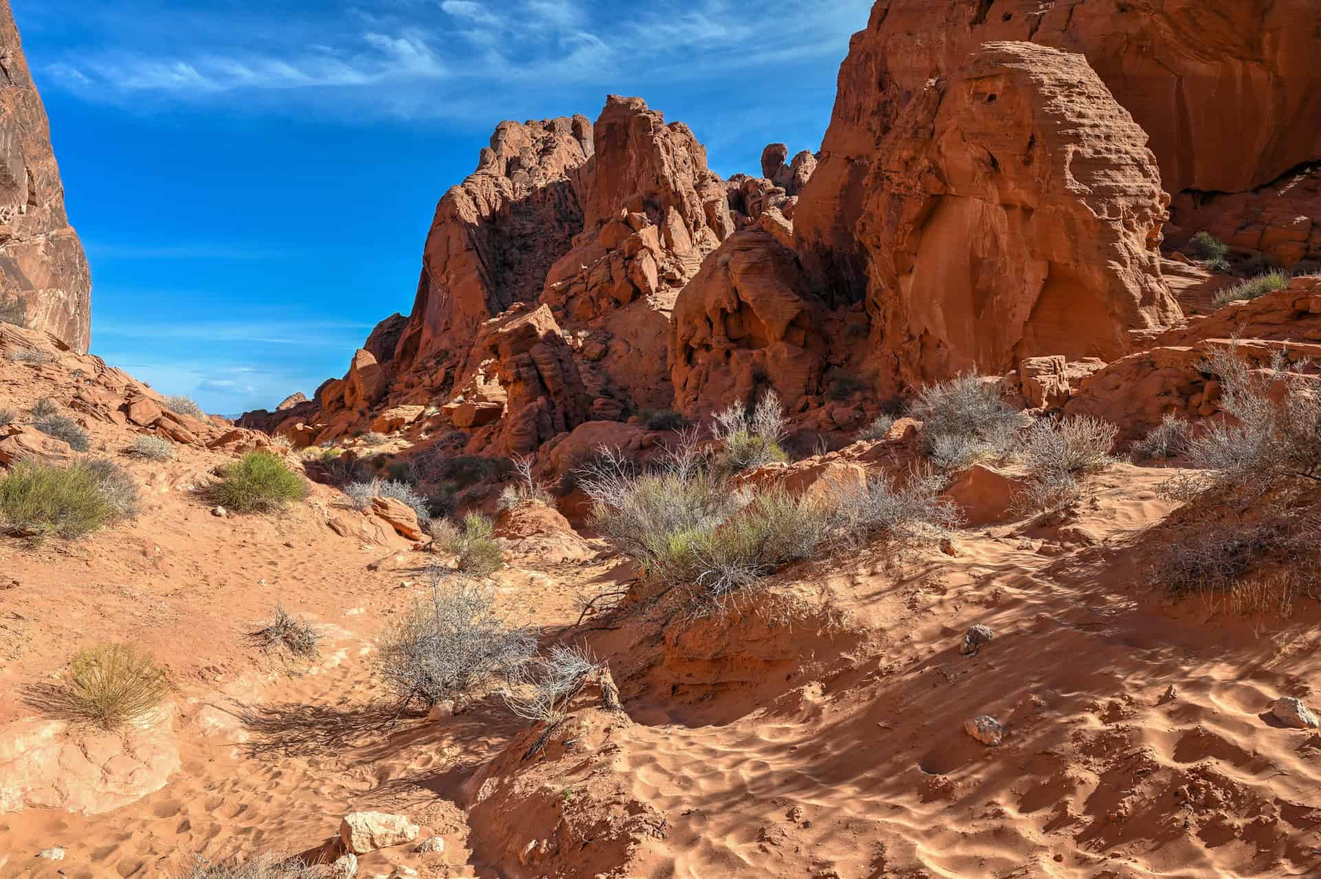
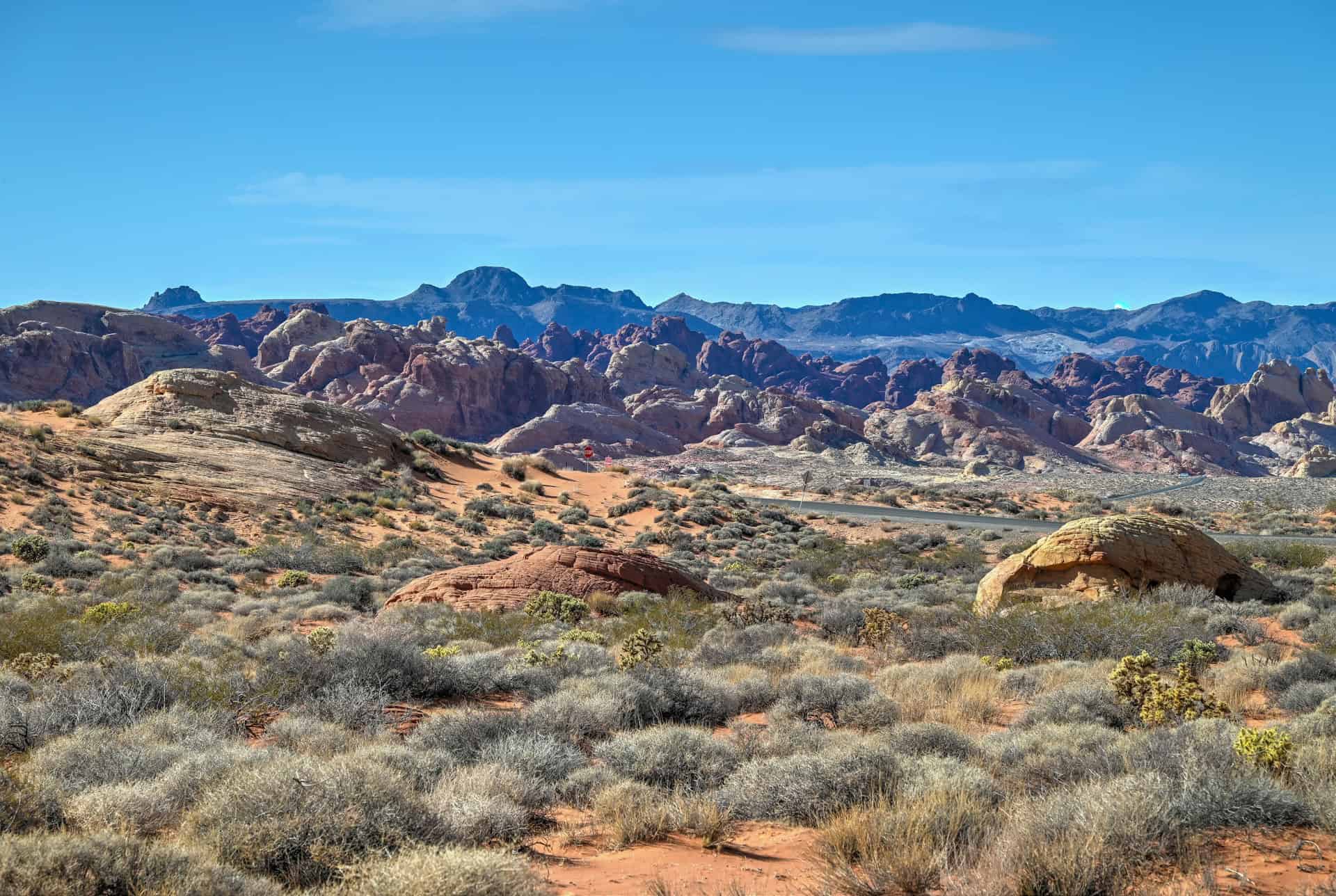
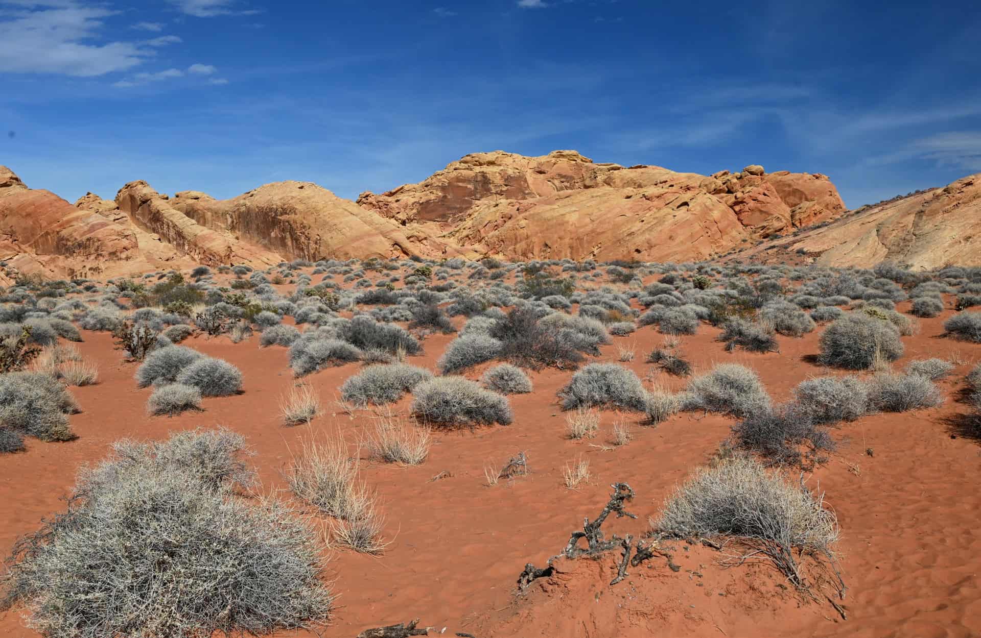
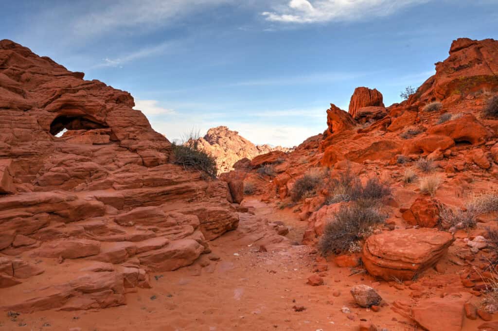
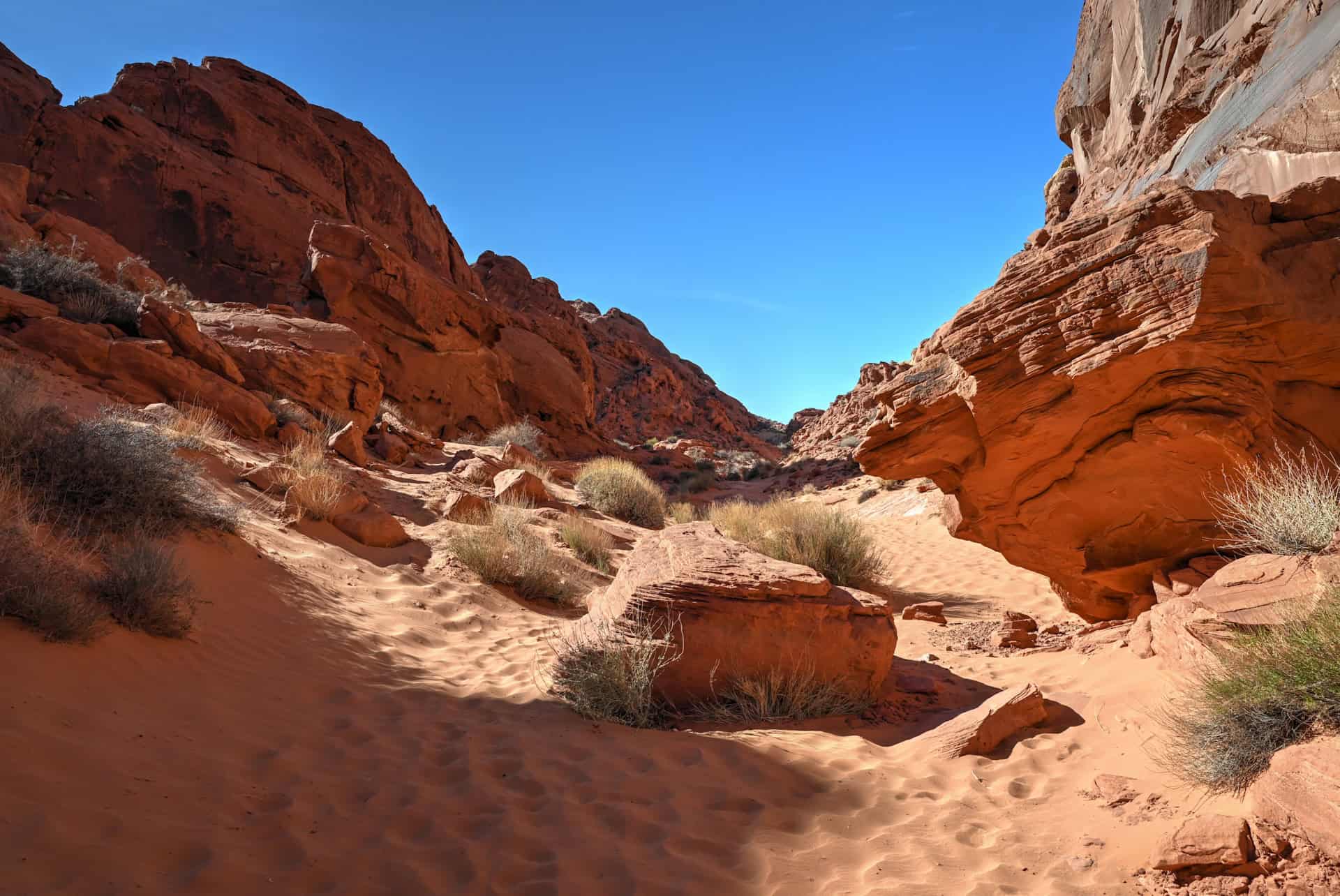
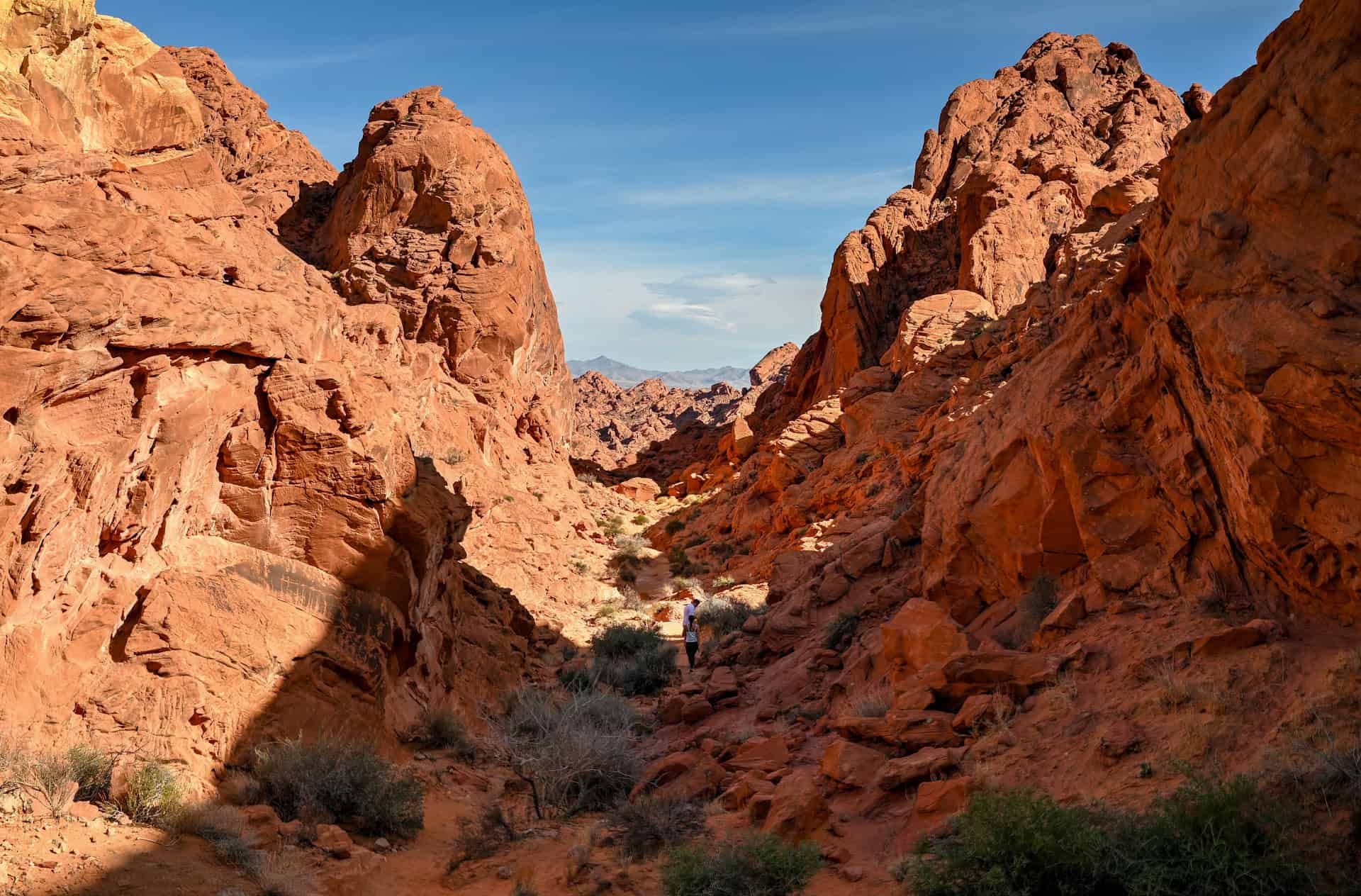
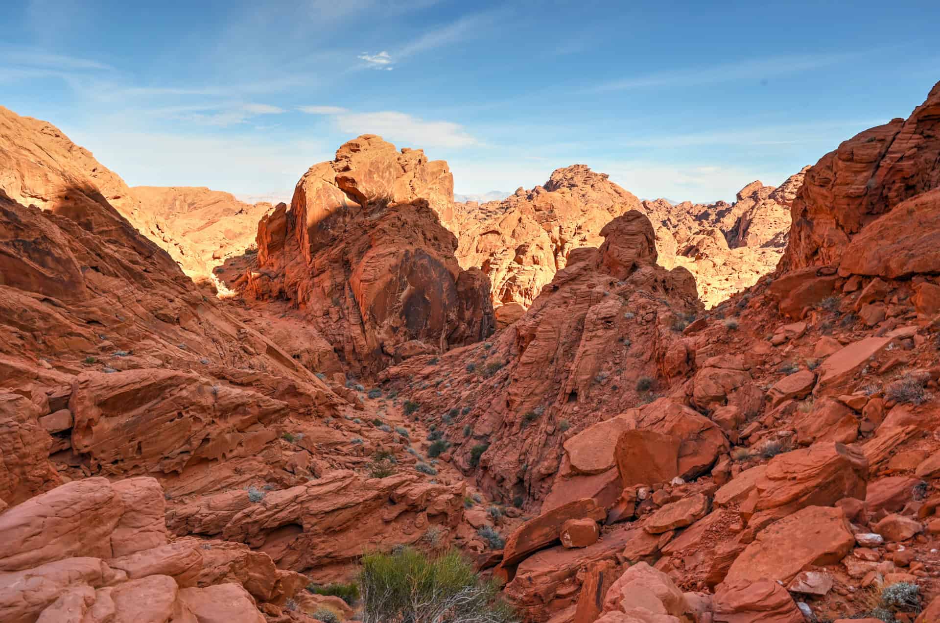
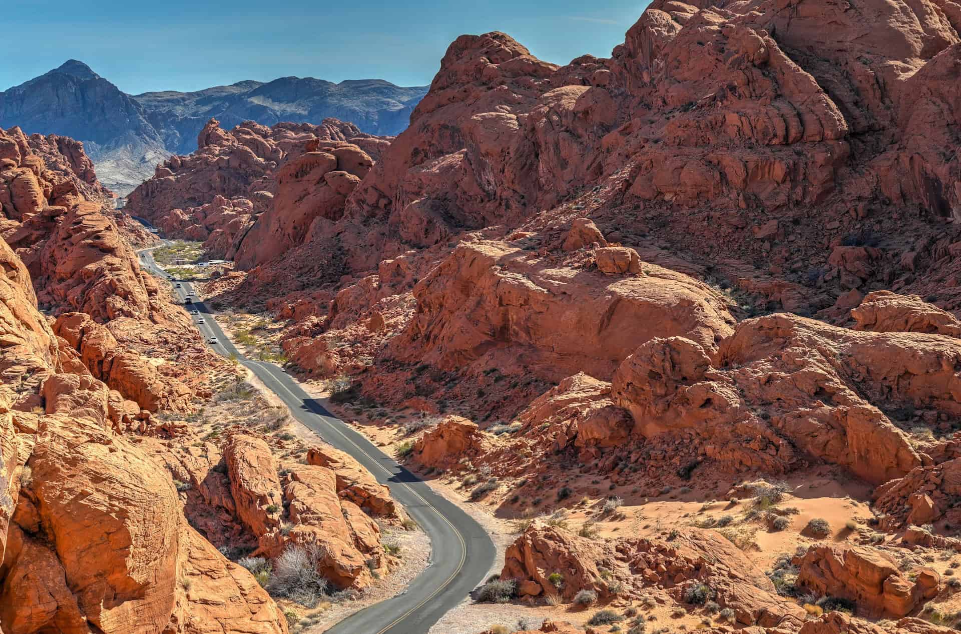
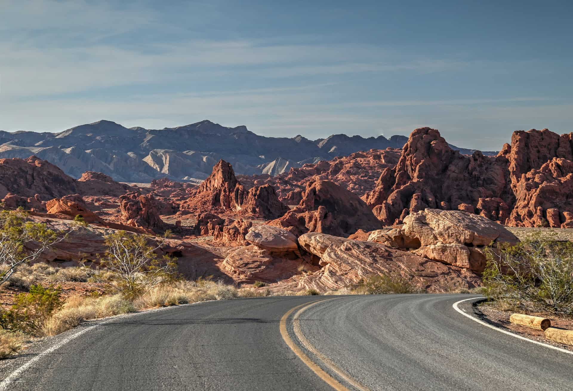
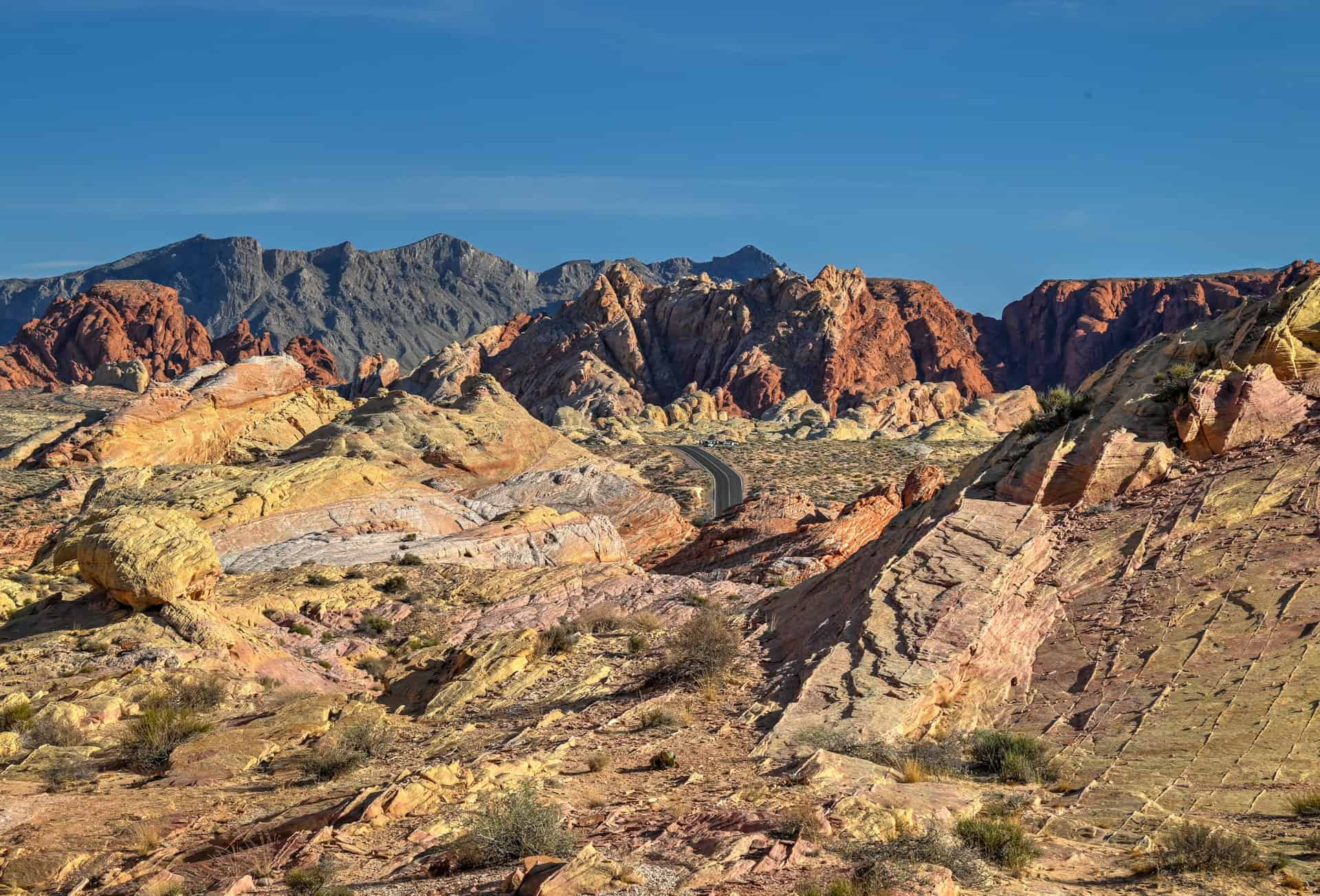
Tucked along the vibrant sandstone corridor of Mouse Tank Road, the Rainbow Vista Trail is one of Valley of Fire’s most colorful and accessible hikes. Starting in a stretch of open desert dotted with pastel sandstone outcrops, the Rainbow Vista Trail leads you along a sandy path before narrowing into a rocky, winding canyon that showcases some of Valley of Fire’s most vibrant colors. The route is short and easy, but surprisingly varied: one moment you’re walking across soft sand, and the next you’re weaving between sculpted walls. The trail ends at a wide overlook of Fire Canyon, a dramatic landscape of jagged ridges and glowing red rock that drops sharply away from the viewpoint. While simple and family-friendly, Rainbow Vista packs in a lot of scenery for such a quick hike, making it an ideal stop along Mouse Tank Road or a perfect complement to the Fire Wave or the White Domes trail.
Rainbow Vista Trail – At a Glance
A gentle introduction to Valley of Fire’s colors – Beginning in open desert, it’s an easy walk that immediately immerses you in the park’s signature palette without the crowds found at the Fire Wave.
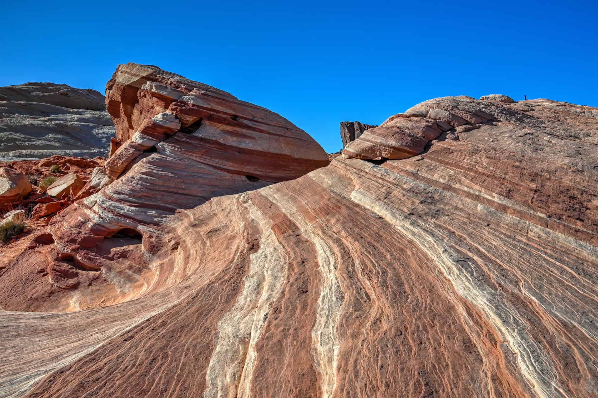
A funnelled path into a rocky canyon – After the sandy start, the route narrows into a rocky corridor where sculpted walls rise on both sides. This section offers some of the most enjoyable terrain on the trail: wists, turns, textured stone, and plenty of opportunities for photos.
An easy hike with a rewarding payoff – Though short and mostly level, Rainbow Vista feels surprisingly varied. The sandy sections provide a leisurely pace, while the rocky narrows add just enough adventure to keep things interesting for families and casual hikers.
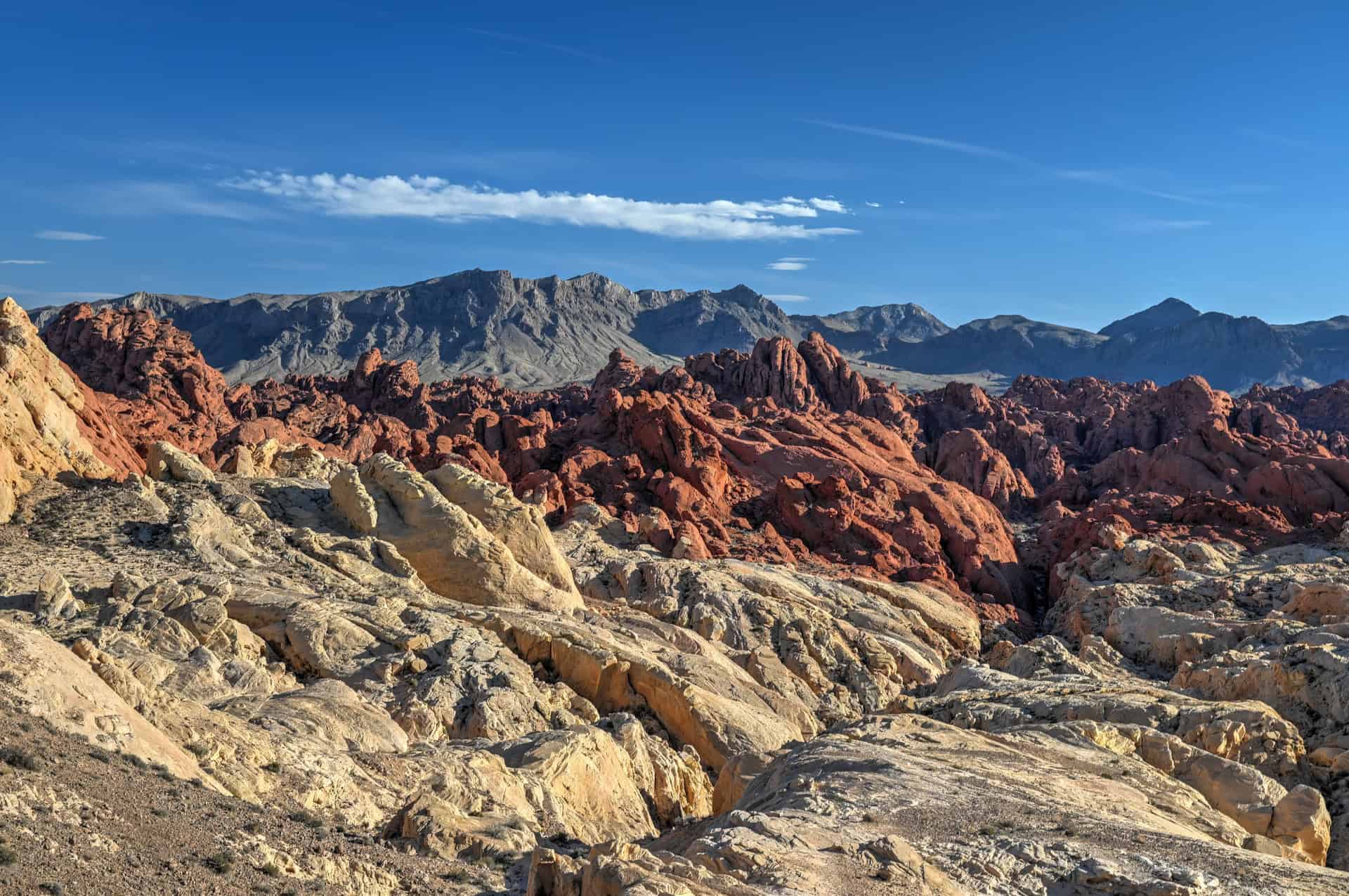
Ends at the Fire Canyon Overlook – The trail concludes at a wide, rugged viewpoint overlooking Fire Canyon: a landscape of glowing red ridges and jagged formations that drop sharply away from the overlook. It’s a dramatic contrast to the soft colors of the trail leading up to it.


Disclosure: This page (Rainbow Vista Trail – A Valley of Fire Hiking Guide) may contain product affiliate links. At no additional cost to you, we may receive a commission for purchases made through these links. More details can be found on our disclosure and policies page.
The Rainbow Vista Trail – Location and Map
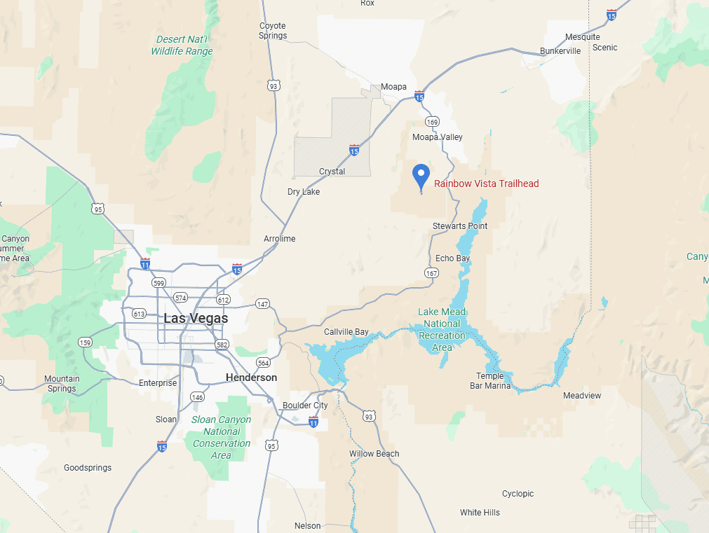
The Rainbow Vista Trail is located in Valley of Fire State Park, about one hour northeast of Las Vegas. This section of the park is known for its vibrant sandstone formations, narrow canyons, and richly colored desert landscapes, making it one of the most visually striking areas to explore on foot.
About Valley of Fire State Park
Nevada’s Fiery Desert Wonderland: Valley of Fire State Park sits in the Mojave Desert northeast of Las Vegas, where waves of blazing-red sandstone rise from pale desert plains. The park’s name comes from the way these formations ignite in brilliant shades of orange and scarlet when struck by the sun, especially at sunrise and sunset. With its swirling rock stripes, slot-like passages, and vast open panoramas, Valley of Fire feels like a natural sculpture garden carved by wind, water, and time.
A Landscape Sculpted Over 150 Million Years: The park’s famous red rocks are part of the Aztec Sandstone, remnants of ancient sand dunes from the Jurassic era. Over millions of years, erosion etched these dunes into ridges, fins, domes, and wave-like formations, including the Fire Wave, Pink Canyon, and Crazy Hill. The result is a landscape full of surreal textures and colors: deep reds, peachy pastels, bright whites, and smooth stripes that twist like painted brushstrokes.
A Haven for Short, Scenic Hikes: Valley of Fire is packed with accessible but unforgettable trails. Routes like the Fire Wave, Seven Wonders Loop, and White Domes lead you through narrow canyons, crossbanded sandstone, and wide-open slickrock. These hikes are generally short, making the park ideal for half-day and full-day visits where you can experience several standout features without long mileage. Even roadside pullouts, like Elephant Rock, Atlatl Rock, and Rainbow Vista, offer quick access to photogenic viewpoints.
Rich Indigenous History and Petroglyph Sites: Long before it became Nevada’s first state park, this region was home to the Ancestral Puebloans and later the Southern Paiute people. The park preserves thousands of years of rock art, with petroglyph panels carved into desert varnish across sites like Mouse’s Tank and Atlatl Rock. These carvings offer meaningful insight into the region’s early inhabitants and their relationship with the desert landscape.
Easy Access From Las Vegas: Just one hour from the Las Vegas Strip, Valley of Fire is one of the Southwest’s most convenient natural escapes. Its well-maintained park roads create a scenic driving route through the heart of the landscape, making it easy to combine hikes with overlooks, photo stops, and picnic areas. Whether you’re here for sunrise photography, a quick half-day adventure, or a full day of rock formations and desert trails, Valley of Fire delivers some of the most vibrant scenery in the Mojave.
How to Get to Valley of Fire State Park
The Valley of Fire State Park is best reached by car, as there is no public transportation directly to the trailhead.
Valley of Fire State Park has two main entrances, both accessible by paved roads:
- West Entrance (via Valley of Fire Highway):
Best for visitors coming from Las Vegas or other destinations in southern Nevada. This is the most commonly used entrance and offers the quickest, most direct access from the city. - East Entrance (via the Northshore Road / Lake Mead National Recreation Area):
Ideal for travellers arriving from Utah, Arizona, or the eastern side of Lake Mead, including St. George, Zion, Page, and other points east. This entrance offers a quieter, more scenic approach.
Regardless of which entrance you use, all main roads inside the park are paved and suitable for any vehicle.
Driving times to Valley of Fire State Park
- Las Vegas, NV: 85 km / 50 mi – about 1 hour
- St. George, UT: 150 km / 95 mi – about 1.5 hours
- Zion National Park (Springdale, UT): 185 km / 115 mi – about 2 hours
- Page, AZ: 435 km / 270 mi – about 4.5 hours
- Flagstaff, AZ: 420 km / 260 mi – about 4.5 hours
These times assume clear weather and normal traffic conditions. The last stretch of the drive, from the park entrance to the Fire Wave trailhead, is fully paved and suitable for all vehicles.
If you need to book a rental vehicle for your hiking excursion, we highly recommend using Discover Cars to get the best rates on your rental in Utah, Nevada and Arizona.
We also highly recommend Airalo (eSIM card) for your connectivity needs when travelling abroad. Airalo is the world’s first and largest eSIM store with eSIM plans for 200+ countries and regions worldwide.
Group Excursion from Vegas
Alternatively, if you don’t have a car and are staying in Las Vegas, you can still visit Valley of Fire by joining an organized tour from the city. Several companies offer full-day or half-day excursions, including one that focuses on catching the park at sunset, and another that combines Valley of Fire and Red Rock Canyon into a single day trip. These are among the most popular options:
Rainbow Vista Trail – Trailhead, Parking & Fees
Trailhead Location: Rainbow Vista Trail begins along Mouse Tank Road, the scenic drive that cuts through the heart of Valley of Fire State Park (link to Google Maps).
Trailhead parking lot: A small paved parking area directly next to the trailhead, with room for maybe a dozen cars at most. This lot fills quickly during peak hours (mid-morning through mid-afternoon), especially on weekends and during spring months.
Facilities: There are vault toilets at the trailhead.
Trail opening Hours: Valley of Fire State Park is generally open sunrise to sunset, though hours can vary seasonally. The trail itself is accessible only during park open hours.
Seasonal Closure: Unlike many other trails in the park, the Rainbow Vista trail typically remains open during the closure period, from May 15 to September 30, due to extreme heat and safety concerns.
Entrance Fees for Valley of Fire State Park
Valley of Fire charges a per-vehicle entrance fee, payable at the park entrance station:
$15 per vehicle for out-of-state visitors
$10 per vehicle for Nevada residents
Fees must be paid before accessing the Scenic Drive or any trailheads, including the Fire Wave.
The park does not accept the America the Beautiful Pass, as it is a Nevada State Park.
Rainbow Vista Trail – Details and Map
Distance: 1 mile (1.6 km)
Route Type: Out-and-back
Elevation gain: 100 ft / 30 m (cumulative elevation gain)
AllTrails rating (2025): 4.5, 1833 ratings
Duration: Most people complete the full trail in 25-40 minutes
Trail difficulty level assessment:
Very Easy | Easy | Moderate | Moderately Challenging | Challenging
Overall, the Rainbow Vista Trail is best described as Easy. We contemplated giving it a “very easy” rating, as it is very easy for the most part, but decided to bump it up to “easy” due to a few slightly more challenging sections.
Not an AllTrails member yet? We highly recommend signing up for either their free or paid membership plans. The free plan allows you to find new trails and plan routes but it can only be used while hiking if you have access to mobile data. The paid membership plan (AllTrails+) allows you to download trail maps for offline use and provides live progress updates and off-route notifications.
If you are still uncertain – you should know that the All Trails mobile application was voted the 2023 iPhone App of the Year by Apple.
We find that AllTrails is a great tool to have when hiking, particularly for assisting with navigation when the trail is hard to locate and to help monitor your progress along the trail, which helps estimate how much time you’ll need to complete the trail.
Rainbow Vista Trail – Description and Summary
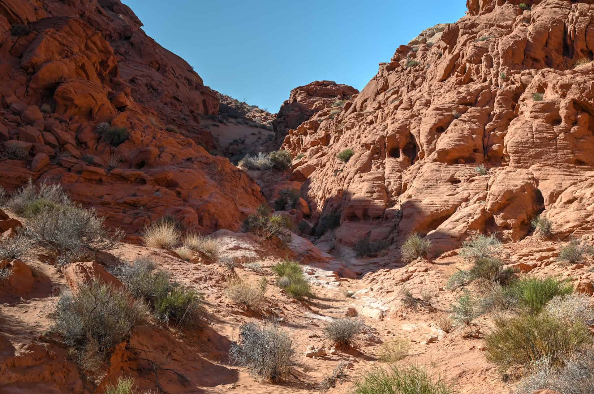
The Rainbow Vista Trail begins with a gentle walk across open desert, following a wide, sandy path framed by various rock formations. This early stretch is flat and easy, giving you time to settle into the landscape and appreciate the subtle color variations that give the trail its name. Low ridges and scattered domes appear on the horizon, hinting at the more dramatic terrain ahead.
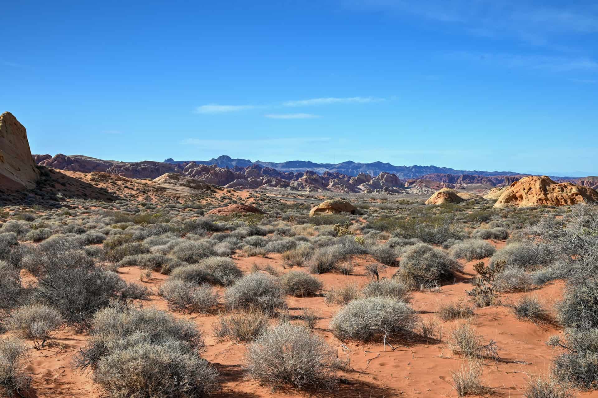
After the first 0.3 km (0.2 miles), the trail begins a gradual descent, funnelling hikers toward a shallow, rocky canyon. Here, the route becomes more engaging: the sand occasionally gives way to firmer rock. The canyon section requires good footing, with a few short drops where light scrambling may be needed to navigate small ledges or uneven steps. These spots are not difficult, but they add a fun, adventurous element to an otherwise easy trail.


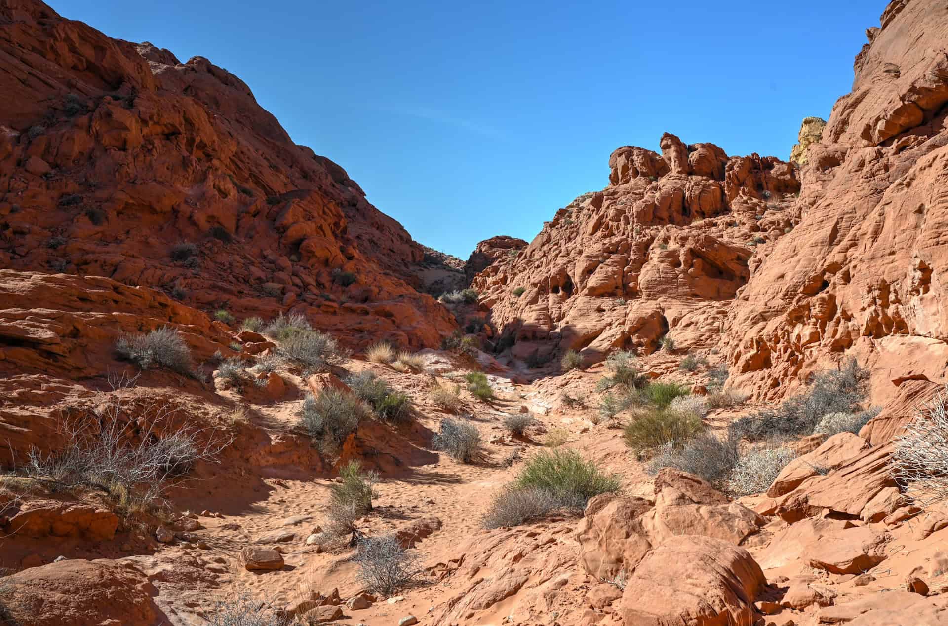
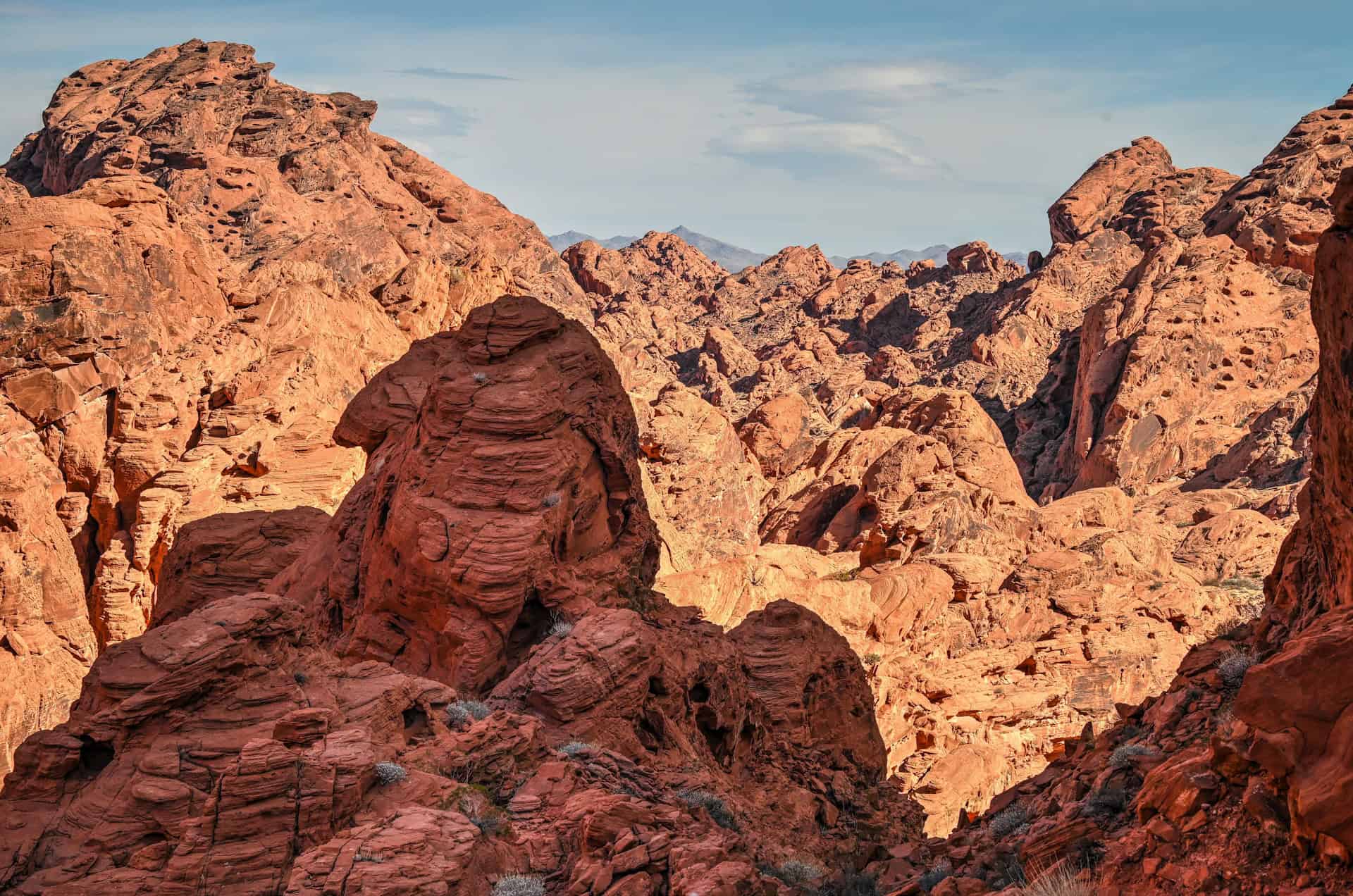
The descent continues almost consistently downhill, leading you toward the lowest point of the route: the Fire Canyon Overlook. The final approach opens suddenly to reveal a sweeping, rugged vista—jagged ridges of deep red rock, eroded gullies, and the dramatic, fiery landscape that gives the overlook its name. It’s an excellent place to pause, take photos, and appreciate the depth of Valley of Fire’s geology.
After enjoying the viewpoint, simply retrace your steps uphill through the canyon and across the sandy desert back to the trailhead. While the return requires a bit more effort due to the incline, it’s steady and manageable for most visitors.
Rainbow Vista Trail – Additional Details and Hiking Tips
Canine companions: Dogs are allowed on the Rainbow Vista Trail but must remain leashed at all times. Keep in mind the sand and rock can get extremely hot in warm weather—protect paws accordingly.
Trail environment: The trail begins in open desert and transitions into a narrow, rocky canyon before reaching the Fire Canyon Overlook. Shade is virtually nonexistent (the canyon provides brief partial shade depending on the angle of the sun, but not enough to rely on), and the combination of reflective sand and bare rock makes this one of the hottest short hikes in the park. Bring ample water, sun protection, and a hat—even in spring and fall.
Route signage: The trail is straightforward and well-marked, with clear signs at the trailhead and small markers or worn footpaths guiding hikers through the sandy sections and into the canyon.
Trail surface / Technical aspects: Rainbow Vista is generally easy, but it includes mixed terrain. The sandy opening stretch is simple to navigate, while the canyon section requires more careful footing across uneven rock. One or two short drops may require light hands-on scrambling, but nothing technical. Sturdy shoes with good traction are highly recommended.
Slope and effort: This is an out-and-back route with a mostly gentle downhill grade on the way to the overlook (and steady uphill on the return). Elevation changes are modest, but the heat, sand, and rocky footing can make the hike feel slightly more strenuous than the distance suggests.
Previous Hiking Experience: The trail is beginner-friendly and suitable for families, casual hikers, and anyone comfortable walking on sand and light rock. Those new to desert hiking should be prepared for the heat and bring more water than expected, especially since the return is entirely uphill.
Cell Service: Cell reception is spotty. The open desert at the start may have a weak signal, but coverage usually drops in the canyon and at the overlook.
Leave No Trace: Stay on the designated route to protect fragile desert soils and prevent erosion in the canyon. Avoid climbing on delicate rock formations, refrain from creating new social trails, and pack out all trash.
Bugs: Insects are minimal year-round. Gnats may appear on warmer days or after rain, but mosquitoes and ticks are rare. Bug spray is optional.
Equipment: No technical gear is needed. Wear sturdy shoes or trail runners with a good grip for sandy and rocky sections. Bring plenty of water, sun protection, sunglasses, and a hat. Trekking poles can help with the sandy return uphill, but are not necessary for most hikers.
Weather and Exposure: Rainbow Vista is fully exposed from start to finish. Even on cooler days, the dark red sandstone radiates heat. Avoid midday in summer. If hiking in winter, be aware that shaded rock shelves in the canyon can occasionally hold icy patches early in the morning.
Wildlife: Expect to see lizards, birds, and small mammals along the trail. Desert wildlife is most active early or late in the day. Rattlesnakes may be present during warmer months, so remain cautious around rock crevices and shaded areas. But no need to panic – encounters are extremely rare.
Current Trail Conditions: Check the Valley of Fire State Park alerts page for any updates on trail closures, heat-related restrictions, or special advisories.
Best Time to Hike the Trail
Rainbow Vista Trail is open year-round, but seasonal conditions affect comfort, temperature, and lighting:
Spring (March–mid May):
Spring is one of the best times to hike Rainbow Vista. Daytime temperatures typically range from 65–85°F (18–29°C), and the desert sunlight highlights the soft pastel tones of the sandstone. Morning and late afternoon are ideal for cooler hiking and photography, though occasional breezes can pick up across the open desert sections.
Summer (June–August):
Summer can be extremely hot, with highs often exceeding 95°F (35°C). The open desert sections provide almost no shade, and the sandy trail can radiate heat. If hiking in summer, plan for early morning or late afternoon, bring plenty of water, sun protection, and consider shorter outings.
Fall (October–early November):
Fall offers warm days and cooler mornings, with highs typically in the 70s–80s°F (21–27°C). The softer sunlight enhances the reds, yellows, and creams of the trail, and crowds are generally lighter than in spring.
Winter (December–February):
Winter is quiet and comfortable for hiking. Daytime highs are usually in the 50s–60s°F (10–16°C), and mornings can be chilly, especially in shaded canyon sections. Snow is rare but can create striking contrasts on the sandstone.
Quick Summary – When to Visit
Spring and fall offer the most comfortable temperatures, scenic light, and enjoyable hiking conditions. Summer is doable with caution during cooler hours, and winter provides solitude and crisp air for early risers and photographers.
Hiking Packing List
All Trails subscription – This comes in really handy for areas with little or no cell reception, as the annual subscription allows you to download trail maps for offline use.
External Battery – If you are using your phone to track your progress along the trail or to help with navigation, you certainly don’t want your phone to die on you. That’s especially true in the unlikely event that you might get hurt or need assistance.
Hiking poles – These can be particularly useful in steep trails or muddy/boggy trail conditions.
Water Filter Bottle – The Life Straw bottle is an advanced water bottle with a filter that not only improves water taste but more importantly filters out bacteria and parasites, chemicals and microplastics.
Headlamp – very practical and a smart choice if you plan to start your hike before sunrise or finish it after sunset.
Want to Know More About Valley of Fire State Park?
If you’re planning a quick visit to Valley of Fire—whether as a half-day trip from Las Vegas or a scenic stop while travelling between Las Vegas and Zion National Park—you may want a broader overview than just the Rainbow Vista Trail. We’ve put together a dedicated Valley of Fire guide that highlights the park’s top viewpoints, short hikes (like the Fire Wave Trail), must-see stops along Mouse Tank Road, time-saving tips, and how to make the most of just a few hours in the park. It’s the perfect companion if you’re building a day trip or mapping out a smooth Vegas-to-Utah drive.
Rainbow Vista Trail – Frequently Asked Questions
Is the Rainbow Vista Trail closed during the summer?
No, unlike the Fire Wave Trail, Rainbow Vista isn’t closed during the summer closure period (from May 15 to September 30).
How hard is the hike?
Rainbow Vista is rated Easy. The first section is flat, open desert, followed by a gentle, steady descent into a rocky canyon leading to the overlook. A few spots require light, non-technical scrambling and careful footing on uneven rock.
Are dogs allowed?
Yes. Dogs are allowed but must be kept on a leash.
Is there shade?
Very little. The trail is fully exposed, especially in the open desert portion. The canyon provides brief partial shade depending on the angle of the sun, but not enough to rely on.
Are drones allowed?
No. Drones are prohibited anywhere in Valley of Fire State Park without a special permit.
Is the trail well-marked?
Yes. The main route is easy to follow with clear signage and visible footpaths.
Is the trail kid-friendly?
Yes, it’s one of the most kid-friendly in the park.
Can I visit the park from Las Vegas as a day trip?
Absolutely. Valley of Fire is one of the best day trips from Las Vegas, just about an hour away.
Photography Gear
If you like our photography, you might be interested in some of the gear we use to shoot our travel and hiking destinations.
Camera Body – Nikon Z 6ii Fx-series Mirrorless Body
Main Lens – NIKON 24-120mm F/4G ED VR AF-S
Zoom Lens – Sigma 745-306 150-600mm f/5-6.3
Polarizing filters – Urth Circular Polarizing (CPL)
Camera Tripod – K&F Concept 64-inch Camera Tripod
Mini-tripod – Lammcou Flexible Camera Tripod
Camera/hiking backpack – Vanguard Alta Rise 48 Backpack
Universal Travel Adapter – VYLEE Universal International Power Travel Plug
Other Travel Essentials
Travel Insurance
SafetyWing is a travel insurance company that offers comprehensive coverage for travellers. Includes Medical Insurance and Travel Insurance. Primarily geared towards long-term travellers, digital nomads, and expats.
e-Sim cards
Airalo is the world’s first and largest eSIM store with eSIM plans for 200+ countries and regions worldwide. With Airalo eSIMs, travellers can get connected the moment they land at their destination and avoid nasty data roaming charges
eSIMS are a sustainable alternative to single-use SIM cards – they are 100% digital, require less energy to produce and be re-used rather than disposed of.
Car Rentals
Discover Cars is our go-to website for car rentals. We almost always find our preferred rate there.
Transfer from Airport
Welcome Pickups is our favourite private transfer service, which you can pre-book at a fixed price. Currently available in 220 cities all over the world (mostly in Europe, but with several major cities in Asia, the Middle East and the US).
Kiwitaxi is another private transfer service – we haven’t tried it yet, but it’s currently available in a few more countries (102 as of 2024).
Hotels and Accommodations (coming soon)
Photography Prints
If you found this blog useful, you can help support our blog by purchasing low-cost digital prints. Printed physical prints are also available for purchase.


—–
Well, that wraps it up! We hope you enjoyed our Valley of Fire Hiking Guide for the Rainbow Trail and that it will prove useful for planning your hiking trip.
—–
You might also be interested in these related pages: