The drive between Monument Valley and Moab along Scenic Highways 163 and 191 is one of the most spectacular stretches of highway in the American Southwest, blending red rock canyons, wild desert vistas, and some of Utah’s most underrated viewpoints. Whether you have just a few hours or a full day to make the journey, there’s plenty to see along the way, from the sweeping bends of Goosenecks State Park to the quiet solitude of Valley of the Gods, the historic charm of Bluff, the unique rock formation of Mexican Hat, and the graceful sandstone span of Wilson Arch near Moab.
To help you plan your trip, we’ve put together this detailed guide to the best stops between Monument Valley and Moab, highlighting scenic viewpoints, short hikes, and optional detours that turn this drive into an unforgettable adventure.
Highlights Between Monument Valley and Moab – At a Glance
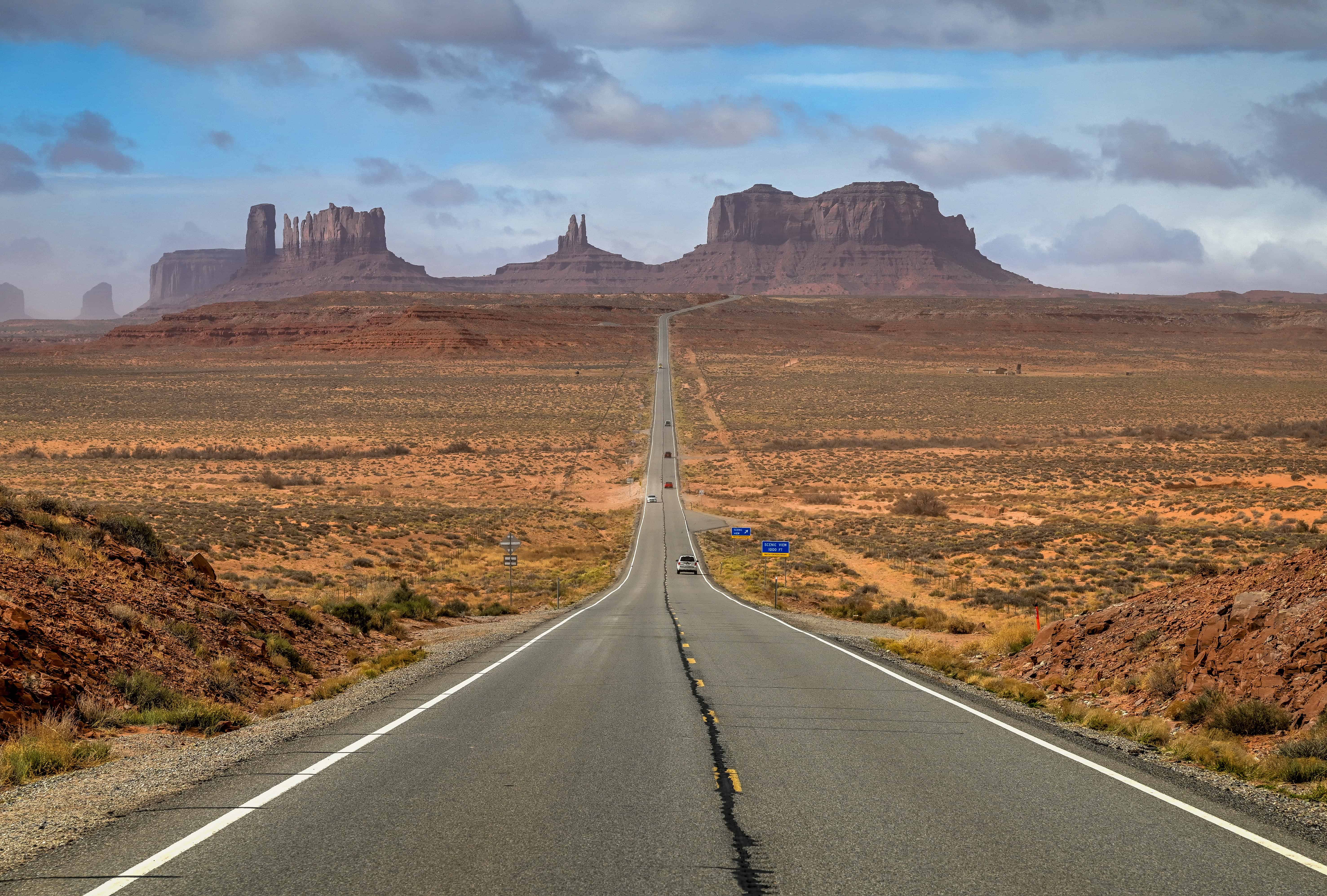
Forrest Gump Point – Just north of Monument Valley, this famous roadside viewpoint marks the spot from the 1994 film Forrest Gump where the title character ends his cross-country run. The long stretch of U.S. Highway 163 perfectly frames the towering buttes of Monument Valley in the distance, one of the most iconic photo ops in the Southwest.
Goosenecks State Park – Overlooking a dramatic series of entrenched river meanders, this viewpoint reveals one of the best examples of an “entrenched meander” in North America. The San Juan River twists nearly six miles through a canyon only 1.5 miles wide. A short detour from the highway leads to a simple viewpoint with breathtaking depth and scale.
Bluff Fort Historic Site – In the small town of Bluff, this well-preserved pioneer fort and interpretive site tells the story of the Mormon settlers who established the community in the late 1800s. Walk through replica cabins and exhibits that bring the frontier era to life.
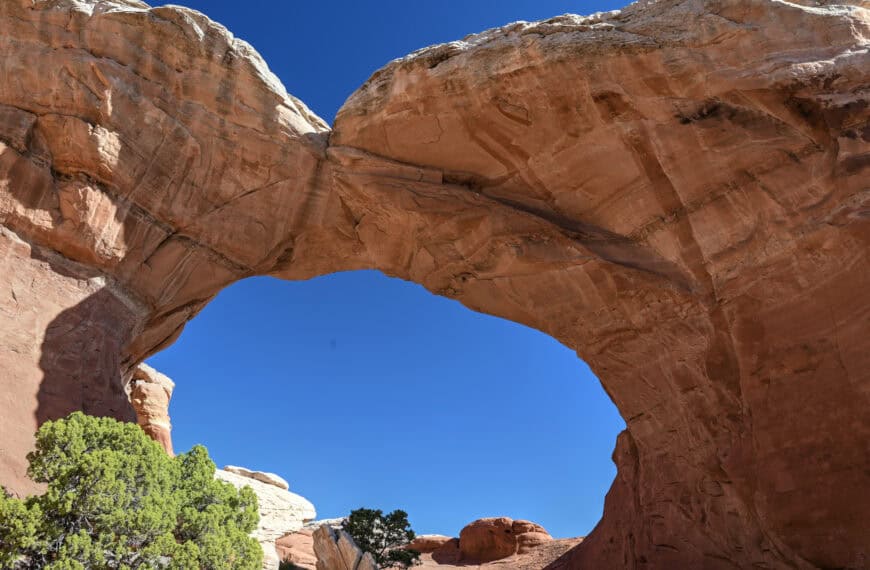
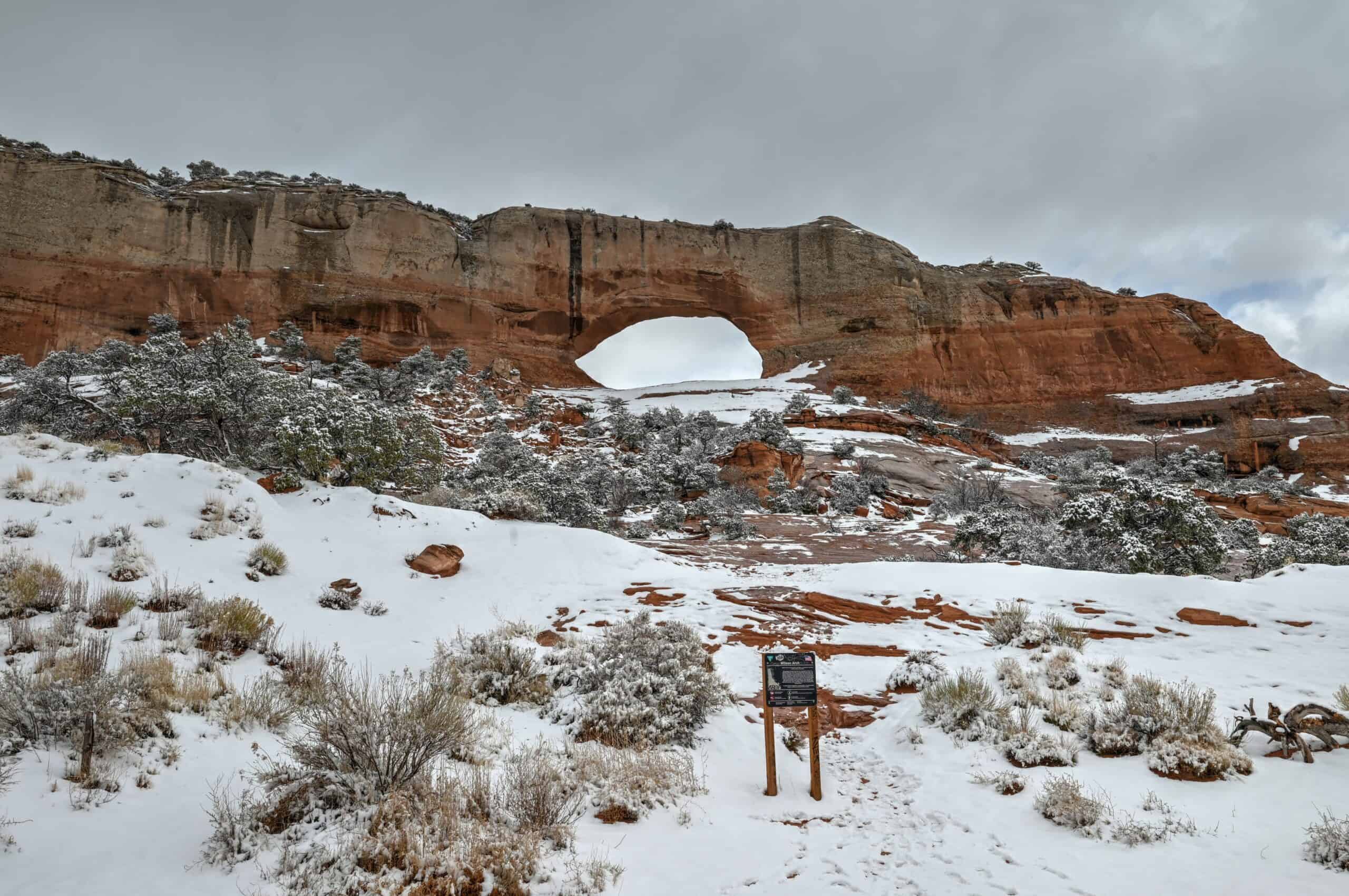
Wilson Arch – Located right off U.S. Highway 191, about 25 miles south of Moab, this graceful sandstone arch spans 91 feet and rises 46 feet high. It’s easily visible from the roadside, and a short, steep scramble offers an even closer view, perfect for a quick photo stop or leg stretch.
Spanish Valley Vineyard & Winery – Just minutes before reaching Moab, this small, family-owned winery offers tastings and scenic views of red cliffs and green fields. It’s a peaceful final stop to unwind after a day of desert driving.


Disclosure: This page (Best Stops and Things to See Between Monument Valley and Moab) may contain product affiliate links. At no additional cost to you, we may receive a commission for purchases made through these links. More details can be found on our disclosure and policies page.
How Long Is the Drive Between Monument Valley and Moab?
If you drive directly from Monument Valley to Moab via U.S. Highway 163 and Highway 191, the trip covers about 150 miles (240 km) and takes roughly 2.5 to 3 hours without stops.
This route is both the most direct and the most scenic, passing through some of the most iconic red rock landscapes in the American Southwest, including the dramatic mesas of Monument Valley, the wide-open desert around Mexican Hat, and the sculpted canyons near Bluff and Wilson Arch.
While you can complete the drive in a single morning or afternoon, it’s worth setting aside at least a few more hours, and ideally close to a full day (6-7 hours including stops), to enjoy the views, take photos, and explore short detours like Goosenecks State Park.
This guide is designed for travellers who want to enjoy the main highlights along the route in a relaxed, one-day journey. It includes recommendations for the best scenic stops, photo viewpoints, and short hikes between Monument Valley and Moab. We also mention a few attractions along the way that either require significantly more time or lengthy detours (such as the Needle District of Canyonlands National Park and Bears Ears National Monument), while noting that these are better suited to a two-day itinerary between Monument Valley and Moab.
If you need to book a rental vehicle for your roadtrip, we highly recommend using Discover Cars to get the best rates on your rental in Utah, Nevada and Arizona.
We also highly recommend Airalo (eSIM card) for your connectivity needs when travelling abroad. Airalo is the world’s first and largest eSIM store with eSIM plans for 200+ countries and regions worldwide.
Highways 163 & 191 – Driving Considerations
Altitude (and Weather) Changes
The route between Monument and Moab via Highways 163 and 191 rivals the spectacular route between Bryce Canyon and Moab via Highways 12 and 24 as one of the most scenic drives in the American Southwest. While the elevation changes are not as dramatic as those on Utah’s Scenic Highway 12, they are still significant enough to impact weather and driving conditions.
The route ranges from 4,000 ft (Moab) to over 7,000 ft (Monticello), with Monument Valley sitting in between at about 5,200 ft. If travelling north, you’ll first ascend nearly 2000 feet into cooler high-elevation conditions, only to then quickly descend 3,000 ft into warmer desert air.
Fuel Stops
Gas stations are few and far between, so it’s best to fill up when you get the chance.
Reliable fuel stops include:
Goulding’s Lodge – a short 5-minute detour off the main highway, across from the Monument Valley park entrance.
Mexican Hat – a small but convenient stop roughly 25 minutes north.
Bluff – another 25 minutes beyond Mexican Hat.
Blanding – a larger town 30 minutes north of Bluff, with several gas stations.
Monticello – 20 minutes further north, also has several gas stations.
After Monticello, there’s a stretch of 55 miles (about an hour) without a gas station until you reach the final destination, Moab, where you’ll find plenty of gas stations, as it’s the largest town along this itinerary.
Cell Service
Cell coverage is limited or nonexistent across much of the route.
Download offline maps (Google Maps) before starting your drive.
Road Safety
Highways 163 and 191 are fully paved and suitable for all vehicles. The roads are generally well-maintained, though you’ll encounter occasional steep grades and blind curves.
Side routes such as Valley of the Gods Road are unpaved and may require high-clearance or 4WD vehicles, especially after rain.
The open desert may seem empty, but deer, cattle, and even wild horses sometimes cross the road, especially around dawn and dusk. Drive cautiously in low light, and avoid travelling after dark if possible, as the region is remote and poorly lit.
Best time of year to drive
This route is enjoyable year-round, but spring (March–May) and fall (September–October) bring the most comfortable conditions, with daytime highs between 65–80°F (18–27°C) and clear skies.
In summer, temperatures can soar, so plan early morning departures and carry extra water.
Winter is typically mild but can bring chilly mornings and occasional snow flurries on the northern end near Monticello.
We’ve personally experienced how quickly conditions can change along this route. On a mid-March drive, we left Monument Valley in the late morning with temperatures in the low 50s °F (around 11°C). As we climbed toward Blanding and Monticello, we encountered snow flurries and noticeable accumulation near Wilson Arch.
By the time we reached Moab, which is only 25 miles north of Wilson’s Arch but 2000 feet lower in elevation, temperatures jumped into the low-to-mid-60s °F (15–18°C) without any sign of snow, as if we were in a completely different season.
Best Stops Between Monument Valley and Moab
The following attractions are listed from south to north, in the order you’ll encounter them when traveling from Monument Valley to Moab.
Forrest Gump Point
(Link to Google Maps) – Just north of the Navajo lands on U.S. 163 (~mile marker 13) near Mexican Hat, this roadside pull-out marks the fictional endpoint of Forrest’s cross-country run in the 1994 film.
Why stop here: The alignment of the road with the distant Mittens buttes creates a perfect “end-of-the-movie” moment, and one of the most iconic photos in Utah.
What you’ll find: A paved pull-out area on either side of the highway, where visitors stop for a quick selfie or to soak in the sweeping desert vista. Use caution when standing in the road for photos; it’s still a highway with traffic.
On your way to the Forest Gump viewpoint pullout, you’ll come across several other pullouts, each offering fantastic photo opportunities as well.
Time required: 5–10 minutes to pull in and snap a few shots.


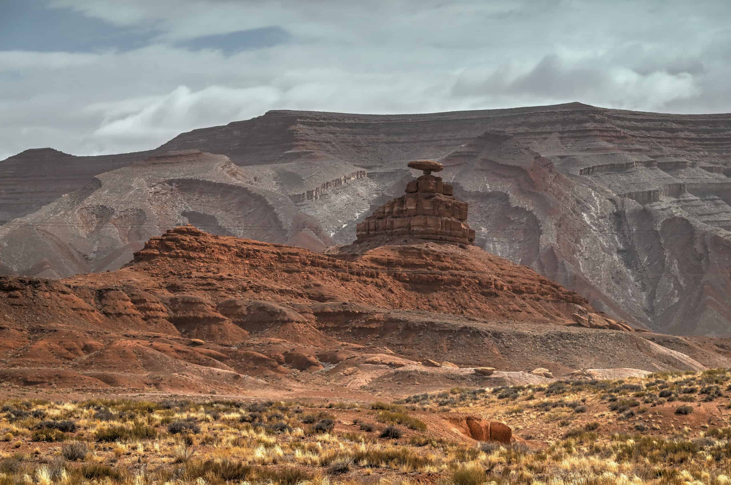
Mexican Hat Rock
(Link to Google Maps) – This striking rock formation resembles an upside-down sombrero sitting atop a slender pedestal of shale and siltstone.
Why stop here: It’s a quick-and-easy roadside detour and a quirky example of desert erosion and balancing rock formations.
What you’ll find: Pull over on the highway for a clear view, or take the short side road to get a closer perspective.
Time required: 15-30 minutes.
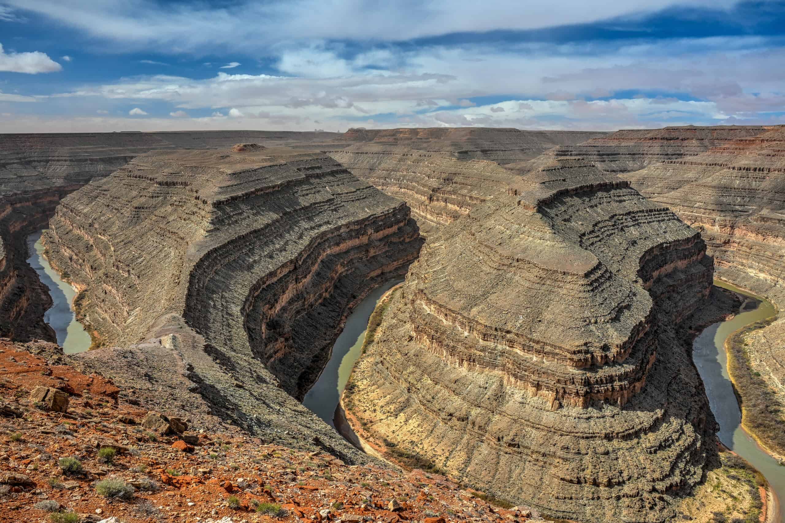
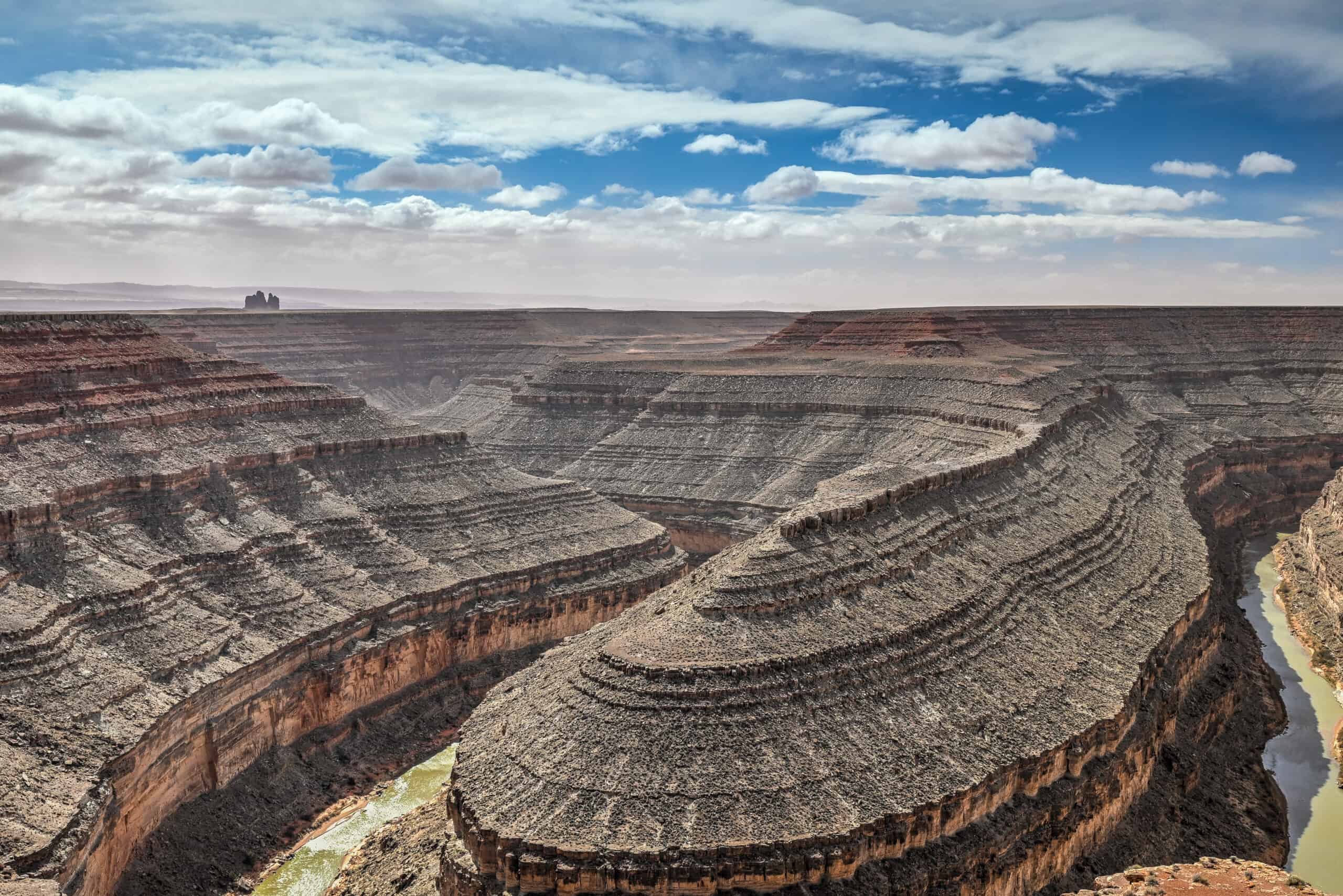
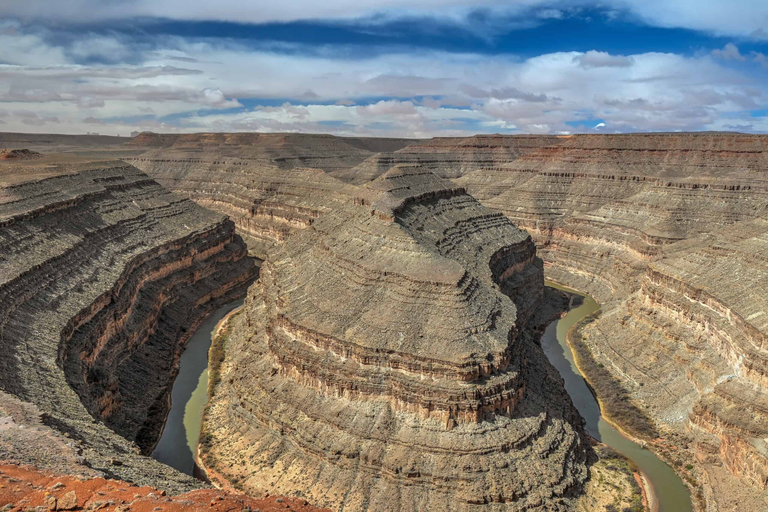
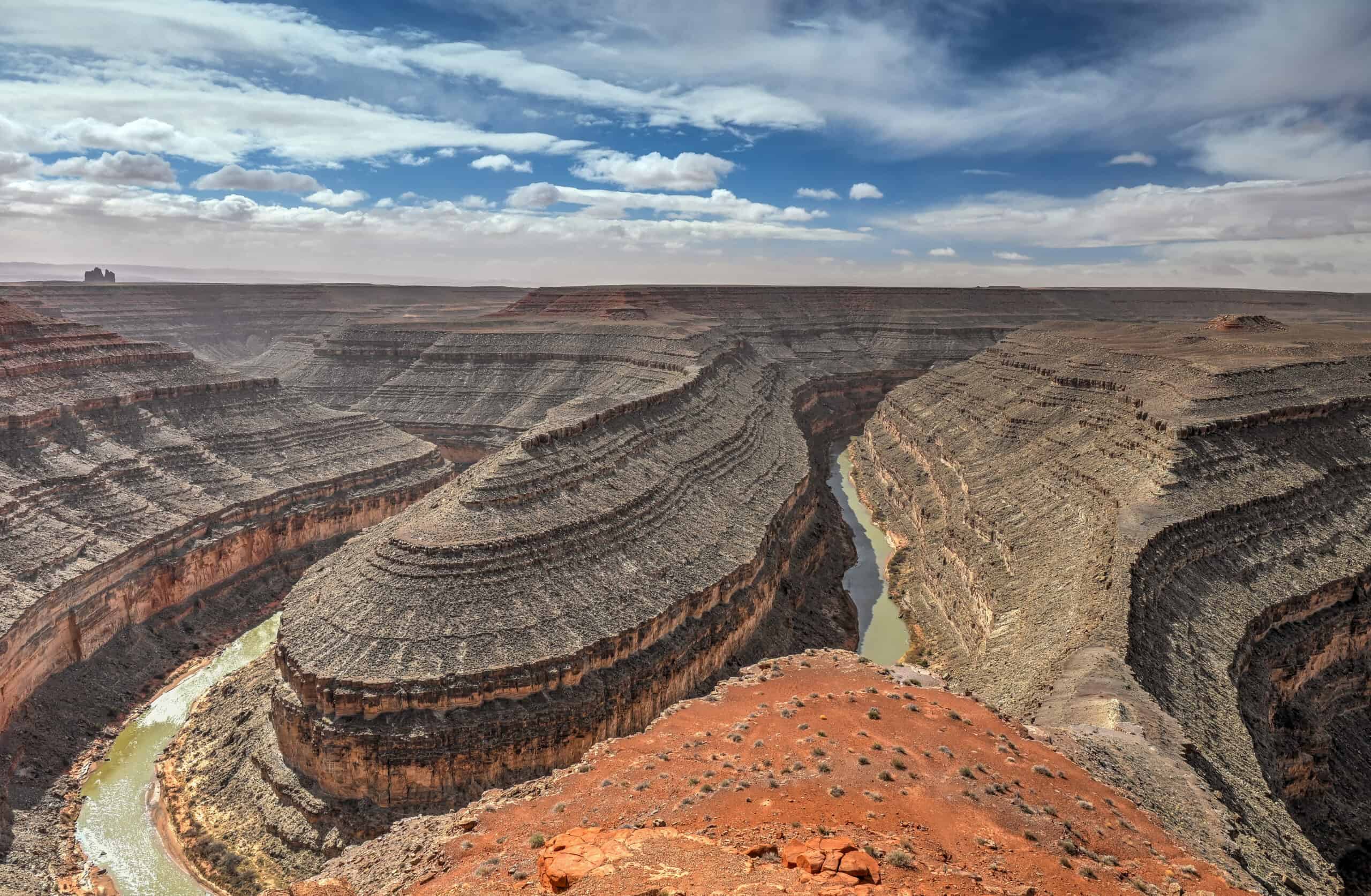
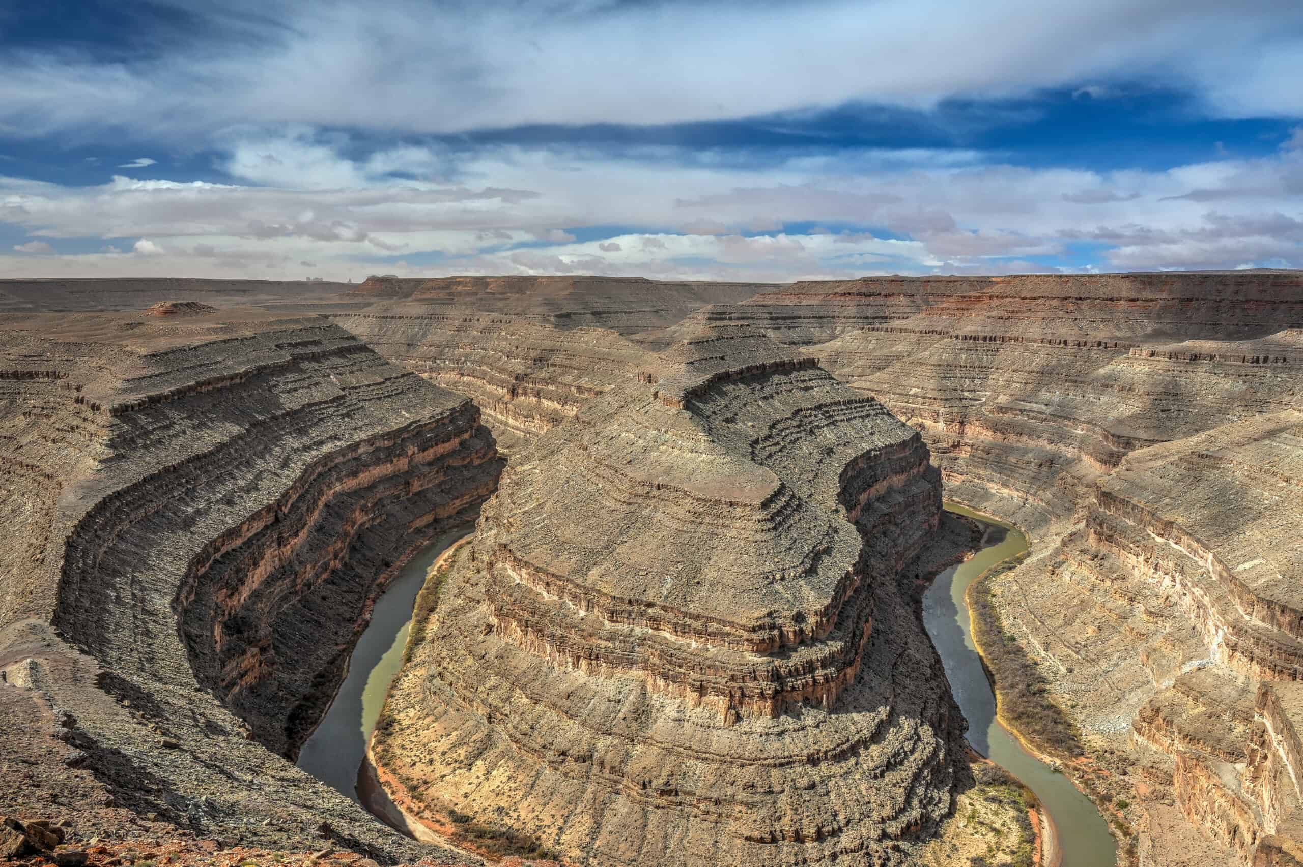
Goosenecks State Park
(Link to Google Maps) – Here you’ll find one of the most dramatic entrenched meanders in North America: the San Juan River twists six miles through a canyon just one and a half miles across.
Why stop here: The dizzying depth and jaw-dropping scale of the canyon are an unforgettable contrast to the wide-open valley views typical of the region. It’s a great spot to enjoy moments of solitude as well, as we almost had the place to ourselves during our visit, a sharp contrast to how busy Monument Valley was.
What you’ll find: Located off UT 261 between Mexican Hat and Bluff, a paved access road leads to a small parking lot and overlook with bare-edge cliffs and no barriers. Be alert at the edge – it can be particularly windy.
Toilets and a small campground are adjacent to the car park.
Time required: 15 – 20 minutes
Tips: Cellular signal is very weak and occasionally the credit card payment system won’t work, so it’s a good idea to carry a bit of cash with you (As of late 2025, day-use fee of $5 per private vehicle (up to 8 people)).


Valley of the Gods & Moki Dugway
(Link to Google Maps) – Often described as the quieter sibling of Monument Valley, Valley of the Gods delivers a 17-mile scenic dirt and gravel road that winds through lonely red-rock buttes, slender spires, and open desert immensity. It’s a place where the silence is part of the landscape: no crowds, no facilities, just classic canyon country vibes. At the western end of the loop, the road links seamlessly into the Moki Dugway: a jaw-dropping slice of road engineering where Highway 261 suddenly transforms into a steep, switchbacking gravel climb that scales 1,200 ft up the Cedar Mesa cliffs. Built in the 1950s to haul uranium ore, it’s still a feat to experience, especially as panoramic viewpoints reveal superb aerial perspectives over the entire Valley of the Gods below.
Why stop here: Infinite skies, towering formations, and solitude, paired with a thrilling drive that feels like a hidden national-park-quality overlook.
What you’ll find: Valley of the Gods: wide gravel road, by-yourself scenery, no services. Moki Dugway: three steep miles, 1,200-ft climb, multiple pull-outs, and a viewpoint. A high-clearance vehicle is a must, and 4WD is highly recommended, particularly after rain.
Although the Valley of the Gods road isn’t a loop, you can avoid backtracking by creating a loop via Highways 261 (where the west entrance is) and 63 (where the east entrance is).
Time required: 1h30–2h30 hours (depends on how many stops and ease of driving) to complete the Valley of the Gods loop. Another 30 minutes if you want to ascend (and then descend the Moki Dugway).
Tip & Alternate route: Instead of descending the Moki Dugway the same way you came up, you can continue north on Highway 261 (fully paved after the switchbacks), then turn east on Highway 95 to reconnect with US-191 south of Blanding. The total time is roughly the same (~50–60 minutes) as backtracking along 261 and heading back onto 191 near the east entrance of Valley of the Gods road.
Advantage of the alternate route: You’ll naturally pass by some of the Bears Ears National Monument highlights (described further below) without having to take an additional detour to visit them, and you’ll traverse more diverse scenery such as the Cedar Mesa forestland.
Disadvantages of the alternate route: You will bypass the Bluff Historic Site (described next), and you will go the next 50 miles without crossing a gas station (be sure to top up beforehand).
Bluff Fort Historic Site
(Link to Google Maps) – In the small town of Bluff, this reconstructed fort-and-settler village memorializes the Mormon pioneers who ventured into the high desert in the late 1800s.
Why stop here: A gentle cultural and historical interlude that complements the geological dramas of the canyon country.
What you’ll find: Restored pioneer cabins, interpretive displays, and stories of daily frontier life, plus a spacious visitor center and gift shop.
Time required: 30-40 minutes to check out the site and a quick break.
Coffee break option: Looking for a caffeine boost or a quick snack? Twin Rocks Café (link to Google Maps) is a convenient stop before continuing your route and also serves a variety of American and Navajo cuisine (including the Navajo bread local specialty).


Natural Bridges National Monument + Bears Ears Archaeological Stops
Sitting within the culturally rich Bears Ears region west of Blanding, this trio (Natural Bridges National Monument, House on Fire, and the Butler Wash Interpretive Site) blends dramatic canyon scenery with deep Indigenous history.
Why Visit:
–Bridges National Monument (link to Google Maps): Scenic loop drive with overlooks of three colossal stone bridges ( Sipapu, Kachina & Owachomo) formed by ancient waterways. Short trails lead closer to the spans and offer cultural context.
–House on Fire (link to Google Maps): A ~2 mi round-trip hike to a photogenic ancient granary where midday light ignites the cliff above in fiery orange tones.
–Butler Wash Interpretive Site (link to Google Maps): A short walk to a viewpoint overlooking a cliff-dwelling tucked within a canyon alcove, with signage explaining the ancestral village.
What to expect: A deeply rewarding cultural detour, but it adds several hours and a reroute via Highway 95. Best for travellers spreading the journey over two days; not ideal if aiming to drive from Monument Valley or Moab in a single day.
Time required: 3–6 hrs, depending on the specific trails and interest.
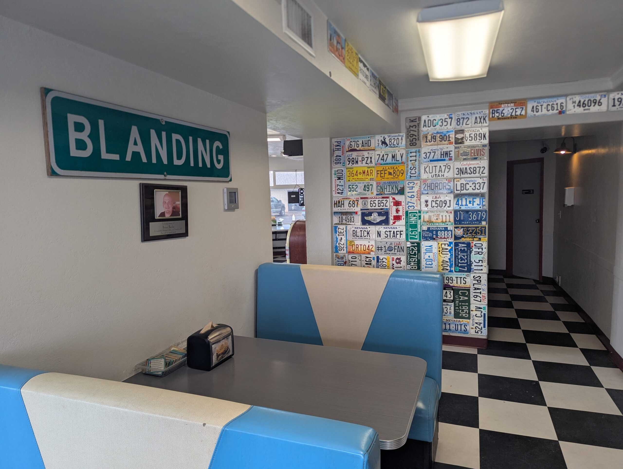
Blanding
For a change of pace, the town of Blanding offers two compelling museum stops: the Dinosaur Museum (link to Google Maps) with full-sized dinosaur skeletons, and the Edge of the Cedars museum (link to Google Maps) focused on Ancestral Puebloan archaeology.
Why stop here: A chance to sit, learn, and cool off, ideal for matching indoor time with desert driving.
What you’ll find: Both museums include exhibits, restrooms, and a comfortable break from the road.
Time required: At least 30 minutes for each.
Lunch break option: Looking for a bite nearby? Patio Diner (link to Google Maps) is a long-standing hamburger restaurant in Blanding, Utah, known for serving fresh burgers since 1959 and offering a vintage-style diner experience
Canyonland National Park – Needles District
(Link to Google Maps) – Southeast of Moab and accessible via UT 211, the Needles District sits in a remote corner of Canyonlands National Park, defined by slender sandstone spires, maze-like canyons, and rugged desert terrain. The district takes its name from the colorful Cedar Mesa Sandstone “needles” that dominate the landscape.
Why Visit: The park offers a range of experiences: short walks such as the Pothole Point or Slickrock Trails, and more ambitious hikes like the Chesler Park loop or Druid Arch trek. You’ll also find Fewer crowds compared with other districts of the park, perfect for those who want quieter wilderness and deeper immersion.
What to expect: Remote roads, dramatic elevation changes, and longer travel time make this best for those willing to linger rather than rush through. You’ll want at least several hours, ideally half a day or more, to fully appreciate the sweeping scenery and unique rock formations. Even if you were to only want a quick glimpse of the area, you would be looking at a detour of at least 45 minutes each from Highway 191.
Time required: A few hours at minimum to explore the roadside viewpoints and a few shorter trails (Driving the main park road alone takes ~1 hr 20 min round-trip).
Wilson’s Arch
(Link to Google Maps) – Just 25 miles (40 km) south of Moab, Wilson Arch offers a striking sandstone arch next to Highway 191. It has a span of 91 feet and a height of 46 feet. It is visible from the road to the east, where there are turnouts with interpretive signs
Why stop here: No detour needed: simply pull off the highway for a short walk and a dramatic arch photo with minimal effort.
What you’ll find: A small parking area, a brief footpath, and signage. No facilities beyond basic parking.
Time required: 10 – 15 minutes.


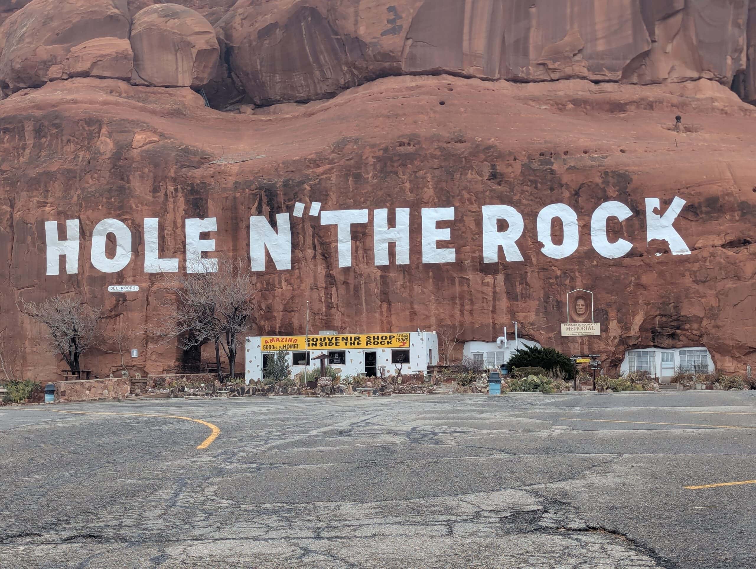
Hole ‘N’ The Rock
(Link to Google Maps) – A delightfully quirky roadside stop for those who want to stretch their legs again: a 5,000 sq ft home carved into a sandstone cliff, and plenty of “oddities” to explore. Albert Christensen began creating the home in 1940, and his family was able to move in 1952. The site was opened to public tours after Albert’s death in 1957.
What you’ll find: A short guided tour of the rock-carved home: 14 rooms, pillars, rock bathtub, chimney: a wild example of DIY engineering (but no pictures are allowed to be taken from inside the house).
You’ll also find metal art sculptures, a small petting zoo, a trading post, a general store, souvenirs, and washrooms.
Time required: 15 – 45 minutes (really depends on how long you want to linger).
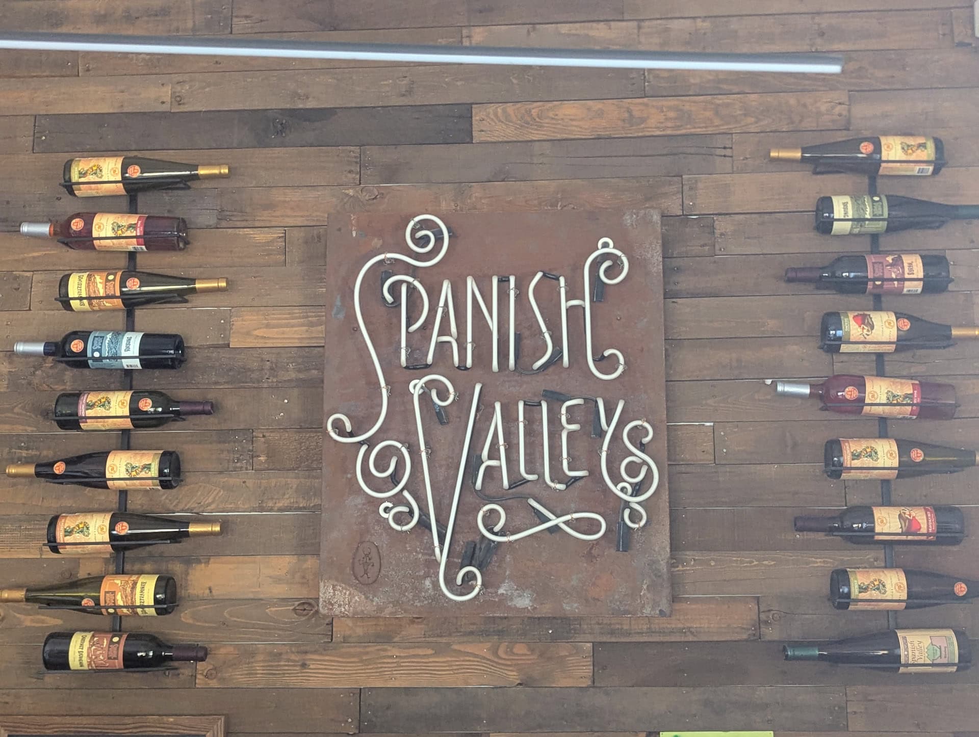
Spanish Valley Vineyard & Winery
(Link to Google Maps) – Just outside Moab, Spanish Valley Vineyard & Winery is one of Utah’s few estate-grown wineries. Founded in 1979, it cultivates its own grapes on site and offers tastings in a relaxed, scenic setting.
Why stop here: A peaceful way to unwind after long desert drives, a softer change of pace from the region’s rugged red-rock adventures.
What you’ll find: A selection of local wines, an indoor tasting room and shaded outdoor seating area, and sweeping views of the surrounding red rock.
Time required: 45-60 minutes for a tasting and rest. No reservations needed.
Winery website.
The Roads: Scenic Highways 163 & 191
As if the many attractions along the route weren’t enough, the drive itself is part of the adventure. The landscapes visible right from the car window are as stunning as the destinations they connect. No extra words are really needed here; just a few photos will tell the story best.


Our Suggested One-Day Itinerary: From Monument Valley to Moab
If you tried to see everything listed in this guide, you could easily spend several days exploring the region: there’s that much to see along Highways 161 and 193 and their offshoots. But for those with just a single day to make the journey, it’s still possible to experience some of southern Utah’s most spectacular scenery without needing a 4WD vehicle or venturing down remote dirt roads.
This itinerary highlights what we think are the most rewarding stops for a one-day trip from Monument Valley to Moab, focusing on locations that are scenic, accessible, and close to the main route. It’s exactly the route we followed ourselves, and it works just as well in reverse for those travelling from Moab to Monument Valley.
Morning: Forest Gump Point to Blanding
Start your day heading north on US-163. The drive from Monument Valley to Blanding is about 75 miles (1 hr 15 min without stops), but allow time to take in several great viewpoints and cultural stops.
Your first pull-off is Forrest Gump Point, framed by the iconic Mitten Buttes rising in the distance, a perfect place for a classic road photo. Continue north toward Goosenecks State Park, where a short detour reveals one of the most impressive entrenched river meanders in the Southwest: the San Juan looping in tight horseshoe bends hundreds of feet below.
Farther north in the small town of Bluff, Bluff Fort Historic Site offers a quick but interesting look into the pioneer history of the region, a nice counterpoint to the desert scenery.
By late morning, arrive in Blanding for lunch at Patio Diner, a reliable stop with comfort food and a chance to refuel before a full afternoon of exploring.
Time required: Plan for about 3 hours for this morning section (plus extra time for lunch).
Optional:
–Mexican Hat Rock: a quirky roadside photo-op you’ll pass along the way; fun but not a trip-maker.
–Valley of the Gods: stunning scenery similar to Monument Valley, reached via a rough dirt road. Only recommended if: you have 2 extra hours, a high-clearance and/or 4WD vehicle, and dry road conditions.
Afternoon: Blanding to Moab
The second leg to Moab is another 75 miles (1 hr 15 min without stops), but there’s plenty worth seeing en route.
Before leaving Blanding, consider visiting one (or both!) of the town’s museums, the Dinosaur Museum or Edge of the Cedars State Park Museum, for some welcome A/C if travelling during the summer heat and engaging exhibits on paleontology and ancestral Puebloan history.
Back on US-191, you’ll hit the longest uninterrupted stretch of the journey (50 miles), framed by rolling high-desert terrain. Eventually, you’ll reach Wilson Arch, a striking sandstone arch right off the highway, a quick, easy pause to stretch your legs.
Continue north to the quirky roadside attraction Hole ‘N’ The Rock, that impressive 5,000-sq-ft home carved into sandstone with photo ops that verge on the bizarre but memorable for sure!
Time required: Again, plan for about 3 hours for this morning’s section.
Optional: For those who enjoy wine, the Spanish Valley Vineyard & Winery is a fun and unexpected treat near Moab: a tasting experience amid desert red rock views. A great way to unwind if time allows.
Total Time Estimate for This One-Day Itinerary:
With this suggested itinerary (not including the optional itinerary attractions or a lunch stop), you can expect about 3-4 hours of sightseeing, plus roughly 2h30-3 hours of total driving between Monument Valley and Moab. It makes for a full but perfectly manageable day, and one of the most memorable road trips in Utah.
The Destinations: Monument Valley and Moab (Arches, Canyonlands)
Monument Valley Navajo Tribal Park
Monument Valley marks the southern starting point of this iconic Southwest journey, an unforgettable landscape of towering sandstone buttes rising from a wide, open desert floor. Straddling the Utah–Arizona border on Navajo Nation land, the valley has appeared in countless films and is often seen as the visual symbol of the American West.


If you’re short on time, you can still experience the best of Monument Valley in a few hours. Begin at the Visitor Center overlook, where the Mittens and Merrick Butte form one of the most famous silhouettes in the region. From here, the 17-mile Valley Drive leads you closer to the monoliths, with frequent pullouts for photos and Navajo-run craft stalls.
For more information, be sure to check out our Monument Valley visiting guide, covering everything from entry fees and scenic drives to the best viewpoints, tours, and nearby places to stay.
Moab (Arches & Canyonlands National Parks)
At the opposite end of this route lies Moab, the adventure capital of southeastern Utah and gateway to two of the state’s “Mighty 5” national parks: Arches and Canyonlands.
Arches National Park is just minutes from downtown Moab and boasts more than 2,000 natural stone arches, along with soaring spires and balanced rocks. The park’s scenic drive connects short, photogenic hikes like Delicate Arch, Double Arch, and The Windows, making it easy to explore even if you’re short on time.
Canyonlands National Park, by contrast, feels wilder and more expansive. The Island in the Sky District, about 40 minutes from Moab, offers jaw-dropping overlooks like Mesa Arch and Grand View Point, where vast canyons stretch to the horizon.
Moab itself is a vibrant desert town filled with cafés, gear shops, and laid-back lodges, an ideal base for exploring eastern Utah’s red-rock country. After days of hiking or driving, you can unwind with a sunset drink overlooking the Colorado River or stroll through the downtown art galleries.
Driving Between Monument Valley and Moab – Frequently Asked Questions
How long does it take to drive between Monument Valley and Moab?
If you drive directly from Monument Valley to Moab via U.S. Highway 163 and Highway 191, the trip covers about 150 miles (240 km) and takes roughly 2.5 to 3 hours without stops. However, with viewpoints, small towns, and park visits along the way (for example, at Goosenecks State Park or Wilson Arch), most travellers spend a full day on the road.
Are there gas stations between Monument Valley and Moab?
Gas stations are sporadic but reliable if you plan ahead. You’ll find the most options along the route in Blanding.
Is the route safe to drive?
Yes. The major connecting roads are paved and in good condition (such as US-191 and US-163). But keep in mind: some scenic detours (such as the Valley of God road) are unpaved and may require high-clearance/4WD. Check the conditions if you plan to drive on those roads.
Will I have cell service during the drive?
Expect very limited or no mobile service in stretches between the major towns and through tribal park lands or remote canyon areas. It’s a good idea to download offline maps ahead of time or ensure someone knows your route.
When is the best time of year to do this drive?
The most comfortable months are April through October, when the weather is mild and road conditions are generally good. In winter, some remote roads may be icy or muddy; in high summer, the desert heat can be intense.
Can I do this drive in an RV or trailer?
Yes. Many travellers in RVs or trailers take this route. Stay on paved main roads for safety. If you plan to venture on gravel loops or high-clearance detours, make sure your vehicle is suitable, and conditions are good.
What are the best scenic overlooks or stops along the route?
A few top ones to consider:
-Forrest Gump Point (US-163 north of Monument Valley)
-Goosenecks State Park
-Wilson Arch
Where can I stop for food or coffee along the way?
Towns en route, like Bluff and Blanding, offer the most lunch/coffee options. The Twin Rocks in Bluff is great if you have a late start to the day or just for a coffee break, whereas the Patio Diner in Blanding is right at the midway point of the proposed itinerary.
Are there unique roadside detours worth checking out?
Yes. If you have the time and a suitable vehicle, you might consider detours to places like Valley of the Gods (requires more time and sometimes high clearance) or other canyon-view loops. If you’re aiming just to connect Monument Valley to Moab in one go, you can stick to the main route and still see fantastic scenery.
Explore More Utah Roadtrip Guides
Continue exploring Utah with these detailed guides:
Best Stops and Attractions Between Vegas and Zion
Best Stops and Attractions Between Bryce Canyon and Moab
Best Stops and Attractions Between Zion and Bryce Canyon
Photography Gear
If you like our photography, you might be interested in some of the gear we use to shoot our travel and hiking destinations.
Camera Body – Nikon Z 6ii Fx-series Mirrorless Body
Main Lens – NIKON 24-120mm F/4G ED VR AF-S
Zoom Lens – Sigma 745-306 150-600mm f/5-6.3
Polarizing filters – Urth Circular Polarizing (CPL)
Camera Tripod – K&F Concept 64-inch Camera Tripod
Mini-tripod – Lammcou Flexible Camera Tripod
Camera/hiking backpack – Vanguard Alta Rise 48 Backpack
Universal Travel Adapter – VYLEE Universal International Power Travel Plug
Other Travel Essentials
Travel Insurance
SafetyWing is a travel insurance company that offers comprehensive coverage for travellers. Includes Medical Insurance and Travel Insurance. Primarily geared towards long-term travellers, digital nomads, and expats.
e-Sim cards
Airalo is the world’s first and largest eSIM store with eSIM plans for 200+ countries and regions worldwide. With Airalo eSIMs, travellers can get connected the moment they land at their destination and avoid nasty data roaming charges
eSIMS are a sustainable alternative to single-use SIM cards – they are 100% digital, require less energy to produce and be re-used rather than disposed of.
Car Rentals
Discover Cars is our go-to website for car rentals. We almost always find our preferred rate there.
Transfer from Airport
Welcome Pickups is our favourite private transfer service, which you can pre-book at a fixed price. Currently available in 220 cities all over the world (mostly in Europe, but with several major cities in Asia, the Middle East and the US).
Kiwitaxi is another private transfer service – we haven’t tried it yet, but it’s currently available in a few more countries (102 as of 2024).
Hotels and Accommodations (coming soon)
Photography Prints
If you found this blog useful, you can help support our blog by purchasing low-cost digital prints. Printed physical prints are also available for purchase.


—–
Well, that wraps it up! We hope you enjoyed our Utah Road Trip Guide on the Best Stops on the Drive from Monument Valley to Moab and that it will prove useful for planning your trip.
—–
You might also be interested in these related pages: