The drive between Bryce Canyon National Park and Moab via Highways 12 and 24 is often called one of the most scenic road trips in the American Southwest, and for good reason. Spanning roughly 275 miles (440 km), the route winds through a kaleidoscope of red rock formations, slickrock canyons, alpine forests, and sweeping desert plateaus. Every curve in the road reveals another breathtaking vista or unexpected stop worth exploring. Along the way, you’ll pass through some of Utah’s most iconic landscapes, including Grand Staircase–Escalante National Monument, Capitol Reef National Park, and Goblin Valley State Park. The drive connects several of Utah’s “Mighty 5” parks and countless hidden gems in between, making it a journey where the road itself is just as memorable as the destinations. In this guide, we’ve gathered the best stops, viewpoints, and short hikes along Highways 12 and 24, perfect for travellers who want to make the most of the drive between Bryce Canyon and Moab, whether they have a full day or just a few hours to explore.
Best Stops Between Bryce Canyon and Moab – At a Glance
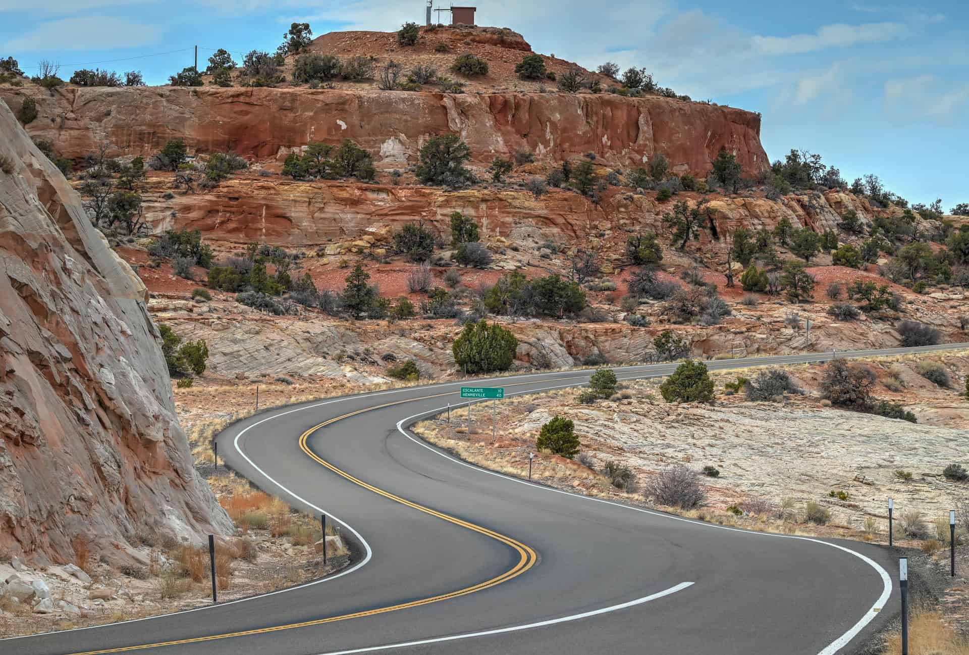
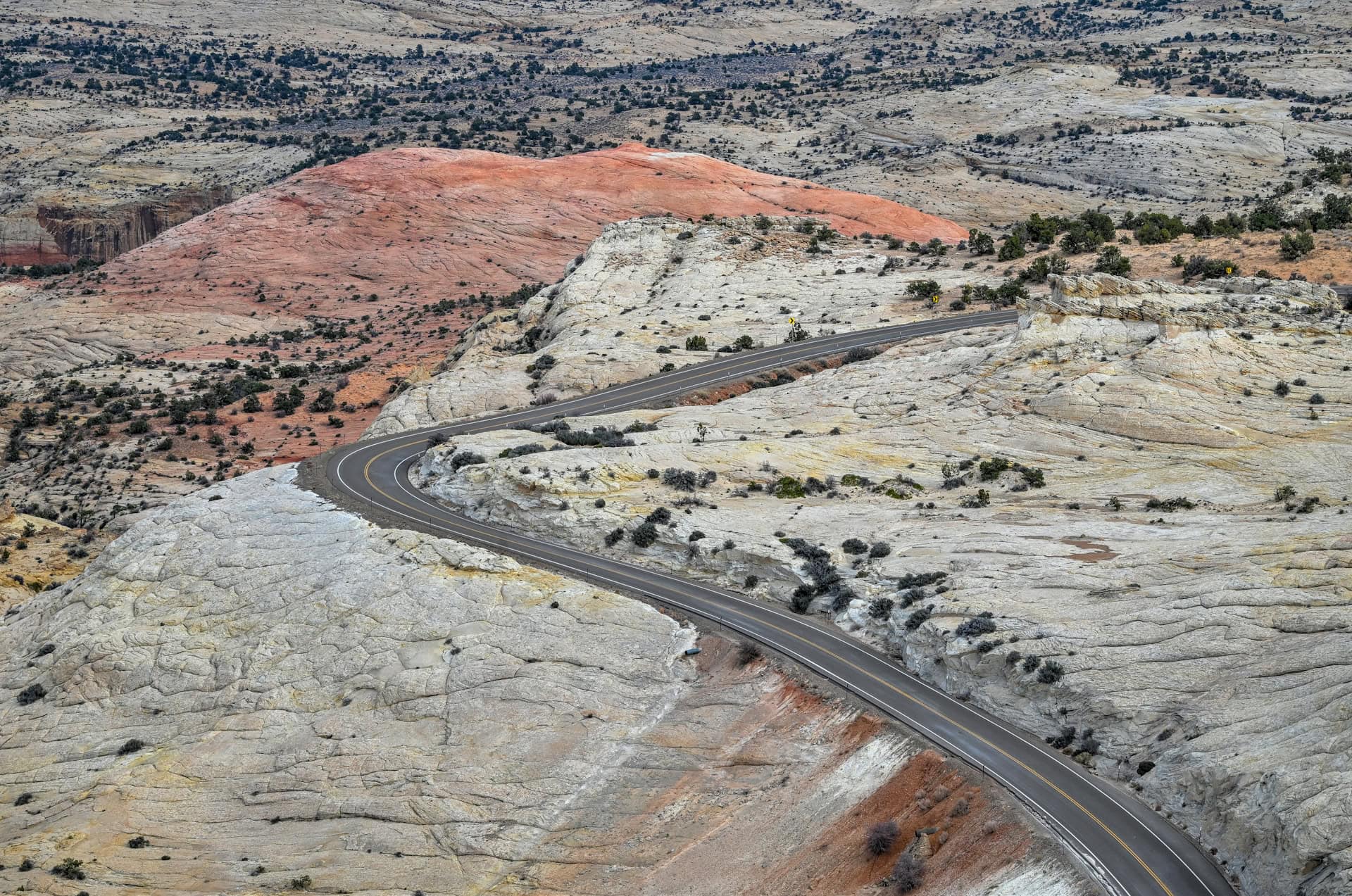
Scenic Highway 12 – Utah’s Most Beautiful Drive – Stretching almost 120 miles from Bryce Canyon to Torrey, Highway 12 is often ranked among America’s most beautiful roads. The route winds through red canyons, alpine forests, slickrock ridges, and high desert mesas, offering one jaw-dropping view after another. It’s a drive where the journey truly rivals the destinations.
The Hogback & Iconic Viewpoints – One of Highway 12’s most thrilling stretches, The Hogback is a narrow ridge with steep drop-offs on both sides: no guardrails, just endless views over canyons and cliffs. Scenic pullouts like Boynton Overlook and Head of the Rocks Overlook offer incredible panoramas that perfectly capture Utah’s rugged beauty.
Charming Small Towns – Towns like Escalante, Boulder, and Torrey make perfect stops for food, fuel, or an overnight stay. Boulder’s Kiva Koffeehouse pairs great coffee with unbeatable canyon views, while Escalante serves as the gateway to the Grand Staircase–Escalante National Monument and several fantastic hiking trails.
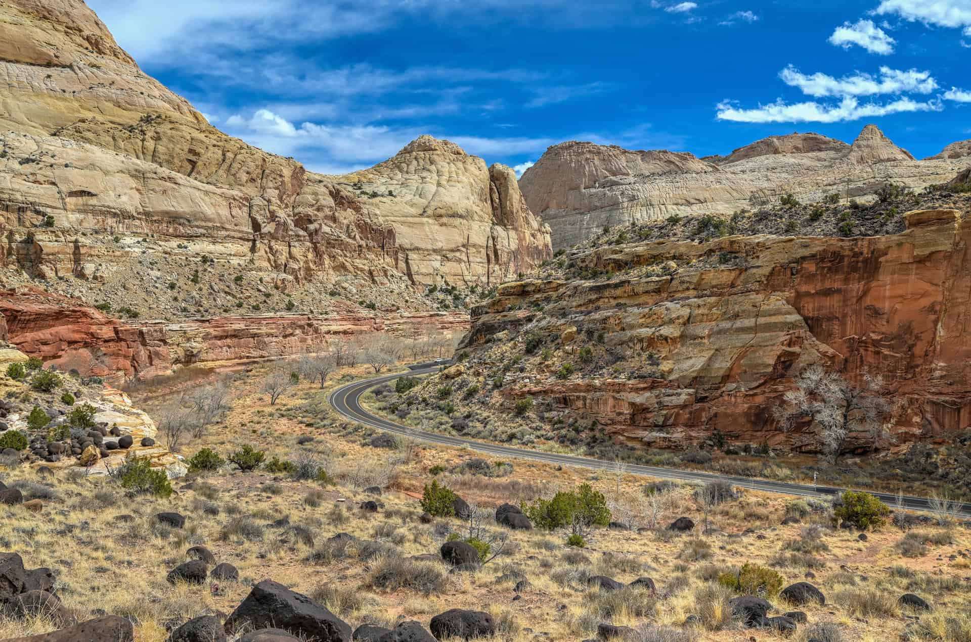
Capitol Reef National Park – Often called the hidden gem of Utah’s “Mighty 5,” Capitol Reef offers dramatic cliffs, lush orchards, ancient petroglyphs, and easy-access hikes like Hickman Bridge and Grand Wash, all conveniently located right off Highway 24.
Goblin Valley State Park – A short detour off Highway 24 leads to this otherworldly landscape of thousands of mushroom-shaped hoodoos. Compact and easy to explore in a few hours, Goblin Valley is an ideal leg-stretching stop between Capitol Reef and Moab.


Disclosure: This page (Best Stops and Things to See Between Bryce Canyon and Moab) may contain product affiliate links. At no additional cost to you, we may receive a commission for purchases made through these links. More details can be found on our disclosure and policies page.
How Long Is the Drive Between Bryce Canyon and Moab?
If you drive directly from Bryce Canyon to Moab via Highway 70, the trip covers about 250 miles (400 km) and takes roughly 4½ to 5 hours without stops. This is the fastest route: efficient for those on a tight schedule, but it skips much of southern Utah’s most spectacular scenery.
For a far more rewarding journey, we strongly recommend taking the scenic route along Highways 12 and 24, which is consistently rated one of America’s most scenic drives, combining red rock canyons, slickrock ridges, alpine forests, and high desert plateaus: a true showcase of Utah’s natural diversity.
This route passes through some of the most beautiful landscapes in the American Southwest, including Grand Staircase–Escalante National Monument, Capitol Reef National Park, and Goblin Valley State Park. It’s about 270 miles (460 km) and takes roughly 5 to 6 hours of driving time, but you’ll want to plan for at least a full day (8–10 hours total) to account for photo stops, short hikes, and detours.
While you could easily spend a full week exploring the countless attractions along this route, from hidden slot canyons and scenic overlooks to remote desert drives, this guide is designed for travellers who want to experience the main highlights over the course of a single day or two. It’s particularly useful for those connecting Bryce Canyon with Moab, which serves as the perfect base for visiting Arches and Canyonlands National Parks.
If you’d like to break the journey into two days, consider spending the night near Capitol Reef National Park, which sits roughly at the midway point between Bryce Canyon and Moab. This area makes an excellent overnight stop, offering scenic surroundings, great hiking, and several comfortable lodging options, which we’ll highlight toward the end of this guide.
If you need to book a rental vehicle for your roadtrip, we highly recommend using Discover Cars to get the best rates on your rental in Utah, Nevada and Arizona.
We also highly recommend Airalo (eSIM card) for your connectivity needs when travelling abroad. Airalo is the world’s first and largest eSIM store with eSIM plans for 200+ countries and regions worldwide.
Highway 12 and Highway 24 Driving Considerations
Altitude (and Weather) Changes
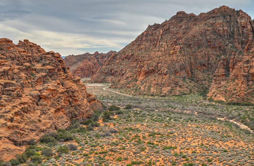
The route between Bryce Canyon and Moab via Highways 12 and 24 is one of the most scenic drives in the American Southwest, but it’s also one that requires a bit of planning. The road winds through a variety of landscapes, from high alpine forests to open desert valleys, meaning altitude changes are frequent and can exceed 4,000 feet (1,200 m) between sections. Weather can shift dramatically: cool and breezy in one spot, then hot and dry in another.
One particularly dramatic stretch lies between Escalante and Capitol Reef National Park. Within about 70 miles (roughly 1½ hours of driving), you’ll climb from 5,200 feet up to nearly 9,600 feet before descending again to around 5,300 feet. You can easily experience temperature differences of 10–15°F (5–8°C) between high and low points. This is especially important if rain is in the forecast, as cool temperatures at elevation can quickly turn precipitation to snow.
Fuel Stops
Gas stations are limited along this route, particularly between Torrey and Hanksville (50 miles / 80 km) and between Hanksville and Green River (60 miles / 95 km). Always fill up when you have the chance.
Reliable fuel stops include Escalante (45 miles from Bryce Canyon City), Boulder (25 miles farther), Torrey (another 35 miles), Hanksville (50 miles farther), and Green River (60 miles beyond Hanksville, about 50 miles from Moab).
Cell Service
Expect limited to no cell service along much of Highways 12 and 24, especially between Boulder and Torrey and throughout most of Capitol Reef National Park. Be sure to download offline maps in advance and keep any critical information saved for offline access.
Road Safety
You’ll also encounter stretches of steep grades, winding roads, and limited guardrails, especially along the Boulder Mountain summit and The Hogback, the famously narrow ridge on Highway 12 between Escalante and Boulder. While the roads are fully paved and generally safe for all vehicles, drive cautiously and take advantage of scenic pullouts to admire the views.
Avoid driving at night if possible, as lighting is minimal and wildlife crossings are common.
Speaking of which, keep an eye out for deer and open-range cattle, especially during dawn and dusk when they’re most active near the roadside.
Best time of year to drive
Highways 12 and 24 can be enjoyed year-round, but the most comfortable and scenic months are April through October. Spring and fall bring mild temperatures and vibrant landscapes, while summer offers clear skies but can be extremely hot in low-elevation desert regions.
In winter, snow and ice are common near Boulder Mountain, making driving conditions temporarily challenging. Always check the local weather before departure if travelling between November and March.
We once drove the route in late March, and while the trip was perfectly manageable, there was a fair amount of snow lining the roads through Dixie National Forest near Boulder Mountain. The temperature there hovered just above freezing, which was a stark contrast to the warm sunshine of nearby Capitol Reef.


Best Stops Between Bryce Canyon and Moab – Scenic Highway 12
Near Bryce Canyon
Mossy Cave Trail – (link to Google Maps)
If you didn’t get a chance to hike the trail during your time in Bryce Canyon National Park, this is a good time to do it, as the trailhead is outside of the park boundary and located a 5-minute drive east of Bryce Canyon City, not far from Tropic. This short and easy 0.8-mile (1.3 km) round-trip hike follows a small stream, passing a seasonal waterfall and leading to a shaded alcove known as Mossy Cave, which is filled with mosses in the summer and icicles in the winter. It’s perfect for a quick stop to stretch your legs (you can expect to spend 20-25 minutes here).
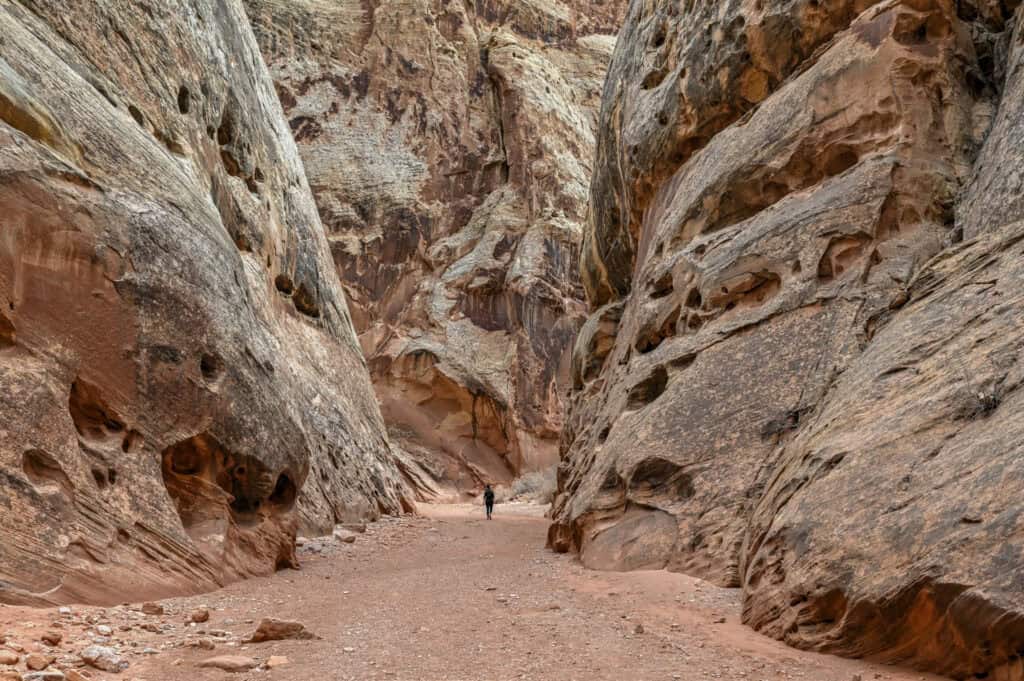
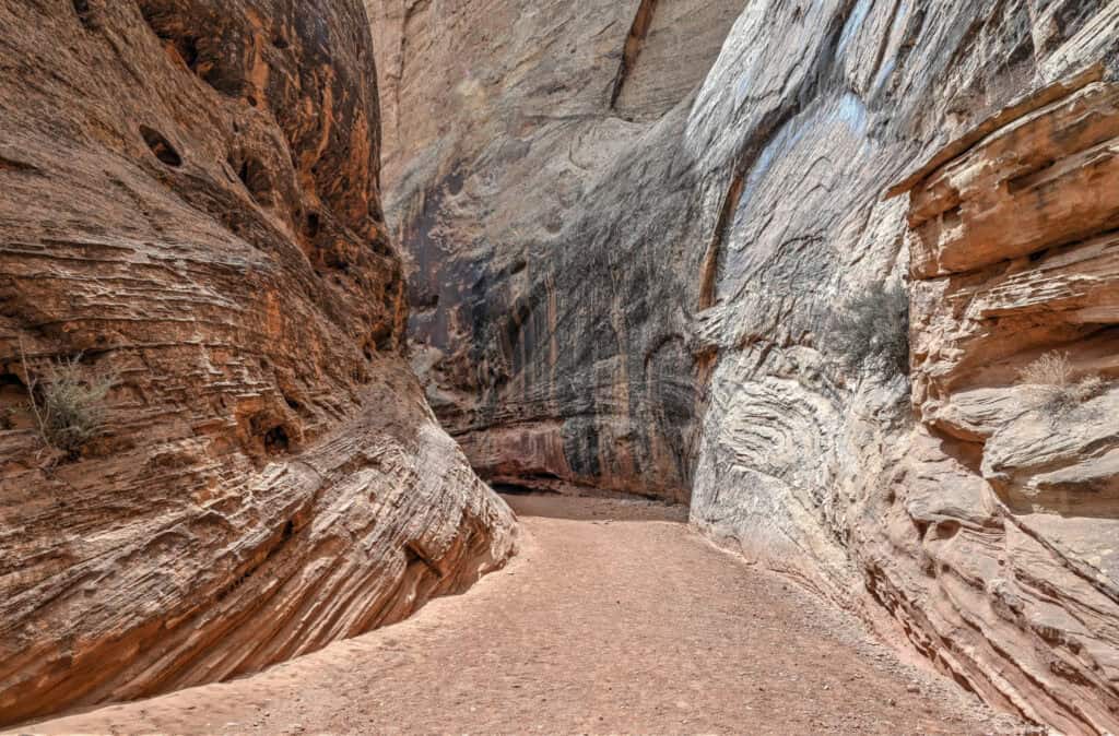
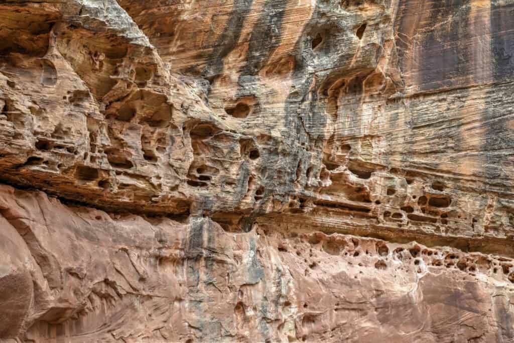
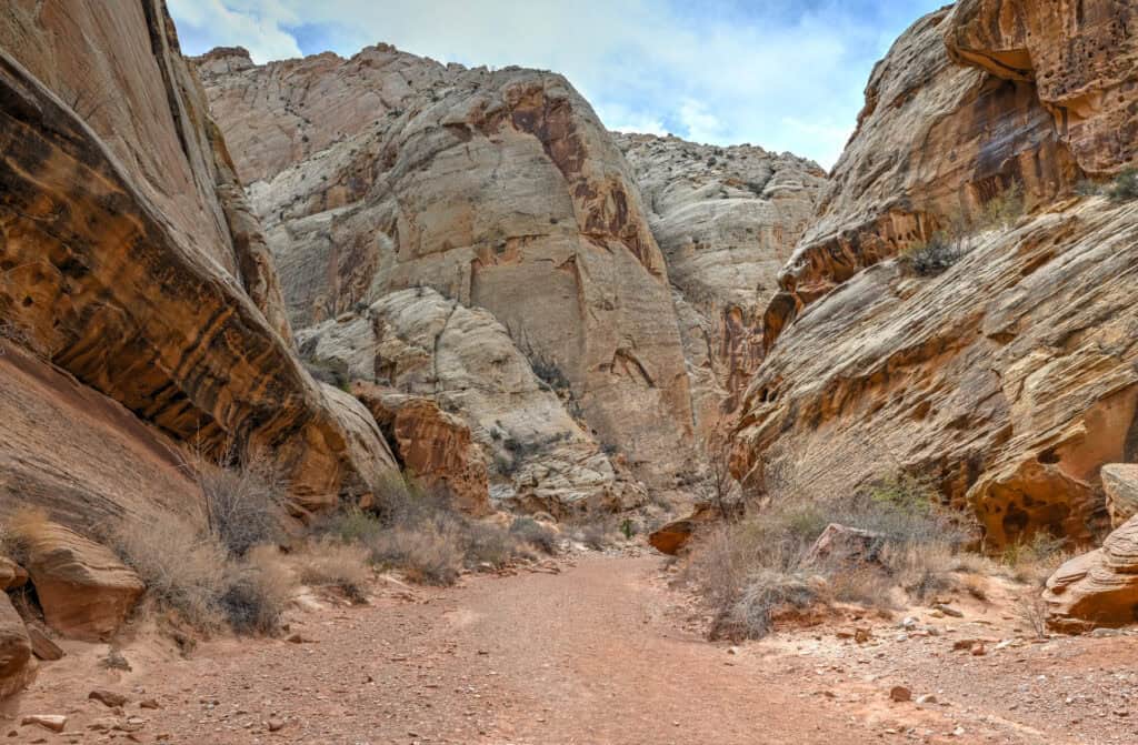
Willis Creek Slot Canyon trail – (link to Google Maps)
One of southern Utah’s most family-friendly slot canyon hikes, Willis Creek lies about 45 minutes southeast of Bryce near the town of Cannonville. The trail follows a shallow creek that winds through narrow sandstone walls that rise to 100 feet (30 m). It’s generally easy and suitable for most hikers, though water shoes are recommended, as you will often have to navigate through ankle-deep water. The out-and-back can be shortened easily; most visitors walk the first mile through the prettiest narrows.
Important: water levels can be higher in late spring and early summer, and flash floods are a serious danger during rain events. Avoid the trail during or immediately after heavy rains.
Access note: The final stretch to the trailhead involves driving several miles on unpaved Skutumpah Road, which is generally passable for most vehicles in dry conditions but can become impassable when wet. A high-clearance 4WD is highly recommended.
Kodachrome Basin State Park – (link to Google Maps)
Just 20 miles (30 minutes) from Bryce Canyon, this often-overlooked gem features towering sandstone spires called “sand pipes,” some reaching over 150 feet tall. The park offers short scenic hikes like Angel’s Palace Trail and Shakespeare Arch (both under 2 miles), which provide fantastic views of the surrounding red cliffs and desert basins. Fewer crowds, excellent photo ops, and a compact layout make Kodachrome Basin a perfect 1–2 hour stop before continuing east on Highway 12.
Near Boulder and Escalante
Scenic Overlooks & The Hogback Ridge –
Between the towns of Escalante and Boulder lies one of Utah’s most spectacular drives: The Hogback (link to Google Maps), a narrow ridge road with steep drop-offs on both sides and endless views of slickrock canyons and desert mesas. We didn’t take pictures along the ridge, but check out Google’s street view with the link above to get a glimpse of what the drive over the ridge is like.
The drive itself is a highlight of Highway 12, and you’ll find several scenic pullouts along the stretch between Bryce Canyon and Boulder, each revealing different angles of the Escalante Canyons and the Waterpocket Fold in the distance. Two of the best stops are the Boynton Overlook and Head of the Rocks Overlook (link to Google Maps), both paved and easily accessible. Boynton Overlook offers a sweeping view of the Escalante River Canyon below, while Head of the Rocks provides one of Utah’s most iconic panoramas, miles of rippling sandstone stretching to the horizon. These are must-stop spots for photos or simply to admire the landscape.


Kiva Koffeehouse – (link to Google Maps)
Built of stone and timber and perched high above the Escalante River canyon, this café is as much an architectural gem as a scenic stop. Grab a coffee and enjoy jaw-dropping views from the wraparound windows, one of the most photogenic rest stops in Utah. It’s open seasonally (spring through fall), so check hours in advance.
Lower Calf Creek Falls Trail – (link to Google Maps)
One of the crown jewels of Grand Staircase–Escalante National Monument, this 6-mile (9.6 km) round-trip trail leads to a 126-foot (38 m) waterfall cascading into a turquoise pool surrounded by sheer sandstone cliffs. The trail follows the canyon floor and features ancient Fremont petroglyphs and lush riparian vegetation along the way. Allow 2½ to 3 hours to complete the hike, longer if you plan to relax by the falls. The trailhead has limited parking and fills early during peak season.
Best Stops Between Bryce Canyon and Moab – Scenic Highway 24
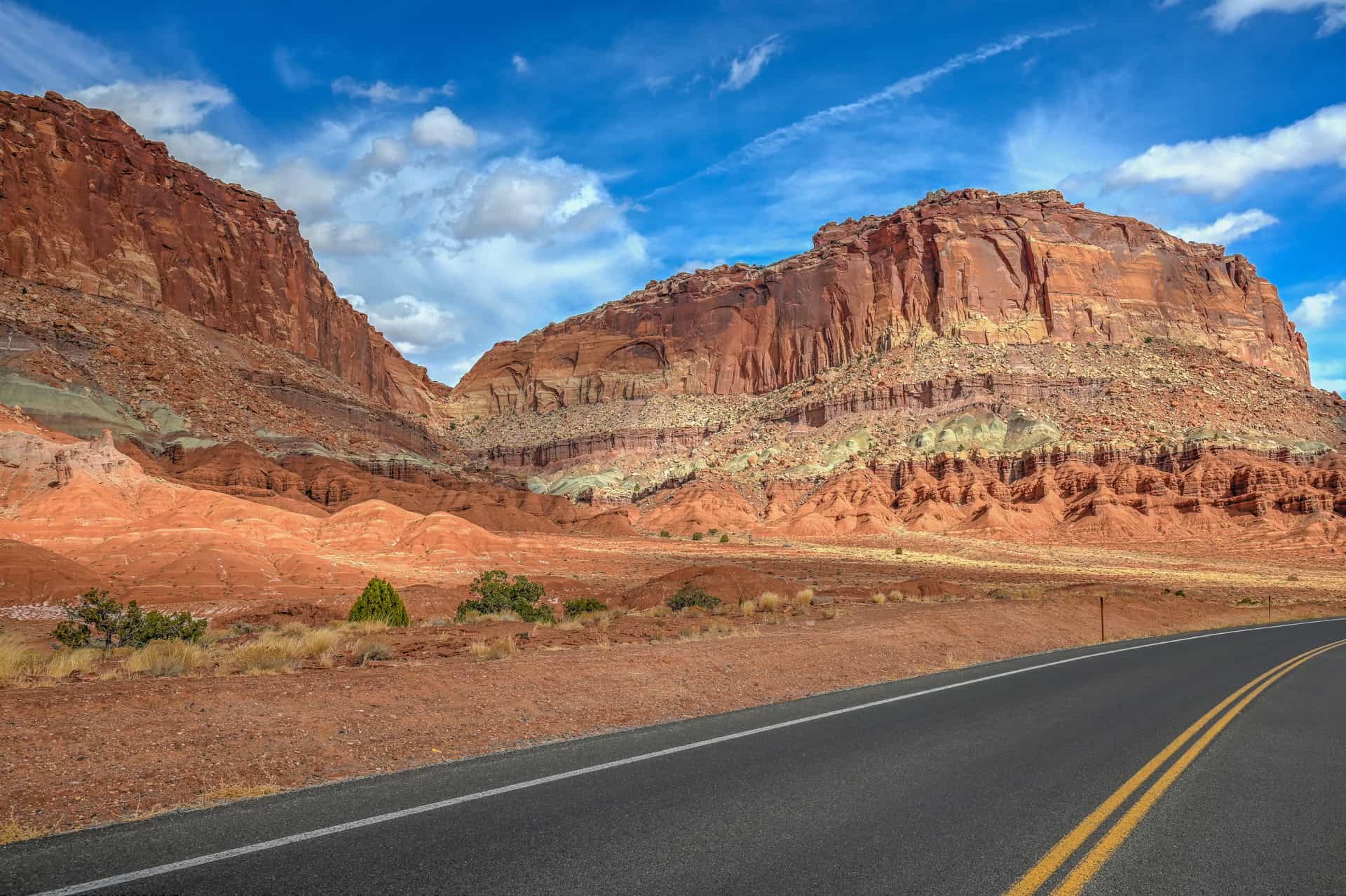
Capitol Reef National Park
Highway 24 cuts straight through the heart of Capitol Reef National Park, making it one of Utah’s most scenic drives. Even if you only have a few hours, it’s worth stopping to explore highlights like the Hickman Bridge Trail, Grand Wash Trail, the historic Fruita orchards, and Panorama Point. The stretch between Torrey and the park’s eastern boundary is packed with viewpoints, easy trails, and fascinating geology, all within a 20-minute drive. Among Utah’s “Mighty 5,” Capitol Reef is often considered the least visited, a fact many travellers see as an advantage, since trails and viewpoints feel less crowded.


For more information on this underrated National Park, check out our Capitol Reef National Park guide, where we highlight how to spend a few hours there.
Near Hanksville
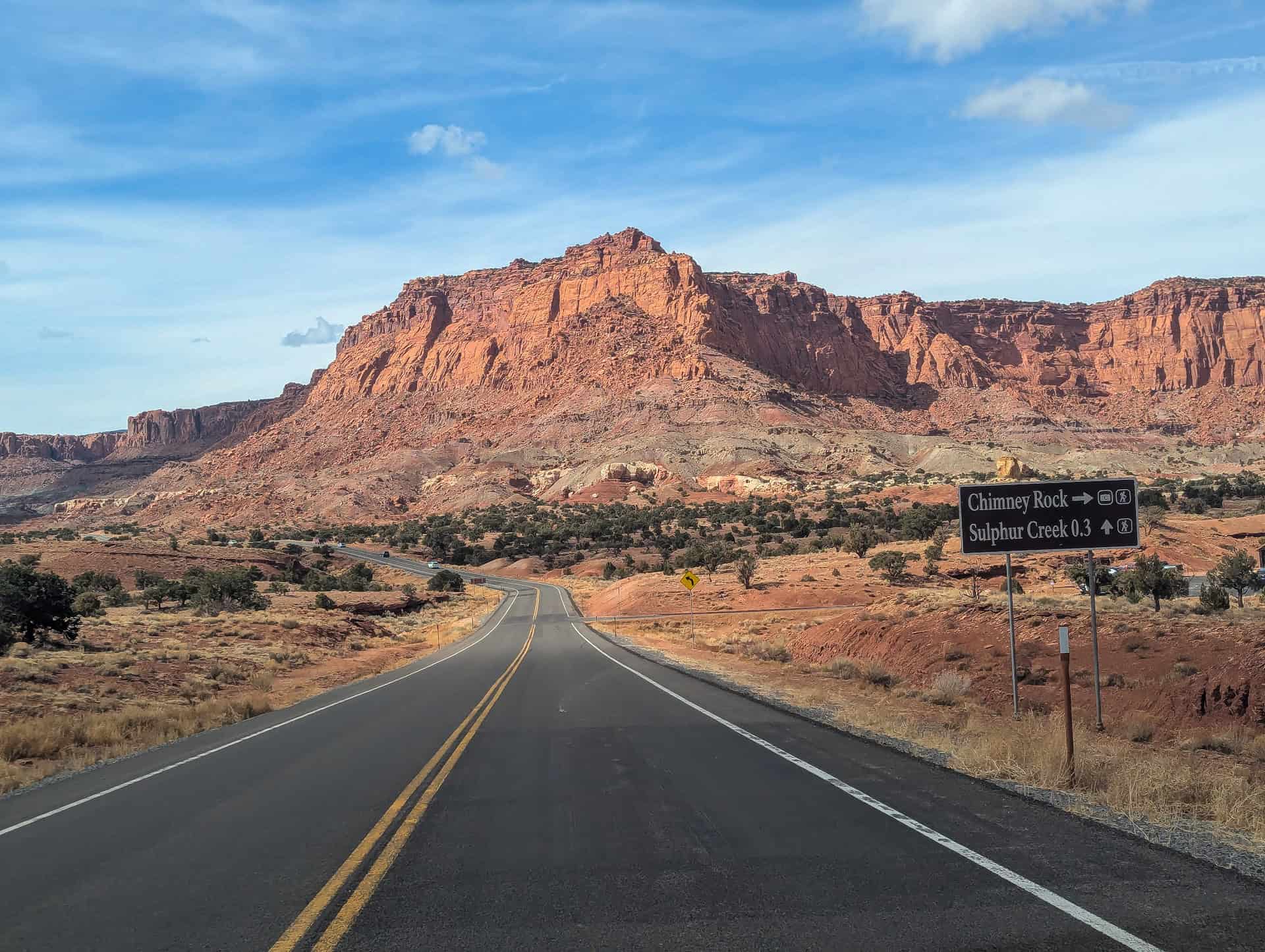
Factory Butte – (link to Google Maps)
An icon of Utah’s badlands, Factory Butte rises dramatically from the surrounding gray desert floor, its flat top visible for miles. You can reach the area via Factory Butte Road, an unpaved but usually well-graded route suitable for most vehicles in dry conditions (though high clearance is recommended). The area’s lunar-like landscape makes it a favorite among photographers and drone enthusiasts, especially at sunrise or sunset when the light softens the stark terrain.
Moon Overlook (Moonscape Overlook) – (link to Google Maps)
Continue past Factory Butte along the dirt access road to reach Moonscape Overlook, one of Utah’s most surreal viewpoints. From the edge, you’ll see miles of rippled, blue-gray clay hills that resemble the surface of another planet. The final stretch to get there involves rough, unpaved roads that are best handled with a high-clearance 4WD vehicle.
Skyline Rim – (link to Google Maps)
For even more expansive views, the Skyline Rim viewpoint lies east of Hanksville along another remote dirt road network. From this elevated ridge, you can look across the Henry Mountains and the desolate badlands surrounding Factory Butte. The route requires high clearance and desert-driving experience, but rewards the effort with unmatched solitude and panoramas few visitors ever see.
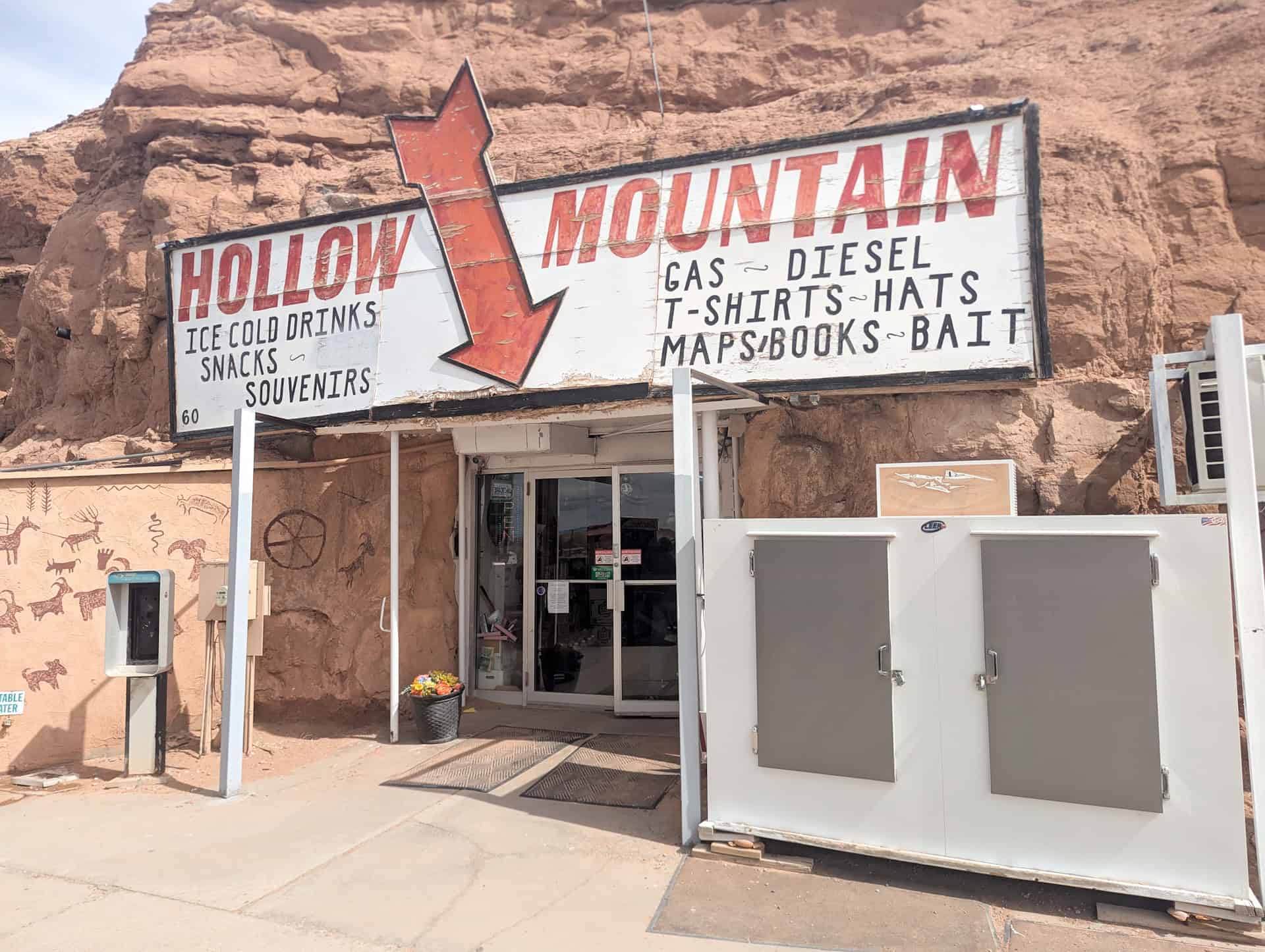
Hollow Mountain – (link to Google Maps)
Just before you reach the small town of Hanksville, you’ll find this quirky roadside stop where a convenience store has been carved directly into a sandstone cliff. It’s a fun, quick stop for photos and cold drinks, a bit of classic Utah desert Americana.
Wolverton Mill – (link to Google Maps)
Located about 5 miles southwest of Hanksville, this restored 1920s mill once processed ore from the nearby Henry Mountains mines. The historic structure and interpretive panels offer a glimpse into the area’s mining heritage.


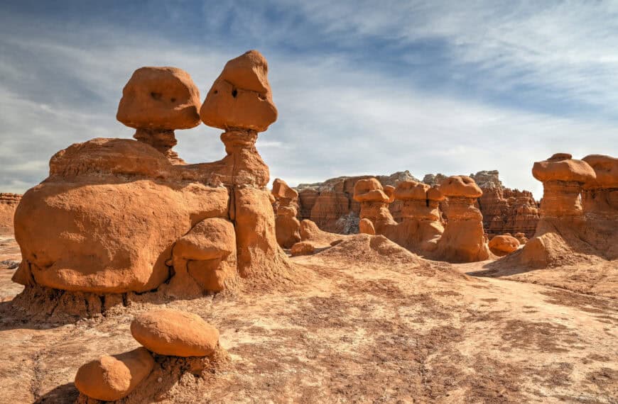
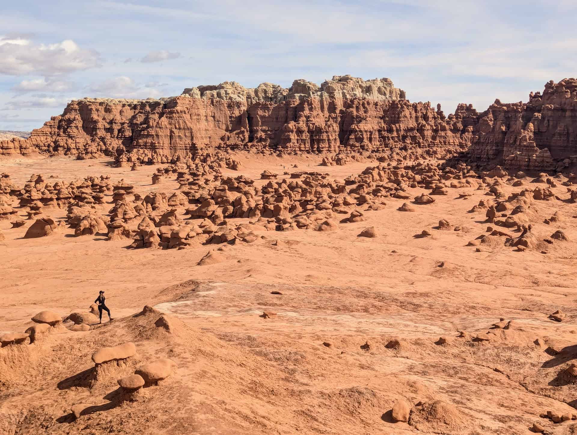
Goblin Valley State Park
Roughly 1 hour and 15 minutes northeast of Capitol Reef, Goblin Valley State Park is one of Utah’s most unique landscapes. Thousands of mushroom-shaped sandstone hoodoos, nicknamed “goblins”, fill the valley floor, forming a natural playground that invites exploration. You’re free to wander off-trail among the formations, though visitors are asked not to climb on them due to their fragility. Nearby, the Carmel Canyon Trail and Three Sisters formation offer short hikes and elevated viewpoints, while sunrise and sunset bring the goblins to life in glowing red light. Goblin Valley is compact and easy to visit in just a few hours, making it an ideal half-day stop en route to Moab or Arches National Park.


For more information on visiting this otherworldly place, be sure to check out our Goblin Valley State Park Visiting Guide, which highlights how to spend a few hours in the park.
The Roads: Scenic Highways 12 & 24
As if the many attractions along the route weren’t enough, the drive itself is part of the adventure. The landscapes visible right from the car window are as stunning as the destinations they connect. No extra words are really needed here: just a few photos will tell the story best.
Highway 12 (Scenic Byway 12)
Winding through red canyons, alpine forests, and slickrock ridges, Highway 12 is one of America’s most scenic drives: every turn reveals a new, breathtaking view.
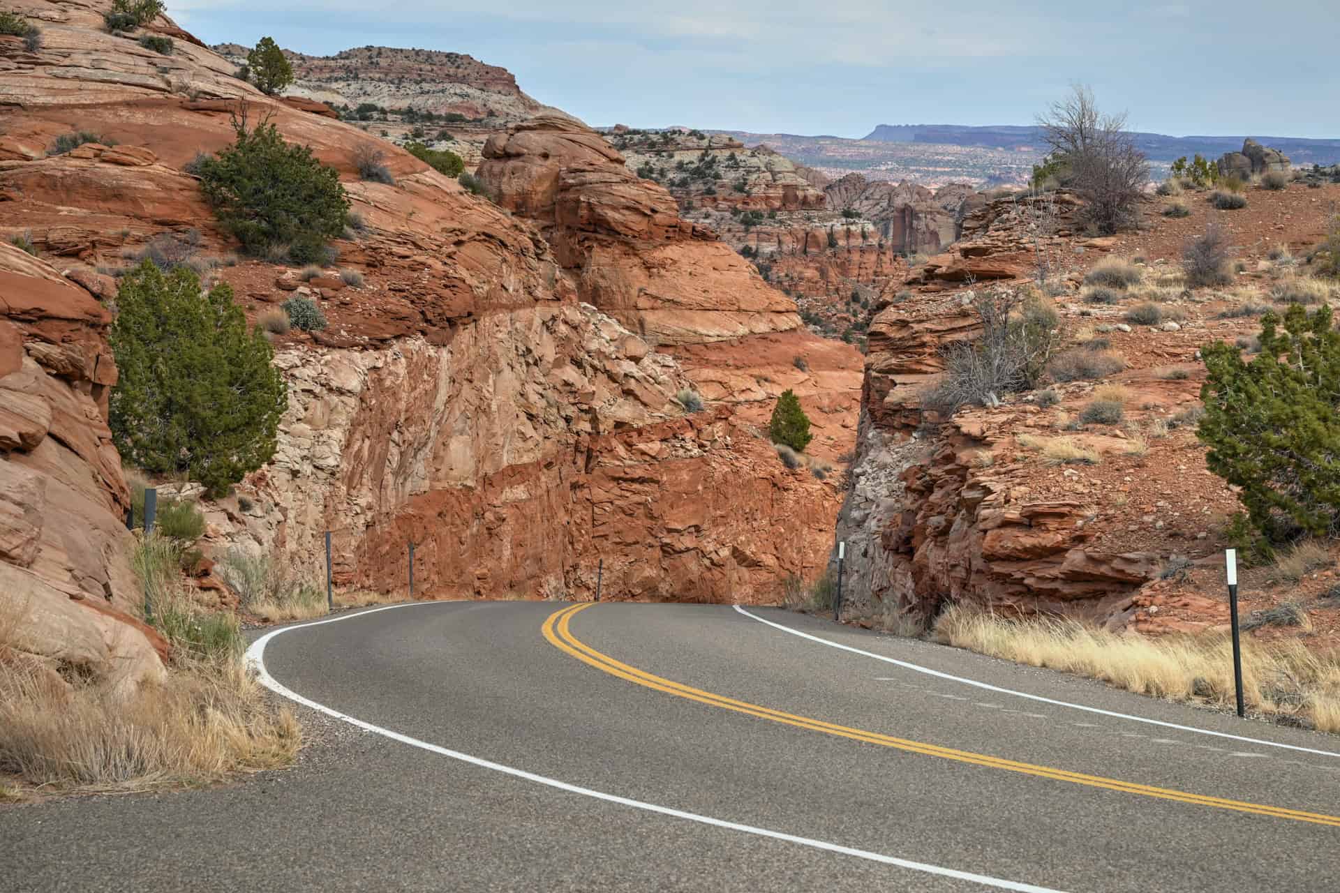

Highway 24 (Scenic Byway 24)
Cutting through Capitol Reef’s colorful cliffs and desert valleys, Highway 24 blends dramatic geology with peaceful stretches of open road: proof that sometimes, the journey itself is the highlight.


Best Hikes Between Bryce Canyon and Moab
The route from Bryce Canyon to Moab via Highways 12 and 24 passes through some of Utah’s most extraordinary hiking country. Even if you only have a day or two, several trails along the way provide incredible rewards for relatively modest effort. Below are some of the best hikes to stretch your legs, enjoy Utah’s famous red rock scenery, and experience the variety of landscapes that make this drive so unforgettable.
Mossy Cave Trail (Bryce Canyon National Park)
Bryce Canyon‘s Mossy Cave Trail offers a short 0.8-mile (1.3 km) round-trip walk that follows a small stream, passing a seasonal waterfall and leading to a shaded alcove known as Mossy Cave, which is filled with mosses in the summer and icicles in the winter. The path is easy, family-friendly, and accessible year-round.
Time required: 20–25 minutes
Willis Creek Slot Canyon (Grand Staircase–Escalante National Monument)
Located near the town of Cannonville, this trail offers a true slot canyon experience. The route follows a shallow stream through twisting sandstone narrows, where the canyon walls rise higher and tighter as you continue. It’s generally easy and suitable for most hikers, though water shoes are recommended, as you will often have to navigate through ankle-deep water. The out-and-back can be shortened easily as most visitors walk the first mile through the prettiest narrows.
Time required: 1½–2 hours round-trip
Important: water levels can be higher in late spring and early summer, and flash floods are a serious danger during rain events. Avoid the trail during or immediately after heavy rains.
Access note: The final stretch to the trailhead involves driving several miles on unpaved Skutumpah Road, which is generally passable for most vehicles in dry conditions but can become impassable when wet. A high-clearance 4WD is highly recommended.
Lower Calf Creek Falls Trail (Between Escalante and Boulder)
One of the crown jewels of southern Utah hiking, this 6-mile (9.6 km) round-trip trail leads to a 126-foot (38 m) waterfall cascading into a beautiful pool. The trail meanders through a lush canyon shaded by cottonwoods, with ancient Fremont petroglyphs visible on the canyon walls along the way. Expect soft sand underfoot, but no major elevation gain, just spectacular scenery. The trailhead has limited parking and fills early during peak season.
Time required: 2½–3 hours round-trip
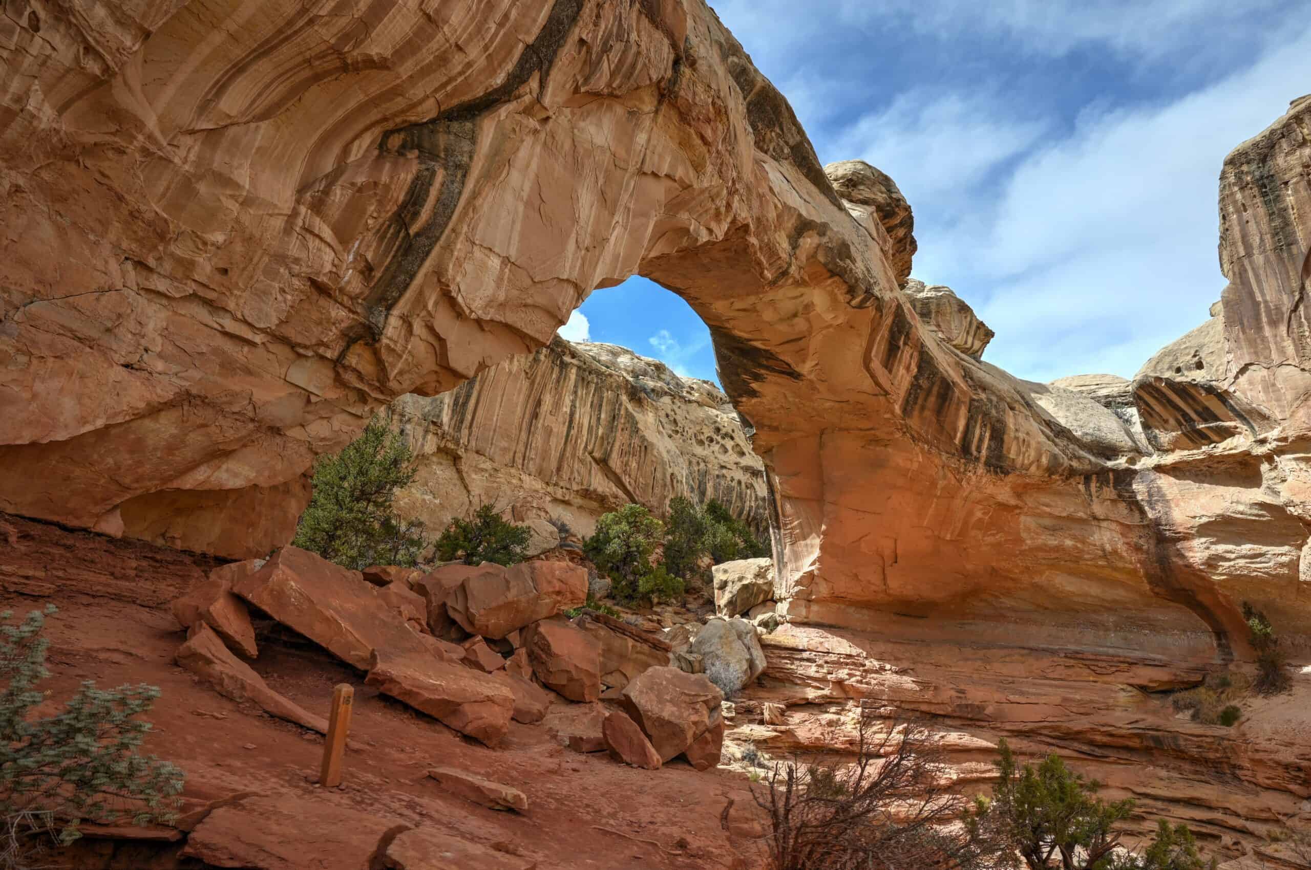
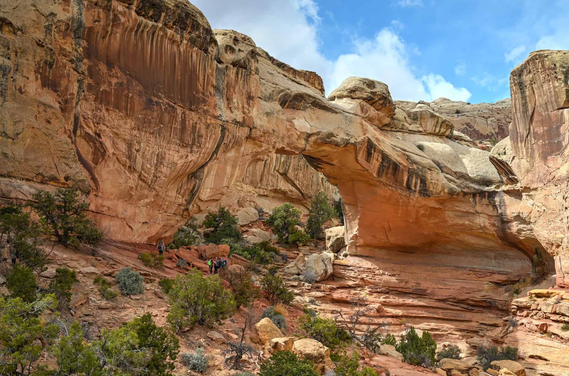
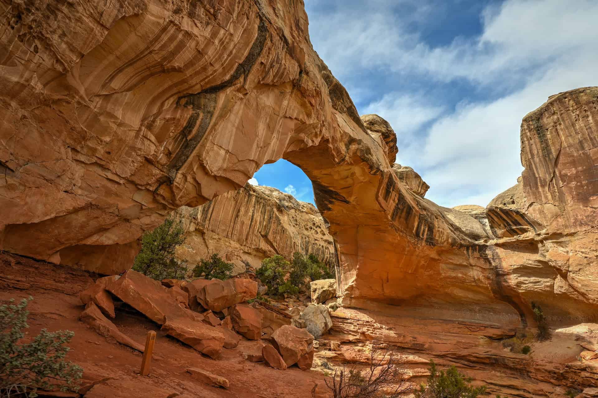
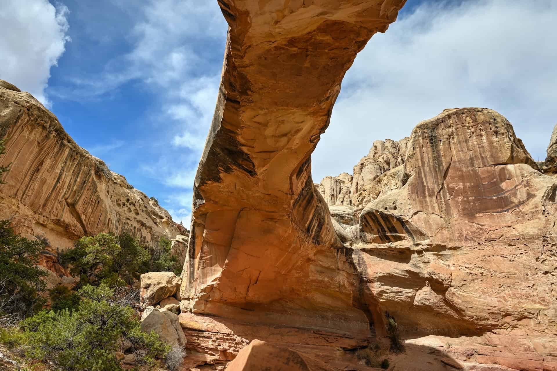
Hickman Bridge Trail (Capitol Reef National Park)
A short but rewarding trail that showcases Capitol Reef’s signature scenery. The Hickman Bridge Trail (1.8 miles / 2.9 km round-trip) ascends from the Fremont River canyon up to a massive 133-foot natural sandstone arch. The hike is moderately easy, with a steady incline at the start that levels out into a scenic wash surrounded by red rock cliffs. It’s one of the park’s most popular trails and ideal for families.
Time required: 1–1¼ hours round-trip


Grand Wash Trail (Capitol Reef National Park)
For an easy, slot-like canyon experience, head to the Grand Wash Trail. This mostly flat path follows a wide sandy wash that gradually narrows between towering Navajo sandstone walls, some rising over 500 feet high. The full out-and-back hike is 4.4 miles (7 km), but even walking the first mile gives a great taste of the canyon’s impressive scale and geology.
Time required: 1–2 hours round-trip (shorter if turning around early)


Carmel Canyon Trail (Goblin Valley State Park)
This 1.2-mile (1.9 km) loop climbs above the hoodoos for sweeping views of Goblin Valley and the Henry Mountains beyond. The trail passes the famous Three Sisters rock formation before descending into a short slot-like section carved into the canyon wall. It’s a fun, varied loop that pairs perfectly with a walk through the main valley.
Time required: 30-45 minutes round-trip


Our Suggested One-Day Itinerary: From Bryce Canyon to Moab
If you tried to see everything listed in this guide, you could easily spend several days exploring the region, as there’s that much to see along Highways 12 and 24. But for those with just a single day to make the journey, it’s still possible to experience some of southern Utah’s most spectacular scenery without needing a 4WD vehicle or venturing down remote dirt roads.
This itinerary highlights what we think are the most rewarding stops for a one-day trip from Bryce Canyon to Moab, focusing on locations that are scenic, accessible, and close to the main route. It’s exactly the route we followed ourselves, and it works just as well in reverse for those travelling from Moab to Bryce Canyon.
Morning: Scenic Viewpoints & Kiva Koffeehouse (Between Escalante and Boulder)
Start your day early from Bryce Canyon and make your way east along Highway 12. This stretch, often cited as one of America’s most beautiful drives, includes several excellent pullouts. Don’t miss Head of the Rocks and Boynton Overlooks, where you’ll get sweeping views of the Escalante canyons and endless slickrock stretching toward the horizon.

A few miles further, take a break at Kiva Koffeehouse, perched dramatically above the Escalante River canyon. The coffee and pastries are great, but the views are even better: the floor-to-ceiling windows perfectly frame the desert landscape below. It’s a great place to recharge before continuing your drive toward Capitol Reef.
Midday: Capitol Reef National Park
By late morning, you’ll reach Capitol Reef National Park, which is roughly the midpoint of your journey and one of the most scenic stops on the route. Here, two short hikes offer a fantastic introduction to the park’s landscapes:
- Hickman Bridge Trail – A 1.8-mile (2.9 km) round-trip hike to a massive natural sandstone arch. Expect modest elevation gain and sweeping views over the Fremont River canyon.

- Grand Wash Trail – A mostly flat, easy walk through a towering Navajo sandstone canyon. You don’t need to hike the full 4.4 miles; even the first mile from the Highway 24 trailhead takes you through the canyon’s narrowest, most dramatic section.
If you have extra time, stop at Panorama Point or the Fruita Barn and Gifford Homestead before heading east toward Hanksville.


Afternoon: Goblin Valley State Park
About 1 hour and 15 minutes northeast of Capitol Reef lies Goblin Valley State Park, a compact but unforgettable stop that feels like stepping onto another planet. Wander among thousands of mushroom-shaped hoodoos in the main valley, where exploration is free-form, with no set trails, and then hike the short Carmel Canyon Trail (1.5 miles / 2.4 km) for elevated views and a short slot-canyon section.


The light here is magical in late afternoon, when the goblins glow deep orange against the desert backdrop. It’s a fantastic final stop before continuing the drive toward Moab.
Optional Quick Stops: Hollow Mountain & Wolverton Mill (Near Hanksville)
If time permits, make two quick roadside stops on your way east between Capitol Reef and Goblin Valley:
- Hollow Mountain – A quirky convenience store carved directly into a sandstone cliff right in the town of Hanksville.
- Wolverton Mill – A historic 1920s ore-processing mill located about 5 miles southwest of town, offering a glimpse into Utah’s early mining days.
Total Time Estimate for This One-Day Itinerary:
With this suggested itinerary, you can expect about 4–5 hours of sightseeing and short hikes, plus roughly 5–6 hours of total driving between Bryce Canyon and Moab. It makes for a full but perfectly manageable day, and one of the most rewarding road trips in Utah.
When we followed this route ourselves, we left around 7:30 a.m. and reached our final destination near 5:30 p.m., with plenty of time for photo stops and a relaxed lunch along the way.
If you have the flexibility, consider spending a night near Capitol Reef National Park, roughly the midpoint of the journey (see further below for our suggested accommodation options). It allows for a slower pace, extra time to enjoy Fruita’s historic orchards or Goblin Valley’s surreal landscape, and a more relaxed transition between Bryce and Moab.
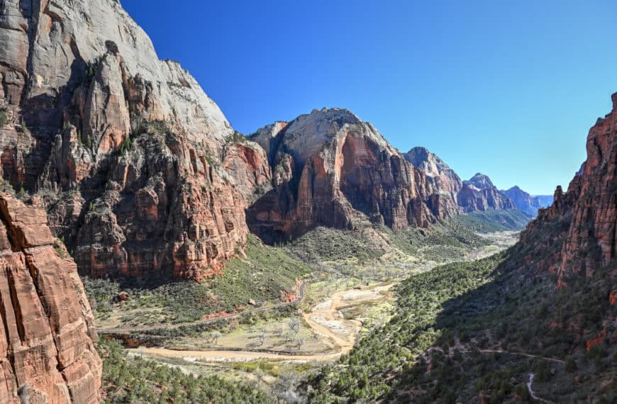
The Destinations: Bryce Canyon National Park and Moab (Arches, Canyonlands)
Bryce Canyon National Park
Bryce Canyon marks the western starting point of this scenic journey, and what a place to begin. Famous for its otherworldly amphitheatres of red and orange hoodoos, Bryce offers some of the most unique rock formations in the American Southwest. Despite the name, Bryce isn’t technically a canyon but rather a series of natural amphitheatres carved by frost, water, and time.
If you have limited time, you can see many of the park’s highlights in just a few hours. Start with the Bryce Amphitheatre area, home to iconic viewpoints like Sunrise Point, Sunset Point, and Bryce Point, all connected by short walks or a rim trail. For a closer look, descend into the hoodoos on the Navajo Loop or Queen’s Garden Trail, which showcase Bryce’s famous “Thor’s Hammer” formation up close.
At an elevation of around 8,000 to 9,000 feet (2,400–2,700 m), Bryce can be significantly cooler than other parks on this itinerary, especially in the mornings or during spring and fall, and you might want to bring a jacket even in summer.
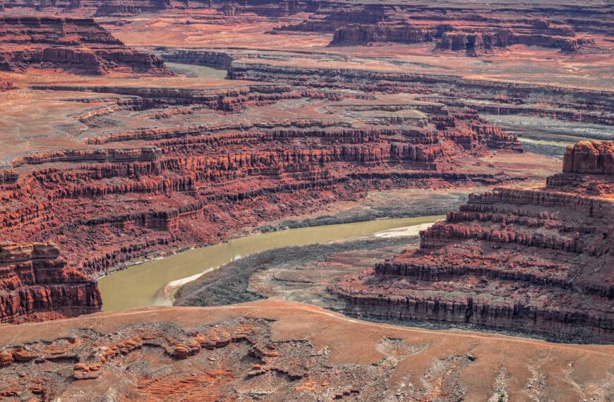
Moab (Arches & Canyonlands National Parks)
At the opposite end of this route lies Moab, the adventure capital of southeastern Utah and gateway to two of the state’s “Mighty 5” national parks: Arches and Canyonlands.
Arches National Park is just minutes from downtown Moab and boasts more than 2,000 natural stone arches, along with soaring spires and balanced rocks. The park’s scenic drive connects short, photogenic hikes like Delicate Arch, Double Arch, and The Windows, making it easy to explore even if you’re short on time.
Canyonlands National Park, by contrast, feels wilder and more expansive. The Island in the Sky District, about 40 minutes from Moab, offers jaw-dropping overlooks like Mesa Arch and Grand View Point, where vast canyons stretch to the horizon.
Moab itself is a vibrant desert town filled with cafés, gear shops, and laid-back lodges, an ideal base for exploring eastern Utah’s red-rock country. After days of hiking or driving, you can unwind with a sunset drink overlooking the Colorado River or stroll through the downtown art galleries.
Where to stay between Bryce Canyon and Moab
If you’re breaking up the drive between Bryce Canyon National Park and Moab, the area around Torrey, Caineville, and Hanksville makes the perfect midway stop. These small desert towns sit along Highways 12 and 24, right between the two destinations, and offer convenient access to Capitol Reef National Park and nearby attractions like Goblin Valley State Park.
Torrey is the most developed option, with the widest range of lodging, restaurants, and amenities, while Caineville and Hanksville offer quieter stays surrounded by classic red rock scenery, ideal for photographers, road trippers, and anyone looking to experience Utah’s open desert skies.
Torrey
Torrey is the main gateway to Capitol Reef and has the widest range of accommodations, from cozy inns to full-service resorts. It’s also where you’ll find the best selection of restaurants and shops.
Capitol Reef Resort – The area’s most upscale lodging, offering cabin, wagon, and teepee stays with stunning views of red cliffs and on-site amenities like a pool and restaurant.
Broken Spur Inn & Steakhouse – Comfortable Western-style rooms and hearty dining just a few minutes from the park entrance.
SkyRidge Inn – A charming bed and breakfast known for its panoramic vistas and peaceful atmosphere, perfect for couples or quieter stays.
Days Inn by Wyndham Torrey Capitol Reef – A practical, budget-friendly option with simple rooms and easy highway access.
Hanksville
About 45 minutes east of Fruita, Hanksville is a small desert outpost well-positioned for exploring Capitol Reef’s eastern side or nearby Goblin Valley State Park.
Whispering Sands Motel – A clean, comfortable classic roadside motel with friendly service, ideal for travellers continuing toward Moab or Lake Powell.
Caineville
Halfway between Torrey and Hanksville, this tiny settlement sits in a dramatic desert setting, surrounded by badlands and open skies.
Cathedral Valley Inn – A peaceful and simple motel popular with photographers and off-road adventurers, offering quick access to the Cathedral Valley Loop and other remote park areaslar with photographers and off-road adventurers, offering quick access to the Cathedral Valley Loop and other remote park areas.
Driving Between Bryce Canyon and Moab – Frequently Asked Questions
How long does it take to drive between Bryce Canyon and Moab?
The full drive via the scenic Highway 12 and Highway 24 route takes about 5 to 6 hours without stops. However, with viewpoints, small towns, and park visits along the way (like Capitol Reef), most travellers spend a full day or even two enjoying the journey.
Are there gas stations along Highways 12 and 24?
Gas stations are sporadic but reliable if you plan ahead. You’ll find them in Escalante, Boulder, Torrey, Hanksville, and Green River. The longest gap without services is between Hanksville and Green River (60 miles / 95 km), so always top up when possible.
What’s the highest point along the route?
The drive through Dixie National Forest near Boulder on Highway 12 reaches about 9,600 feet (2,925 m) in elevation. Temperatures there can be 10–15°F cooler than surrounding desert areas, and snow is possible in winter and early spring.
Is Highway 12 safe to drive?
Yes. Highway 12 is fully paved and maintained year-round, but it’s also narrow and winding in spots, especially on The Hogback (link to Google Maps), a ridge with steep drop-offs on both sides. Drive carefully, especially if you’re not used to mountain roads, and avoid night driving when visibility is poor.
Will I have cell service during the drive?
Expect very limited or no service between Boulder and Torrey, and throughout Capitol Reef National Park. Download offline maps before you go.
When is the best time of year to do this drive?
The most comfortable months are April through October, with spring and fall offering the best balance of mild weather and vibrant scenery.
In winter, snow and ice can affect the Boulder Mountain section of Dixie National Forest, while summer can be extremely hot in the lower-elevation desert stretches.
Can I do this drive in an RV or trailer?
Yes, RVs and trailers regularly travel Highways 12 and 24. Just be cautious on steeper grades and tight curves, and check forecasts for snow or ice in colder months.
What are the best scenic overlooks on Highway 12?
Highway 12 is packed with incredible viewpoints. Don’t miss Head of the Rocks Overlook, where you’ll get sweeping views of the Escalante Canyons and slickrock terrain. Boynton Overlook and Homestead Overlook near Boulder Mountain are also must-stops, offering dramatic perspectives of Utah’s canyon country and the Henry Mountains.
What about viewpoints along Highway 24?
As you approach Capitol Reef, Panorama Point and the Goosenecks Overlook near the west entrance offer stunning views of the Waterpocket Fold. Inside the park, you’ll find numerous pullouts and photo ops along the paved Scenic Drive Road.
Where can I stop for food or coffee along the way?
The route passes through a few small but memorable towns.
- Escalante: Try Kiva Koffeehouse, perched above the Escalante River Canyon
- Boulder: Stop at Hell’s Backbone Grill & Farm, a beloved spot known for its farm-to-table cuisine and rustic charm (open seasonally).
- Torrey: The gateway to Capitol Reef has several great options, including Capitol Burger, Café Diablo, and The Rim Rock Patio for post-hike meals with a view.
What are some good short hikes or detours along the route?
For easy and rewarding stops, try the Grand Wash Trail or the Hickman Bridge Trail inside Capitol Reef, a short 1-mile climb to a massive natural arch.
If you have extra time, wander among the hoodoos at Goblin Valley State Park, about 30 minutes off Highway 24 east of Capitol Reef.
Are there unique roadside stops worth checking out?
Yes! Hollow Mountain, a convenience store carved into solid rock in Hanksville, is a quirky must-see. Also near Hanksville, Factory Butte and Moonscape Overlook offer jaw-dropping badlands views, though you’ll need a high-clearance 4WD vehicle for the latter.
Explore More Utah Roadtrip Guides
Continue exploring Utah with these detailed guides:
Best Stops and Attractions Between Vegas and Zion
Best Stops and Attractions Between Moab and Monument Valley
Best Stops and Attractions Between Zion and Bryce Canyon
Photography Gear
If you like our photography, you might be interested in some of the gear we use to shoot our travel and hiking destinations.
Camera Body – Nikon Z 6ii Fx-series Mirrorless Body
Main Lens – NIKON 24-120mm F/4G ED VR AF-S
Zoom Lens – Sigma 745-306 150-600mm f/5-6.3
Polarizing filters – Urth Circular Polarizing (CPL)
Camera Tripod – K&F Concept 64-inch Camera Tripod
Mini-tripod – Lammcou Flexible Camera Tripod
Camera/hiking backpack – Vanguard Alta Rise 48 Backpack
Universal Travel Adapter – VYLEE Universal International Power Travel Plug
Other Travel Essentials
Travel Insurance
SafetyWing is a travel insurance company that offers comprehensive coverage for travellers. Includes Medical Insurance and Travel Insurance. Primarily geared towards long-term travellers, digital nomads, and expats.
e-Sim cards
Airalo is the world’s first and largest eSIM store with eSIM plans for 200+ countries and regions worldwide. With Airalo eSIMs, travellers can get connected the moment they land at their destination and avoid nasty data roaming charges
eSIMS are a sustainable alternative to single-use SIM cards – they are 100% digital, require less energy to produce and be re-used rather than disposed of.
Car Rentals
Discover Cars is our go-to website for car rentals. We almost always find our preferred rate there.
Transfer from Airport
Welcome Pickups is our favourite private transfer service, which you can pre-book at a fixed price. Currently available in 220 cities all over the world (mostly in Europe, but with several major cities in Asia, the Middle East and the US).
Kiwitaxi is another private transfer service – we haven’t tried it yet, but it’s currently available in a few more countries (102 as of 2024).
Hotels and Accommodations (coming soon)
Photography Prints
If you found this blog useful, you can help support our blog by purchasing low-cost digital prints. Printed physical prints are also available for purchase.


—–
Well, that wraps it up! We hope you enjoyed our Utah Road Trip Guide on the Best Stops on the Drive from Bryce Canyon to Moab and that it will prove useful for planning your trip.
—–
You might also be interested in these related pages: