The Rim Trail provides one of the easiest ways to experience Bryce Canyon’s hoodoo-filled amphitheatre, with near-continuous views from above. Instead of dropping into the canyon, the trail, as its name suggests, follows the rim, connecting several of Bryce’s best-known viewpoints and offering wide, open panoramas across the amphitheater.
While the full Rim Trail is rather long and somewhat challenging, the one-mile stretch between the North Campground and Upper Inspiration Point, which also connects to Sunrise Point and Sunset Point, packs some of the park’s best scenery into a short, manageable walk. It’s mostly flat, well-maintained, and easy to follow, making it a good option for just about anyone. You honestly won’t find such rewarding views for such little effort anywhere else in the park.
While the viewpoints themselves can feel crowded at times, walking this section of the Rim Trail lets you move away from the viewpoint clusters and enjoy the views at a quieter, more relaxed pace. It was one of our favorite places to visit in Bryce, and where we took some of our favorite pictures.
In this Bryce Canyon hiking guide, we focus specifically on the one-mile-long amphitheatre section of the Rim Trail, covering access points, parking and shuttle options, trail conditions, and what to expect along the way. Whether you’re looking for a relaxed scenic walk or a flexible alternative to Bryce’s steeper trails, this guide will help you decide if the Rim Trail is the right fit for your visit.
Rim Trail – At a Glance
Continuous amphitheater views from above – The Rim Trail follows the edge of Bryce Canyon’s main amphitheater, delivering uninterrupted views across dense hoodoo formations without descending below the rim.
Minimal elevation change, maximum payoff – Unlike Bryce’s below-the-rim hikes, this section of the Rim Trail is largely flat and well-maintained. You get sweeping vistas without steep climbs, making it accessible to almost everyone.
Highly flexible and easy to customize – The stretch between the North Campground and Upper Inspiration Point passes multiple viewpoints and access points. You can walk a short segment, link viewpoints together, or turn back at any point without committing to a fixed route.
Ideal in all seasons – Because the trail stays along the rim, this one-mile section is one of the best options in winter or icy conditions, when descending trails into the amphitheater may be unsafe or closed.
Trail Difficulty (one-mile-long amphitheatre section): Very Easy
Typical Hike Duration: 45 – 60 minutes


Disclosure: This page (Rim Trail – Bryce Canyon National Park Hiking Guide) may contain product affiliate links. At no additional cost to you, we may receive a commission for purchases made through these links. More details can be found on our disclosure and policies page.
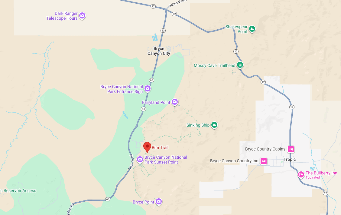
Rim Trail: Location and Map
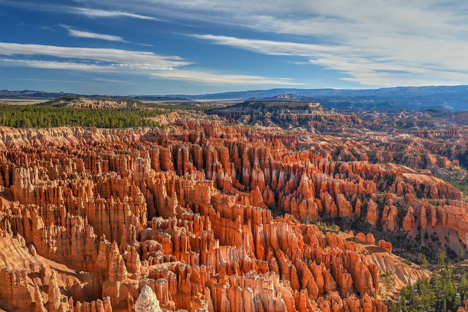
The Rim Trail follows the edge of Bryce Canyon’s main amphitheater, with its main section running along the rim between the North Campground and Upper Inspiration Point. This section of the trail links many of the park’s most famous viewpoints, including Sunrise, Sunset, and Inspiration Points, placing you directly above the densest concentration of hoodoos in the park.
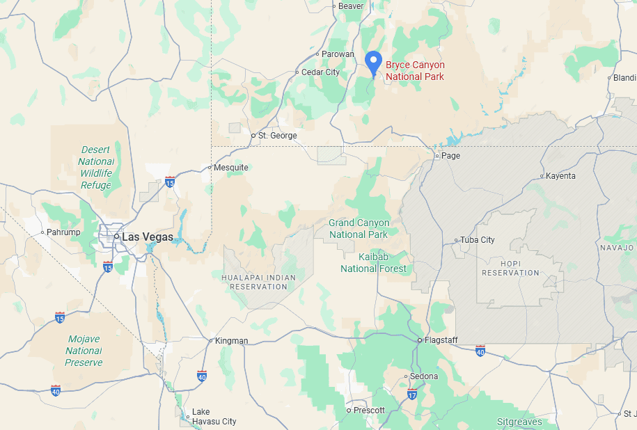
How to Get to Bryce Canyon National Park
Bryce Canyon National Park is best reached by car, as there is no public transportation that provides direct access to the park.
Driving times to Bryce Canyon National Park
- Zion National Park: 135 km / 85 mi – about 2 hours
- St. George, UT: 240 km / 150 mi – about 3 hours
- Page, AZ: 240 km / 150 mi – about 3 hours
- Las Vegas, NV: 420 km / 260 mi – about 4.5 hours
- Salt Lake City, UT: 430 km / 270 mi – about 4.5 hours
These times assume clear weather and normal traffic conditions.
If you need to book a rental vehicle for your hiking excursion, we highly recommend using Discover Cars to get the best rates on your rental in Utah, Nevada and Arizona.
We also highly recommend Airalo (eSIM card) for your connectivity needs when travelling abroad. Airalo is the world’s first and largest eSIM store with eSIM plans for 200+ countries and regions worldwide.
About Bryce Canyon National Park
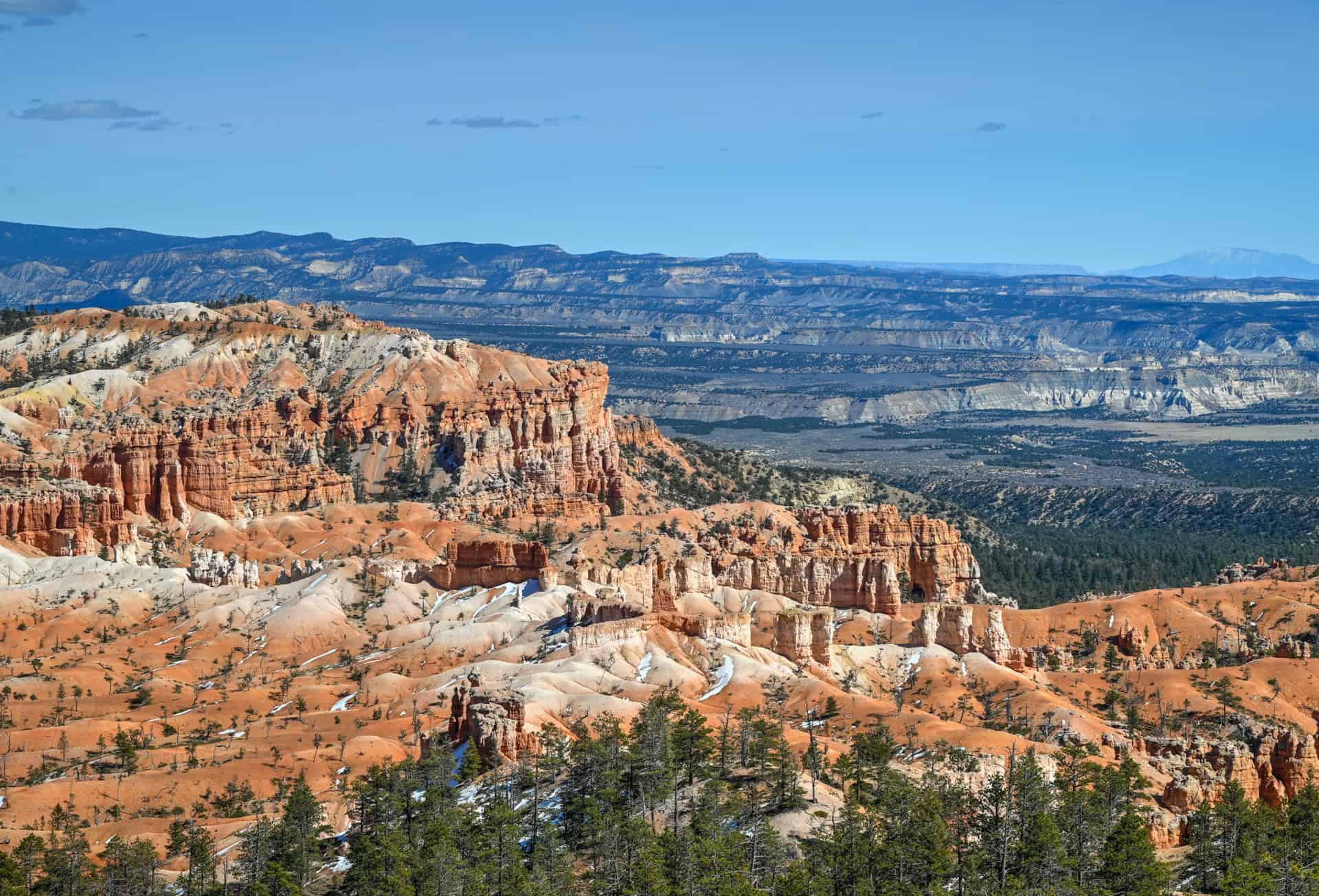
Utah’s Hoodoo Wonderland: Bryce Canyon National Park sits along the Paunsaugunt Plateau in southern Utah, where thousands of spire-shaped rock formations, known as hoodoos, rise from a series of natural amphitheaters. Rather than a single canyon, Bryce is defined by expansive bowl-shaped landscapes filled with tightly packed fins, pinnacles, and towers, creating one of the most surreal and instantly recognizable scenes in the American Southwest.
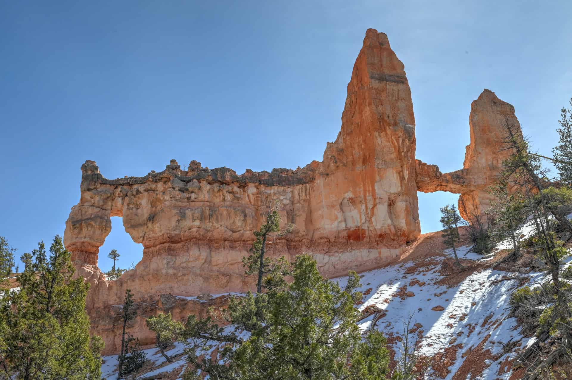
A Landscape Sculpted by Frost and Erosion: Unlike Zion’s river-carved canyons, Bryce’s formations are shaped primarily by freeze–thaw cycles and erosion. Rainwater seeps into cracks in the limestone and sandstone, freezes overnight, and expands, slowly prying the rock apart over thousands of years. This process has created Bryce’s delicate hoodoos, arches, and windows, with vivid red, orange, and pink hues that glow dramatically at sunrise and sunset.
Built for Viewpoints and Immersive Hikes: Bryce Canyon is uniquely suited to both casual sightseeing and more immersive hiking. A paved scenic drive connects a string of overlooks along the canyon rim, allowing visitors to experience breathtaking views with minimal effort. Below the rim, trails like the Navajo Loop, Queen’s Garden, and Tower Bridge descend directly into the hoodoos, offering a rare chance to walk among the formations rather than simply admire them from above.
Big Scenery in a Compact Park: Despite its relatively small size, Bryce Canyon delivers an outsized visual impact. Elevations range from about 8,000 to over 9,000 feet, providing cooler temperatures, expansive views, and some of the darkest night skies in the region. The park’s compact layout makes it easy to combine scenic overlooks, short hikes, and longer trail combinations in a single visit.
High Elevation, High Reward: Bryce’s accessibility via Highway 63 and its well-maintained infrastructure make it easy to visit, but the park’s elevation and popularity mean conditions can change quickly. Snow can linger into spring, summer thunderstorms are common, and trails can feel more strenuous due to thinner air. That said, Bryce remains one of the most rewarding parks to explore at a relaxed pace, with unforgettable views around nearly every corner.
Rim Trail – Trailhead, Parking & Fees
Trailhead Location
The amphitheater section of the Rim Trail can be accessed from multiple points along the rim, most commonly near Sunrise Point, Sunset Point, and Inspiration Point, each serviced by its own parking lot. This flexibility allows you to start and end your walk at different viewpoints rather than committing to a single out-and-back route.
Reaching the Trailhead via Bryce Canyon’s Shuttle System
During shuttle season (typically April through mid-October), Bryce Canyon National Park operates a free shuttle that serves the most popular viewpoints and trailheads along the rim. Using the shuttle is not mandatory, but it is often the most predictable way to get around the park during busy periods, especially midday when parking lots can fill up.
Visitors are still allowed to drive their own vehicles along the park road and park at designated lots, provided space is available. For those planning to use the shuttle, the National Park Service recommends parking at the additional parking lot across from the Visitor Center and boarding from there.
Trailhead Parking
Parking is available at several rim viewpoints that connect directly to the Rim Trail, including Fairyland Point, Sunrise Point, Sunset Point, and Inspiration Point. These paved lots are well distributed but can fill quickly during peak hours, particularly between late morning and mid-afternoon. Arriving early or using the shuttle makes access significantly easier.
Facilities
Toilets are available near the North campground general store, a 5-minute walk from Sunrise Point, and by the Sunset Point parking lot.
Trail Opening Hours
The Rim Trail is accessible year-round, 24 hours a day, weather permitting. Some sections of the trail may be snow-covered or icy in winter, but the trail itself is not subject to seasonal closures.
Entrance Fees for Bryce Canyon National Park
Anyone visiting Bryce Canyon National Park, whether to hike, take a scenic drive, or simply enjoy the views, must pay the applicable entrance fee to the National Park Service.
Entrance Fees (per vehicle, valid 7 days)
Private vehicle: $35
Motorcycle: $30
Individual (on foot, bicycle, etc.): $20
Annual Pass Options
Bryce Canyon Annual Pass: $70 – unlimited entry for one year from the month of purchase.
America the Beautiful Pass: $80 – valid for one year at all U.S. National Parks and more than 2,000 federal recreation sites nationwide. This is the best value if you plan to visit multiple national parks within a year.
Passes can be purchased at the park entrance station, at the Visitor Center, or online through the USGS website or via the REI store.
—> Most visitors exploring Utah’s “Mighty 5” parks (Arches, Bryce Canyon, Canyonlands, Capitol Reef, and Zion) should strongly consider the America the Beautiful Pass: it saves money and avoids the hassle of buying separate entry fees at each park.
Rim Trail Stats, Difficulty, and Map
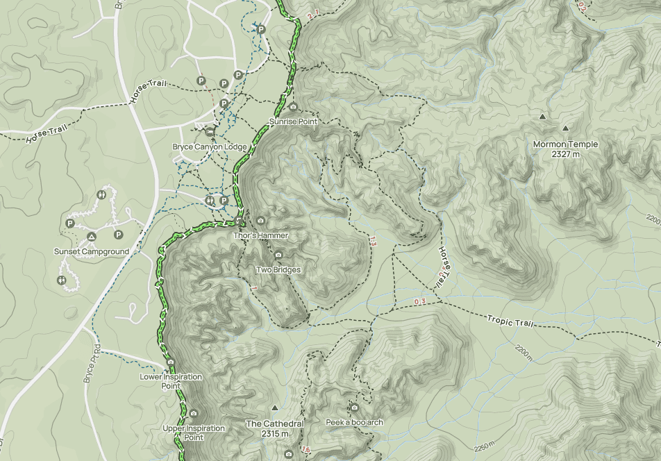
While the full length of the Rim trail runs for 5.6 miles (9 km), here we’ll focus on the one-mile section that roughly runs between the North Campground (northern trail section point) and Lower Inspiration Point (southern trail section point).
Distance: 2 miles (3.2 km)
Route Type: Out & Back
Elevation gain: 200 ft / 60 m (cumulative elevation gain)
Duration: Most people complete this section of the trail in 45 – 60 minutes
Trail difficulty level assessment:
Very Easy | Easy | Moderate | Moderately Challenging | Challenging
In our view, the central one-mile segment of the Rim trail rates as Very Easy, as it is, for the most part, very flat. The elevation gain primarily comes from minor repeated ups and downs, and the short climb between the lower and upper inspiration points.
Map of the full-length Rim Trail
Below is a zoomed-in version of the one-mile central stretch of the Rim Trail, which connects Lower and Upper Inspiration Points, Sunrise Point, and Sunset Point.
Not an AllTrails member yet? We highly recommend signing up for either their free or paid membership plans. The free plan allows you to find new trails and plan routes but it can only be used while hiking if you have access to mobile data. The paid membership plan (AllTrails+) allows you to download trail maps for offline use and provides live progress updates and off-route notifications.
If you are still uncertain – you should know that the All Trails mobile application was voted the 2023 iPhone App of the Year by Apple.
We find that AllTrails is a great tool to have when hiking, particularly for assisting with navigation when the trail is hard to locate and to help monitor your progress along the trail, which helps estimate how much time you’ll need to complete the trail.
Rim Trail – Trail Description and What to Expect
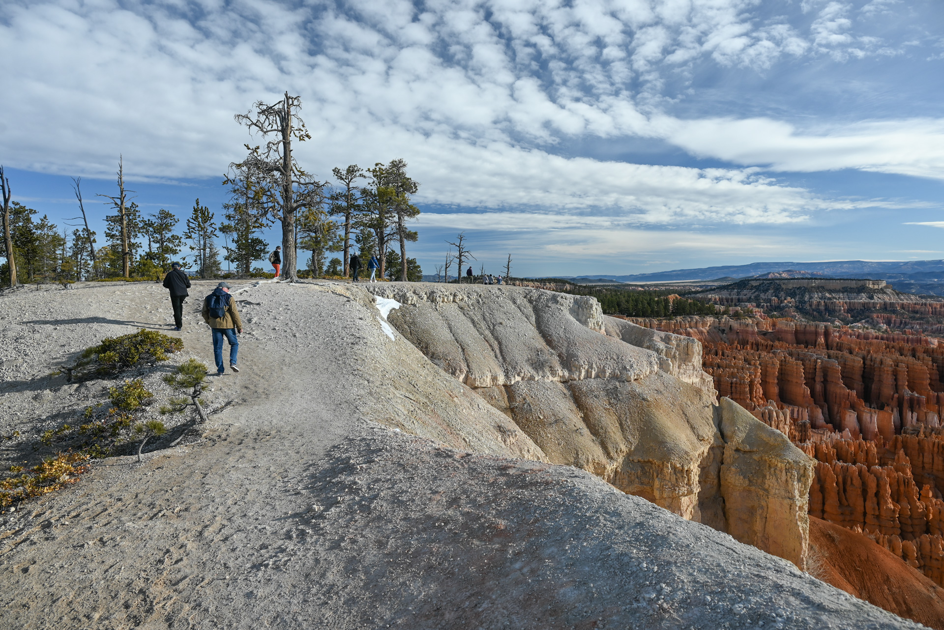
Main Amphitheater Section – There’s no single official starting point for this section of the Rim Trail, as it’s accessible from several rim viewpoints, including Sunrise Point, Sunset Point, and Inspiration Point. That flexibility is part of what makes the trail so approachable: you can walk as much or as little as you like, starting and finishing at different viewpoints.
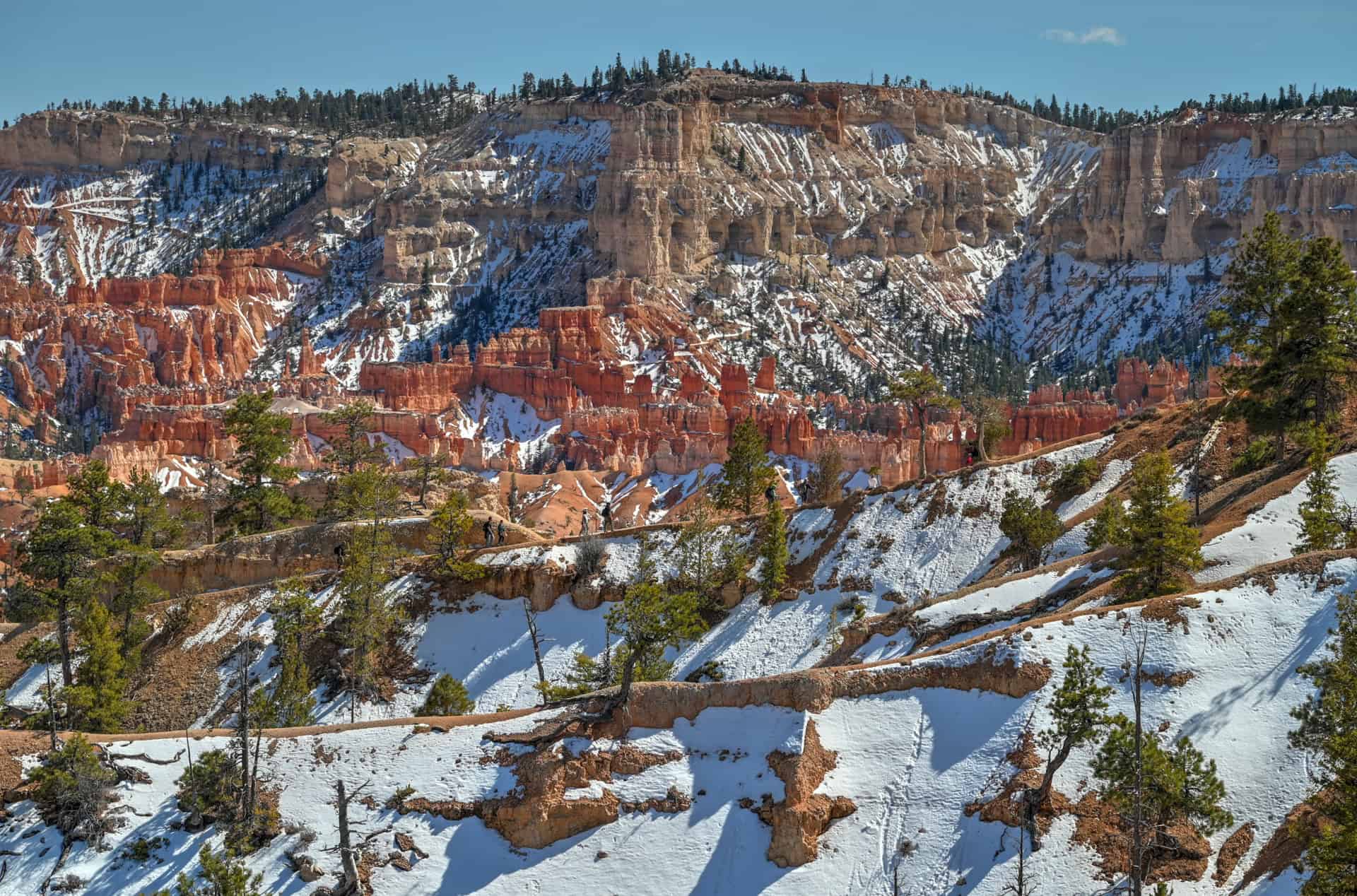
If you want to get the most physically demanding section out of the way first, a good option is to start at Lower Inspiration Point, which sits right next to the parking area. From here, head south and uphill toward Upper Inspiration Point, passing Middle Inspiration Point along the way. This short stretch, roughly a quarter mile (about 500 meters), includes the most noticeable climb along this section of the Rim Trail, but it’s brief and well-maintained.


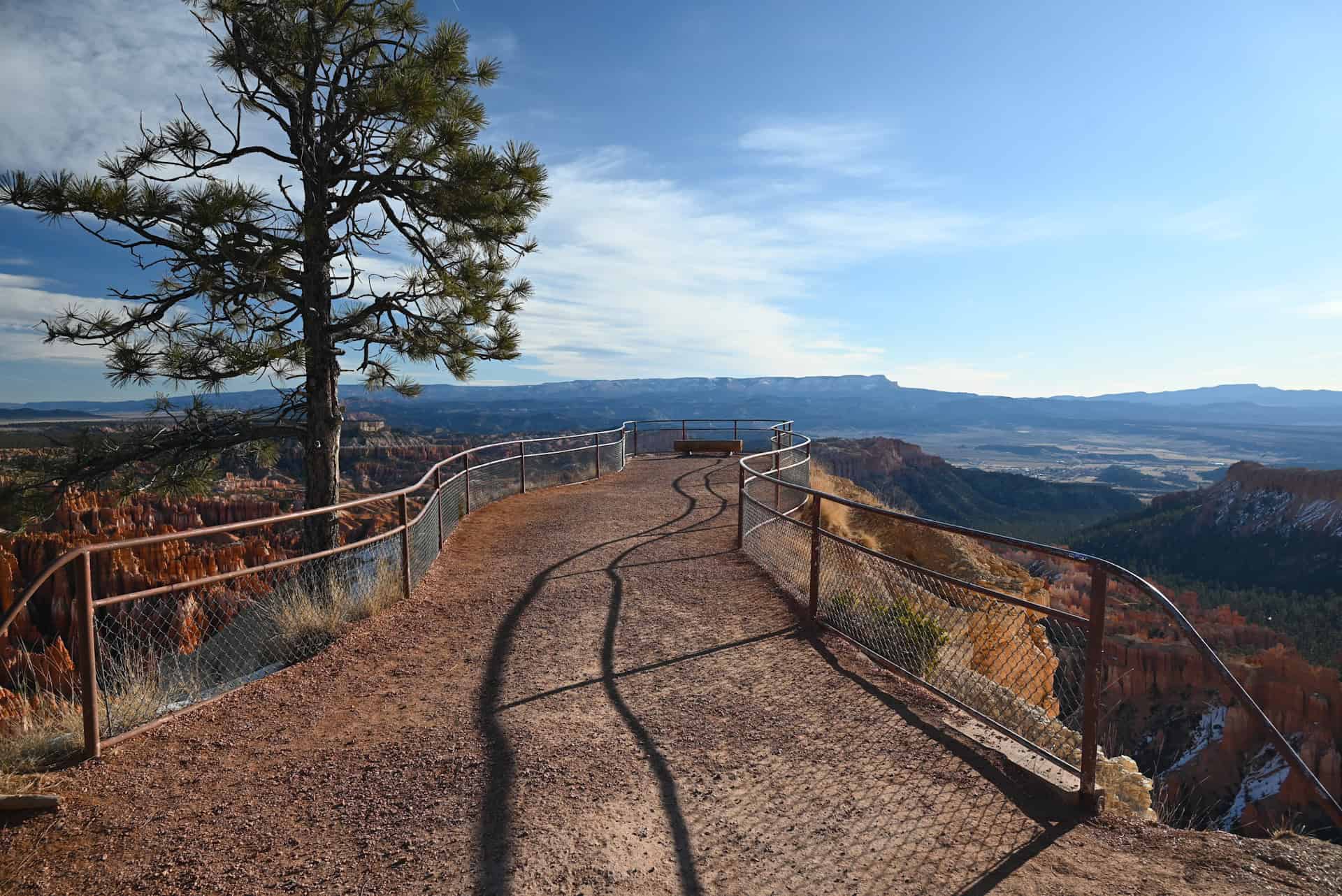
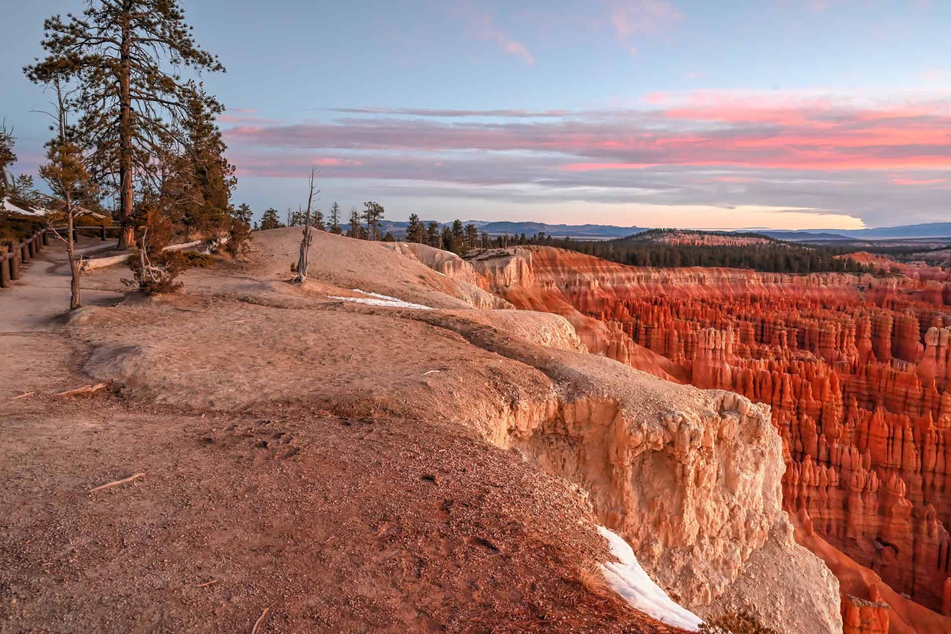
While you get a great vantage point of Bryce’s Amphitheatre from pretty everywhere along the Rim Trail, you’ll be at your most elevated point at Upper Inspiration Point. The views here are hard to beat, and it’s our favorite place for sunrise photography in Bryce.


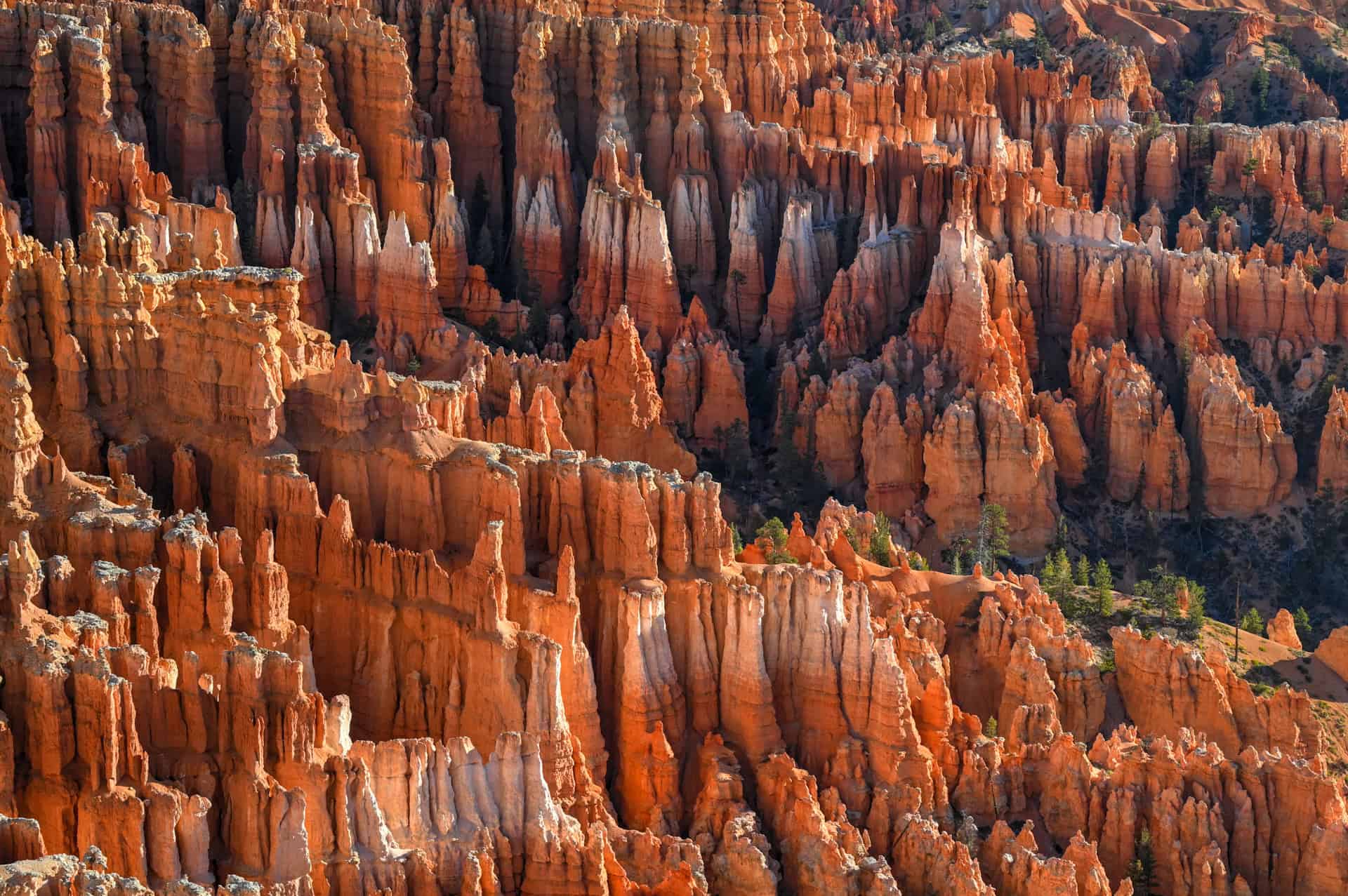
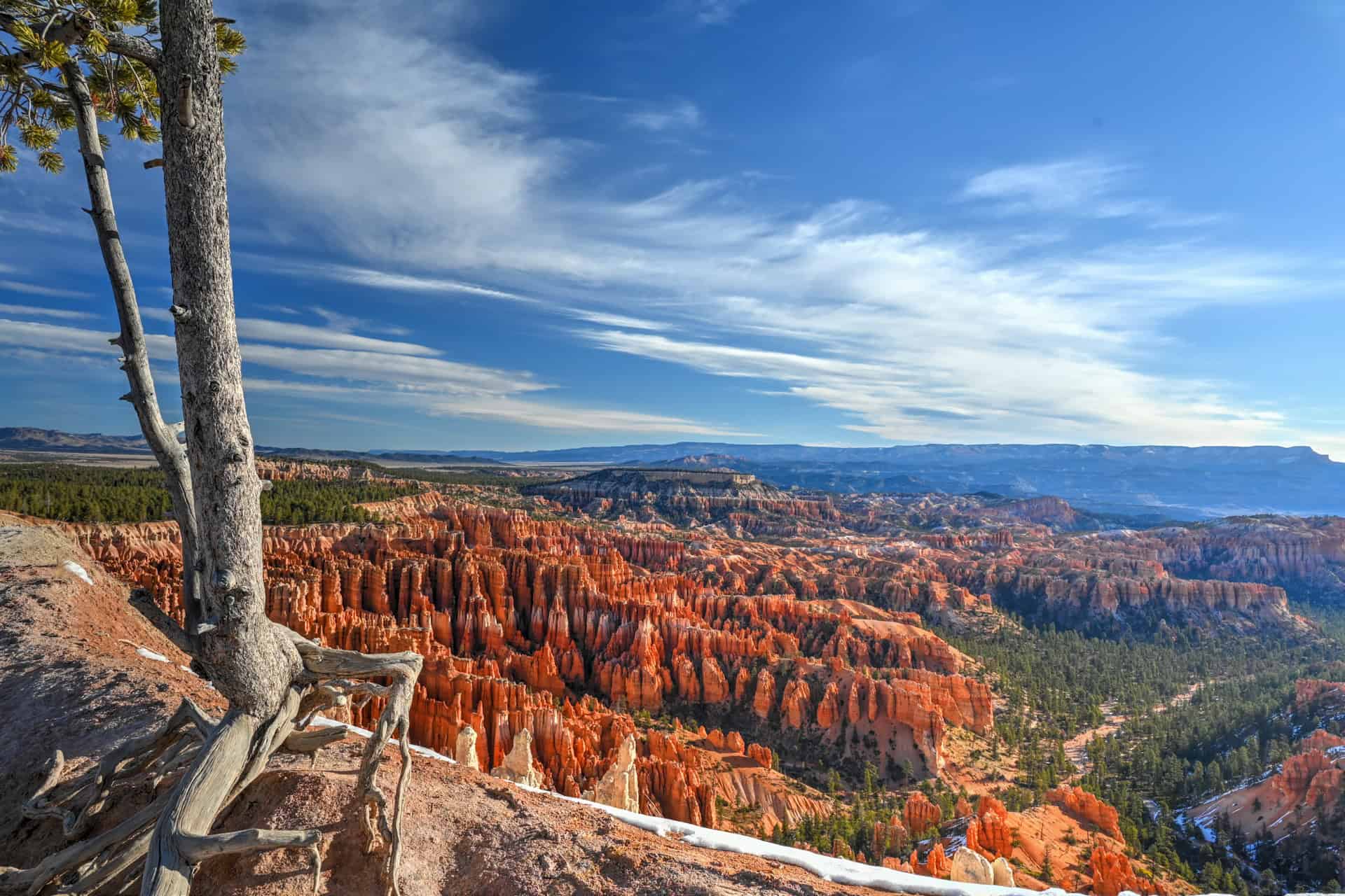
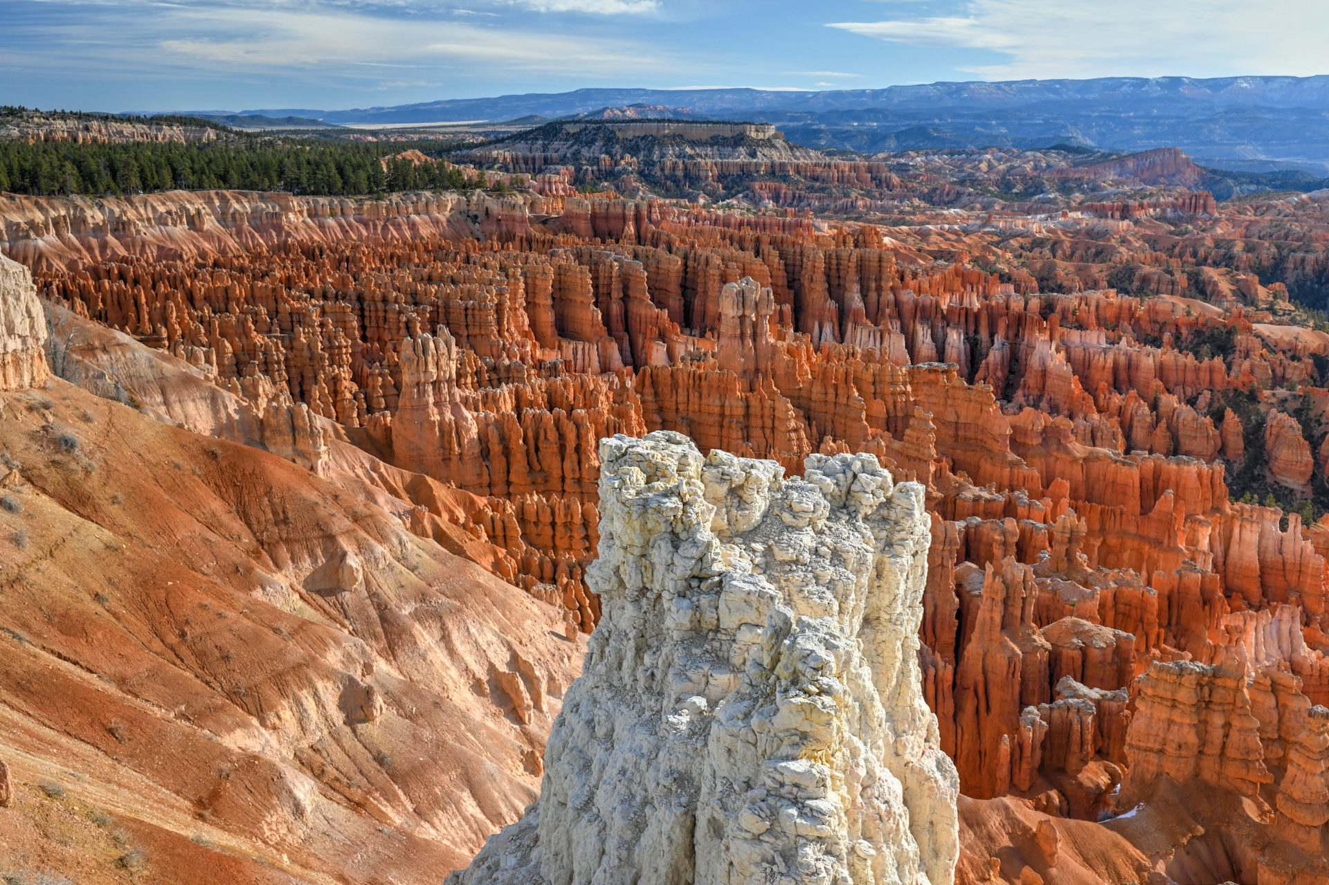
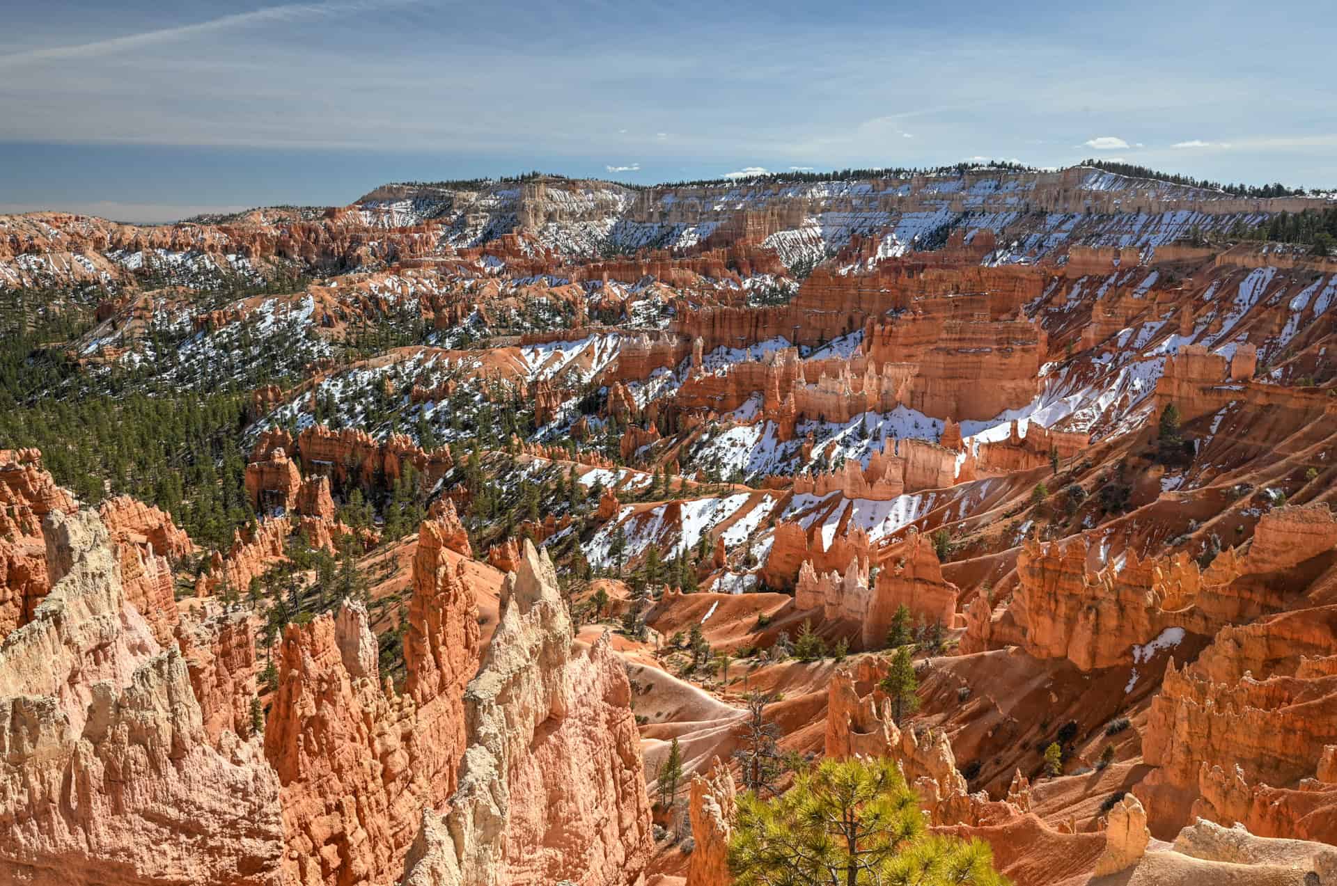
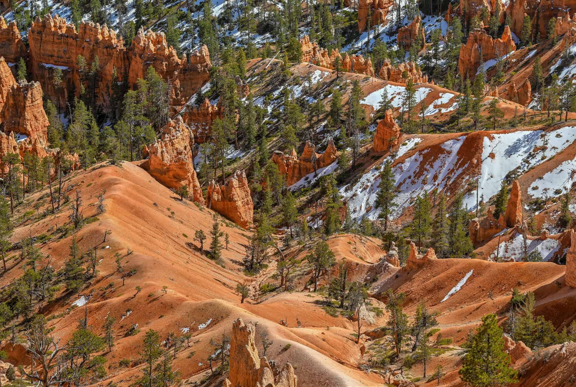
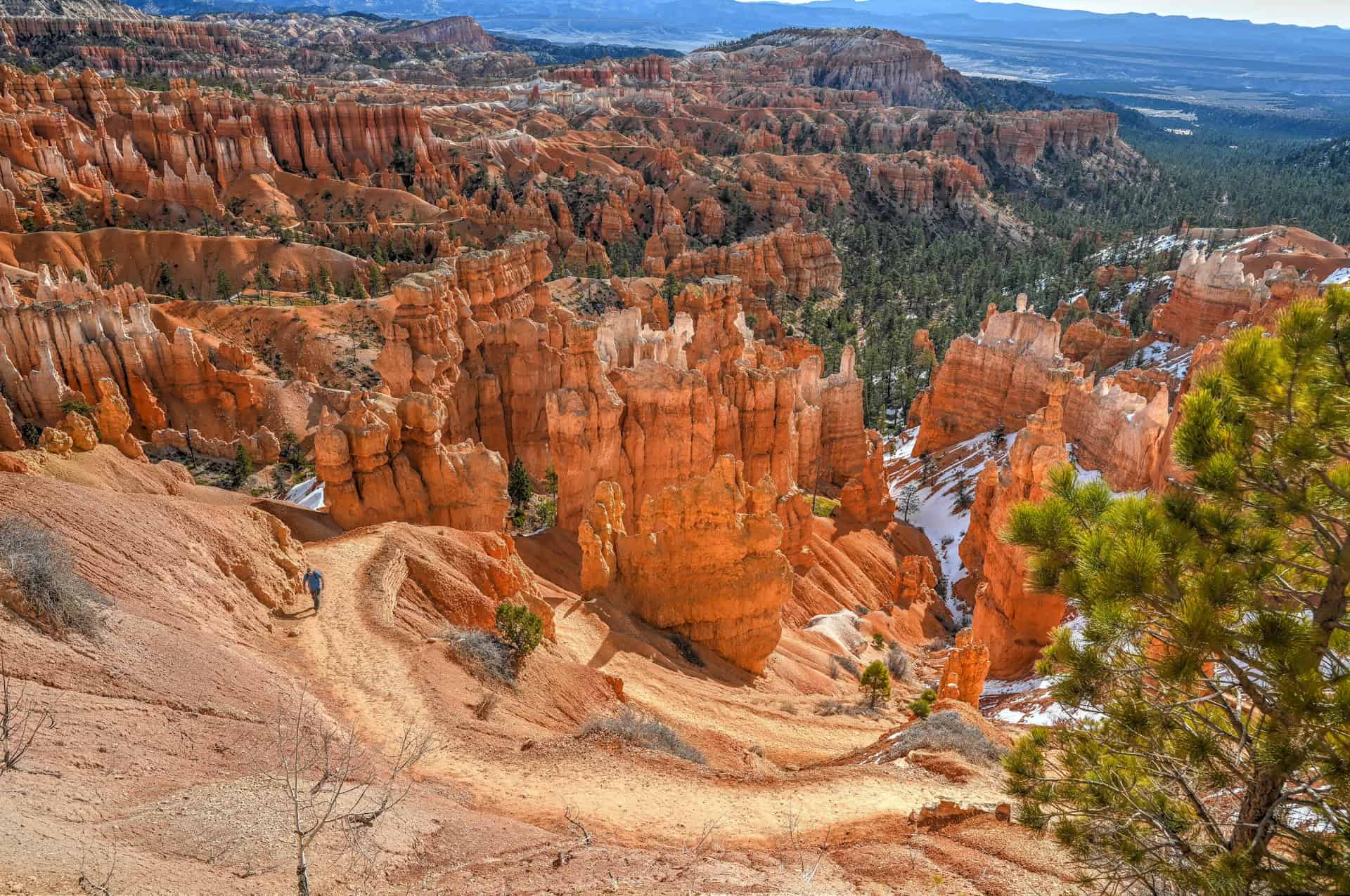
From Upper Inspiration Point, retrace your steps back past Lower Inspiration Point and continue north toward Sunset Point, about a mile away. This is the longest continuous stretch of trail without an “official” named viewpoint, but the scenery never really lets up. Hoodoos rise in dense clusters below the rim, their shapes and colors constantly shifting as the trail curves along the amphitheater edge. These formations were sculpted over time by freeze–thaw cycles and erosion, slowly carving the limestone into the spires, fins, and pinnacles that define Bryce Canyon today.


Eventually, you’ll reach Sunset Point, one of Bryce Canyon’s busiest and most popular overlooks. Its popularity is due in part to its central location and the fact that it serves as the starting point for several trails that descend into the amphitheater, including the Navajo Loop. It’s a natural place to pause, take in the view, and decide how much farther you want to go.
Continuing north for another half mile brings you to Sunrise Point, another major viewpoint with sweeping views across the amphitheater. The route to get there is the easiest to date, as this section of the trail is paved. Honestly, the scenery viewed from the trail is equally beautiful to what you would get from either viewpoint, so you should feel free to skip if they are too busy — the main difference is that guardrails are present at the viewpoint, allowing you to safely get closer to the edge.


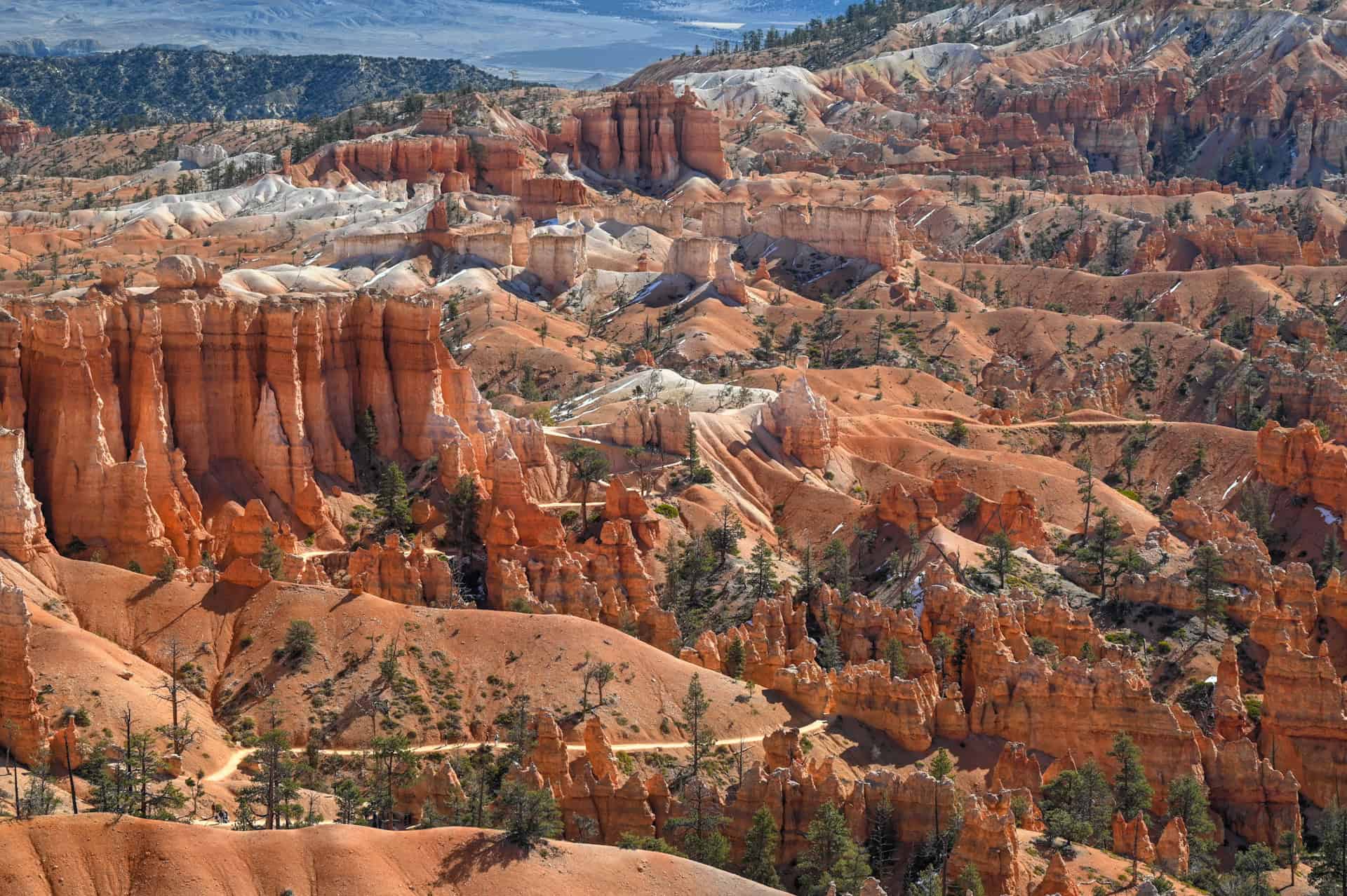
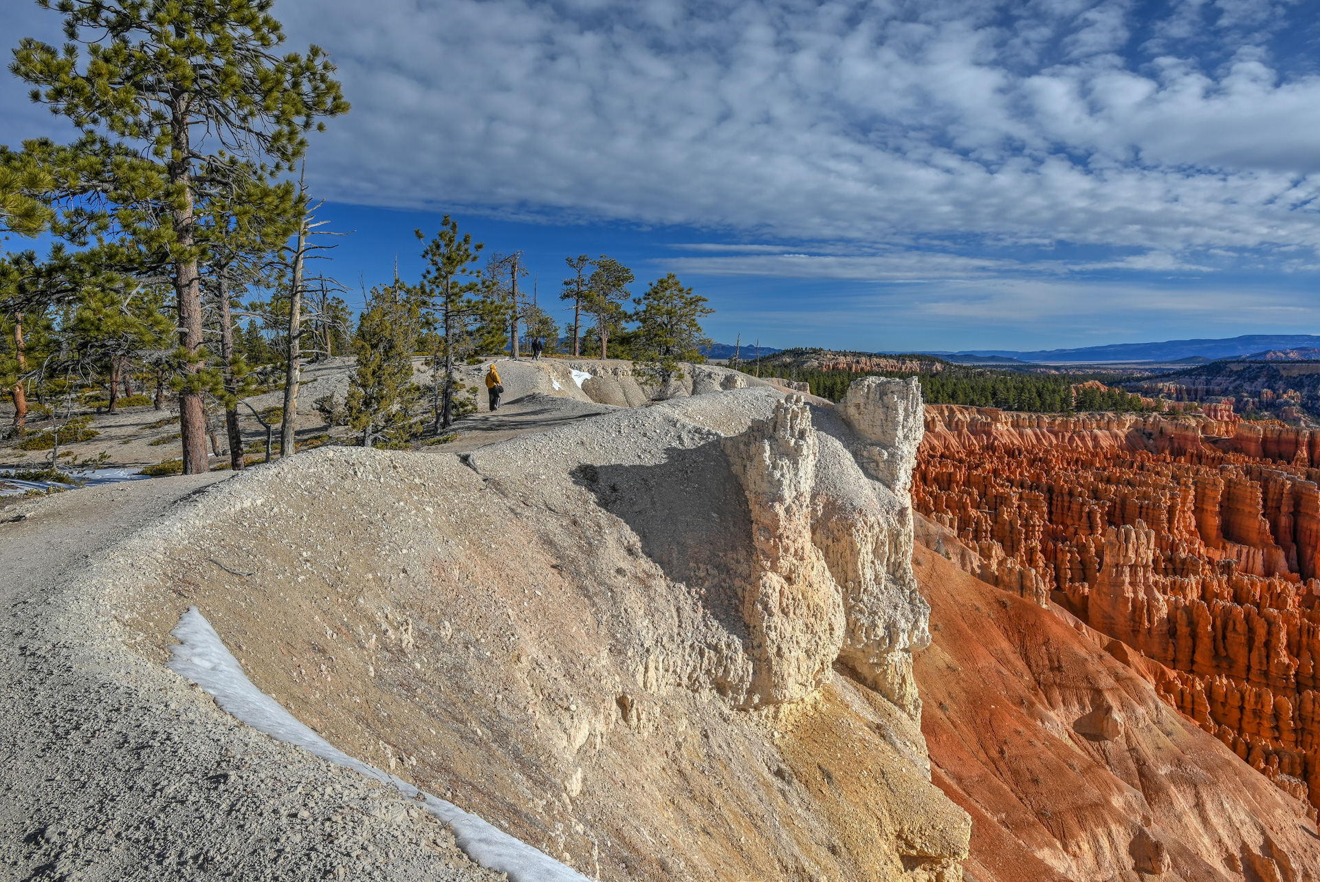
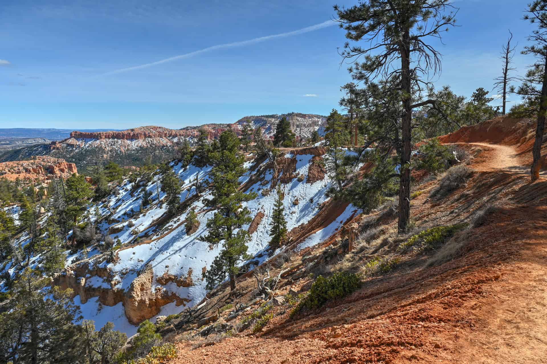
While Sunrise Point can also feel busy, it marks a transition into a slightly quieter section of the rim. Beyond Sunrise Point, there are no additional official viewpoints along the Rim Trail until Fairyland Point, which lies roughly three miles farther north. That said, this stretch of trail is often less crowded and still offers excellent views, though more of distant rock formations and landscapes than the up close views of the hoodoos you’ve enjoyed up until this point (including a great view of the ridgeline on which lies the Queen’s Garden Trail — see the first picture below). We find it’s a pleasant area to explore if you want a bit more breathing room away from the main viewpoint clusters.


As for where to stop, that’s entirely up to you. A natural turnaround point is near the North Campground, close to the junction with the Fairyland Loop and Tower Bridge Trail. Beyond this area, the Rim Trail begins to gain more noticeable elevation and feels less like a casual stroll, making it a good place to wrap up a relaxed amphitheater walk.
Rim Trail – Additional Details and Hiking Tips
Canine companions: Dogs are only permitted on the short paved section of the Rim Trail between Sunset Point and Sunrise Point, and must be leashed at all times.
Trail environment: This section of the Rim Trail stays fully along the canyon rim, offering open, elevated views across Bryce’s main amphitheater. The environment feels airy and expansive rather than enclosed, with hoodoos spreading out below in dense clusters. Shade is limited, and most of the walk is exposed to the sun and wind.
Route signage: Navigation is straightforward. The Rim Trail is clearly marked at all major viewpoints, and wayfinding between Inspiration, Sunset, and Sunrise Points is intuitive. Because the trail connects multiple viewpoints, you’ll regularly encounter signage and maps along the route.
Trail surface / Technical aspects: The trail surface is mostly paved or well-compacted dirt, depending on the section. There are no technical obstacles, drop-offs, or narrow ledges along this stretch.
Slope and effort: Most of this section is flat or gently rolling, with the only noticeable climb occurring between Lower and Upper Inspiration Point. Overall effort is minimal compared to Bryce’s below-the-rim trails, and elevation changes are gradual rather than sustained.
Previous Hiking Experience: No hiking experience is required. This section of the Rim Trail is well-suited to first-time visitors, families, and anyone looking for a low-effort way to experience Bryce’s scenery. You can walk at your own pace and turn around at any point.
Cell Service: Cell reception along the rim is generally better than below the rim, with intermittent service available at many viewpoints. Coverage can still be unreliable, so downloading maps ahead of time is recommended, especially if you plan to venture further than the main one-mile amphitheater section.
Leave No Trace: Stay on the designated trail and paved walkways to protect fragile soils near the rim edge. Avoid climbing on rock formations, pack out all trash, and be mindful of other visitors at busy viewpoints.
Bugs: Insects are typically minimal along the rim. Occasional flies may appear in warmer months, but mosquitoes are uncommon. Bug spray is usually unnecessary.
Equipment: No special gear is required. Comfortable walking shoes are sufficient. Bring water, sun protection, and layered clothing, as temperatures and wind conditions can change quickly at elevation.
Weather and Exposure: Bryce Canyon sits at a high elevation, and conditions can change quickly.
- Sun exposure: Strong sun is common, even in cooler temperatures. Sun protection is essential year-round.
- Wind: Breezes are frequent, especially near the rim and open sections of the trail.
- Rain: After storms, sections of the trail can become muddy or slick; allow extra time and watch your footing.
Wildlife: You may see birds, ground squirrels, or mule deer in quieter areas of the trail. Wildlife sightings are usually brief; observe from a distance and do not feed animals.
Current Trail Conditions: Check the Bryce Canyon National Park alerts page before your visit for updates on road closures, tunnel traffic controls, weather impacts, or temporary trail restrictions.
Best Time to Hike the Rim Trail
The Rim Trail is accessible for much of the year, but Bryce Canyon’s high elevation means weather, temperature swings, and seasonal closures play a major role in the experience. Because the trail descends below the rim with minimal shade, timing your hike can make a noticeable difference in comfort and scenery.
Spring (March–May):
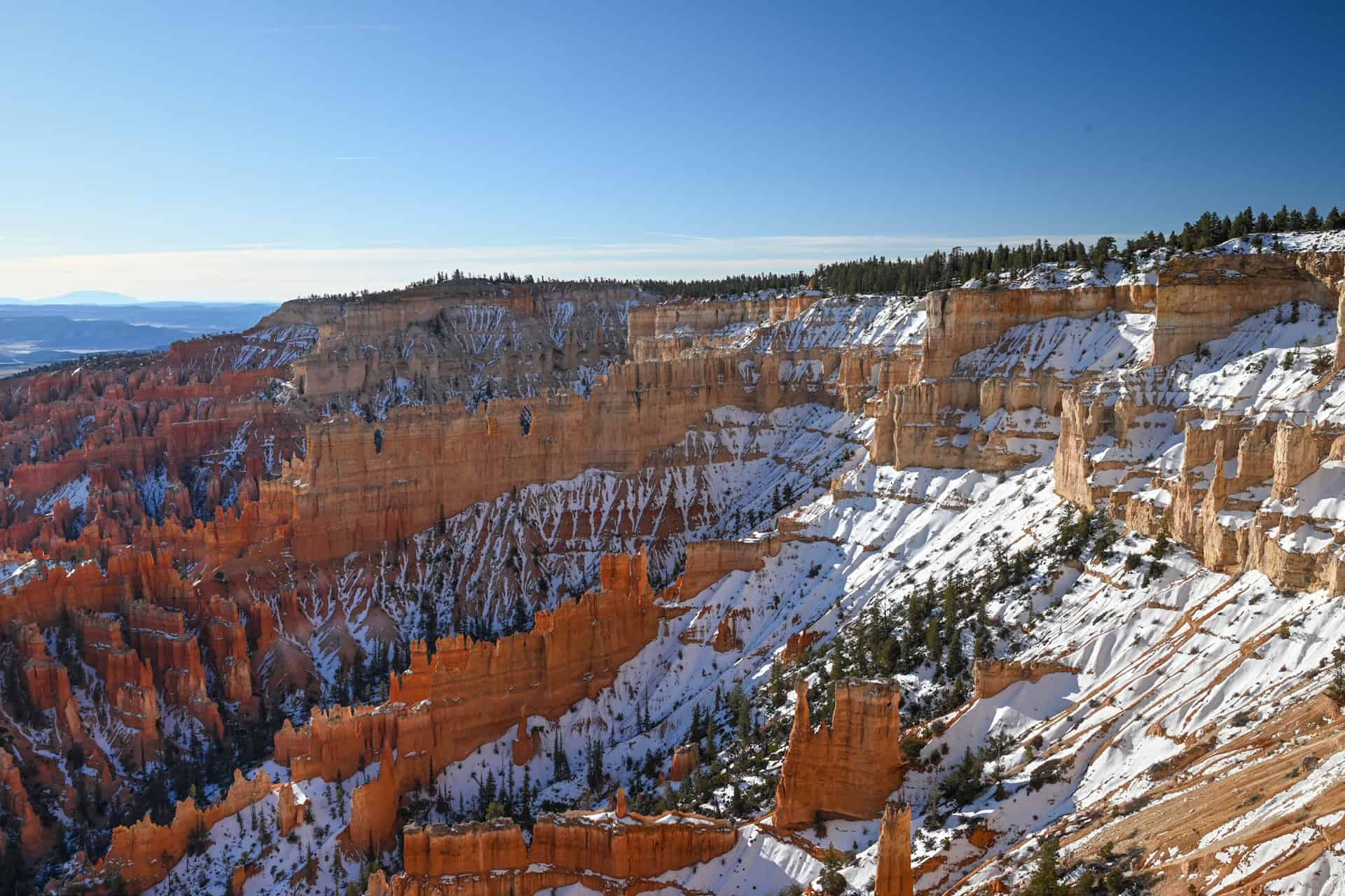
One of the best times to hike the Rim Trail. Daytime temperatures are generally cool to mild, often ranging from 45–65°F (7–18°C), and snow at lower elevations begins to melt. The hoodoos contrast beautifully against lingering patches of snow on the rim, creating some of the most dramatic scenery of the year. That said, spring conditions can be variable—mud, icy patches, and late snowstorms are possible, especially earlier in the season. Microspikes may be helpful in April, and checking trail conditions is essential.
Summer (June–September):
Summer brings the most reliable trail conditions and full access to Bryce Canyon. Daytime highs usually range from 65–80°F (18–27°C), noticeably cooler than Zion due to the park’s elevation. However, the Rim Trail is still largely exposed, and the sun can be intense at altitude. Afternoon thunderstorms are common during monsoon season (July–August), so early morning hikes are strongly recommended for both comfort and safety. Crowds peak in summer, but this trail tends to be quieter than those in the main amphitheater.
Fall (October–November):
Another excellent season for hiking the Rim Trail. Cooler temperatures, typically 45–65°F (7–18°C), make the descent and return climb more comfortable. The lower sun angle adds depth and contrast to the hoodoos, enhancing photography. Crowds begin to thin out after September, and trail conditions are usually stable. By late October, early snow is possible, and some services may begin to scale back.
Winter (December–February):
Snow and ice are common, and sections of the Rim Trail may be snow-covered or slick. With proper traction and warm layers, this stretch of the Rim Trail remains one of the safest and most accessible ways to experience Bryce Canyon in winter, since it avoids steep descents into the amphitheater. Access roads and parking areas can be temporarily closed after storms, so checking conditions before visiting is essential.
Quick Summary – When to Visit
Late spring through early fall offers the best balance of accessibility, scenery, and trail conditions. Summer provides the most reliable footing but comes with crowds and strong sun, making early starts ideal. Spring and fall deliver cooler temperatures and fewer people, but require flexibility due to changing weather. The Rim Trail remains one of the park’s best winter options.
Hiking Packing List
All Trails subscription – This comes in really handy for areas with little or no cell reception, as the annual subscription allows you to download trail maps for offline use.
External Battery – If you are using your phone to track your progress along the trail or to help with navigation, you certainly don’t want your phone to die on you. That’s especially true in the unlikely event that you might get hurt or need assistance.
Hiking poles – These can be particularly useful in steep trails or muddy/boggy trail conditions.
Water Filter Bottle – The Life Straw bottle is an advanced water bottle with a filter that not only improves water taste but more importantly filters out bacteria and parasites, chemicals and microplastics.
Headlamp – very practical and a smart choice if you plan to start your hike before sunrise or finish it after sunset.
Is the Rim Trail Worth It?
We definitely think so! It’s easily one of our favorite hikes to do in Bryce, and it provides a fantastic bang for your buck. For very little effort, you are rewarded with non-stop stunning views of Bryce Canyon’s amphitheater.
Why You Might Enjoy It:
– Continuous, unobstructed views across Bryce’s main amphitheater
– Easy to customize: walk a short segment or link multiple viewpoints together
– Minimal elevation change
– Ideal for winter or shoulder seasons when below-the-rim trails may be icy or muddy
Why It Might Not Be for You:
– You won’t be walking among the hoodoos or descending into the canyon
– Less of a “hike” and more of a scenic walk, which may not appeal to experienced hikers seeking challenge
– Viewpoints along this section can still be busy, especially mid-day
– Limited shade and frequent wind exposure along the rim
Bottom line: If you want big views, easy walking, and maximum flexibility, the Rim Trail is absolutely worth your time. It’s one of the most efficient ways to experience Bryce Canyon’s core scenery and pairs especially well with a below-the-rim hike on another day—or later the same day.
Want to Know More About Bryce National Park?
We’ve put together a dedicated Bryce Canyon National Park Guide that covers the park’s most iconic viewpoints, the scenic drive along the rim, and the best ways to experience the hoodoos both from above and below. It’s designed to help you plan a balanced visit, whether you’re stopping for a day or building Bryce into a longer southern Utah road trip. We’ve also created detailed hiking guides for two of Bryce’s most classic trails:
Tower Bridge Trail
The Tower Bridge Trail offers a quieter way to experience Bryce Canyon from below the rim, descending into a more open, less crowded section of the amphitheater. The trail leads to the striking Tower Bridge formation, a natural arch framed by tall hoodoos, and provides a different perspective than the park’s rim viewpoints. While it requires more effort than a rim walk, it rewards hikers with immersive scenery and fewer crowds than trails like Navajo Loop and Queen’s Garden. For route details, access information, and hiking tips, see our Tower Bridge Trail Hiking Guide.


Navajo Loop & Queen’s Garden Trail
Often considered Bryce Canyon’s signature hike, this loop descends directly into the heart of the amphitheater, weaving through dense clusters of hoodoos, narrow corridors, and towering rock walls. The combination of the steep Navajo Loop descent with the gentler Queen’s Garden exit creates a varied and immersive route that showcases Bryce at its most dramatic. It’s busier than Tower Bridge, but for many visitors, it’s the most memorable way to experience the park from below the rim. For route details and planning advice, see our Navajo Loop & Queen’s Garden Trail Hiking Guide.


Where to Stay Near Bryce Canyon National Park
If your goal is to maximize time in Bryce Canyon and keep logistics simple, staying just outside the park entrance is the most practical option. Lodging in this area allows for early starts, easy access to sunrise viewpoints, and minimal driving once you’re in the park—especially useful during busy months or when weather conditions change quickly.
Rather than spreading options across multiple towns, we recommend basing yourself as close to the entrance as possible.
Best Western Plus Ruby’s Inn
Best Western Plus Ruby’s Inn is located directly outside Bryce Canyon National Park’s main entrance, making it one of the most convenient places to stay. Rooms are comfortable and well-maintained, and the property includes a restaurant, general store, outdoor pool, and laundry facilities.
Its location makes early morning and late evening visits to the rim especially easy, whether you’re catching sunrise, returning after sunset, or timing hikes around changing weather. Ruby’s Inn also serves as a hub for Bryce Canyon’s shuttle system during the operating season, further simplifying access to viewpoints and trailheads.
Booking tip: Bryce Canyon accommodations are limited, and Ruby’s Inn fills quickly during peak season (late spring through fall). Reserving well in advance is strongly recommended, especially if you plan to visit during the summer or on weekends.
Rim Trail – Frequently Asked Questions (FAQ)
Is the Rim Trail difficult?
No. This section of the Rim Trail is mostly flat with minimal elevation change. Aside from a short climb between Lower and Upper Inspiration Point, it’s an easy walk suitable for most visitors.
How long does it take to walk this section of the Rim Trail?
Most people spend 45 minutes to 1.5 hours, depending on pace, how often you stop for photos, and where you choose to turn around. The trail is easy to customize.
Do you need to hike the entire Rim Trail?
Not at all. The full Rim Trail is much longer, but most visitors focus on short sections near the amphitheater. This guide covers the most scenic and accessible one-mile stretch.
Is the Rim Trail crowded?
Viewpoints like Sunset and Sunrise Point can be busy, especially mid-day. However, the trail segments between viewpoints are often noticeably quieter, particularly in the early morning or late afternoon.
Can you walk the Rim Trail in winter?
Yes. This section of the Rim Trail is one of the best winter options in Bryce Canyon. Snow and ice are common, so traction devices are recommended, but the lack of steep descents makes it safer than below-the-rim trails.
What’s the best time of day to walk the Rim Trail?
Early morning and late afternoon are ideal for softer light, cooler temperatures, and fewer people. Sunrise and sunset are especially popular, but also the busiest.
Are drones allowed?
No. Drones are not permitted anywhere in Bryce Canyon National Park. This applies to both recreational and commercial drone use. The restriction helps protect wildlife, preserve the natural soundscape, and ensure visitor safety.
Explore More Utah National & State Park Guides
Continue exploring Utah with these detailed guides:
Zion National Park Guide
Capitol Reef National Park Guide
Snow Canyon State Park Guide
Goblin Valley State Park Guide
Monument Valley Guide
Photography Gear
If you like our photography, you might be interested in some of the gear we use to shoot our travel and hiking destinations.
Camera Body – Nikon Z 6ii Fx-series Mirrorless Body
Main Lens – NIKON 24-120mm F/4G ED VR AF-S
Zoom Lens – Sigma 745-306 150-600mm f/5-6.3
Polarizing filters – Urth Circular Polarizing (CPL)
Camera Tripod – K&F Concept 64-inch Camera Tripod
Mini-tripod – Lammcou Flexible Camera Tripod
Camera/hiking backpack – Vanguard Alta Rise 48 Backpack
Universal Travel Adapter – VYLEE Universal International Power Travel Plug
Other Travel Essentials
Travel Insurance
SafetyWing is a travel insurance company that offers comprehensive coverage for travellers. Includes Medical Insurance and Travel Insurance. Primarily geared towards long-term travellers, digital nomads, and expats.
e-Sim cards
Airalo is the world’s first and largest eSIM store with eSIM plans for 200+ countries and regions worldwide. With Airalo eSIMs, travellers can get connected the moment they land at their destination and avoid nasty data roaming charges
eSIMS are a sustainable alternative to single-use SIM cards – they are 100% digital, require less energy to produce and be re-used rather than disposed of.
Car Rentals
Discover Cars is our go-to website for car rentals. We almost always find our preferred rate there.
Transfer from Airport
Welcome Pickups is our favourite private transfer service, which you can pre-book at a fixed price. Currently available in 220 cities all over the world (mostly in Europe, but with several major cities in Asia, the Middle East and the US).
Kiwitaxi is another private transfer service – we haven’t tried it yet, but it’s currently available in a few more countries (102 as of 2024).
Hotels and Accommodations (coming soon)
Photography Prints
If you found this blog useful, you can help support our blog by purchasing low-cost digital prints. Printed physical prints are also available for purchase.


—–
Well, that wraps it up! We hope you enjoyed our Bryce Canyon National Park Hiking Guide for The Rim Trail and that it will prove useful for planning your trip.
—–
You might also be interested in these related pages: