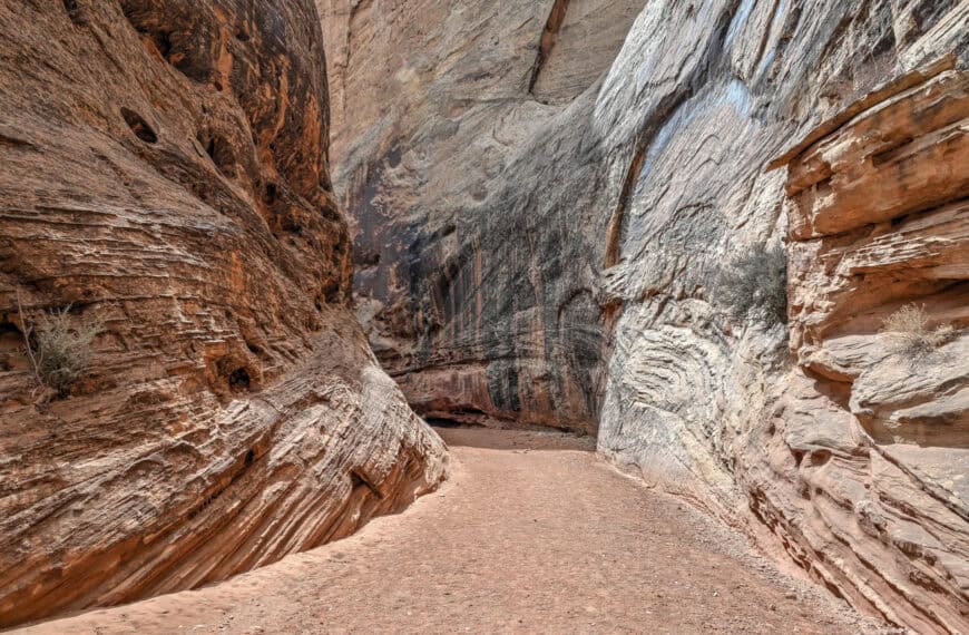
Zion National Park sits in the southwest corner of Utah, where the Virgin River has carved a deep canyon through layers of Navajo sandstone, creating one of the most dramatic landscapes in the American Southwest. The park is best known for its towering canyon walls, narrow slot canyons, and high sandstone plateaus, with a trail network that ranges from short riverside walks to strenuous climbs along exposed cliffs. Unlike many parks that can be seen in a single day, Zion rewards a slower pace, whether you’re exploring classic hikes like Angels Landing and The Narrows or venturing into quieter corners beyond Zion Canyon. This guide brings together the park’s best hikes, viewpoints, and planning advice to help you decide how to structure your time in Zion, whether you have a couple of days or a longer stay.
Zion National Park Highlights – At a Glance
West Rim Trail (including Scout Lookout and Angels Landing) – Zion’s most iconic route climbs steadily from the canyon floor through Refrigerator Canyon through a series of relentless switchbacks before reaching Scout Lookout, with the option to continue onto the exposed spine of the Angels Landing spur trail or to continue further along the West Rim trail. Even if you don’t continue beyond Scout Lookout, the West Rim delivers classic canyon views and a real sense of Zion’s vertical scale.
East Mesa to Observation Point – One of the less physically demanding ways to reach one of Zion’s best viewpoints, this moderately long but easy out-and-back hike leads across open plateau terrain to a sweeping overlook high above Zion Canyon, and high above Angels Landing, without its exposure or crowds.
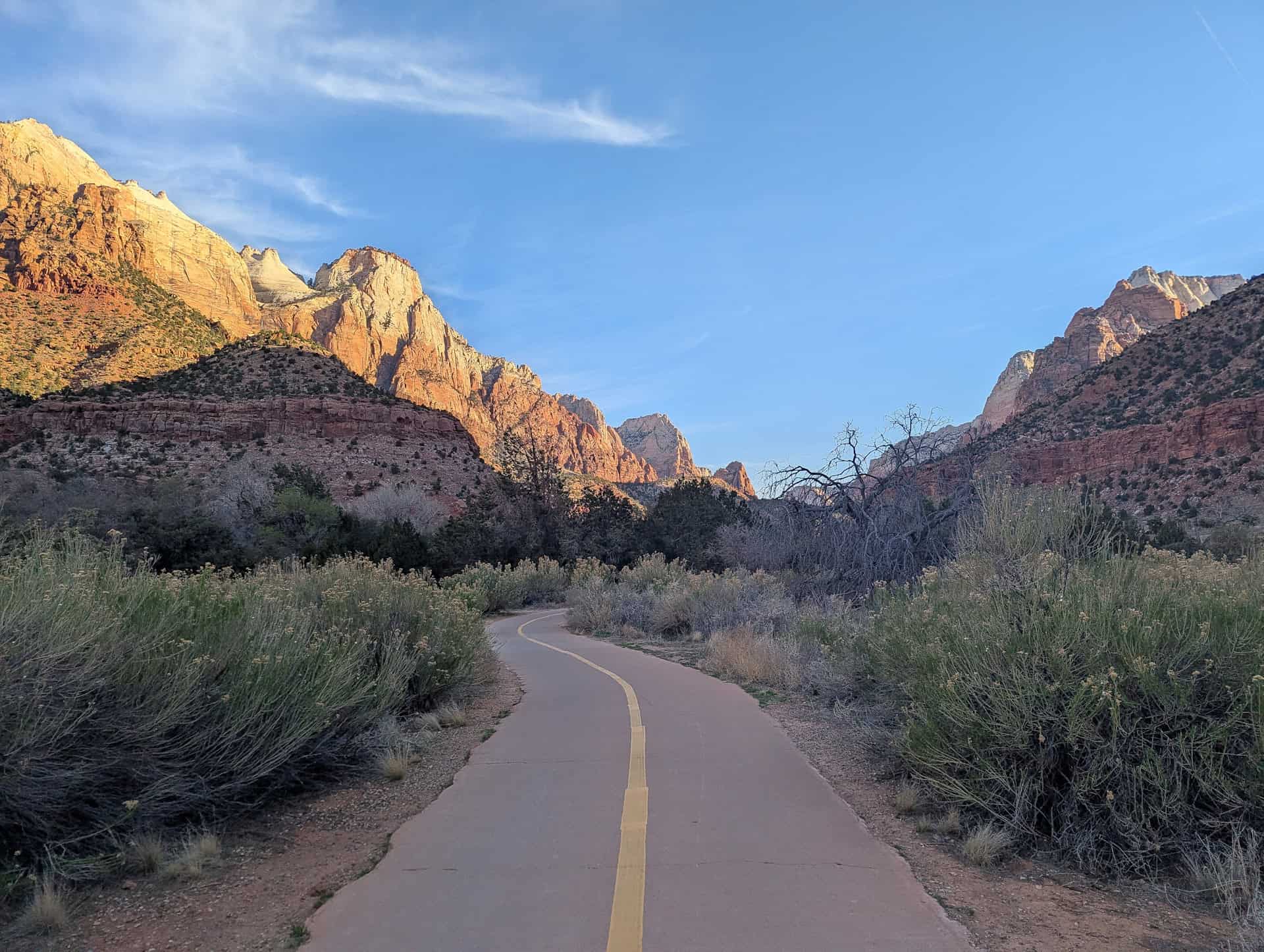
The Watchman Trail – A steady climb near the park’s south entrance that rewards hikers with elevated views over Springdale, the Virgin River, and the lower canyon. It’s especially popular near sunset, not overly long nor difficult, and is accessible from the west entrance visitor center (you don’t need to drive or take the shuttle to the trailhead)
Canyon Overlook Trail – Steep but very short, this trail packs a lot into a small distance, ending at a dramatic viewpoint above Pine Creek Canyon. It’s one of the easiest ways to access a high vantage point, particularly if you’re short on time, although parking can be a challenge.
Emerald Pools – A network of trails leading to shaded alcoves, seasonal waterfalls, and reflective pools beneath towering cliffs. While less rugged than some of Zion’s marquee hikes, Emerald Pools offers a cooler, greener side of the park and is well-suited to a more relaxed walk. However, these easier trails are quite popular, and they get crowded at times.
A park built for longer stays – Zion’s main canyon concentrates many of its highlights, but the park’s scale and variety definitely reward visitors who slow down. With multiple trails, scenic drives, and viewpoints spread across different elevations, Zion lends itself to multi-day visits rather than a single rushed stop, and we’ll provide some itinerary suggestions to help plan your stay.


Disclosure: This page (Zion National Park Guide) may contain product affiliate links. At no additional cost to you, we may receive a commission for purchases made through these links. More details can be found on our disclosure and policies page.
Zion National Park Location and Map
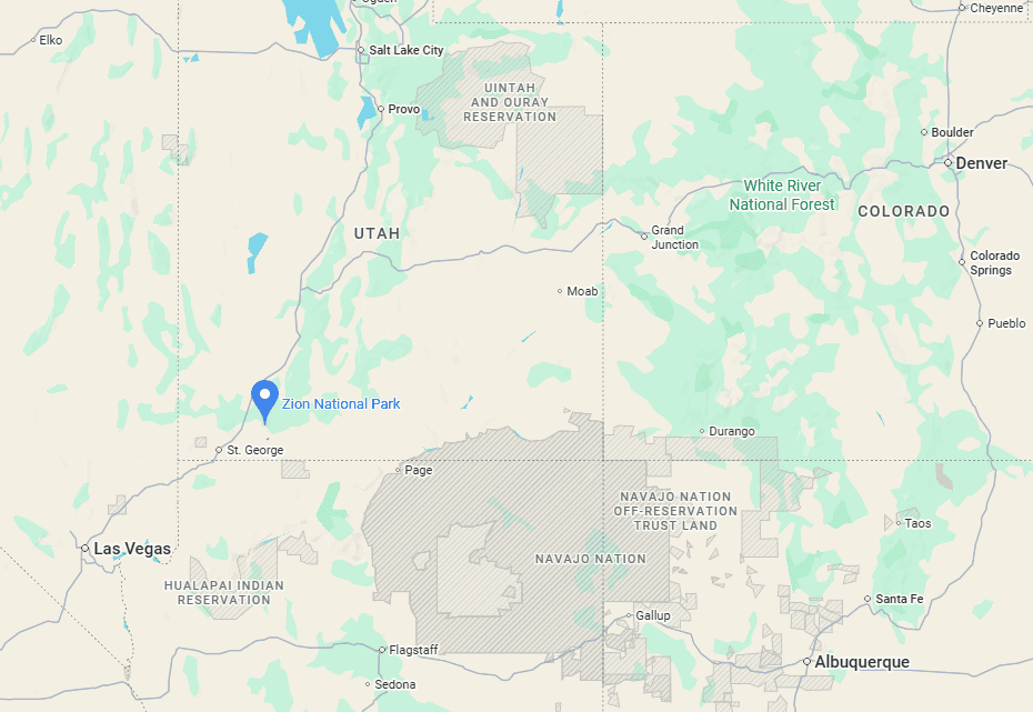
Zion National Park is located in southwestern Utah (link to Google Maps), just a short drive north of St. George and approximately two and a half hours from Las Vegas. Easily accessible from Interstate 15, Zion works well as the centerpiece of a multi-day Utah itinerary or as a stop along a longer drive through southern Utah’s canyon country.
How to Get to Zion National Park
If you are staying in Springdale, many hotels are within walking distance of the park’s south entrance, and the town shuttle provides easy access to the visitor center and park shuttle stops. If arriving from Las Vegas, Salt Lake City, or other parts of southern Utah, you will find the drive straightforward, with Interstate 15 providing the main access route to the region.
Driving times to Zion National Park
- Las Vegas, NV: 260 km / 160 mi – about 2.5 hours
- St. George, UT: 70 km / 45 mi – about 1 hour
- Bryce Canyon National Park: 135 km / 85 mi – about 2 hours
- Page, AZ: 175 km / 110 mi – about 2.5 hours
- Flagstaff, AZ: 420 km / 260 mi – about 4.5 hours
These times assume clear weather and normal traffic conditions.
Zion National Park has two main entrances, both accessible by paved roads:
South West Entrance (Springdale):
This is the main access point for Zion National Park and where the majority of visitors begin their trip. It provides direct access to Zion Canyon, the shuttle system, and popular trails such as Angels Landing, The Narrows, Emerald Pools, and the West Rim Trail. If you’re spending most of your time in the main canyon, this is where you’ll enter the park.
East Entrance (via Highway 9):
The east entrance is quieter and more scenic, passing through slickrock domes and sandstone formations before reaching the Zion–Mount Carmel Tunnel. The Canyon Overlook Trail is located near this entrance, making it especially convenient for visitors approaching from Bryce Canyon, Page, Kanab, or Monument Valley.
Regardless of which entrance you use, all main roads inside the park are paved and suitable for any vehicle.
If you need to book a rental vehicle for your roadtrip, we highly recommend using Discover Cars to get the best rates on your rental in Utah, Nevada and Arizona.
We also highly recommend Airalo (eSIM card) for your connectivity needs when travelling abroad. Airalo is the world’s first and largest eSIM store with eSIM plans for 200+ countries and regions worldwide.
Group Excursion from Vegas
Alternatively, if you don’t have a car and are staying in Las Vegas, you can still visit Zion National Park by joining an organized tour from the city. Several companies offer full-day excursions. This is the most popular tour, which allows for 6 hours of free time in the park:
Zion National Park Entry Fees
Anyone visiting Zion National Park, whether to hike, take a scenic drive, or simply enjoy the views, must pay the applicable entrance fee to the National Park Service.
Entrance Fees (per vehicle, valid 7 days)
Private vehicle: $35
Motorcycle: $30
Individual (on foot, bicycle, etc.): $20
Annual Pass Options
Zion Annual Pass: $70 – unlimited entry for one year from the month of purchase.
America the Beautiful Pass: $80 – valid for one year at all U.S. National Parks and more than 2,000 federal recreation sites nationwide. This is the best value if you plan to visit multiple national parks within a year.
Passes can be purchased at the park entrance stations, the Visitor Center, or online through the USGS website or via the REI store.
—> Most visitors exploring Utah’s “Mighty 5” parks (Arches, Bryce Canyon, Canyonlands, Capitol Reef, and Zion) should strongly consider the America the Beautiful Pass—it saves money and avoids the hassle of buying separate entry fees at each park.
Zion National Park – Access, Navigation, Parking, and Facilities
Park Opening Hours: Zion National Park is open year-round, 24 hours a day. Most visitor services operate on a more limited schedule, however.
Visitor Center: The Zion Canyon Visitor Center sits near the south entrance, adjacent to the town of Springdale. It offers exhibits on the park’s geology, ecology, wildlife, and human history, as well as maps, permits, and ranger guidance. It is typically open from 8:00 a.m. to 5:00 p.m., but hours may vary seasonally and on holidays. For the most up-to-date information, see the park’s official website.
Park Navigation: Zion is structured around the main canyon carved by the Virgin River, which runs roughly north to south. The park road along the canyon floor (Zion Canyon Scenic Drive) is the central artery, connecting most trailheads, shuttle stops, and scenic viewpoints. Many of the park’s most popular hikes start along this route.
During the high season (typically March through late November), private vehicles are not permitted on Zion Canyon Scenic Drive, and visitors must use the park shuttle system to access key trailheads and viewpoints. The Zion Canyon Shuttle is free, reliable, and operates roughly every 7–15 minutes, depending on the season and time of day. To reach any trailhead, simply board the shuttle at one of the main stops or the Visitor Center. Outside of shuttle season, the road is open to private vehicles.
In contrast, the road connecting the south and east entrances—via the Zion–Mount Carmel Highway and tunnel—remains open to private vehicles year-round, weather permitting. This scenic drive climbs steeply from the canyon floor, passes through the historic tunnel, and descends into slickrock and high desert terrain east of the park. It provides access to the Canyon Overlook Trail and serves as an important through-route for travelers driving between Zion, Bryce Canyon, and the wider Utah canyon region.
Parking: If visiting during off-peak months, drivers will find that nearly all viewpoints and trailheads have dedicated parking lots, though they can fill up quickly on busy weekends and holidays.
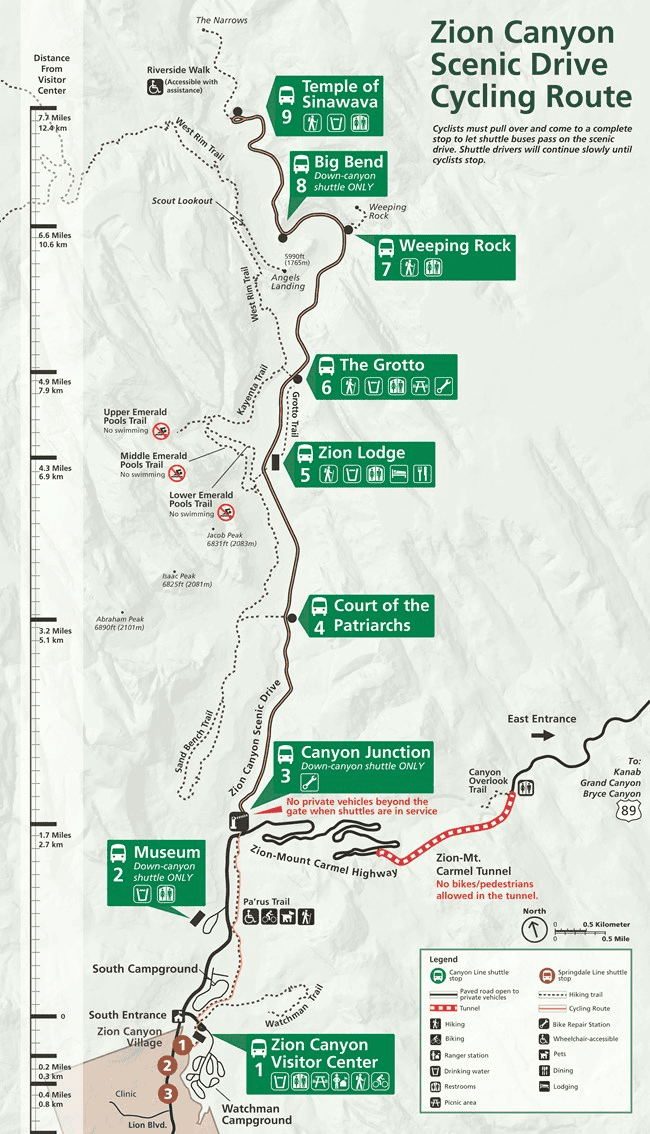
Picnicking/Day Use/Toilets: Picnic areas and restrooms are located at several points along the canyon, including the Zion Lodge, The Grotto, Big Bend, and Temple of Sinawava (see map below in the next section). Day use does not require reservations, and most amenities are concentrated along the main canyon corridor.
Camping: Zion has three main campgrounds—South, Watchman, and Lava Point. South and Watchman campgrounds are located near the south entrance, within easy reach of the main canyon, while Lava Point is more remote. Campsites offer tables, grills, water, and restrooms, and all require reservations. A maximum stay of 14 nights in a 30-day period is enforced.
Zion Main Canyon Layout (Map) and Shuttle Stops
The map below highlights the 9 shuttle stops along Zion Canyon Scenic Drive, in addition to the trails and facilities available at each.
Zion National Park – Some Quick Facts
Establishment: Zion was designated a national park in 1919, making it Utah’s first. The park was established to protect the dramatic sandstone canyons carved by the Virgin River, along with the region’s unique ecosystems and long human history.
Visitor Numbers: Zion is one of the most visited national parks in the United States. Crowds are highest in spring and fall, with summer also very busy around the main canyon and shuttle corridor. Winter is noticeably quieter, though lower-elevation trails remain accessible.
Size: The park covers roughly 147,000 acres (59,000 hectares), encompassing deep canyons, high plateaus, and remote backcountry areas. While many visitors focus on the main canyon, much of Zion lies away from the shuttle corridor.
Elevation: Zion’s elevation ranges from about 3,700 feet (1,130 m) at the south entrance to over 8,700 feet (2,660 m) on the higher plateaus. This wide elevation range creates varied climates within the park, from desert conditions in the canyon to cooler, forested terrain at higher elevations.
Geology: Zion’s landscape is dominated by the Navajo Sandstone, formed from ancient sand dunes around 170 million years ago. Over time, uplift and erosion by the Virgin River carved the steep canyon walls, alcoves, and narrow gorges seen today. The park also preserves evidence of earlier human presence, including archaeological sites and rock art left by ancestral peoples.
Zions’ Best Hiking Trails
“Best” is obviously a subjective label, especially in a park with as many trails as Zion. The five hikes listed here are our personal picks, chosen for their scenery, variety, and overall experience. Later in the guide, we also cover other well-known Zion trails and explain why they didn’t make this list.
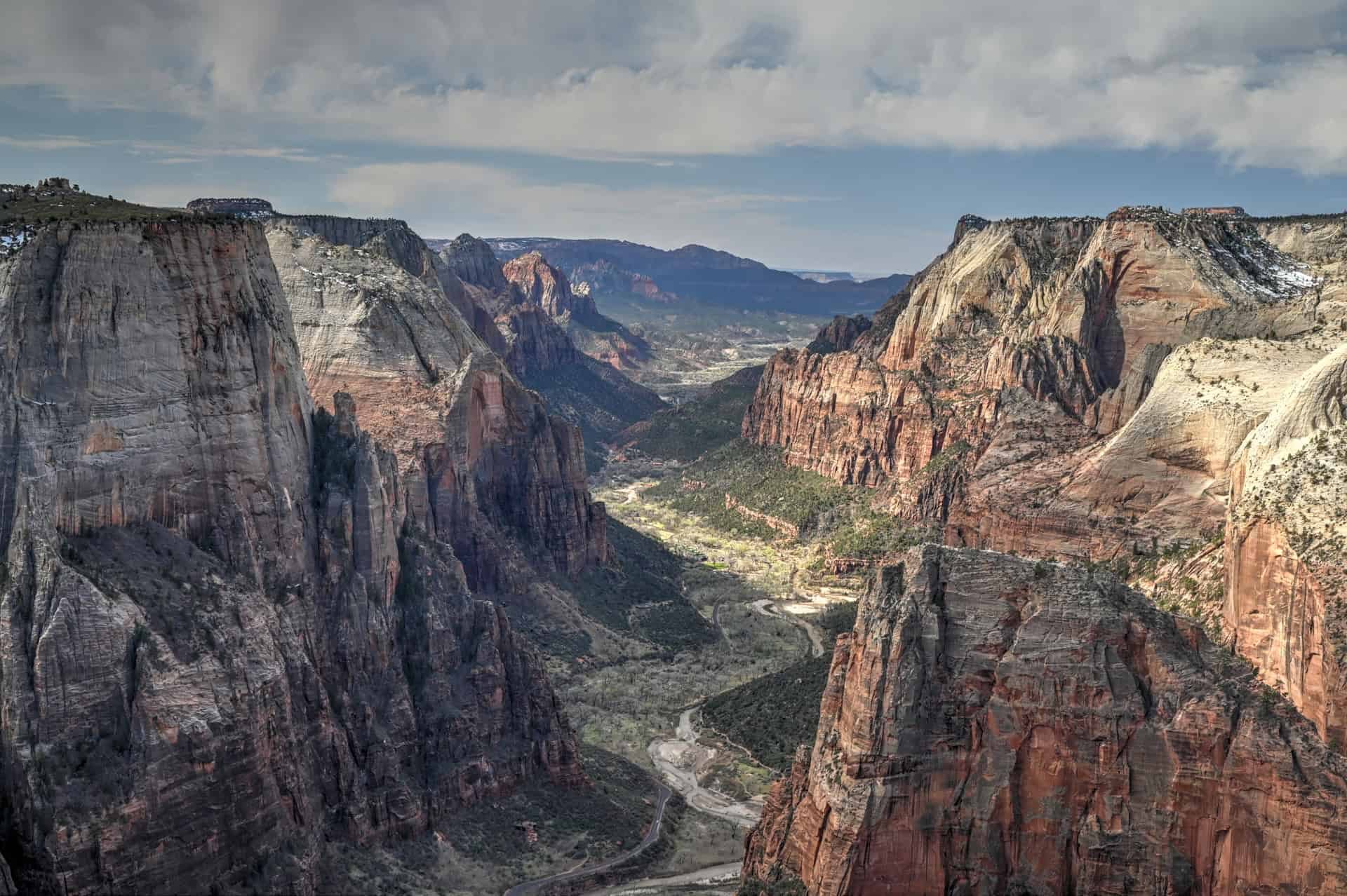
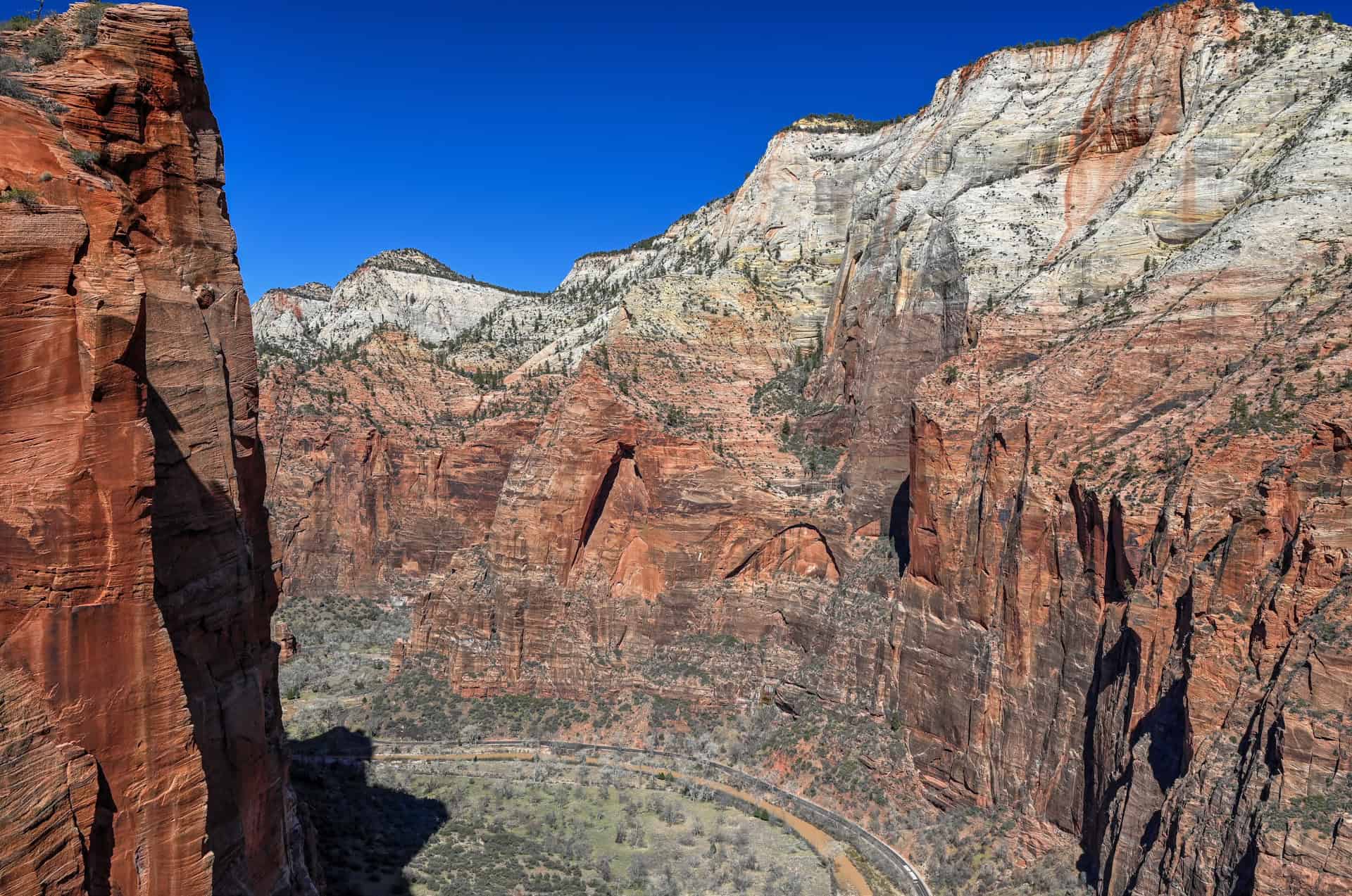
West Rim Trail (Scout Lookout and Angels Landing)
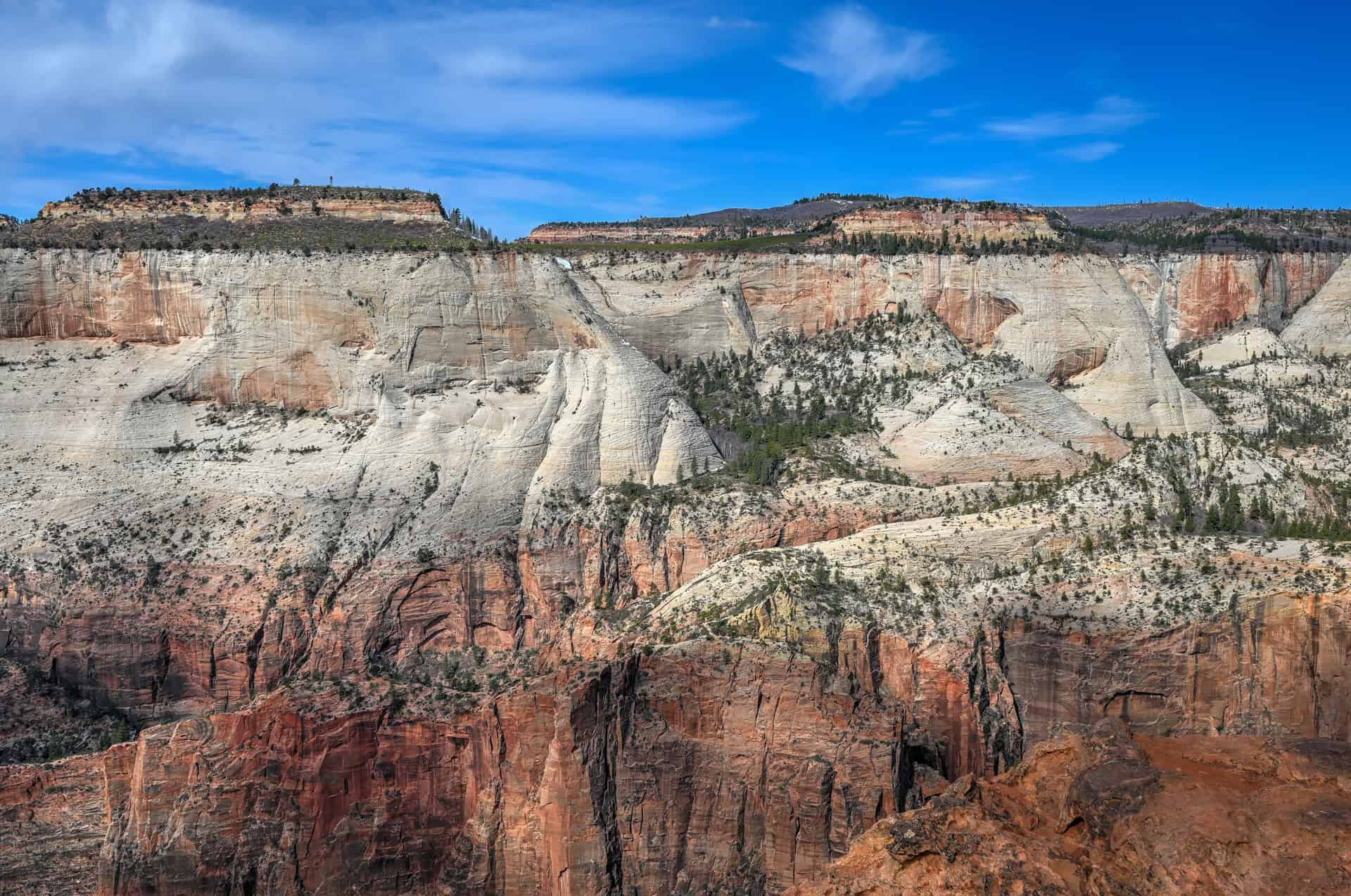
If you want to experience Zion’s vertical scale and classic canyon views, the West Rim Trail is one of the park’s defining hikes. The route climbs steadily from the canyon floor through a series of long switchbacks, gaining elevation quickly and opening up broad views over Zion Canyon. As the trail rises, the sense of height becomes increasingly apparent, with steep sandstone walls dropping away below.


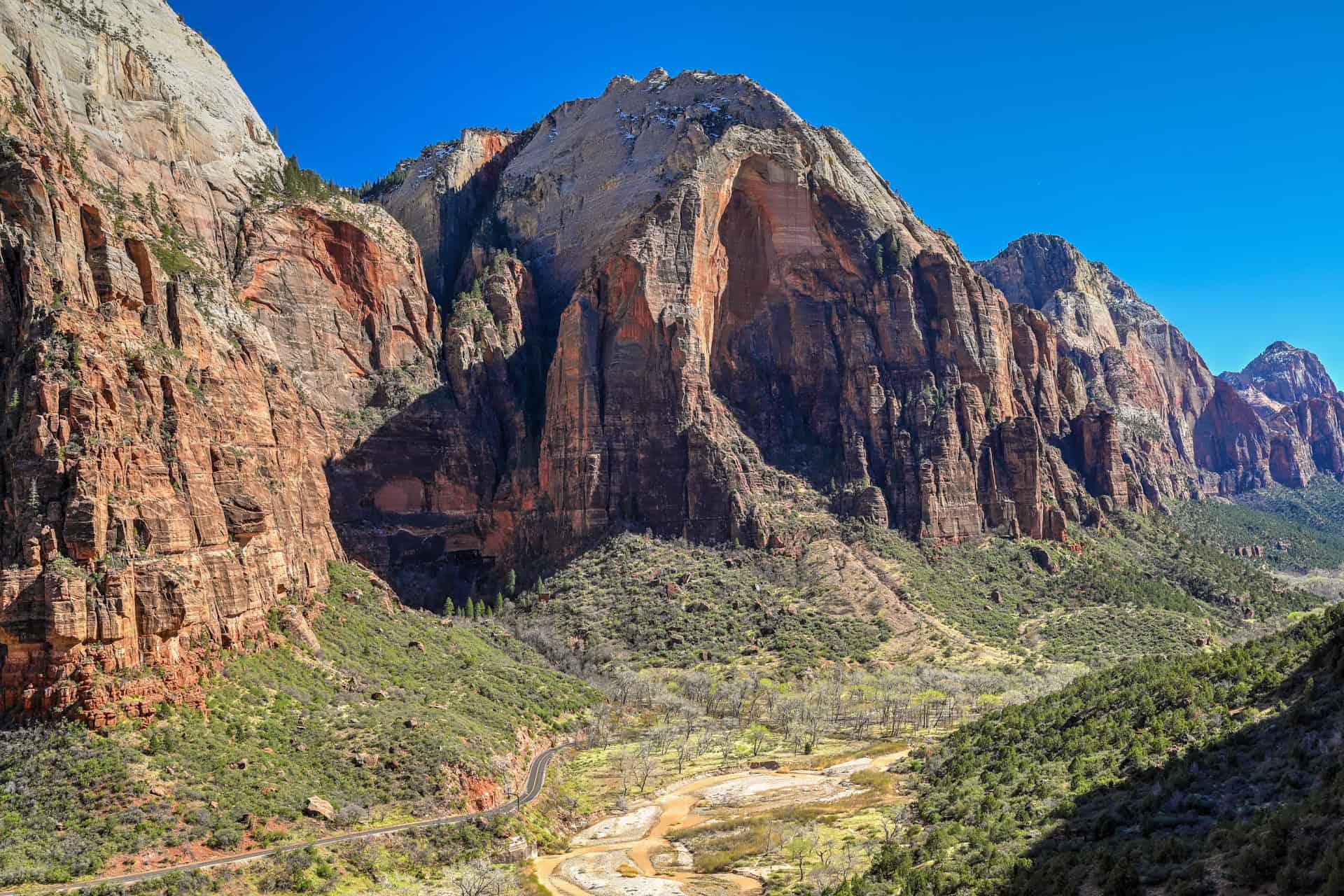
Scout Lookout marks the junction with Angels Landing and offers one of the best viewpoints in the park. From this exposed perch, the canyon stretches out in both directions, with sheer cliffs, narrow side canyons, and the Virgin River far below. The optional Angels Landing spur continues along a narrow sandstone fin with fixed chains, leading to one of Zion’s most famous summits. Beyond Scout Lookout, the West Rim Trail continues into quieter terrain, where crowds thin and views remain expansive as the trail follows the canyon rim.
Highlights: Outstanding views for much of the hike, iconic Zion scenery, and quieter stretches beyond Scout Lookout
Potential drawbacks: Significant elevation gain, heavy crowds on the lower sections, and exposure along the Angels Landing spur
Location: Zion Canyon, shuttle stop #6 (The Grotto)
Difficulty: Moderately challenging, primarily due to sustained elevation gain
Important to know: A permit is required to hike the Angels Landing spur, but not to reach Scout Lookout or continue along the West Rim Trail
For detailed trail information, route descriptions, and photos, see our West Rim Trail Hiking Guide, which breaks down each section of the hike and explains how the Angels Landing permit system works. Whether or not you continue onto Angels Landing, the West Rim Trail remains one of the most rewarding hikes in Zion.
East Mesa Trail to Observation Point
For one of the highest and most expansive viewpoints in Zion without the sustained elevation gain of other routes, the East Mesa Trail to Observation Point is an excellent choice. This relatively gentle hike crosses open pinyon–juniper forest on the park’s eastern plateau before reaching the rim of Zion Canyon, where the ground drops away abruptly and the view opens to the full breadth of the main canyon below.


From Observation Point, Angels Landing appears far beneath you, with Zion Canyon stretching in both directions and layers of sandstone walls receding into the distance. The trail involves minimal exposure and follows a mostly level path, making it a calmer alternative to the steep, canyon-side approaches. With fewer crowds and a quieter setting, this route is a perfect choice for anyone looking for spectacular views without the intensity of Zion’s more strenuous climbs.
Highlights: One of the highest viewpoints in the park, sweeping canyon-wide views, and a relatively gentle trail
Potential drawbacks: Less dramatic terrain along the approach, and it is longer than most other trails in the park
Location: East side of the park (accessed via the Zion–Mount Carmel Highway), roughly an hour from Springdale
Difficulty: Moderate, mostly due to the trail’s length rather than the elevation gain
Important to know: Trail access depends on road conditions, and the trailhead is reached by either a short drive on dirt roads, which can be impassable in wet conditions, or using the East Zion Adventures shuttle service (ideally booked in advance).
For detailed trail information, route descriptions, and photos, see our East Mesa to Observation Point Hiking Guide, which covers trailhead access options and what to expect along the trail.
Watchman Trail
The Watchman Trail offers a steady climb to an elevated viewpoint near Zion’s south entrance, with views that improve gradually as the trail gains height. Unlike many of Zion’s deeper canyon hikes, this route looks outward over Springdale, the Virgin River, and the lower reaches of the park, giving a different perspective on Zion’s landscape.


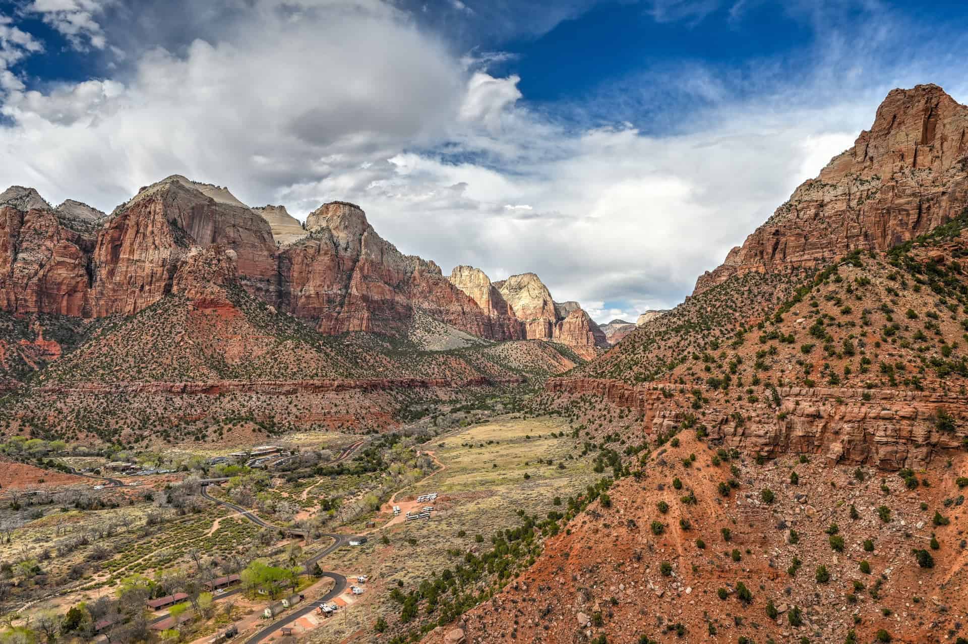
From the upper sections of the trail, the Watchman’s rugged sandstone peak dominates the view, while the town of Springdale and the canyon floor spread out below. The trail is exposed and can feel hot in warmer months, but its relatively short length and convenient location make it a good option for arrival or departure days. It’s especially popular in the late afternoon, when softer light highlights the surrounding cliffs. While it lacks the scale of Zion’s longer canyon hikes, the Watchman Trail delivers rewarding views with minimal time commitment and easy access.
Highlights: Elevated views over Springdale and the lower canyon, convenient and easy access near the park entrance
Potential drawbacks: Fewer dramatic canyon walls compared to deeper Zion hikes
Location: Near the south entrance, Zion Canyon, shuttle stop #1 (Visitor Center)
Difficulty: Easy-to-Moderate, with a steady but manageable climb
Important to know: The trail is fully exposed for much of its length and can be very hot in summer
For detailed trail information, route descriptions, and photos, see our Watchman Trail Hiking Guide.
Canyon Overlook
The Canyon Overlook Trail is a compact but dramatic hike that rewards with one of the most iconic viewpoints near the east entrance of Zion. In just under a mile, the trail ascends over ledges and small rock formations before opening onto a vantage point overlooking Pine Creek Canyon and the lower reaches of Zion Canyon.


Its convenient location near the east entrance makes it an ideal hike for those arriving at or departing from the park.
Highlights: High-impact views in a short hike, easily accessible
Potential drawbacks: Can be crowded due to its proximity to the east entrance and popularity; some sections are exposed and uneven
Location: East side of the park, near the east entrance, off the Zion–Mount Carmel Highway
Difficulty: Easy-to-Moderate, mostly due to short climbs and uneven footing
Important to know: Parking at the trailhead can be a challenge.
For detailed trail information, route descriptions, and parking tips, see our Canyon Overlook Trail Hiking Guide.
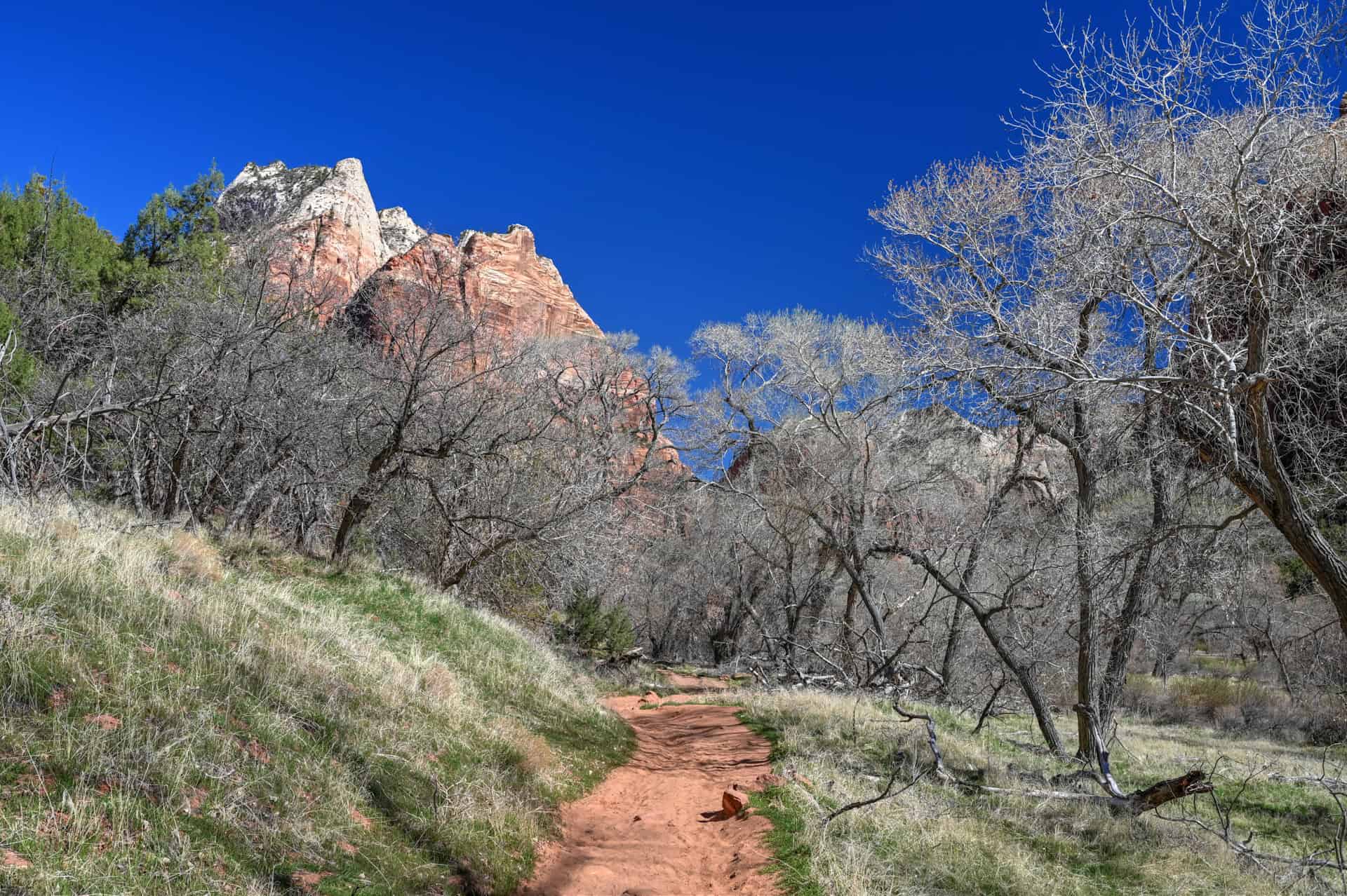
Kayenta Trail
The Kayenta Trail is one of two trails that lead to the Emerald Pools, a series of shaded pools and waterfalls nestled beneath towering sandstone cliffs in the main canyon. Linking the lower, middle, and upper pools, the trail offers a mix of gentle climbs, short switchbacks, and relatively easy terrain, making it accessible for a wide range of visitors.


The trail passes through contrasting scenery: desert scrub along the lower section, narrow alcoves, and dripping cliffs around the middle and upper pools. Seasonal waterfalls can also definitely add to the experience, and the pools themselves provide a cool respite from the canyon sun. This trail is particularly well suited to families or anyone looking for a shorter, less strenuous excursion.
Highlights: Shaded alcoves and seasonal waterfalls
Potential drawbacks: Can be crowded due to its proximity to the main canyon shuttle stops; water levels vary seasonally
Location: Zion Canyon, shuttle stop #6 (The Grotto)
Difficulty: Easy, mostly gentle climbs and a few short staircases. The trail section to the upper pool is more challenging.
Important to know: An easier but slightly less scenic alternative is the Lower Emerald Pool trail, which starts at shuttle stop #5 (Zion Lodge).
For detailed trail information, route descriptions, and photos, see our Kayenta Trail / Emerald Pools Hiking Guide.
Other Hiking Zion Trails
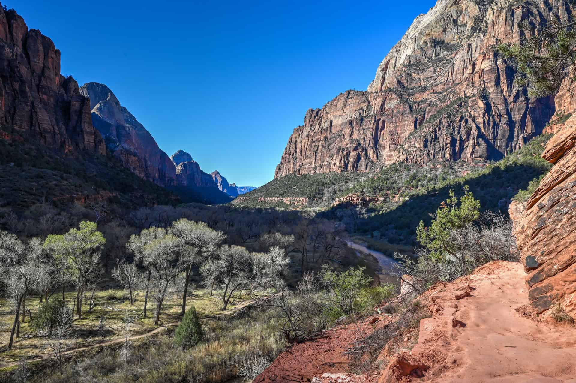
Riverside Walk (shuttle stop #9 – Temple of Sinawava)
A flat, paved trail that connects the Temple of Sinawava shuttle stop to the start of The Narrows. Ideal as a gentle riverside stroll, it offers early glimpses of the Virgin River and surrounding canyon walls, and can be used as a warm-up before tackling The Narrows.

If you visit the trail early in the morning like we did, although you’ll miss out on sunlight with the canyon almost completely in the shade, your likelihood of seeing wildlife is significantly increased. Mule deer are commonly seen along or near the trail, especially in the early morning and late afternoon. Because the trail follows the Virgin River and stays mostly flat and shaded, it attracts animals that come down for water and vegetation.


Pa’rus Trail (park south entrance)
An easy, flat path that follows the Virgin River through the lower canyon. Open to both hikers and cyclists, it provides a convenient, low-effort way to enjoy the canyon floor without venturing onto steeper or more exposed trails. The trail runs from the visitor center all the way to shuttle stop #3.
Emerald Pools Trail (shuttle stop #5 – Zion Lodge)
A simpler alternative to the Kayenta approach, this trail allows you to reach the lower and middle pools with minimal climbing. It’s ideal for those looking for a relaxed, family-friendly walk while still experiencing the park’s shaded pools and alcoves.


Sand Bench Trail (shuttle stop #5 – Zion Lodge or shuttle stop #6 – The Grotto)
A sandy, gently sloping trail often used by horseback riders running along the canyon floor and open plateau edges. It offers a quieter, less crowded option for anyone who wants a different perspective on the main canyon and the surrounding desert landscape.


Weeping Rock Trail (shuttle stop #6 – The Grotto)
A short but steep walk to a rock alcove where water seeps from the sandstone cliff above. This shaded, dripping grotto provides a cool stop and a glimpse of Zion’s unique hanging gardens, though the trail is often crowded during peak season.
Grotto Trail (shuttle stop #5 – Zion Lodge or shuttle stop #6 – The Grotto)
A connector trail that links The Grotto with Emerald Pools and Kayenta, allowing hikers to combine routes for a longer, more varied outing. Mostly shaded and moderate in difficulty, it offers a flexible option for anyone wanting to be build a custom loops in the main canyon (we detail how to do this in our Emerald Pools Hiking Guide).
We also enjoyed some more wildlife luck along the Grotto trail, with both mule deer and wild turkey sightings!


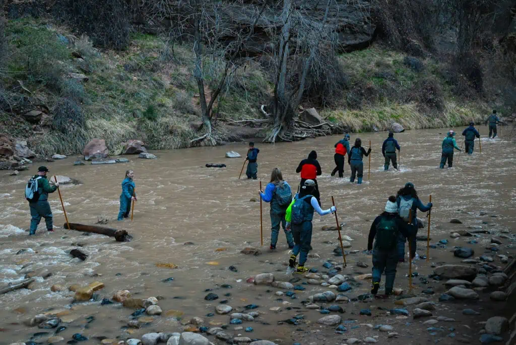
The Narrows (shuttle stop #9 – Temple of Sinawava)
A river hike through the narrowest section of Zion Canyon, with towering walls rising on either side. Hiking The Narrows requires specialized gear: typically neoprene socks, canyoneering shoes, and a walking stick, which can be rented at local outfitters in Springdale. Water levels and currents vary seasonally, and sections of the trail are closed during spring runoff or after heavy rain in monsoon season for safety. This hike offers one of the park’s most iconic and popular experiences, but does require preparation and caution.


Which Hike Is For you?
Easiest Trails with Little Elevation Gain
The Grotto
Pa’rus
Riverside Walk
Short Hikes with Big Rewards
The Watchman Trail
The Canyon Overlook Trail
Customizable Routes
You can mix and match any of the following trails to create full or partial loops. You don’t necessarily need to return to your starting point when visiting during shuttle season, with stops positioned along most trailheads (shuttle stops #4 Court of the Patriarchs, #5 Zion Lodge and #6 The Grotto).
The Grotto Trail
Kayenta Trail
Emerald Pools Trail
Sand Bench Trail
Best Overall Hikes (Views + Challenge)
West Rim Trail
East Mesa Trail
Zion’s Most Iconic Viewpoints
In our opinion, there are four truly iconic viewpoints in Zion, all of which require a hike to reach. Each offers a different perspective on the park’s scale, geology, and canyon depth, ranging from rim-top overlooks to exposed mid-canyon perches.
Observation Point
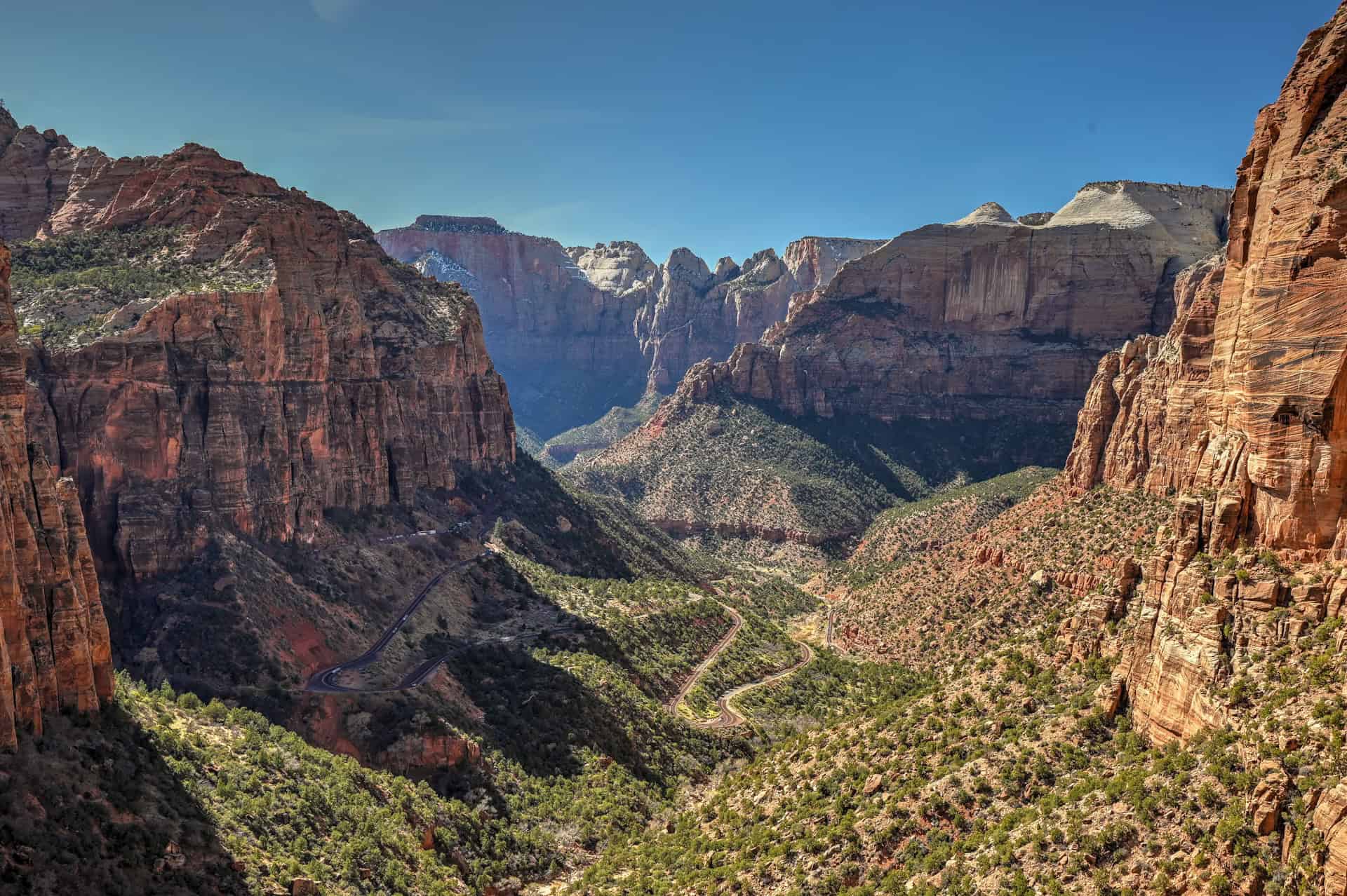
The highest accessible viewpoint overlooking Zion Canyon, offering a sweeping, top-down perspective of the entire main canyon. From here, Angels Landing appears far below, emphasizing the immense depth and vertical relief of the landscape.
West Rim Trail Switchbacks & Angels Landing
This section of the West Rim Trail delivers classic Zion views at multiple elevations as the trail climbs above the canyon floor. Whether from the long switchbacks or the narrow spine of Angels Landing, the perspective down into Zion Canyon is dramatic and constantly changing.
Canyon Overlook
A compact hike with an outsized payoff, Canyon Overlook looks down into Pine Creek Canyon and across the lower reaches of Zion Canyon. Its position near the east entrance makes it one of the easiest ways to reach a high, exposed viewpoint.
Scout Lookout
Perched high above the canyon floor, Scout Lookout offers one of the best accessible views without committing to the exposed final section of Angels Landing. It’s a natural stopping point with wide-open views in multiple directions and a strong sense of height.
Bonus Viewpoint: Big Bend
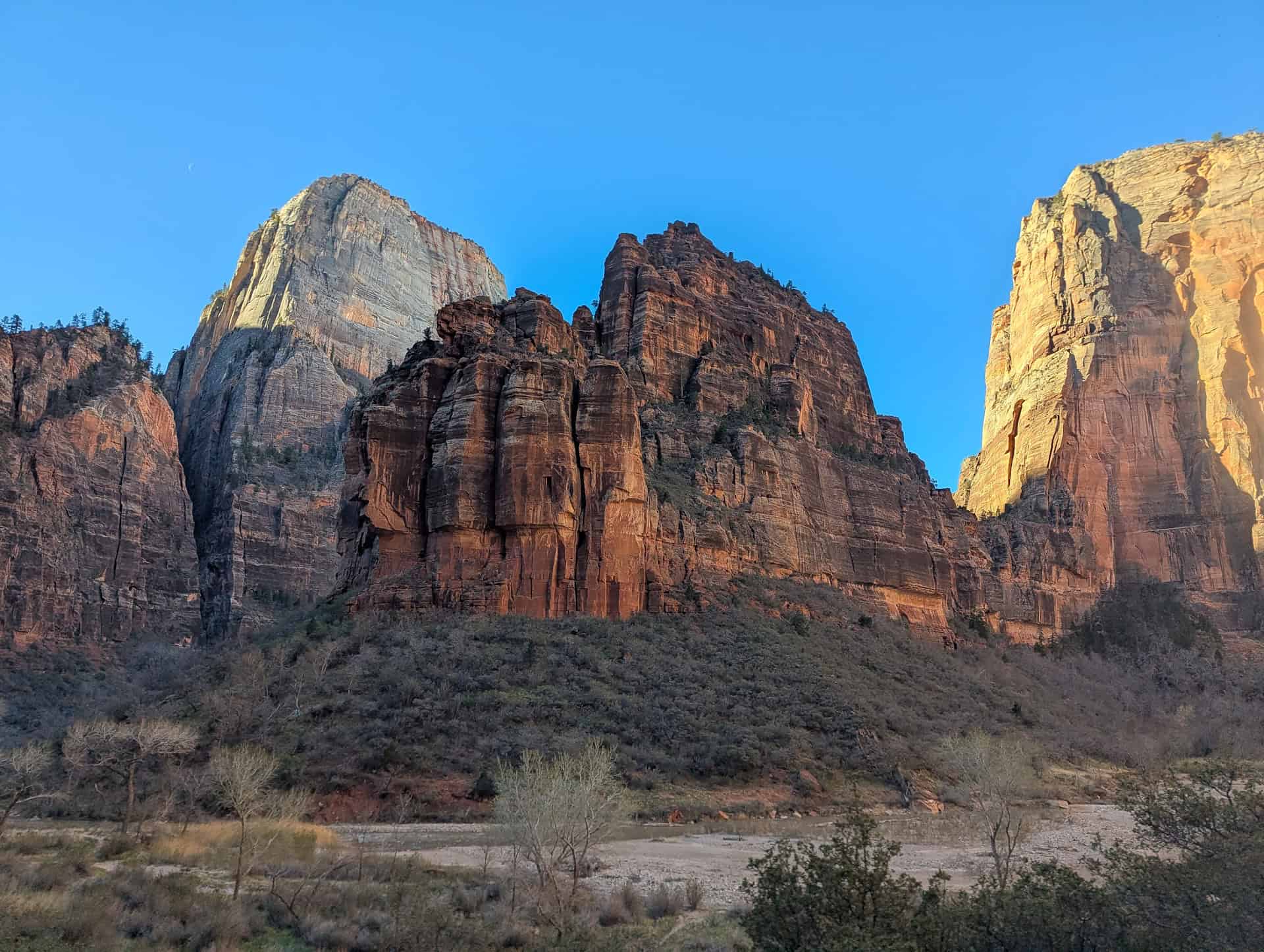
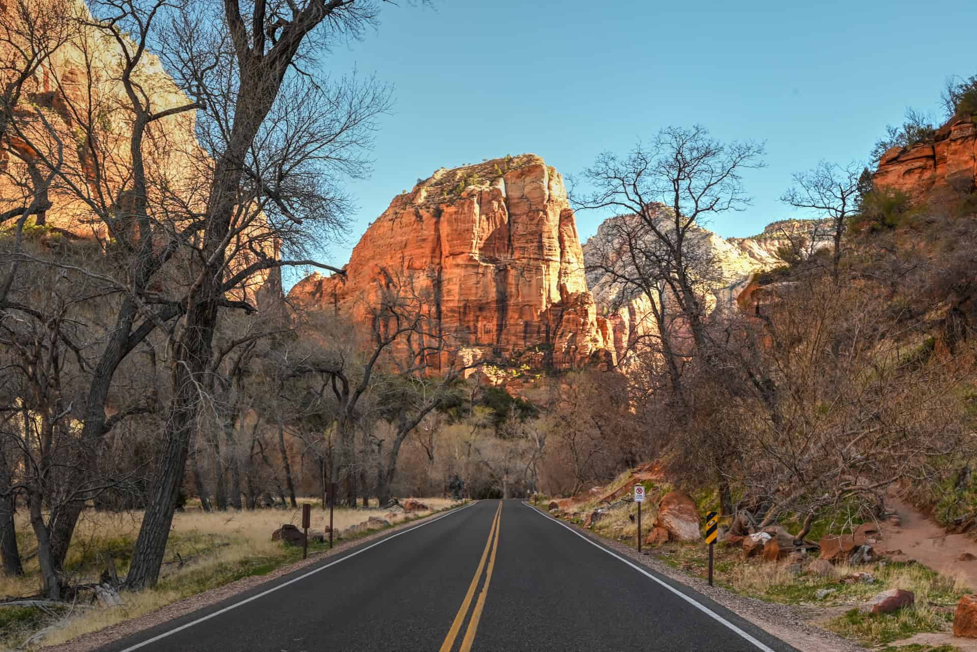
The only iconic viewpoint that doesn’t require a hike, Big Bend sits directly along the Zion Canyon Scenic Drive. From here, the canyon walls close in dramatically, creating one of the most recognizable roadside views in the park.
Other Zion Activities
While hiking is the main draw, Zion offers a few other ways to experience the park, particularly along the canyon floor and in its quieter corners.
Horseback Riding
Guided horseback rides operate seasonally in Zion Canyon and nearby areas, offering a slower-paced way to explore the landscape. Routes typically follow established trails and canyon-bottom paths, making this a good option for visitors who want scenery without long hikes. Several operators offer guided excursions, including East Zion Adventures and this GetYourGuide tour:
Cycling
Bicycles are permitted on the Pa’rus Trail and along park roads, including Zion Canyon Scenic Drive. Riding through the main canyon can be especially enjoyable when the shuttle is operating, as cyclists are allowed to share the road with shuttle buses. Bike rental shops are available all over Springdale. You might also be interested in a guided e-bike tour such as this one:
Canyoneering
Zion is a popular destination for technical canyoneering, with routes that involve rappelling, route-finding, and navigating narrow slot canyons. These trips require specialized equipment, experience, and, in many cases, permits. For more information, see the canyoneering activities offered by East Zion Adventures.
Riverside Walks and Nature Strolls
For those looking for something low-effort, Zion’s canyon floor offers several short walks along the Virgin River, including Riverside Walk and the Grotto. These provide close-up views of the canyon walls and river environment without committing to a full hike. The Pa’rus trail also allows for an easy walk along the park’s more open canyon section.
Kolob Canyons: The Other Zion
Kolob Canyons lies in the northwest corner of Zion National Park and is completely separate from the main canyon area near Springdale. Accessed directly from Interstate 15, it sits roughly 45 minutes to an hour from Zion Canyon, depending on traffic, and feels far removed from the park’s busiest corridors.
We didn’t get to visit Kolob Canyons during our time in Zion, but it’s generally seen as a quieter alternative to the main canyon and is defined by deep red rock canyons and long, finger-like ridges.
Within the Kolob Canyons, a short scenic drive leads to several viewpoints and trailheads, including the Taylor Creek and Timber Creek Overlook trails. While Kolob Canyons lacks the concentration of iconic hikes found in Zion Canyon, it can be a worthwhile addition for visitors with extra time or for those passing through southern Utah.
How Long Do You Need in Zion?
Zion is not a park that lends itself well to a rushed visit. While it’s possible to see a few highlights in a single day, the park’s layout, shuttle system, and elevation changes mean that most visitors benefit from slowing down and spreading activities across multiple days.
1–2 days:
With one or two days, you’ll likely focus on the main canyon and its most accessible or your must-see trails. It’s a good introduction, but you’ll miss many of Zion’s higher viewpoints and quieter areas.
3–4 days (ideal for most visitors):
Three to four days allows you to experience Zion at a more balanced pace. You can combine a longer, more demanding hike, such as the West Rim Trail, with shorter canyon-floor walks, while still leaving time and flexibility around weather or crowds. This timeframe also makes it easier to visit both the main canyon and the east side of the park without feeling rushed.
5 days or more:
With five or more days, you can explore beyond the main canyon, revisit favorite areas at different times of day, or add less-traveled trails and activities. This amount of time suits those interested in longer trails or those looking to include Kolob Canyons in their plans.
For most, 3–4 days offers the best balance, providing enough time to tackle Zion’s best hikes while still allowing for a relaxed, flexible visit.
The suggested itineraries below show a few practical ways to structure that time.
Zion Suggested Itinerary (3–4 Days)
This itinerary is designed for travelers spending three to four days in Zion, with a mix of longer hikes, shorter walks, and some flexibility built in. Arrival and departure days are kept lighter, while the more demanding hikes are spaced out to avoid stacking hard days back to back.
Arrival Day (from the west or east)
If you’re arriving from the west and reach the area early enough, a stop at Grafton Ghost Town makes for an easy and worthwhile detour before entering the park. From there, the Watchman Trail is a good first hike: it’s close to the south entrance, straightforward, and not dependent on the shuttle system.
If you’re arriving from the east, start with the Canyon Overlook Trail, which sits right along the Zion–Mount Carmel Highway and works well as a quick introduction to the park. If time and energy allow, you can add the Watchman Trail later in the day.
Day 2: Zion Canyon Core Hikes
Spend your second day in the main canyon using the shuttle system. Start early with the West Rim Trail, hiking to Scout Lookout or continuing onto Angels Landing if you have a permit. After a break, spend the remainder of the day exploring the trails around Emerald Pools, using a combination of the Emerald Pools Trail, Kayenta Trail, and Grotto Trail to build a loop that matches your energy level.
Day 3: East Side Views and a Recovery Walk
Begin the day with the East Mesa Trail to Observation Point, one of the best viewpoints in the park, with relatively moderate effort. If you still have energy in the afternoon, add a short, low-impact walk such as Riverside Walk (to see the start of The Narrows) or the Pa’rus Trail, both of which are easy ways to experience the canyon without another big climb.
Day 4 (Departure Day)
Use your final day to fill in anything you missed or want to revisit. This might be a short hike like the Watchman Trail if you skipped it earlier, or simply a relaxed walk along the river. If you’re heading east, Canyon Overlook makes a convenient final stop; if you’re departing to the west, consider visiting Grafton Ghost Town if you didn’t on arrival.
If you’d prefer to avoid some of the more strenuous hikes, several days in this itinerary can be adapted by replacing longer trails with an e-bike ride through Zion Canyon or a guided horseback ride, both of which offer a different way to experience the park without the elevation gain.
Best Time to Visit Zion National Park
Zion is a year-round destination, but the experience can vary dramatically depending on the season. Weather, crowd levels, shuttle operations, and trail conditions all play a major role in what you’ll be able to do and how busy the park will feel.
Spring (March–May)
Spring is one of the most popular times to visit Zion, thanks to mild temperatures and blooming desert vegetation. Daytime highs are generally comfortable for hiking, though mornings and evenings can still be cool, especially in March.
Crowds increase quickly as spring progresses, and by March, the Zion Canyon shuttle is typically in operation, meaning private vehicles are not allowed in the main canyon. Snowmelt often leads to high water levels in the Virgin River, which can result in temporary closures of The Narrows, sometimes well into late spring.
Overall, spring is an excellent time for canyon hikes like the West Rim and Observation Point, but expect busy trails and plan on early starts.
Summer (June–August)
Summer brings the hottest temperatures and the highest visitation, especially in Zion Canyon, where midday heat and packed shuttle buses are common. Afternoon temperatures frequently exceed 90°F (32°C), and exposed hikes can feel especially strenuous.
The shuttle system is in full operation, and parking in Springdale fills early. Monsoon season, typically from mid-summer into early fall, can trigger sudden thunderstorms and flash flooding, leading to short-notice trail closures, particularly in The Narrows and other narrow drainages.
That said, summer does offer long daylight hours and reliable access to high-elevation trails. Early morning hikes and shaded canyon walks become essential for a more comfortable experience.
Fall (September–November)
Fall is widely considered the best time to visit Zion. Temperatures cool, crowds begin to thin after early September, and hiking conditions are generally excellent. Fall colors add extra appeal, especially along the river and in higher-elevation areas.
The shuttle system usually continues operating through much of the fall, but lines are shorter and parking in town is easier than in summer. Water levels in the Virgin River typically drop, increasing the likelihood that The Narrows will be open.
By late October and November, days become shorter and cooler, and some higher trails may see early snow, but overall fall offers one of the most balanced Zion experiences.
Winter (December–February)
Winter is the quietest season in Zion and can be a surprisingly rewarding time to visit. Snow occasionally dusts the canyon walls, creating dramatic scenery, and crowds are significantly lighter than the rest of the year.
The shuttle system is usually not in operation, allowing private vehicles to drive through Zion Canyon—one of the few times of year this is possible. However, winter conditions can lead to icy trails, temporary road closures (including the Zion–Mount Carmel Highway during storms), and limited access to higher elevations.
Most hiking is still possible at lower elevations with proper footwear, but The Narrows is typically closed due to cold water and safety concerns.
Quick Summary: When to Visit Zion
- Spring and fall offer the best overall experience, with comfortable hiking temperatures, reliable trail access, and (in fall especially) more manageable crowds.
- Summer and early fall are generally the best times to hike The Narrows, when water levels are lower, and conditions are more likely to be safe; though heat, crowds, and afternoon storms are factors to watch.
- Winter is ideal if you’re looking for a quieter visit and the rare chance to drive your own vehicle through Zion Canyon, though some trails and roads may be icy or temporarily closed.
What Else to See and Do Near Zion National Park
If you’re continuing your Utah road trip beyond Zion, there are several worthwhile stops within easy driving distance. Depending on which direction you’re heading, these make natural additions before or after your time in the park.
If You’re Heading West
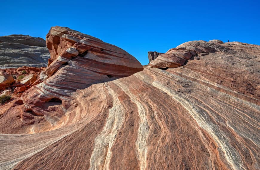
Valley of Fire State Park
Located about 2.5 hours southwest of Zion, Valley of Fire is Nevada’s oldest state park and a striking contrast to Zion’s towering canyon walls. Its vivid red sandstone formations, short hikes, and easily accessible viewpoints make it a rewarding stop for travellers heading toward Las Vegas. The park is well-suited to a half-day or full-day visit, especially if you’re already planning a desert-focused road trip.


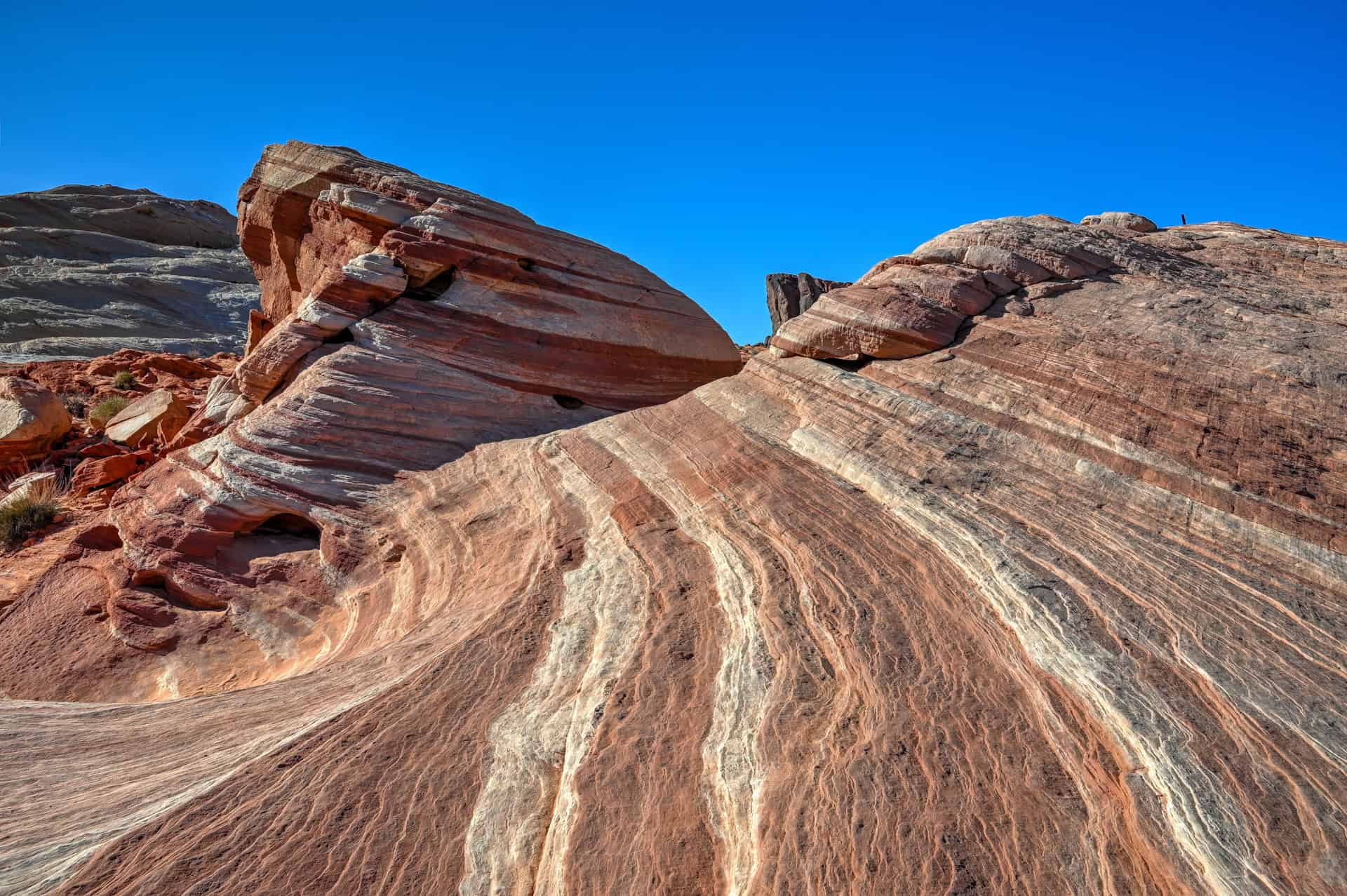
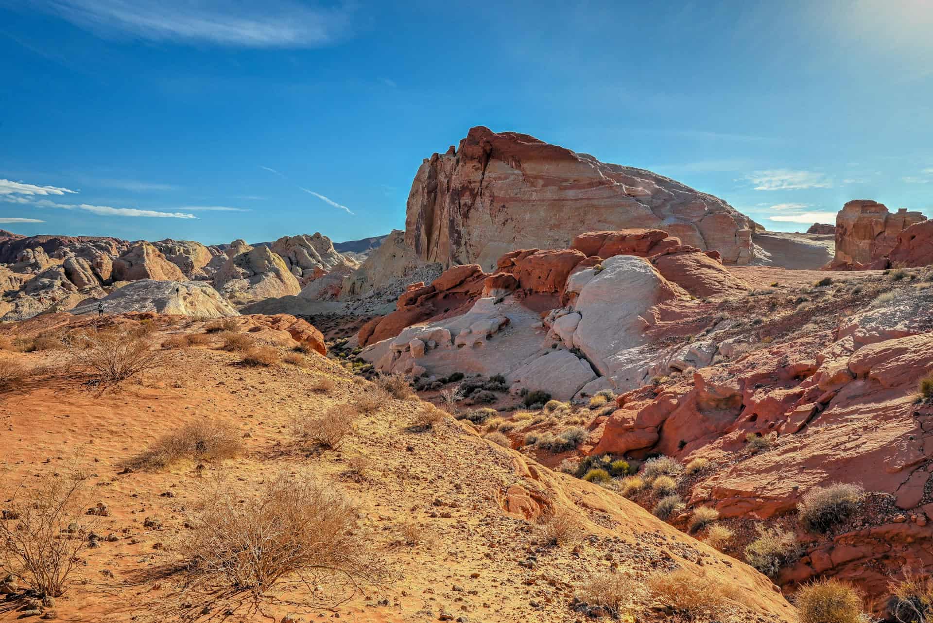
For more information and planning tips, see our detailed visiting guide for Valley of Fire State Park.
Snow Canyon State Park
Just outside St. George, Snow Canyon is often overlooked by visitors rushing to Zion, but it’s well worth a stop. The park features red and white sandstone cliffs, lava flows, petrified dunes, and a network of short, scenic trails. It’s quieter and more compact than Zion, making it a good option for a relaxed morning or afternoon hike without dealing with shuttle logistics or crowds.


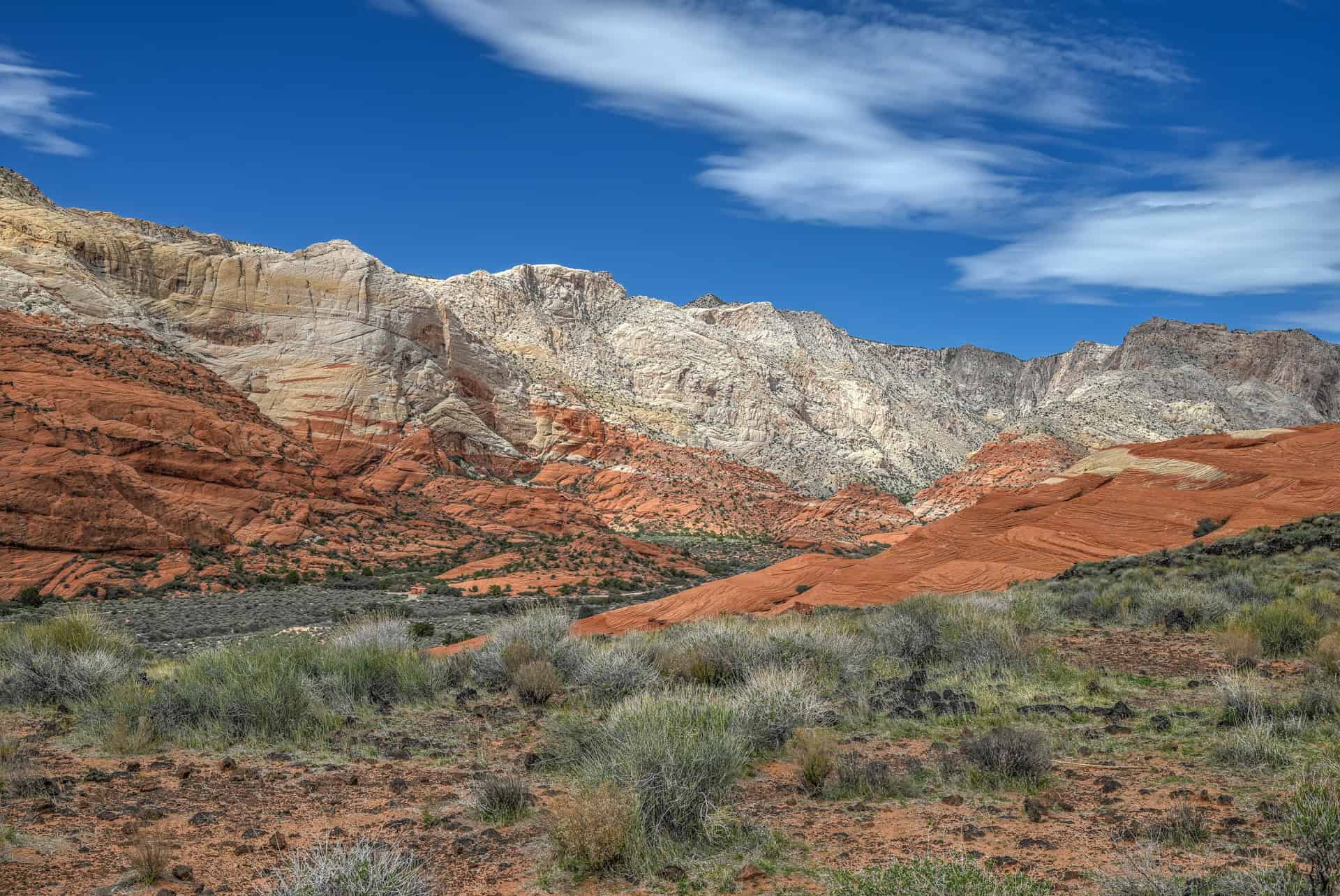
For more information and travel planning tips, see our detailed visiting guide for Snow Canyon State Park.
Grafton Ghost Town
Grafton Ghost Town offers a glimpse into Utah’s pioneer past. Founded in the mid-1800s, this small settlement once thrived despite harsh conditions, only to be gradually abandoned as families moved on to more accessible locations. Whether you’re drawn by history, scenery, or a touch of the eerie, Grafton makes for a memorable short excursion when travelling west of Zion.


For more information and travel planning tips, see our detailed visiting guide for Grafton Ghost Town.
If You’re Heading East
Kanab Sand Caves
A short drive east of Zion near the town of Kanab, the Kanab Sand Caves are an easy and popular roadside stop. A brief but steep trail leads to man-made caves carved into the sandstone, offering wide views over the surrounding desert. It’s a quick visit that pairs well with other eastern Utah or northern Arizona destinations.


Bryce Canyon National Park
About two hours northeast of Zion, Bryce Canyon is known for its dense concentration of hoodoos and amphitheater-style viewpoints. While very different in scale and terrain, it complements Zion well, especially if you’re continuing deeper into southern Utah. Bryce can be experienced largely from viewpoints or through short hikes descending into the hoodoo-filled basins.


For more details and visiting tips, see our Bryce Canyon National Park Guide.
Where to Stay Near Zion National Park
If you want to stay close to Zion without dealing with limited parking at the Visitor Center or juggling both the Springdale shuttle and the Zion Canyon shuttle, the northern end of Springdale is one of the most practical places to base yourself. Lodging here puts you within a short walk or drive of the park entrance, allowing you to start early and simplify logistics during peak season.
Below are two solid, well-located options that balance comfort, convenience, and access. Both are within a 20-minute walk of the park’s southern entrance.
Best Western Plus Zion Canyon Inn & Suites
What sets it apart: Reliable comfort and one of the closest hotel locations to the park entrance.
This modern Best Western sits at the quiet northern end of Springdale, within easy walking distance of Zion’s pedestrian entrance. Rooms are clean and spacious, and amenities include an outdoor pool, hot tub, and complimentary breakfast. Its location makes it especially appealing for hikers planning early starts, as you can avoid parking constraints and step straight into the shuttle system.
Cliffrose Springdale, Curio Collection by Hilton
What sets it apart: Riverside setting with resort-style grounds, right at the edge of the park.
Cliffrose is one of the closest properties to Zion’s entrance, offering direct access to the Virgin River and beautifully maintained gardens. While more polished than a standard mid-range hotel, it remains a practical choice thanks to its walkability, on-site amenities, and proximity to the park. It’s well-suited for travellers who want a comfortable base with a quieter, more relaxed atmosphere after long hiking days.
Booking Tip: Springdale accommodations fill quickly, particularly in spring and fall. Staying near the park entrance is especially valuable during shuttle season, so booking well in advance is strongly recommended.
Zion National Park – Frequently Asked Questions
Do you need a reservation to enter Zion National Park?
No reservations are required to enter Zion National Park itself. You can pay the entrance fee at the gate or use an America the Beautiful pass. However, some activities, such as hiking Angels Landing, do require advance permits.
Do I need to use the Zion shuttle?
During most of the year (typically March through November), private vehicles are not allowed on Zion Canyon Scenic Drive. During this period, the park shuttle is required to access trailheads in the main canyon. In winter, when the shuttle is not operating, private vehicles are usually permitted, weather and road conditions allowing.
Can you drive through Zion National Park?
Yes. The Zion–Mount Carmel Highway, which connects the park’s south and east entrances, is open year-round and accessible by private vehicle. This route includes the Zion–Mount Carmel Tunnel and provides access to Canyon Overlook and the park’s eastern section.
Is Angels Landing dangerous?
Angels Landing is exposed and can feel intimidating, especially for those uncomfortable with heights. Chains are installed along the narrowest sections, but there are steep drop-offs on both sides. Many hikers choose to stop at Scout Lookout, which offers excellent views without the exposure.
Do you need a permit to hike Angels Landing?
Yes. A permit obtained through a seasonal lottery system is required to hike the final section beyond Scout Lookout. No permit is needed for the West Rim Trail up to Scout Lookout.
Is Zion suitable for beginners or families?
Yes. While Zion has some strenuous and exposed hikes, it also offers easy, mostly flat trails such as the Pa’rus Trail, the Grotto Trail, the Lower Emerald Pools Trail, and the Riverside Walk. These are well-suited to beginners and anyone looking for a more relaxed experience.
Can you hike The Narrows year-round?
The Narrows is typically accessible late spring through early fall, depending on water levels and weather. High water from snowmelt or monsoon storms can lead to temporary closures. Even when open, proper footwear and, in colder months, specialized gear are recommended.
Where can you rent gear for The Narrows?
Outfitters in Springdale rent water shoes, neoprene socks, dry pants, and walking sticks specifically designed for The Narrows. Renting locally allows you to adjust gear choices based on current conditions.
Is Zion worth visiting in winter?
Yes, especially if you prefer fewer crowds. Winter offers quieter trails, cooler hiking conditions, and the rare opportunity to drive through Zion Canyon. Some trails may be icy or temporarily closed, so flexibility is important.
How crowded does Zion get?
Zion is one of the most visited national parks in the U.S. Crowds are heaviest in spring and summer, particularly in Zion Canyon. Early starts, visiting in the shoulder seasons, or focusing on less-trafficked areas like the East Mesa can make a big difference.
Explore More Utah National & State Park Guides
Continue exploring Utah with these detailed guides:
Bryce Canyon National Park Guide
Capitol Reef National Park Guide
Snow Canyon State Park Guide
Valley of Fire State Park Guide
Goblin Valley State Park Guide
Photography Gear
If you like our photography, you might be interested in some of the gear we use to shoot our travel and hiking destinations.
Camera Body – Nikon Z 6ii Fx-series Mirrorless Body
Main Lens – NIKON 24-120mm F/4G ED VR AF-S
Zoom Lens – Sigma 745-306 150-600mm f/5-6.3
Polarizing filters – Urth Circular Polarizing (CPL)
Camera Tripod – K&F Concept 64-inch Camera Tripod
Mini-tripod – Lammcou Flexible Camera Tripod
Camera/hiking backpack – Vanguard Alta Rise 48 Backpack
Universal Travel Adapter – VYLEE Universal International Power Travel Plug
Other Travel Essentials
Travel Insurance
SafetyWing is a travel insurance company that offers comprehensive coverage for travellers. Includes Medical Insurance and Travel Insurance. Primarily geared towards long-term travellers, digital nomads, and expats.
e-Sim cards
Airalo is the world’s first and largest eSIM store with eSIM plans for 200+ countries and regions worldwide. With Airalo eSIMs, travellers can get connected the moment they land at their destination and avoid nasty data roaming charges
eSIMS are a sustainable alternative to single-use SIM cards – they are 100% digital, require less energy to produce and be re-used rather than disposed of.
Car Rentals
Discover Cars is our go-to website for car rentals. We almost always find our preferred rate there.
Transfer from Airport
Welcome Pickups is our favourite private transfer service, which you can pre-book at a fixed price. Currently available in 220 cities all over the world (mostly in Europe, but with several major cities in Asia, the Middle East and the US).
Kiwitaxi is another private transfer service – we haven’t tried it yet, but it’s currently available in a few more countries (102 as of 2024).
Hotels and Accommodations (coming soon)
Photography Prints
If you found this blog useful, you can help support our blog by purchasing low-cost digital prints. Printed physical prints are also available for purchase.


—–
Well, that wraps it up! We hope you enjoyed our Zion National Park Guide and that it will prove useful for planning your trip.
—–
You might also be interested in these related pages: