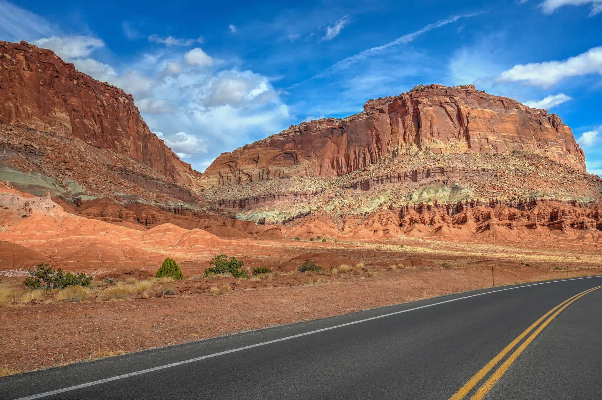
If you only have a day to spend in Capitol Reef National Park, you can still experience much of what makes this Utah gem so special: towering red cliffs, hidden canyons, ancient petroglyphs, and the quiet charm of the historic Fruita settlement. Unlike some of Utah’s larger national parks, Capitol Reef’s most scenic attractions are concentrated within a short stretch along Highway 24 and the park’s Scenic Drive, making it easy to explore even with limited time. In this guide, we’ll show you how to make the most of a single day in Capitol Reef, whether you’re passing through on a road trip between Bryce Canyon and Moab, or simply looking to sample the park’s unique blend of geology, history, and desert beauty.
Capitol Reef One-Day Highlights – At a Glance
Two iconic hikes – Stretch your legs on the short, family-friendly Hickman Bridge Trail, leading to a massive sandstone arch, and the easy Grand Wash Trail, a slot-like canyon walk with sheer cliffs rising 500 feet above you.
Historic Fruita charm – Wander past the classic Fruita Barn, a symbol of the park, and stop at Gifford Homestead for homemade pies, jams, and a taste of pioneer history.
Scenic viewpoints – Soak up sweeping vistas at Panorama Point and marvel at the dramatic Fluted Wall, where Capitol Reef’s layered geology is on full display.
Convenient trailhead access – Begin right from the dedicated parking areas on Highway 24, making this one of the park’s most accessible adventures.
Roadside beauty – Drive Highway 24 through the heart of the park and add the paved Scenic Drive Road for easy access to trailheads and stunning canyon views.


Disclosure: This page (Capitol Reef National Park – Best Hikes and One-Day Itinerary) may contain product affiliate links. At no additional cost to you, we may receive a commission for purchases made through these links. More details can be found on our disclosure and policies page.
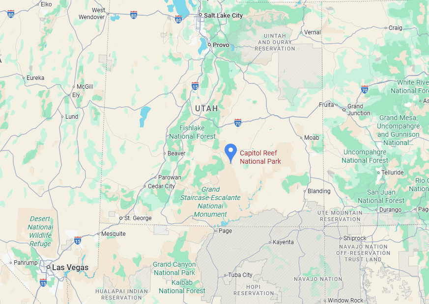
Capitol Reef National Park Location, Map, and How to Get There
Capitol Reef National Park sits in south-central Utah (link to Google Maps), right in the heart of red rock country. It’s often called the “hidden gem” of Utah’s Mighty 5, less crowded than Zion, Bryce, Arches, or Canyonlands, yet conveniently located between Bryce Canyon and Arches/Moab, making it a natural stop on a classic Utah road trip, particularly on your way to or from Bryce Canyon.
The simplest way to reach Capitol Reef is by driving there, as public transportation to the National Park is very limited.
Driving times to Capitol Reef National Park (Fruita area)
- Salt Lake City, UT: 350 km / 220 mi – about 3.5–4 hours
- Moab, UT: 240 km / 150 mi – about 2.5–3 hours
- Bryce Canyon City, UT: 190 km / 120 mi – about 2.5 hours
- Page, AZ (Lake Powell): 420 km / 260 mi – about 4.5-5 hours
- Las Vegas, NV: 540 km / 335 mi – about 5–5.5 hours
- St. George, UT: 350 km / 220 mi – about 3.5–4 hours
These times assume good weather and minimal stops; add extra time for scenic byways such as Highway 12, which is slower but spectacular.
If you need to book a rental vehicle for your road trip, we highly recommend using Discover Cars to get the best rates on your rental in Utah, Nevada and Arizona.
We also highly recommend Airalo (eSIM card) for your connectivity needs when travelling abroad. Airalo is the world’s first and largest eSIM store with eSIM plans for 200+ countries and regions worldwide.
Nearest Gas Station
There are several gas stations west of Fruita in Torrey, about a 15-minute drive away. Heading east, the nearest gas station is in Hanksville, about a 45-minute drive away.
Capital Reef National Park Entry Fees
Anyone visiting Capitol Reef National Park, whether to hike, take a scenic drive, or simply enjoy the views, must pay the applicable entrance fee to the National Park Service.
Entrance Fees (per vehicle, valid 7 days)
Private vehicle: $20
Motorcycle: $15
Individual (on foot, bicycle, etc.): $10
Annual Pass Options
Capitol Reef Annual Pass: $35 – unlimited entry for one year from the month of purchase.
America the Beautiful Pass: $80 – valid for one year at all U.S. National Parks and more than 2,000 federal recreation sites nationwide.
As of 2025, passes can be purchased at the Visitor Center in Fruita (link to Google Maps), self-pay stations, or online through the USGS website or via the REI store.
Which Pass Should You Get?
Capitol Reef Annual Pass ($35): Best if you live nearby or plan to visit Capitol Reef multiple times within a year. It pays off after just two visits.
America the Beautiful Pass ($80): If your trip includes Capitol Reef plus at least two other national parks or monuments (for example, Arches, Canyonlands, Bryce Canyon, Zion, or even Grand Canyon), this is the clear winner. Many Utah road trips easily cover 3–5 parks, making this pass the best value by far.
7-Day Vehicle Pass ($20): The right choice if you’re only passing through Capitol Reef once and don’t plan on visiting any other U.S. national parks within a year.
—> Most visitors exploring Utah’s “Mighty 5” parks (Arches, Bryce Canyon, Canyonlands, Capitol Reef, and Zion) should strongly consider the America the Beautiful Pass—it saves money and avoids the hassle of buying separate entry fees at each park.
Opening Hours: Capitol Valley National Park is open year-round, 24 hours a day. However, the visitor center is typically open 8:00 a.m. to 4:30 p.m., with slightly reduced hours during the winter months.
Capitol Reef National Park – Some Quick Facts
Establishment: Capitol Reef was first designated as a national monument in 1937 by President Franklin D. Roosevelt and later upgraded to a national park in 1971.
Visitor Numbers: In 2024, the park welcomed around 1.4 million visitors, which ranks it in the middle tier of U.S. national parks, busier than remote parks like Great Basin, but far less crowded than Zion or Yellowstone.
Size: The park spans 241,904 acres (979 km²), stretching across south-central Utah’s canyon country, making it the 2nd largest park among Utah’s Mighty 5 (after Canyonlands).
Name Origins: “Capitol” refers to the white sandstone domes that resemble the U.S. Capitol building, while “Reef” is a nod to the barrier-like cliffs that made travel difficult, much like a coral reef at sea.
Archaeological Sites: Long before settlers, the Fremont Culture left behind petroglyphs, cliff dwellings, and irrigation systems that can still be seen along rock faces and near the Fremont River.
Unique Ranking: Among Utah’s “Mighty 5,” Capitol Reef is often considered the least visited, a fact many travellers see as an advantage, since trails and viewpoints feel less crowded.
Capitol Reef National Park – Why You Should Visit
Waterpocket Fold Wonder: Capitol Reef protects the Waterpocket Fold, a 100-mile-long wrinkle in the Earth’s crust that formed 50–70 million years ago. Towering cliffs, slot canyons, and natural bridges reveal colorful layers of sandstone, limestone, and shale that tell a geologic story spanning hundreds of millions of years.
Fruita’s Living History: At the heart of the park lies Fruita, a historic Mormon settlement where 19th-century orchards still bloom each spring. Visitors can pick ripe peaches, apples, and cherries in season, wander past preserved pioneer buildings, and stop at the classic Gifford Homestead for fresh pies and jams.
Dark Skies & Quiet Nights: Far from major cities, Capitol Reef is designated a Gold-Tier International Dark Sky Park, offering some of Utah’s clearest stargazing. The combination of high desert air and minimal light pollution makes the Milky Way blaze across the night sky.
Trails for Every Hiker: Despite its rugged appearance, the park offers hikes for all levels. From the easy Grand Wash and Hickman Bridge trails to longer adventures like Navajo Knobs or the multi-day Waterpocket Fold routes, you’ll find everything from slot canyons to sweeping mesa views.
Scenic Byways & Backways: Two spectacular drives showcase the park’s variety: the paved Scenic Drive (with side canyons like Capitol Gorge) and the adventurous Cathedral Valley Loop, a remote route where giant monoliths rise from a desert floor. Both reveal the vast, otherworldly beauty that defines Capitol Reef.
One-Day Itinerary Considerations
This one-day Capitol Reef itinerary is designed with road-trippers in mind, especially those travelling between Bryce Canyon and Moab as part of a larger Utah adventure. Capitol Reef covers nearly 242,000 acres, but much of its backcountry (like Cathedral Valley or the Temples of the Sun and Moon) lies in remote areas that require high-clearance 4WD vehicles and a serious time commitment. Those sites are spectacular but better suited for multi-day stays.
For a single day, the focus is on the Fruita area along Highway 24, where a surprising concentration of highlights is clustered close together. Here you’ll find orchards, historic sites, easy-to-access trails, and some of the park’s most dramatic geology, all without straying far from the main road. While you won’t see every corner of Capitol Reef, this route offers a varied and rewarding glimpse of what makes the park special, from natural arches to pioneer history to sweeping canyon views. It’s the perfect sampler of Capitol Reef for travellers short on time.
Itinerary Order
Since it’s only about a 10-minute drive between the easternmost and westernmost stops in this one-day itinerary, the order in which you visit them doesn’t really matter, as we’ll simply present them from east to west for convenience. That said, weather and season can shape your choice: on a hot summer day, for example, it makes sense to start early with the more exposed hikes like Hickman Bridge, then continue to Grand Wash, before finishing with the scenic drives, viewpoints, and a well-earned stop for homemade pie at Gifford Homestead.
The One-Day Capitol Reef Itinerary – Main Attractions
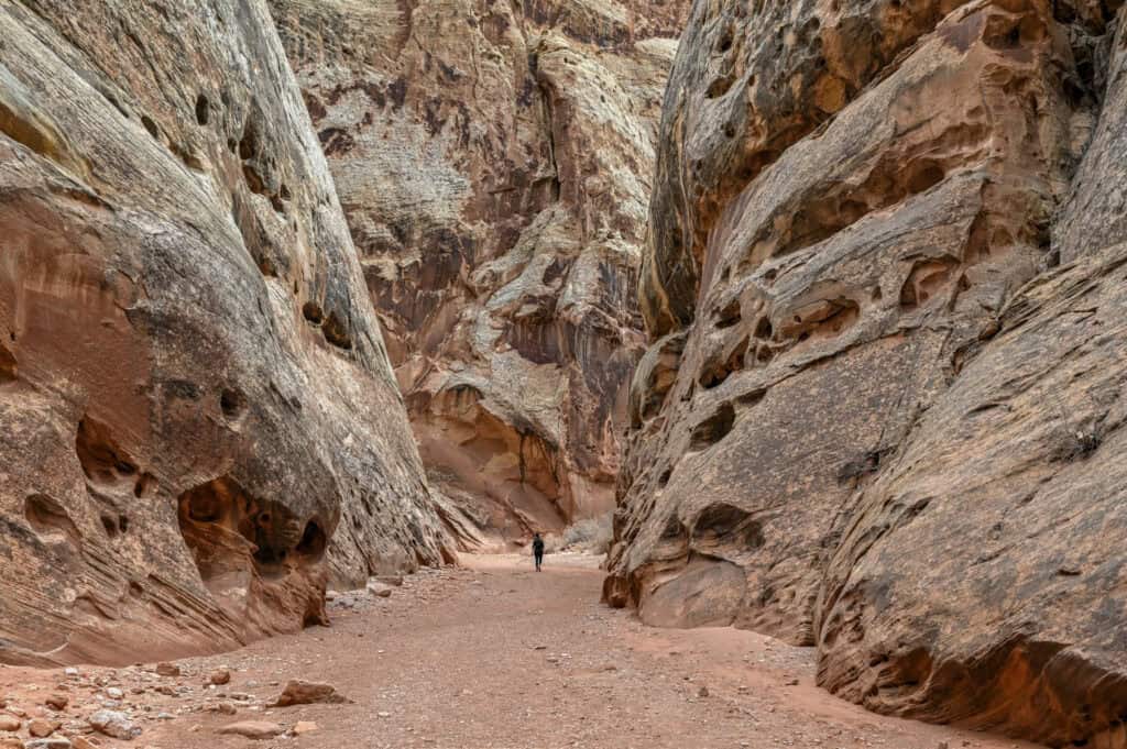
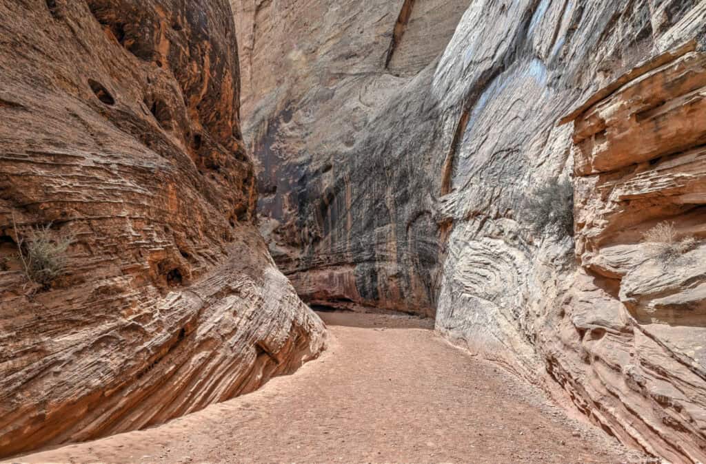
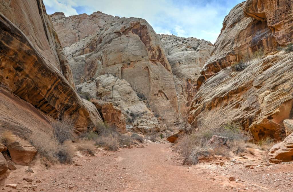
Grand Wash Trail
If you want to feel small in the best possible way, the Grand Wash Trail delivers. This 4.4-mile (7 km) out-and-back is mostly flat, making it one of the easiest ways to experience Capitol Reef’s towering Navajo sandstone walls up close. From the Highway 24 trailhead, the canyon begins wide and sunlit, with gravel flats and scattered vegetation, but gradually narrows as you continue deeper. In some places, the walls rise nearly 500 feet above you while closing to just 15 feet apart, creating a slot-canyon atmosphere without requiring any scrambling or technical skills. Along the way, look for honeycomb-weathered rock, streaks of black desert varnish, and striking patterns of light and shadow that change throughout the day. You don’t need to hike the entire trail to appreciate its beauty—even walking the first mile gives you a fantastic sense of scale and geology.


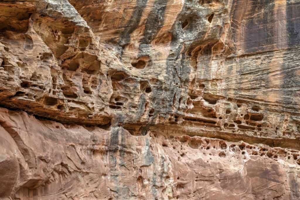
Time required: 1–2 hours, depending on how much of the trail you walk. Many visitors only do the first mile from the Highway 24 trailhead, which still takes you through the narrowest and most dramatic section of the canyon.
For more details about this hike, check out our Grand Wash Hiking Guide.
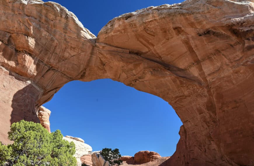
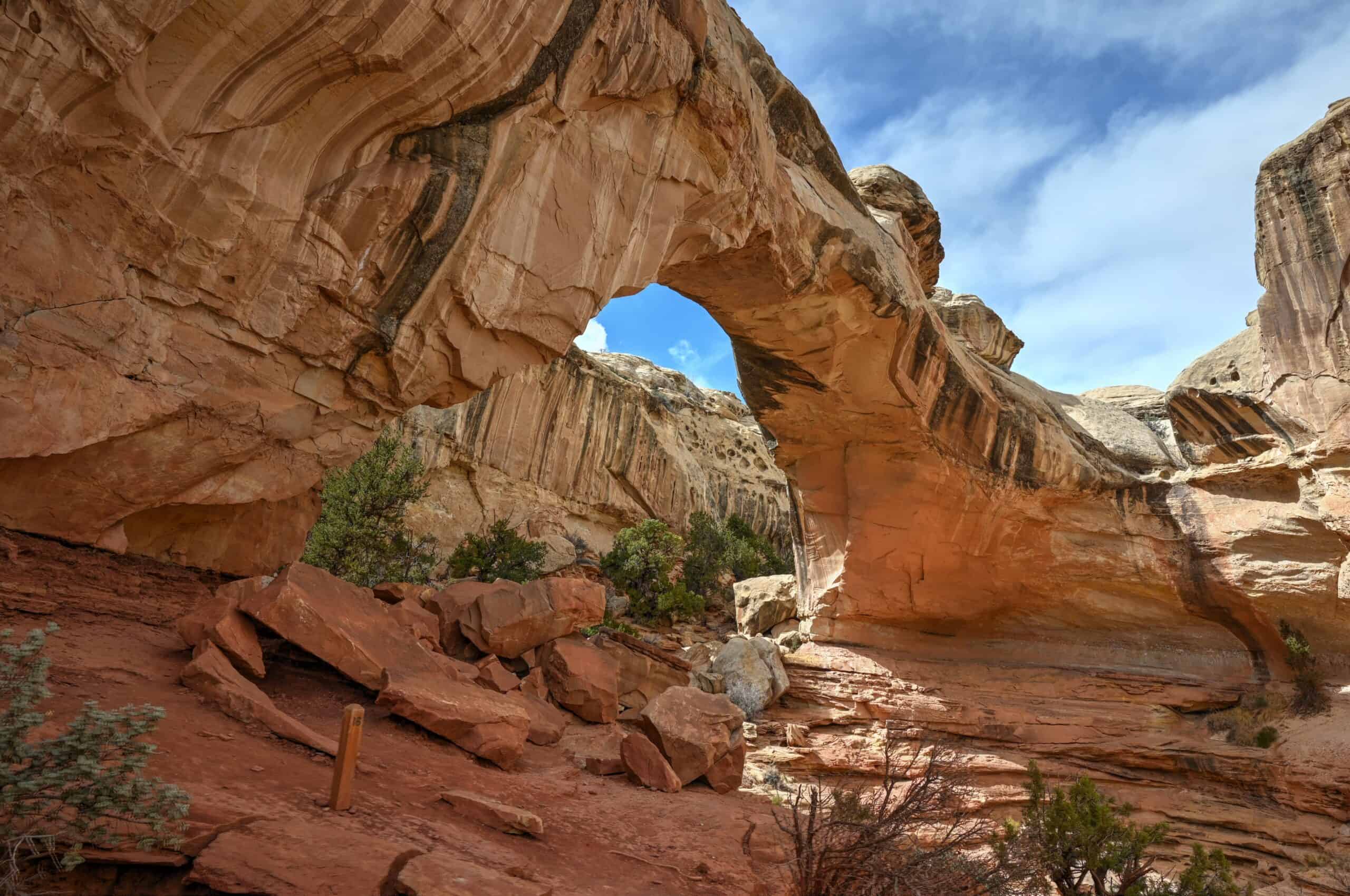
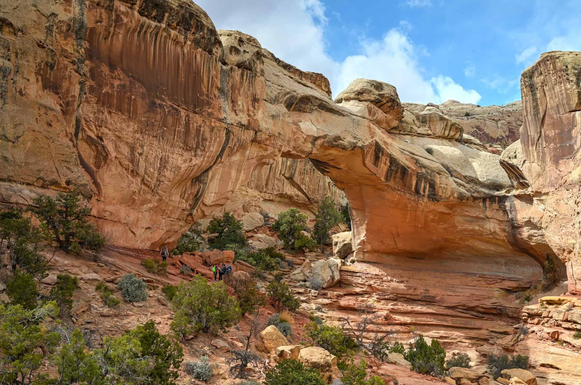
Hickman Bridge Trail
Short, accessible, and packed with scenery, the Hickman Bridge Trail is a must-do for first-time visitors. This 1.8-mile (2.9 km) round-trip trail starts relatively flat before climbing a series of stone staircases that quickly provide elevated views over the Fremont River canyon and Highway 24 below. After the initial climb, the path levels into a sandy wash where large trees and shrubs thrive, thanks to subsurface moisture retained between rains. A final spur loops up toward the main highlight, Hickman Bridge, a massive natural arch spanning 133 feet and rising 125 feet above the canyon floor. You’ll pass beneath the bridge itself before looping back along an exposed ledge, which offers some of the best views of the Waterpocket Fold and the surrounding red rock scenery. It’s a short hike with a big payoff, making it one of Capitol Reef’s most popular trails.


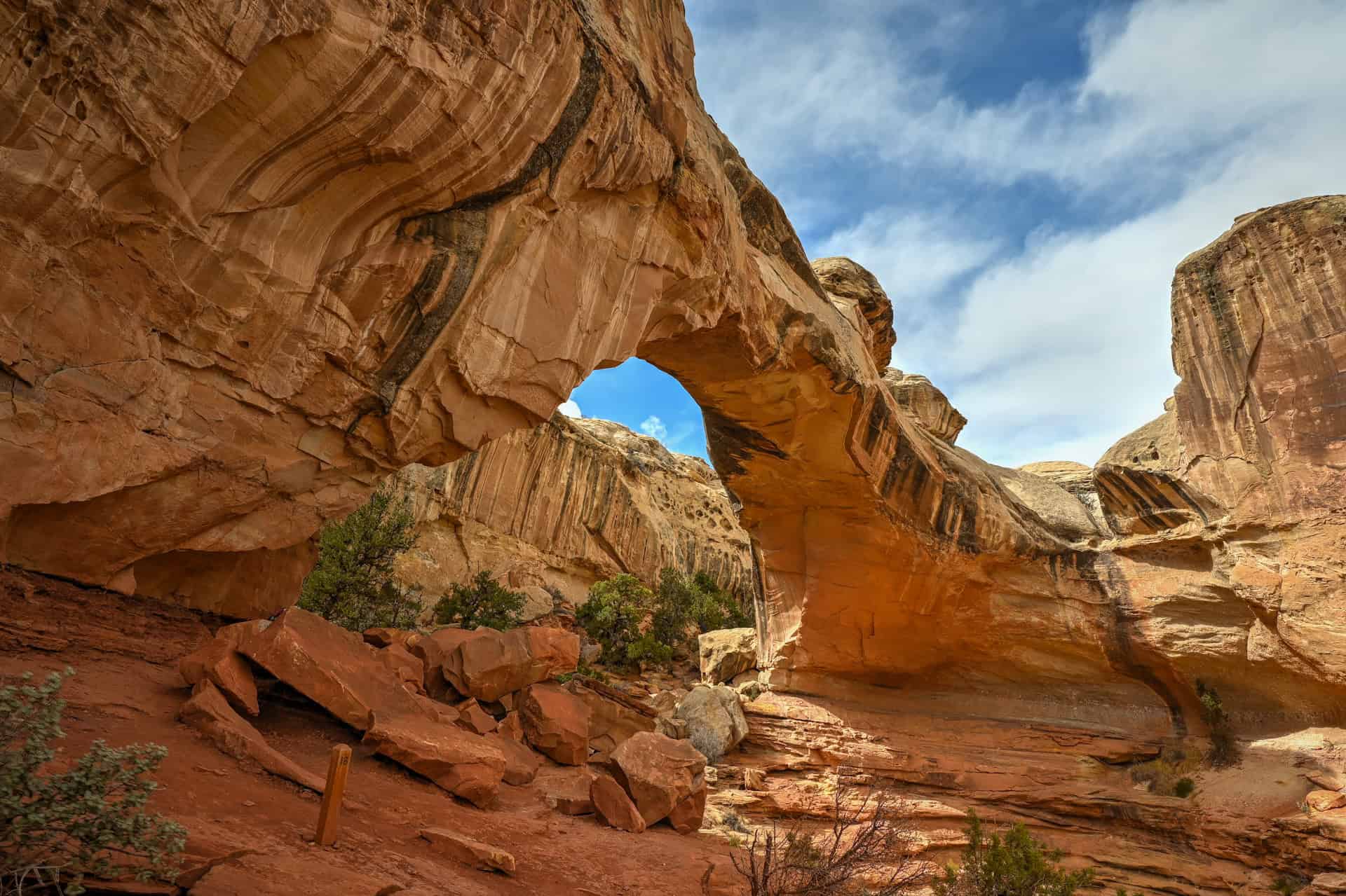
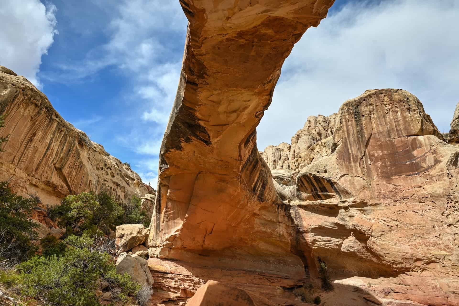
Time required: 1–1.25 hours round-trip at a moderate pace, with extra time if you linger at the arch or the viewpoints along the way.
For more details about this hike, check out our Hickman Bridge Hiking Guide.
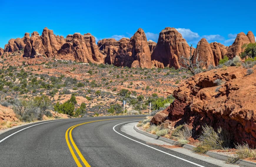
Scenic Drives
Driving through Capitol Reef is nearly as rewarding as hiking it, and both Highway 24 and the Scenic Drive Road deserve a spot on your itinerary. Highway 24 serves as the park’s main east–west corridor, cutting directly through its red-rock heart and connecting many of Capitol Reef’s best-known sites. Along this stretch, you’ll find access to trailheads for Hickman Bridge and Grand Wash, as well as several easy roadside stops like the Fremont petroglyph panels and a handful of panoramic viewpoints described further below. The section that passes through the national park spans about 16 miles and takes roughly 20 minutes to drive without stops.


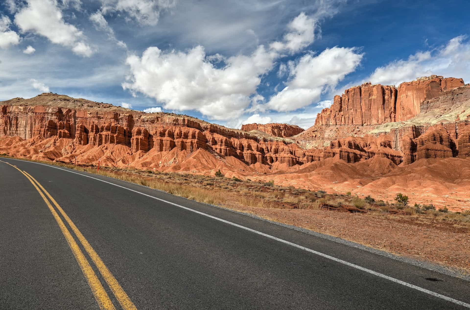
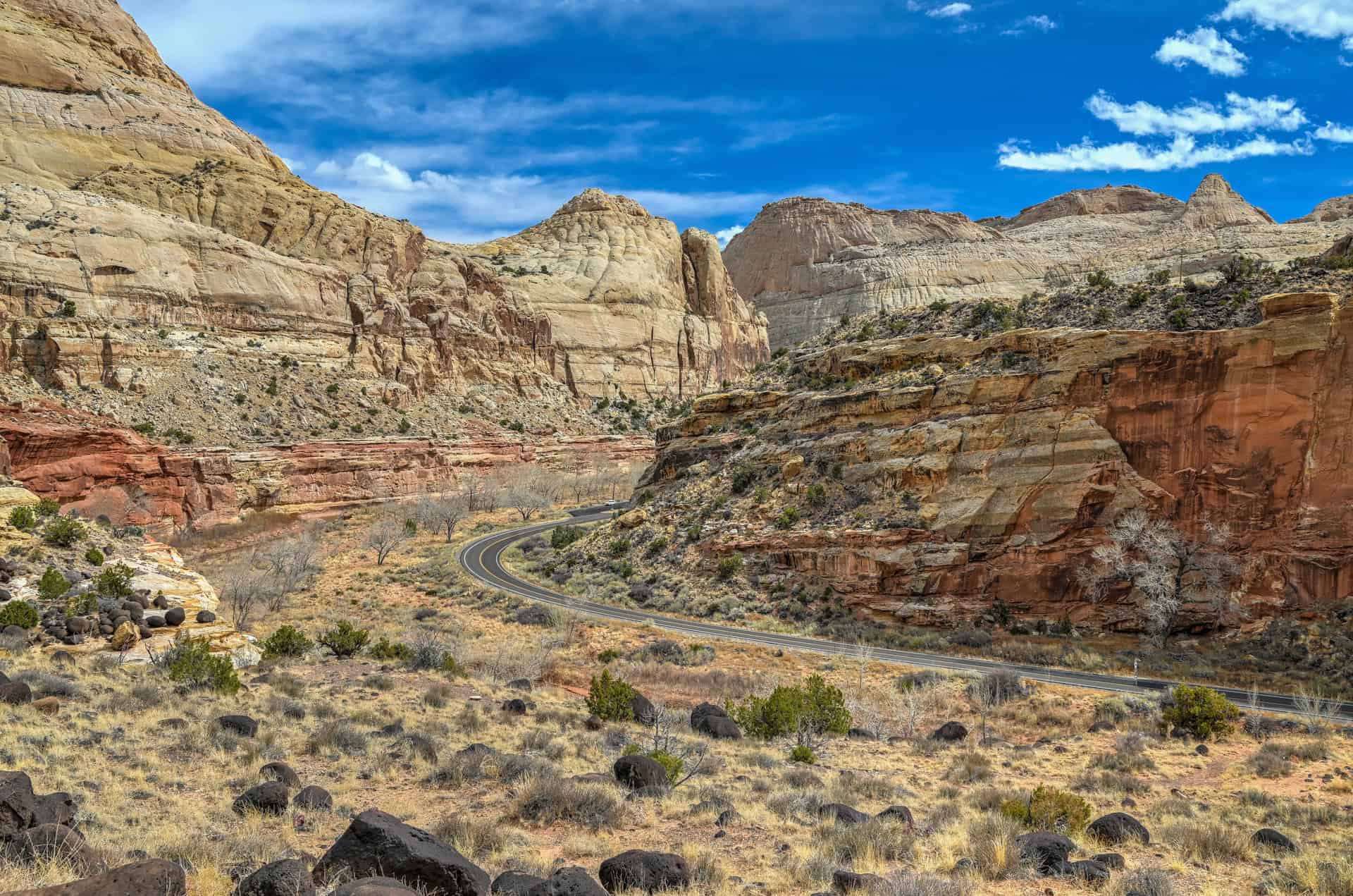
Branching south from Campground Road (which itself meets Highway 24), the Scenic Drive offers a deeper dive into the park’s geology (link to Google Maps). This paved 7.9-mile (12.7 km) route winds through the heart of the Waterpocket Fold, where sheer cliffs, sandstone domes, and colorful rock layers rise dramatically on either side. Expect the round-trip drive to take around 30 minutes without stops.
From the Scenic Drive, you can also explore two short unpaved spur roads: Grand Wash (link to Google Maps) and Capitol Gorge (link to Google Maps). These dirt routes lead to additional trailheads and viewpoints and are generally suitable for most passenger vehicles in dry conditions, though high clearance is recommended for rougher stretches or after heavy rains.
Time required: 1-1.5 hours if you drive both Highway 24 (through the park) and the full Scenic Drive Road, including a few scenic pullouts. Add another 30 minutes if you plan to continue down the unpaved Capitol Gorge Road.
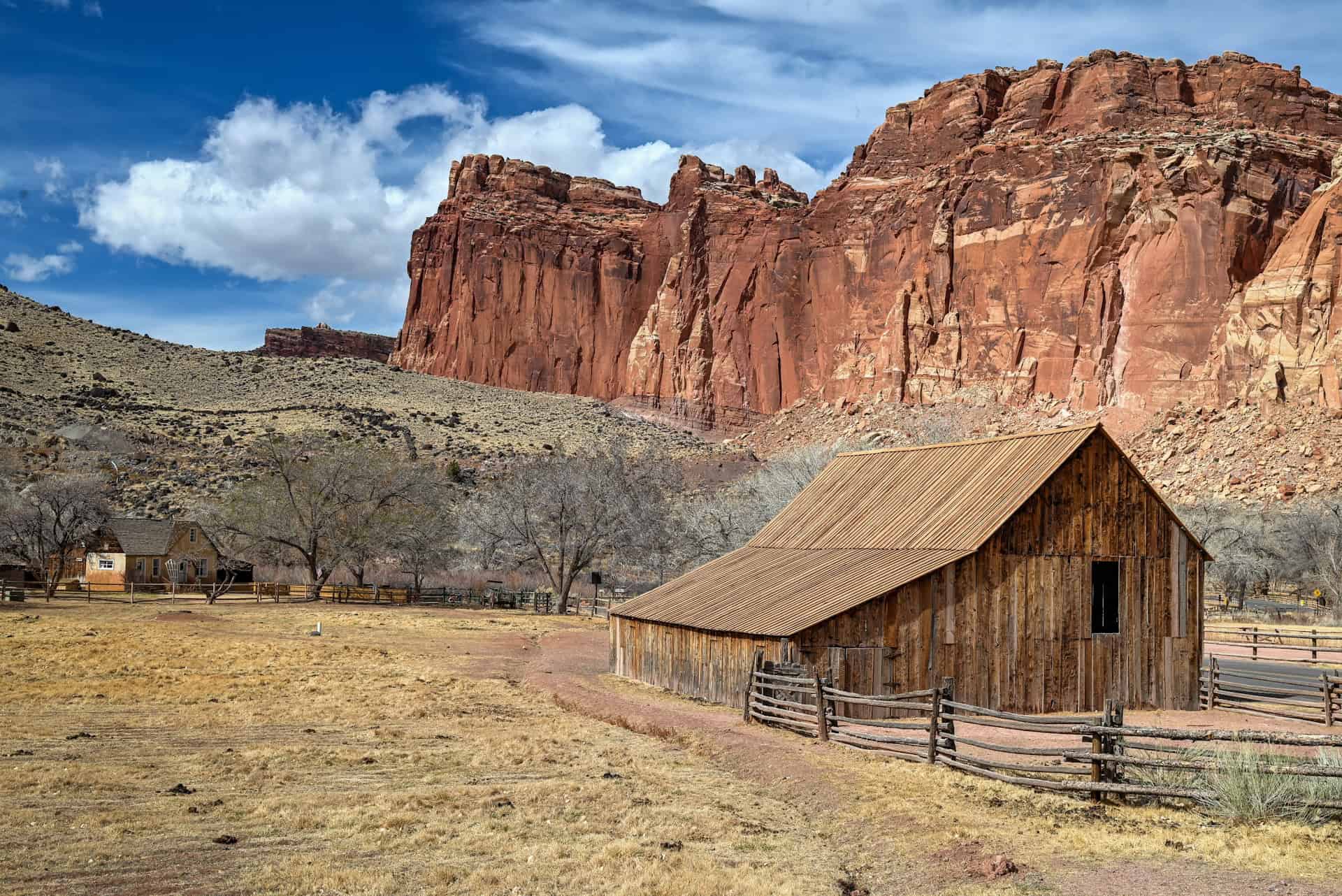
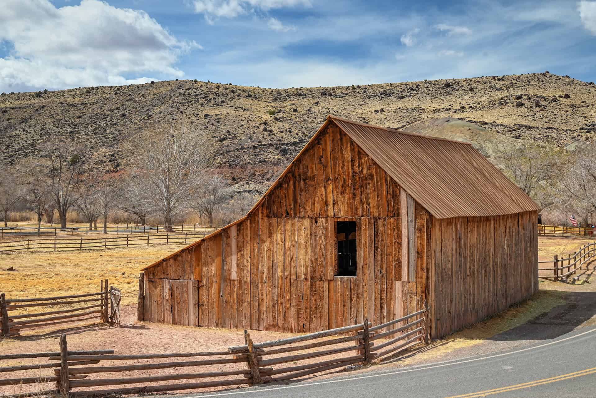
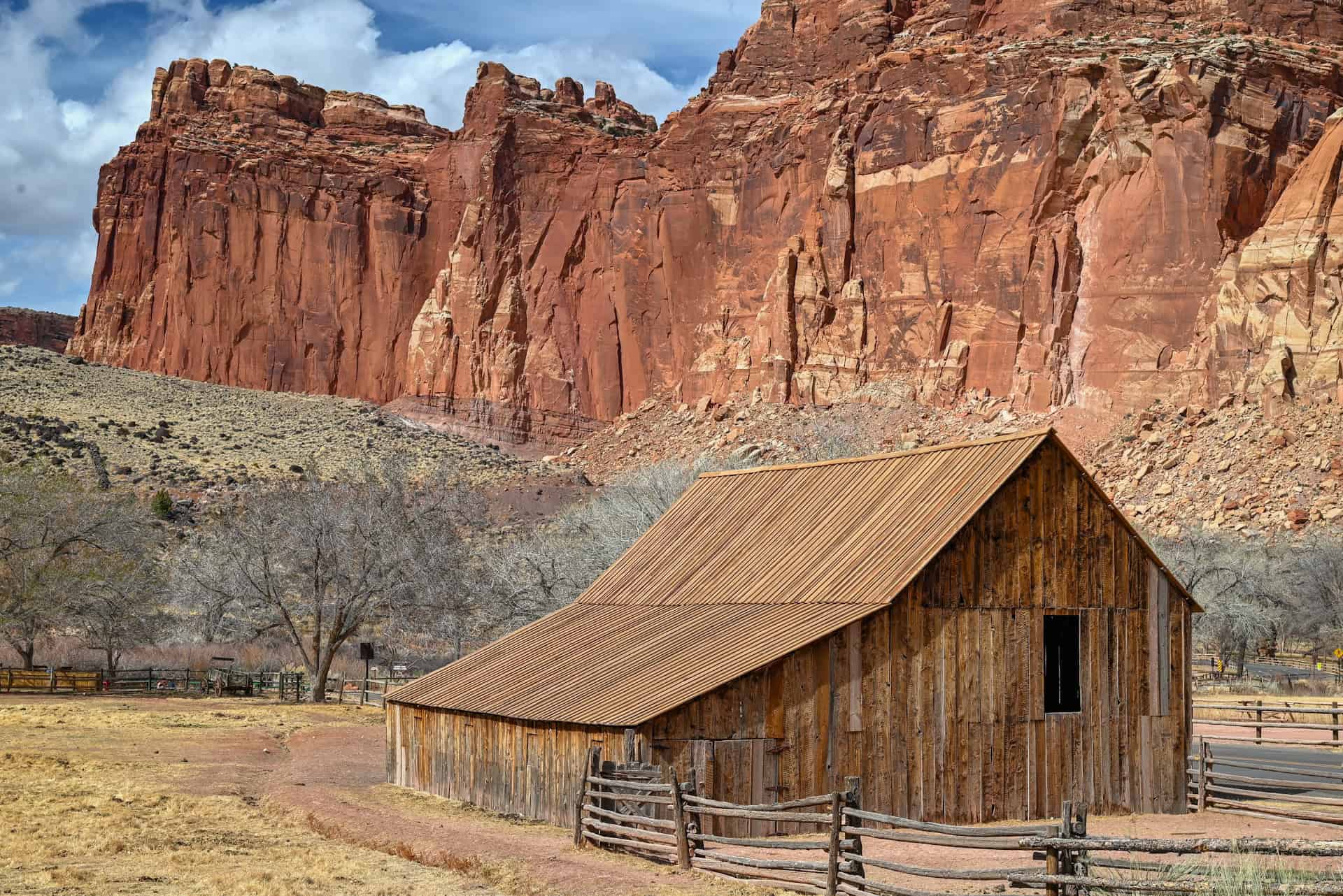
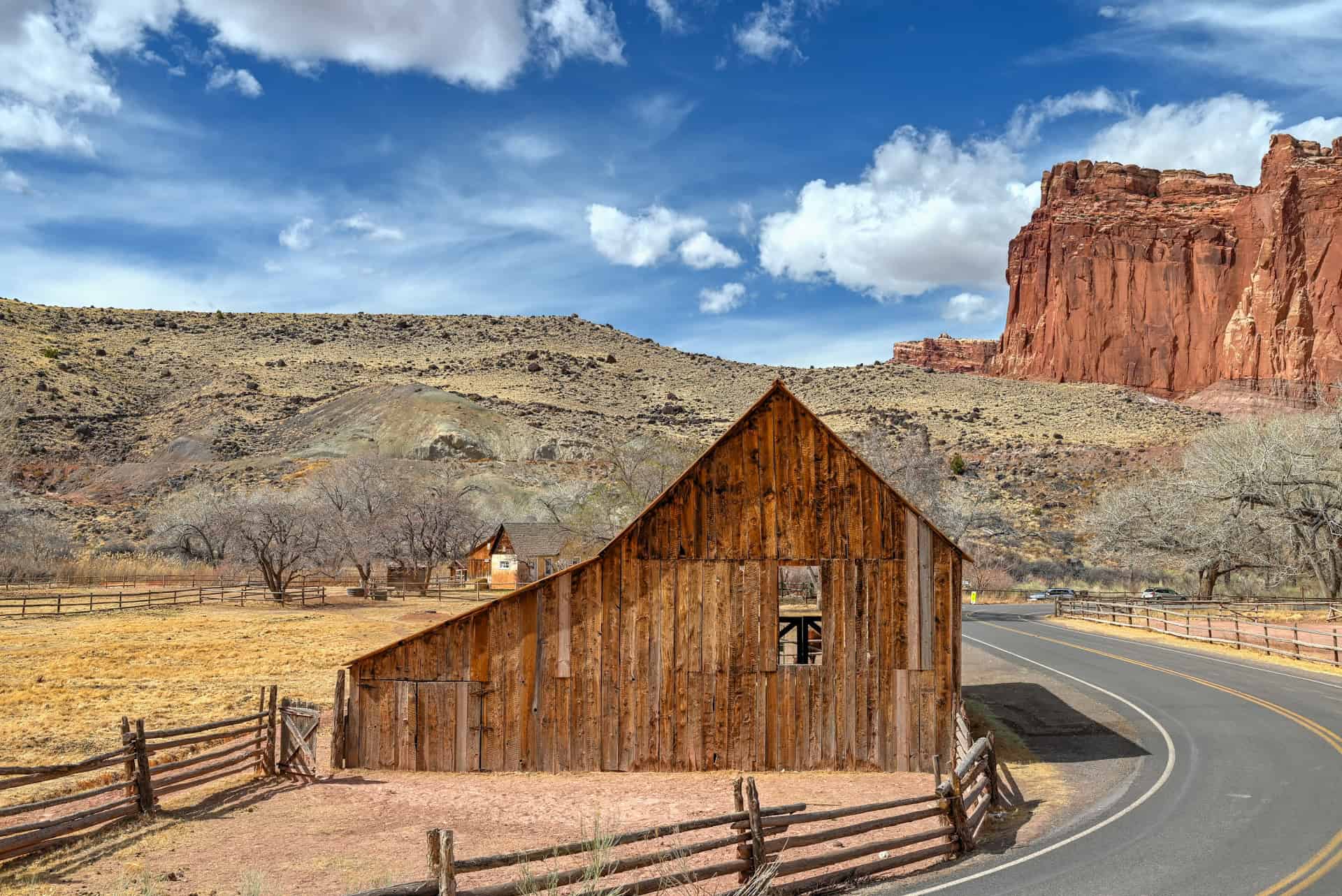
Gifford Homestead & Fruita Barn
The historic Fruita district is a rare oasis in the Utah desert, and it’s worth slowing down to explore. The iconic Fruita Barn (also known as the Pendleton Barn, originally built in the early 1900s by Calvin Pendleton), with its whitewashed wood, framed by red cliffs, is one of the most photographed spots in Capitol Reef (link to Google Maps). After establishing a farming settlement in the late 1800s here along the Fremont River, Fruita’s Mormon families moved away over time (most by the 1950s), at which point the barn fell under the protection of the National Park Service, which has preserved it as part of Capitol Reef’s cultural history. The barn serves as an iconic reminder of the pioneer lifestyle in southern Utah.


Just down the road, the Gifford Homestead (link to Google Maps), also built by Calvin Pendelton in 1908, offers a living connection to the area’s Mormon pioneer past. Today, the former kitchen (a non-historic addition to the original house) has been converted into a Natural History Association sales outlet. Visitors come for the homemade pies, breads, and jams (many of which are made from fruit grown in the surrounding orchards). Depending on the season, you can even pick your own fruit from the park’s trees, just as the settlers once did. The area around the Gifford Homestead is a delightful mix of history, scenery, and food, and the perfect place to recharge after a hike.

The Gifford Homestead is seasonally open from March 14 (Pi Day) until late November, and its daily hours are typically open daily from 9 am to 4:30 pm (but they usually close for a lunch break from 12-12:45). You can confirm current hours on the Capitol Reef NPS website.
The Pies: Even though they close in the late afternoon, their pies often sell out by midday, so it’s best to get there early if you want to secure one.
Fruit Picking: The Gifford Homestead fruit picking season typically runs from mid-August to mid-October for apples, and early August to early September for pears. You can also pick peaches from late July to early September and apricots from late June to mid-July, though you can expect yearly variations on the exact ranges depending on how cold (or warm) the previous winter was.
Time required: 30–45 minutes, depending on whether you’re just grabbing a pie or also exploring the barn, orchards, and surrounding historic area.
Spectacular Viewpoints
Capitol Reef has no shortage of jaw-dropping views, and several of the best are just minutes from the main road. Panorama Point (link to Google Maps), located just off Highway 24, offers a sweeping vista across cliffs, canyons, and the Waterpocket Fold, an ideal place to get your bearings when you first arrive in the park. A short drive beyond lies the Fluted Wall (link to Google Maps), a striking stretch of parallel sandstone ridges shaped by erosion, glowing red in the afternoon sun. These quick stops don’t require more than 10–15 minutes each, yet they showcase Capitol Reef’s geology on a grand scale. If you’re short on time, viewpoints like these offer some of the park’s most memorable scenery without the need for a long hike.


Time required: 15–30 minutes total if you stop at Panorama Point and the Fluted Wall for quick photos and a look around.
Time Needed to Complete This One-Day Itinerary
If you total up the time estimates for each of the stops and hikes above, you’re looking at roughly 3¾ to 6 hours to see everything at a relaxed pace. Realistically, plan for closer to 6 hours if you want to experience all the highlights, especially if you plan on moving on from Capitol Reef before the day’s end.
Many travellers visit Capitol Reef as part of a longer journey between Bryce Canyon and Moab, which takes about 4½ to 5 hours of driving (the latter if you follow the scenic Highway 12 between Bryce Canyon and Torrey). In that case, you may want to shorten your visit to fit the day’s schedule..
The easiest way to keep your Capitol Reef stop under 4 hours is to skip the Scenic Drive Road and walk only part of the Grand Wash Trail, both of which still allow you to enjoy the park’s signature scenery without feeling rushed.
Ideas if You Have More Time in Capitol Reef
If you’re spending the night in Capitol Reef or staying nearby in Torrey or Hanksville, you’ll have the luxury of a bit more time to explore beyond the main highlights. The park’s vastness rewards those who linger, whether that means adding another trail or venturing deeper into its backcountry roads.
Hiking
If you are mostly interested in hiking trails, aside from Hickman Bridge and Grand Wash, two of the park’s more popular trails are the Cassidy Arch Trail (link to Google Maps), whose trailhead lies at the western end of the Grand Wash trail, and the Chimney Rock Trail (link to Google Maps), whose trailhead is just off Highway 24, near the western end of the park, close to Torrey. You can expect each of these hikes to take about 1h30-2 hours, and both rate as moderate hikes.
Scenic Drives
If you have a high-clearance 4WD vehicle and extra time, consider venturing onto one of Capitol Reef’s legendary backroads, each offering an entirely different experience of the park’s remote beauty.
Cathedral Valley Road (recommended for full-day adventures – link to Google Maps) is part of a rugged 58-mile (93 km) loop through the park’s northern reaches, where colossal monoliths like the Temple of the Sun and Temple of the Moon rise from the desert floor. Expect otherworldly solitude, expansive views, and a true sense of wilderness. The drive takes approximately 4 hours without stops, and you’ll have to ford the Fremont River, which is typically no more than a foot deep.
The Burr Trail (accessible from the south via Boulder or Notom-Bullfrog Road – link to Google Maps) cuts through the eastern Waterpocket Fold. It’s a spectacular unpaved route with tight switchbacks, colorful canyons, and viewpoints overlooking the Henry Mountains. Even driving a short portion offers a thrilling sense of scale, though completing the full route to Bullfrog Marina takes 3–4 hours one-way.
Scenic Viewpoints and Attractions
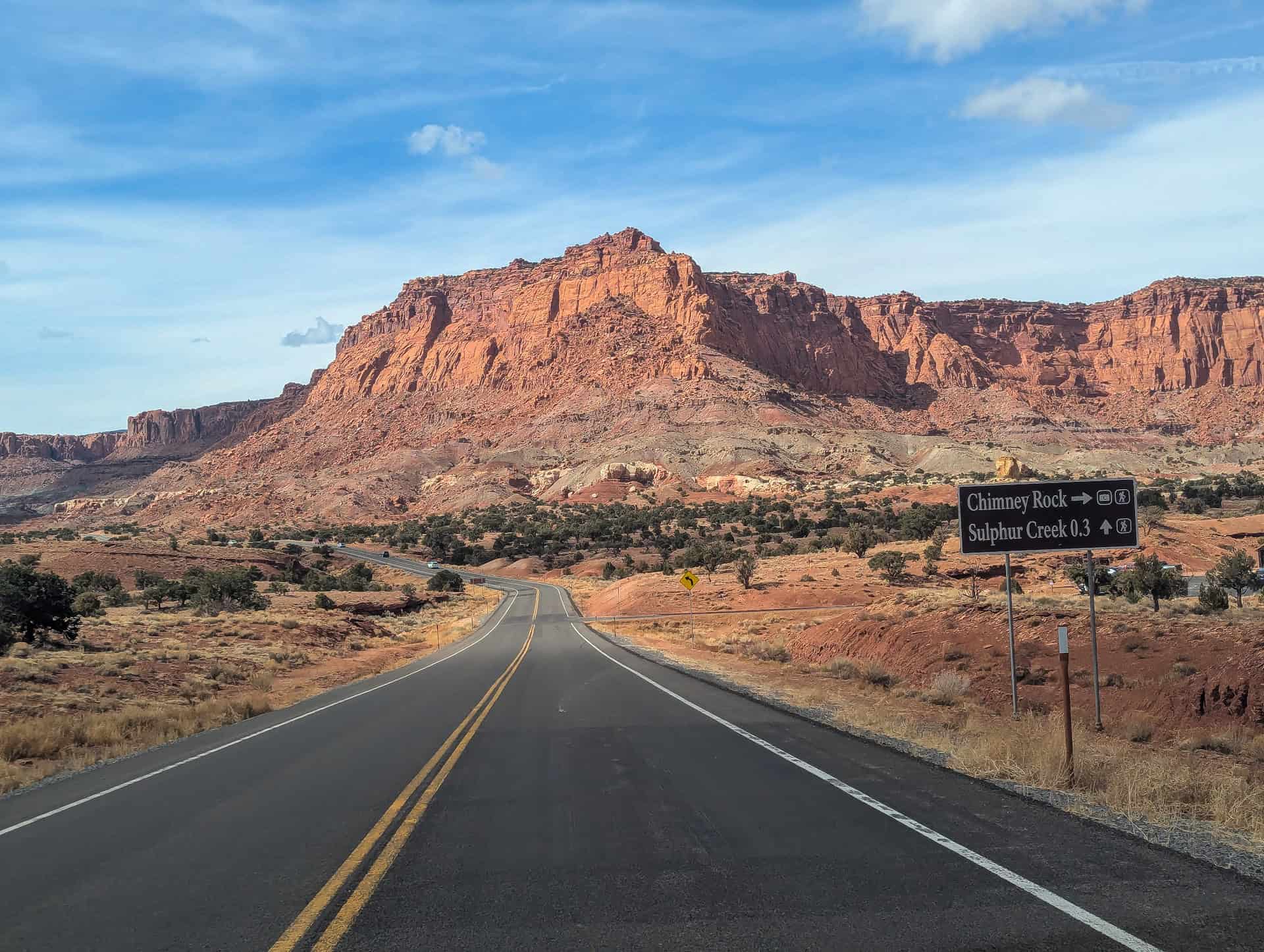
There are several scenic viewpoints and quick roadside stops along Highway 24 that are well worth a short detour. For panoramic vistas, head just west of Panorama Point (described above) and follow the short, unpaved Goosenecks Road (link to Google Maps). It’s less than a mile long and suitable for most vehicles in dry weather. At the end, you’ll find Goosenecks Overlook, where the Sulphur Creek canyon twists sharply below in dramatic curves carved deep into the sandstone. From there, a brief 10-minute trail leads to Sunset Point, one of the park’s best spots to watch the evening light ignite the cliffs in gold and red hues.
A few other stops along Highway 24 offer fascinating glimpses into Capitol Reef’s human history. The Fremont Petroglyph Panels (link to Google Maps), visible from a short boardwalk east of Fruita, feature ancient rock carvings made by the Fremont people over a thousand years ago. Just a bit farther west, the restored Fruita Schoolhouse stands beside the road (link to Google Maps), preserved as it looked in the early 1900s when it served the children of the Fruita settlement. Nearby, on the east side of the Park, the small Behunin Cabin (link to Google Maps), built in 1882 by Elijah Cutler Behunin, provides a striking look at early pioneer life in the desert, where a family of 13 once lived in the tiny stone dwelling.
Together, these viewpoints and heritage stops make for quick, rewarding breaks as you drive through Capitol Reef.
Best Time to Visit Capitol Reef National Park
Capitol Reef National Park can be visited year-round, but the best months are spring (March–May) and fall (September–October), when temperatures are mild, and conditions are most comfortable.
Spring (March–May):
Mild temperatures and occasional wildflower blooms make this one of the most pleasant times to visit the park. Expect moderate crowds, especially during spring break.
Summer (June–August):
The hot, dry conditions make the visit more challenging by midday. Plan to hike early or late, carry plenty of water, and avoid the hottest part of the day.
Fall (September–October):
Cooler air and long golden light make fall an excellent season for photography and comfortable hiking. Trails are quieter than in summer, but still fairly busy on weekends.
Winter (November–February):
The trails are open year-round, and snow is usually light. Cold mornings and icy patches can make footing tricky, so wear sturdy shoes with a good grip. The low winter sun often creates dramatic lighting on Hickman Bridge itself, making for beautiful photos.
Quick Summary – When to Visit
For the most enjoyable conditions, spring and fall are ideal. Summer is manageable if you start early and prepare for the heat. Winter offers solitude and striking scenery, though you’ll need to dress in layers and watch your footing.
What Else to See and Do Near Capitol Reef
If you have a little extra time in your Utah itinerary (or you’re staying overnight in nearby towns like Hanksville, Torrey, or Boulder), there are several excellent side trips within easy reach of Capitol Reef. Many can be comfortably explored in a half day and offer a deeper look into Utah’s mesmerizing canyon and desert landscapes. Stops near Hanksville highlight the surreal badlands and lunar landscapes east of the park, while destinations toward Boulder and Escalante showcase the lush canyons and waterfalls of Utah’s high desert.
Near Hanksville
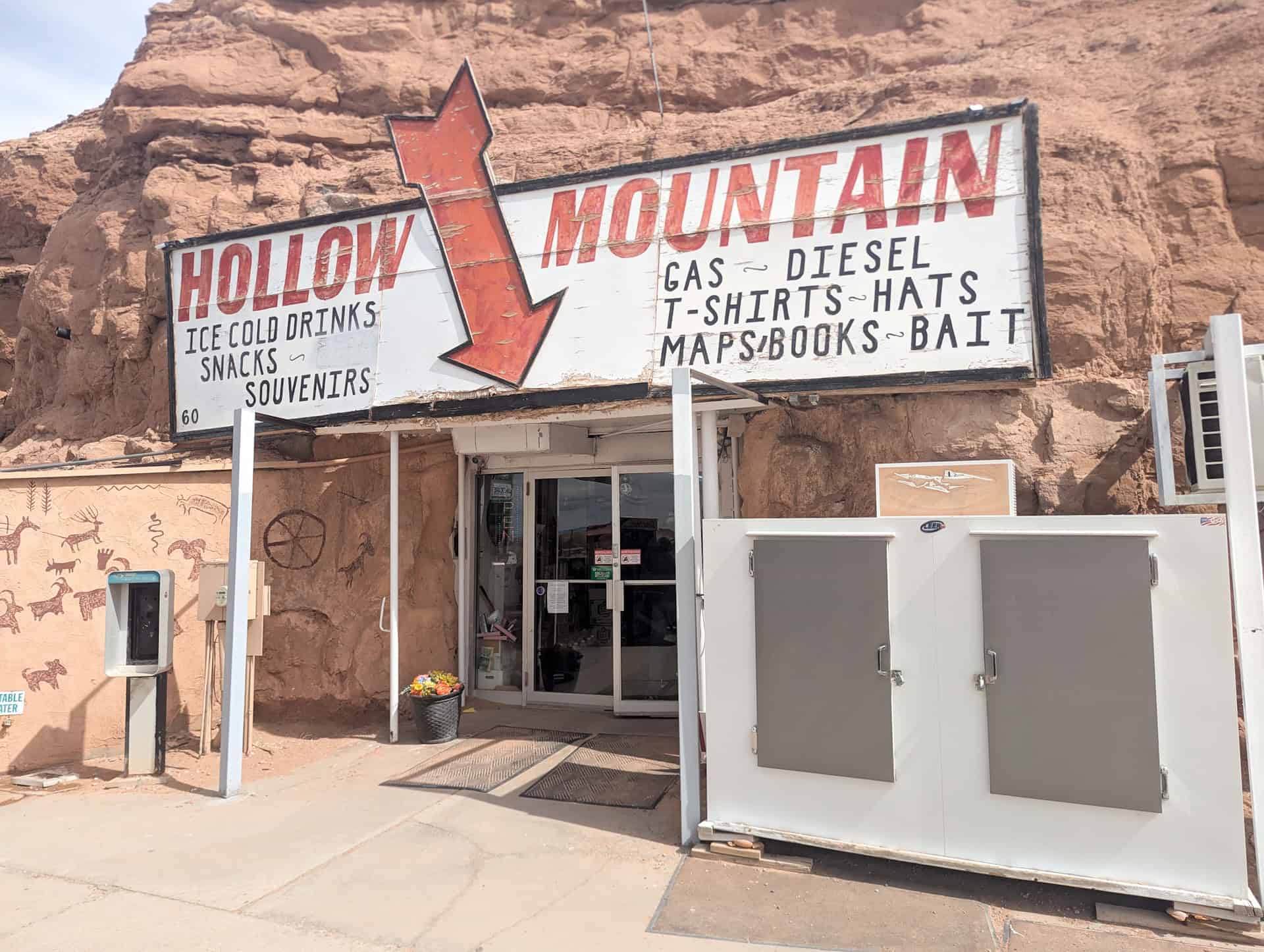
Hollow Mountain – (35 minutes from Fruita – link to Google Maps)
Just before you reach the small town of Hanksville, you’ll find this quirky roadside stop where a convenience store has been carved directly into a sandstone cliff. It’s a fun, quick stop for photos and cold drinks, a bit of classic Utah desert Americana.
Wolverton Mill – (40 minutes from Fruita – link to Google Maps)
Located about 5 miles southwest of Hanksville, this restored 1920s mill once processed ore from the nearby Henry Mountains mines. The historic structure and interpretive panels offer a glimpse into the area’s mining heritage.


Factory Butte – (45 minutes from Fruita- link to Google Maps)
An icon of Utah’s badlands, Factory Butte rises from the desert floor in dramatic fashion. You can reach the area via Factory Butte Road, an unpaved but generally well-graded route suitable for most vehicles when dry (though high clearance helps). The stark gray landscape around the butte is a favorite of photographers, especially at sunrise or sunset.
Moon Overlook (Moonscape Overlook) – (50 minutes from Fruita – link to Google Maps)
For one of Utah’s most surreal views, continue past Factory Butte toward Moonscape Overlook, where you’ll find a panoramic viewpoint over blue-gray clay hills that look straight out of another world. The final stretch to get there involves rough, unpaved roads that are best handled with a high-clearance 4WD vehicle.
Skyline Rim – (55 minutes from Fruita – link to Google Maps)
This remote overlook east of Hanksville offers sweeping desert panoramas toward the Henry Mountains and the badlands surrounding Factory Butte. Getting there involves rough, unpaved roads that are best handled with a high-clearance 4WD vehicle. It’s a fantastic off-the-beaten-path experience for those prepared for true desert driving.
Near Boulder and Escalante
Lower Calf Creek Falls Trail – (1 hr 15 min from Fruita – link to Google Maps)
One of the crown jewels of Grand Staircase–Escalante National Monument, this 6-mile (9.6 km) round-trip trail leads to a 126-foot (38 m) waterfall cascading into a beautiful pool surrounded by sheer sandstone cliffs. The trail follows the canyon floor and features ancient Fremont petroglyphs and lush riparian vegetation along the way. Allow 2½ to 3 hours to complete the hike, longer if you plan to relax by the falls. The trailhead has limited parking and fills early during peak season.
Kiva Koffeehouse – (1 hr 20 min from Fruita – link to Google Maps)
Built of stone and timber and perched high above the Escalante River canyon, this café is as much an architectural gem as a scenic stop. Grab a coffee and enjoy jaw-dropping views from the wraparound windows. It’s open seasonally (spring through fall), so check hours in advance.
Scenic Overlooks (Boynton and Head of the Rocks) – (1 hr 30 min from Fruita – link to Google Maps)
Two of Highway 12’s most breathtaking pullouts. The Boynton Overlook provides sweeping views of the slickrock canyons surrounding the Escalante River, while Head of the Rocks Overlook reveals one of the most iconic vistas in Utah: miles of undulating sandstone that seem to stretch into infinity. Both are paved, easily accessible, and ideal for photography or a quick roadside stop..


Goblin Valley State Park
About 1 hour and 15 minutes northeast of Capitol Reef, this otherworldly landscape is filled with thousands of mushroom-shaped sandstone hoodoos, nicknamed “goblins.” The short, interconnected trails let you wander freely among the formations, making it a fun stop for families and photographers alike. The park is small but incredibly photogenic, especially at sunrise or sunset when the warm light enhances the red rock textures. Its proximity to Capitol Reef makes it a perfect half-day side trip or an easy detour on the drive toward Arches National Park and Moab.


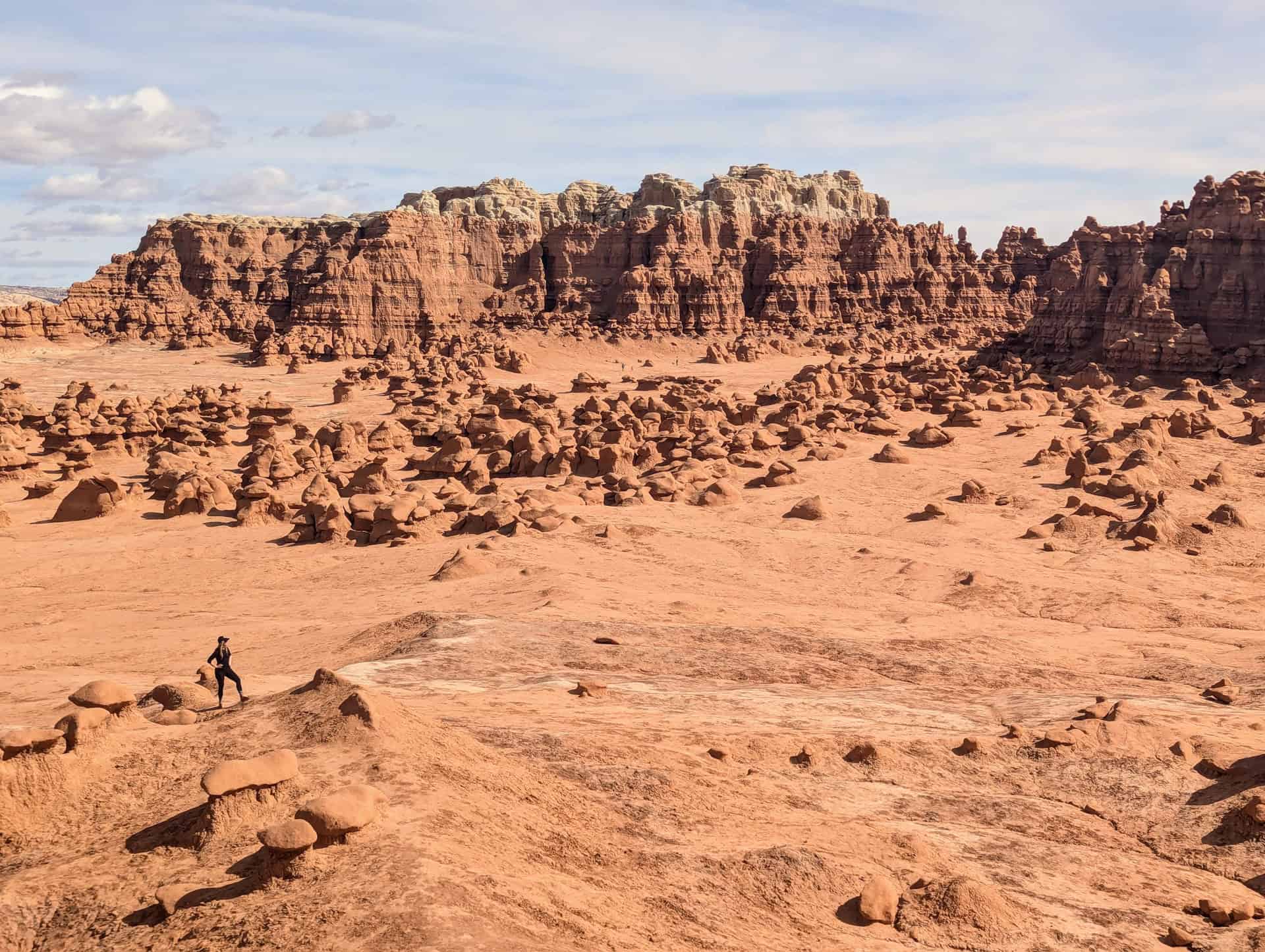
For more information on visiting this otherworldly place, be sure to check out our Goblin Valley State Park Visiting Guide.
Where to Stay Near Capitol Reef
While there’s no traditional lodging inside Capitol Reef National Park, visitors can camp within the park at the Fruita Campground or designated backcountry sites. For those seeking hotels, cabins, or inns, the best options lie just outside the park in small nearby towns, each offering its own charm and convenience. The closest is Torrey, located just 5 miles (8 km) west of the park’s visitor center, while Hanksville and Caineville provide good options for travellers heading east toward Moab or Lake Powell.
Torrey
Torrey is the main gateway to Capitol Reef and has the widest range of accommodations, from cozy inns to full-service resorts. It’s also where you’ll find the best selection of restaurants and shops.
Capitol Reef Resort – The area’s most upscale lodging, offering cabin, wagon, and teepee stays with stunning views of red cliffs and on-site amenities like a pool and restaurant.
Broken Spur Inn & Steakhouse – Comfortable Western-style rooms and hearty dining just a few minutes from the park entrance.
SkyRidge Inn – A charming bed and breakfast known for its panoramic vistas and peaceful atmosphere, perfect for couples or quieter stays.
Days Inn by Wyndham Torrey Capitol Reef – A practical, budget-friendly option with simple rooms and easy highway access.
Hanksville
About 45 minutes east of Fruita, Hanksville is a small desert outpost well-positioned for exploring Capitol Reef’s eastern side or nearby Goblin Valley State Park.
Whispering Sands Motel – A clean, comfortable classic roadside motel with friendly service, ideal for travellers continuing toward Moab or Lake Powell.
Caineville
Halfway between Torrey and Hanksville, this tiny settlement sits in a dramatic desert setting, surrounded by badlands and open skies.
Cathedral Valley Inn – A peaceful and simple motel popular with photographers and off-road adventurers, offering quick access to the Cathedral Valley Loop and other remote park areas.
Capitol Reef National Park – Frequently Asked Questions
Do I need a park pass to visit Capitol Reef?
If you’re just driving straight through on Highway 24 without stopping, no entry fee is required. However, anyone stopping to hike, sightsee, or drive the Scenic Drive Road must pay the Capitol Reef National Park entry fee (currently $20 per vehicle, valid for seven days). Fees can be paid at the visitor center or via self-pay stations near the start of the Scenic Drive.
Can I see the park’s highlights in one day?
Yes! Capitol Reef is one of Utah’s most accessible national parks for a short visit. Many of its best attractions, like Hickman Bridge, Grand Wash, the Fruita orchards and Gifford Homestead, and the Scenic Drive, are located just minutes apart. You can comfortably experience the park’s major highlights in 4 to 6 hours, depending on how many stops and hikes you include.
What’s the best order to visit the attractions?
It doesn’t matter much which order you do them in since it’s only about a 10-minute drive between the easternmost and westernmost points of this itinerary. However, if visiting on a hot summer day, we recommend starting early with the most exposed hike (Hickman Bridge) before moving on to Grand Wash, followed by the drives and viewpoints, and finishing with a treat at Gifford Homestead.
When is the best time of year to visit Capitol Reef?
Spring (March–May) and fall (September–October) offer the most pleasant temperatures for hiking and sightseeing. Summer brings intense heat, especially in exposed areas, while winter offers solitude and beautiful lighting but colder conditions. The park is open year-round, and each season offers its own rewards.
Can I drive the Scenic Drive Road in any vehicle?
Yes, the 7.9-mile paved Scenic Drive is suitable for all passenger vehicles. However, the side roads to Capitol Gorge and Grand Wash are unpaved, and while usually accessible to standard cars in dry conditions, high-clearance vehicles are recommended after rain or during wet seasons.
Are there food or lodging options in the park?
Capitol Reef itself has limited services. There’s a small picnic area near the visitor center, and the Gifford Homestead sells baked goods and snacks in season. For restaurants, groceries, and accommodations, head to Torrey, located about 10 minutes west of the visitor center.
Can I pick fruit in the Fruita orchards?
Yes! When the fruit is in season (typically June through October, depending on the variety), visitors can pick cherries, peaches, apples, and pears from the historic Fruita orchards. Bags and payment are available on-site through a self-serve honor system.
What if I have more than one day in Capitol Reef?
If you have extra time, consider tackling moderate hikes like Cassidy Arch or Chimney Rock, or exploring Cathedral Valley or the Burr Trail Road, both of which require more driving and, in some cases, high-clearance vehicles, but reward you with incredible remote desert scenery.
Explore More Utah National & State Park Guides
Continue exploring Utah with these detailed guides:
Bryce Canyon National Park Guide
Zion National Park Guide
Goblin Valley State Park Guide
Arches National Park Guide
Canyonlands National Park
Photography Gear
If you like our photography, you might be interested in some of the gear we use to shoot our travel and hiking destinations.
Camera Body – Nikon Z 6ii Fx-series Mirrorless Body
Main Lens – NIKON 24-120mm F/4G ED VR AF-S
Zoom Lens – Sigma 745-306 150-600mm f/5-6.3
Polarizing filters – Urth Circular Polarizing (CPL)
Camera Tripod – K&F Concept 64-inch Camera Tripod
Mini-tripod – Lammcou Flexible Camera Tripod
Camera/hiking backpack – Vanguard Alta Rise 48 Backpack
Universal Travel Adapter – VYLEE Universal International Power Travel Plug
Other Travel Essentials
Travel Insurance
SafetyWing is a travel insurance company that offers comprehensive coverage for travellers. Includes Medical Insurance and Travel Insurance. Primarily geared towards long-term travellers, digital nomads, and expats.
e-Sim cards
Airalo is the world’s first and largest eSIM store with eSIM plans for 200+ countries and regions worldwide. With Airalo eSIMs, travellers can get connected the moment they land at their destination and avoid nasty data roaming charges
eSIMS are a sustainable alternative to single-use SIM cards – they are 100% digital, require less energy to produce and be re-used rather than disposed of.
Car Rentals
Discover Cars is our go-to website for car rentals. We almost always find our preferred rate there.
Transfer from Airport
Welcome Pickups is our favourite private transfer service, which you can pre-book at a fixed price. Currently available in 220 cities all over the world (mostly in Europe, but with several major cities in Asia, the Middle East and the US).
Kiwitaxi is another private transfer service – we haven’t tried it yet, but it’s currently available in a few more countries (102 as of 2024).
Hotels and Accommodations (coming soon)
Photography Prints
If you found this blog useful, you can help support our blog by purchasing low-cost digital prints. Printed physical prints are also available for purchase.


—–
Well, that wraps it up! We hope you enjoyed our One Day in Capitol Reef National Park guide and that it will prove useful for planning your trip.
—–
You might also be interested in these related pages: