The Soldier Pass Trail is one of Sedona’s most diverse and exciting hikes, blending spectacular geology, forested canyons, and a touch of mystery. In just a few miles, you’ll encounter three of Sedona’s most photographed natural features — the Devil’s Kitchen Sinkhole, the Seven Sacred Pools, and the Soldier Pass Cave — each offering a glimpse into the area’s rich natural and cultural history. The route starts in the heart of red rock country, winding through juniper forest and sandstone formations before climbing toward panoramic views and hidden alcoves. To help you plan your visit, we’ve put together this Soldier Pass Cave Trail hiking guide, covering everything from trail difficulty and estimated hiking time to what to expect along the route. Whether you’re after a short scenic outing or a half-day adventure with some scrambling, Soldier Pass delivers one of Sedona’s most rewarding trail experiences in northern Arizona.
Soldier Pass Highlights – At a Glance
Sedona’s ultimate highlights trail – Few hikes in Sedona pack so much variety into such a short distance. Soldier Pass leads you from the forest floor to open slickrock and hidden caves, with striking red rock scenery the entire way.
Sweeping panoramic views – The first mile passes two major natural attractions: Devil’s Kitchen, a massive sinkhole still slowly collapsing, and the Seven Sacred Pools, a series of natural basins carved into the sandstone that fill seasonally after rains.
Cave adventure – For those seeking a bit more thrill, a short but steep side trail near the end leads to Soldier Pass Cave, a hidden sandstone chamber with high vaulted ceilings and windows looking out over Sedona..
A must-do Sedona classic – Whether you’re tackling a few of Sedona’s shorter hikes or stringing together a full day of red-rock exploration, Soldier Pass is an easy addition to any itinerary. It delivers the perfect mix of sightseeing and adventure


Disclosure: This page (Soldier Pass – A Sedona Hiking Guide) may contain product affiliate links. At no additional cost to you, we may receive a commission for purchases made through these links. More details can be found on our disclosure and policies page.
Soldier Pass Trail & Sedona: Location and Map
The Soldier Pass Trail is located in Sedona, Arizona, within the beautiful Red Rock Secret Mountain Wilderness area.
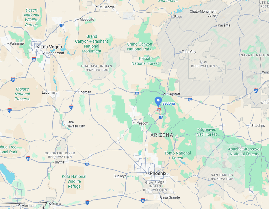
How to Get to the Soldier Pass Trail in Sedona
Unlike many other local trails, this trailhead is served by the Sedona Shuttle, which operates year-round on a set schedule (typically Thursday through Sunday).
Private vehicles are not permitted to park at the Soldier Pass Trailhead on days when the shuttle is running (even outside of shuttle hours), so hikers must use the free shuttle from the Posse Grounds Park & Ride lot.
Outside of shuttle operating hours, driving to the trailhead is the only practical option.
Driving times to Sedona, AZ
- Phoenix, AZ: 190 km / 120 mi – about 2 hours
- Flagstaff, AZ: 50 km / 30 mi – about 1 hour
- Grand Canyon (South Rim): 180 km / 110 mi – about 2.5 hours
- Prescott, AZ: 95 km / 60 mi – about 1.5 hours
- Page, AZ: 250 km / 160 mi – about 3 hours
- Las Vegas, NV: 475 km / 300 mi – about 5 hours
These times assume good weather and minimal stops.
If you need to book a rental vehicle for your hiking excursion, we highly recommend using Discover Cars to get the best rates on your rental in Utah, Nevada and Arizona.
We also highly recommend Airalo (eSIM card) for your connectivity needs when travelling abroad. Airalo is the world’s first and largest eSIM store with eSIM plans for 200+ countries and regions worldwide.
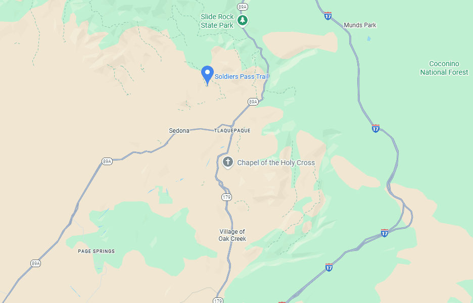
Soldier Pass Cave Trail Access, Fees, and Parking
Trailhead location: The trailhead is situated just off Soldier Pass Road, approximately 10 minutes from downtown Sedona (link to Google Maps).
Shuttle departure location: Shuttles depart from the Posse Grounds Park & Ride lot at 20 Carruth Drive, Sedona (link to Google Maps)
Sedona Shuttle Schedule: The free Sedona Shuttle, which operates year-round on a regular schedule, typically runs from Thursday through Sunday. The shuttle runs approximately every 15–20 minutes between 7 a.m. and 5:30 p.m., with a travel time of about 10 minutes each way. Check the official Sedona Shuttle website for the most up-to-date routes, schedules, and any service changes before your visit.*
*If you just missed a shuttle and prefer not to wait for the next one, it’s possible to walk between the Posse Grounds Park & Ride lot and the Soldier Pass Trailhead. The distance is about 1.5 miles (2.4 km) — slightly downhill on the way to the trailhead and uphill on the return. Most of the route follows a sidewalk along Soldier Pass Road, with only a few short sections lacking a separate walkway. Traffic is generally light, especially during shuttle operating hours. We opted to walk back to the shuttle car park after the hike after having just missed the shuttle.
Trailhead parking lot: Outside of shuttle operating hours, a small paved lot with roughly 20 spaces is available at the Soldier Pass Trailhead on a first-come, first-served basis. It often fills very early in the morning, so most visitors use the shuttle instead.
Shuttle parking lot: The shuttle parking is slightly larger, but it can fill up quickly, too. On busy weekend days, you might have to wait for a spot to open up.
Facilities: Vault toilets are available both at the trailhead and at the shuttle car park.
Trail opening Hours: Open daily 24/7.
Soldier Pass Trail Entrance Fees
Parking at the Posse Grounds Park & Ride and riding the Sedona Shuttle are free of charge. A Red Rock Pass is not required when using the shuttle system.
A Red Rock Pass is required to park at the trailhead. Passes can be purchased at the parking kiosk, at visitor centers in Sedona, or online at recreation.gov (5$ for a daily pass, $15 for a weekly pass).
If purchasing online, your license plate will need to be entered; if purchasing a physical pass, it must be displayed while parked.
Holders of an America the Beautiful Pass can enter free of charge. You can purchase your pass ahead of time through the REI store.
Soldier Pass Cave Trail Details and Map
Distance: 3 miles (4.7 km)
Route Type: Out & Back
Elevation change: 430 ft / 130 m (difference between trail high and low point)
Elevation gain: 430 ft / 130 m (cumulative elevation gain)
AllTrails rating (2025): 4.8, 12869 ratings
Duration: Most people complete the full trail in 1h15-1h45
Not an AllTrails member yet? We highly recommend signing up for either their free or paid membership plans. The free plan allows you to find new trails and plan routes but it can only be used while hiking if you have access to mobile data. The paid membership plan (AllTrails+) allows you to download trail maps for offline use and provides live progress updates and off-route notifications.
If you are still uncertain – you should know that the All Trails mobile application was voted the 2023 iPhone App of the Year by Apple.
We find that AllTrails is a great tool to have when hiking, particularly for assisting with navigation when the trail is hard to locate and to help monitor your progress along the trail, which helps estimate how much time you’ll need to complete the trail.
Additional Trail Details
Canine companions: Dogs are allowed on the Soldier Pass Trail, but they must be kept on a leash at all times. The route includes uneven terrain, exposed rock ledges, and occasional steep sections, so exercise extra caution if hiking with pets — especially near the Seven Sacred Pools and Devil’s Kitchen Sinkhole.
You can bring dogs on the Sedona Shuttle as long as they are in an appropriate carrier or have a muzzle and are on a leash.
Trail environment – The Soldier Pass Trail offers one of the most diverse landscapes in Sedona, passing the striking Devil’s Kitchen Sinkhole and the Seven Sacred Pools — a series of natural sandstone basins that often hold water after rain. Beyond these landmarks, the trail transitions to open slickrock ledges and shady pockets of pinyon pine and oak as it climbs toward Brins Mesa. Shade varies along the route — moderate in the canyon, but limited on the upper slickrock — so carry plenty of water and plan for sun exposure.
Route signage – The Soldier Pass Trail (Trail #66) is generally well-marked and easy to follow. Trail signs clearly mark major junctions — including connections with the Jordan Trail, Brins Mesa Trail, and Coyote Canyon Trail — but a few side paths can be difficult to spot, especially the Soldier Pass Cave turnoff. Downloading an offline map from AllTrails can be helpful.
The surface alternates between packed red dirt, loose rock, and sections of slickrock. The climb past the Seven Sacred Pools involves mild elevation gain, and a few short scrambles may be needed to navigate rocky ledges. These are non-technical but may require using your hands for balance. Sturdy hiking shoes with good grip are recommended, especially after rain when slickrock can become slippery.
Trail surface / Technical aspects – The trail is non-technical for the most part, consisting mostly of packed dirt, sandstone steps, and some loose rock on the switchbacks. The final section heading up to the cave is definitely more challenging as you’ll be climbing rocky and uneven terrain, which occasionally might require some light scrambling over slickrock ledges and boulders. Sturdy footwear with good grip is recommended for the ascent and descent.
Slope grade: The average trail slope grade is about 6%, which is considered fairly gentle. Most of the route maintains a mild incline, but the terrain becomes notably steeper and more uneven as you approach the cave, where footing and balance require more attention.
Trail difficulty level assessment (based on our personal assessment, taking into account the trail length, slope grade and trail surface) :
Very Easy | Easy | Moderate | Moderately Challenging | Challenging
Overall, the Soldier Pass Trail is rated Moderate. While the total distance and elevation gain are reasonable and could technically qualify as easy, the mix of rocky surfaces and short scrambles — particularly on the final stretch toward the cave — made us lean toward the moderate category. It could also be described as an Easy-to-Moderate hike overall.
Soldier Pass Trail Description and Summary
The spectacular scenery begins even before reaching the trailhead — especially on shuttle days. From the Posse Grounds Park & Ride lot, the panoramic view of Sedona’s red rock formations is already impressive, setting the stage for the hike ahead.


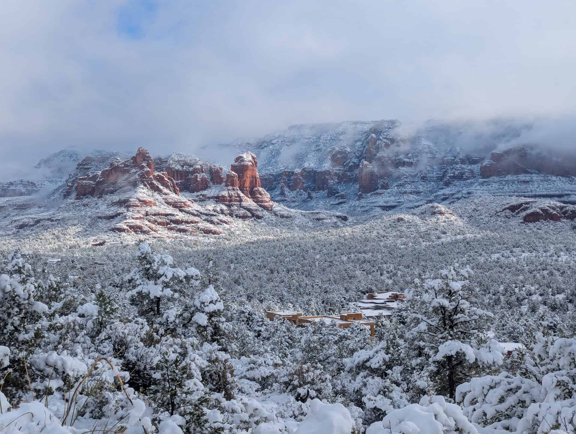
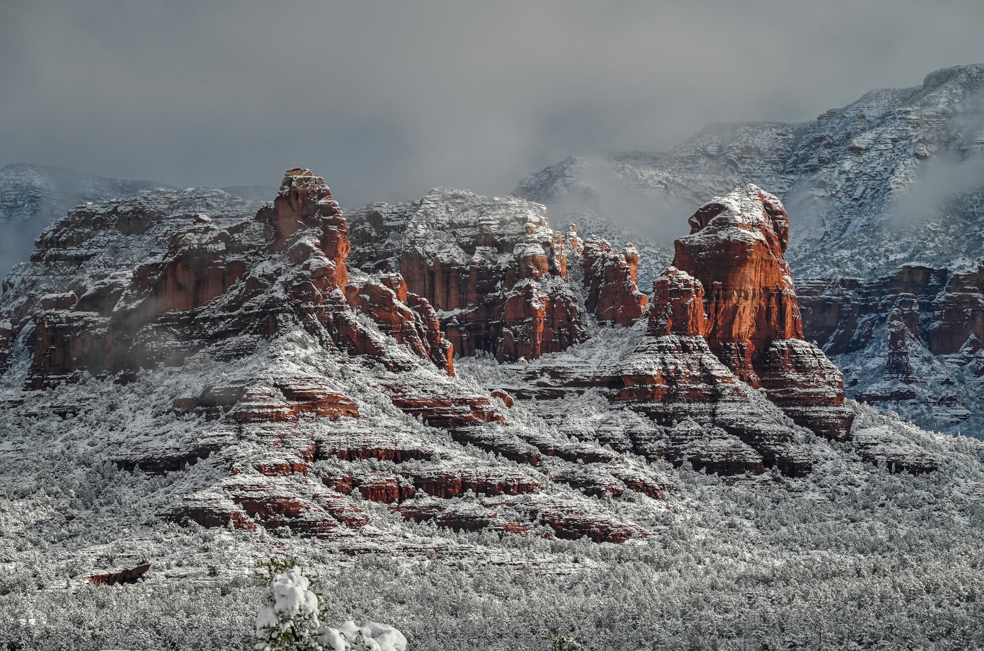
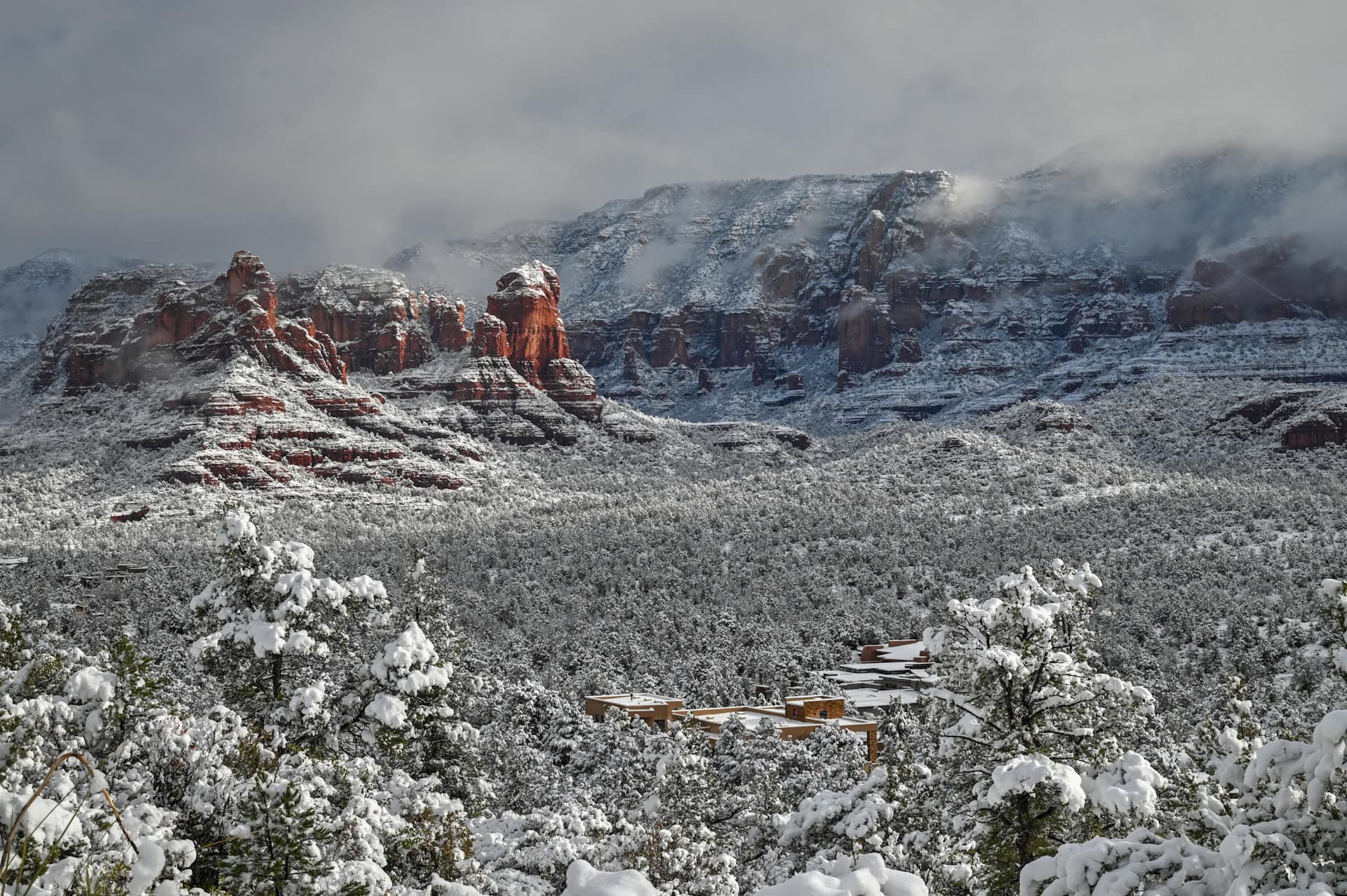
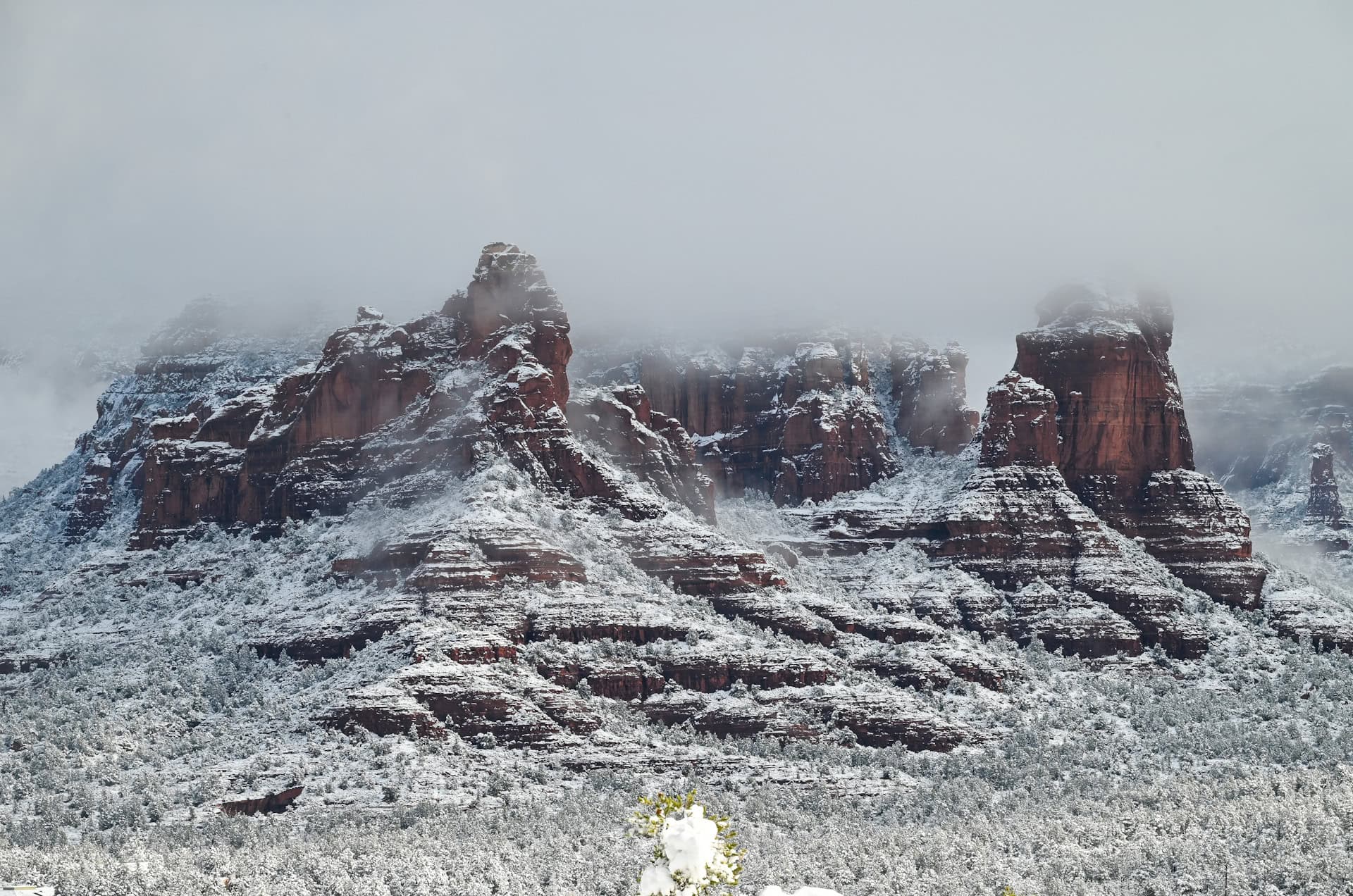
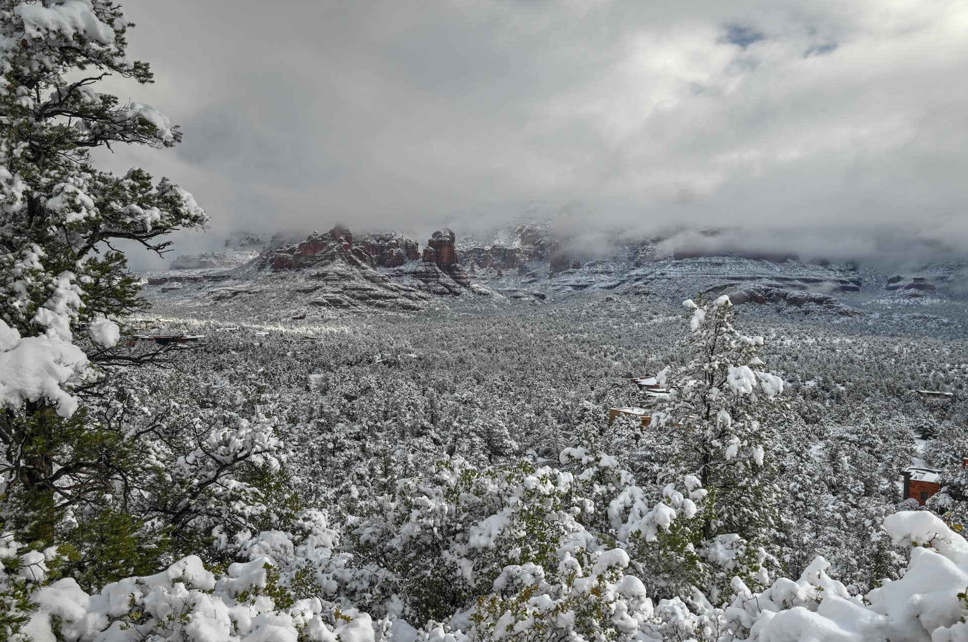
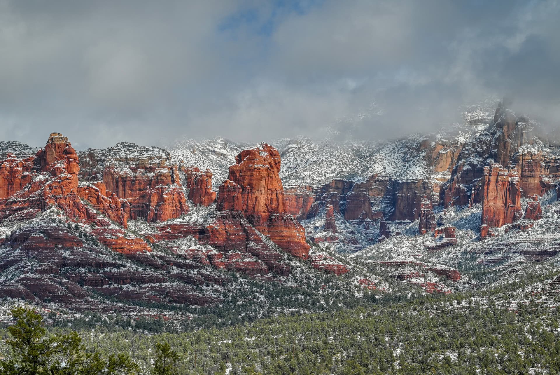
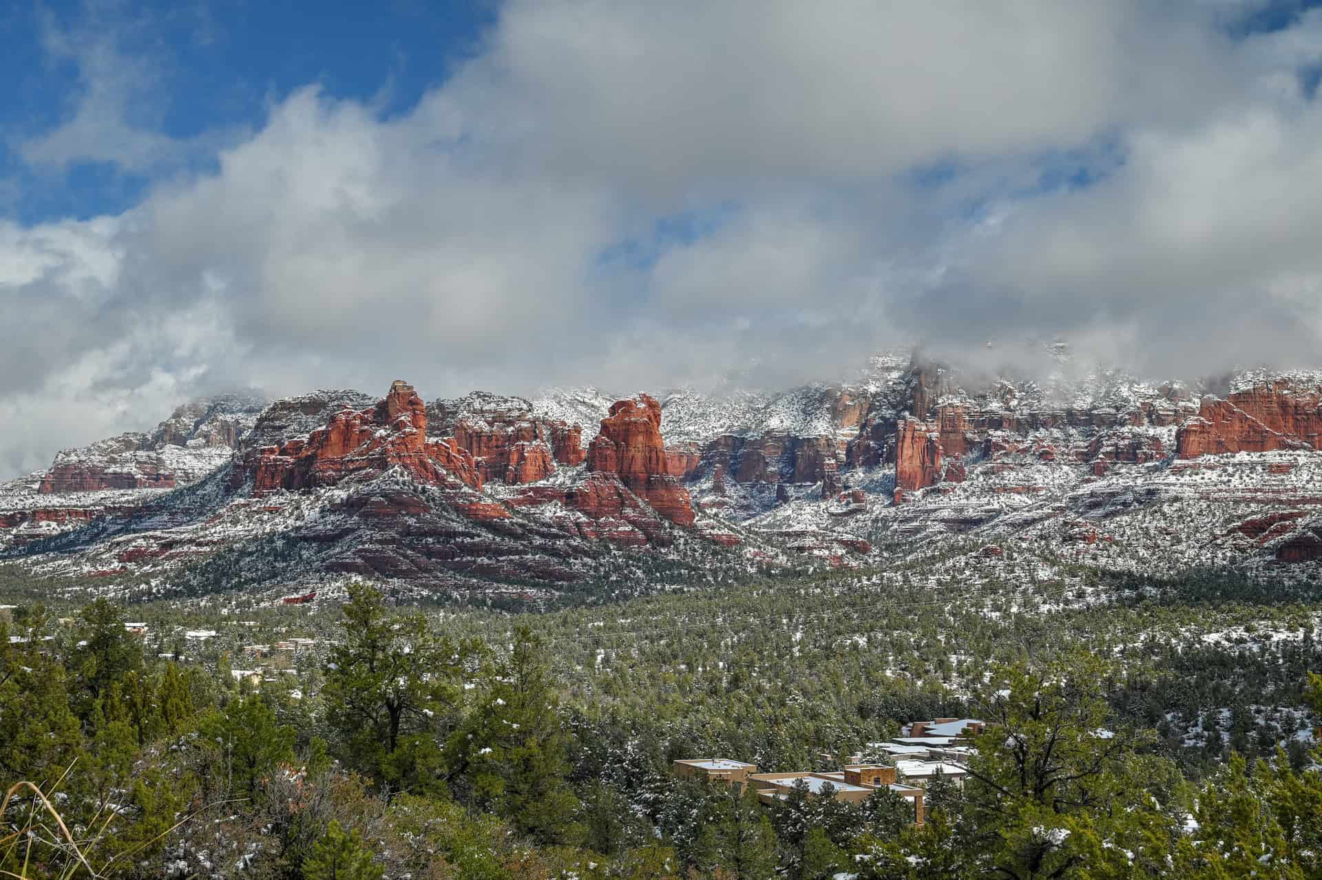
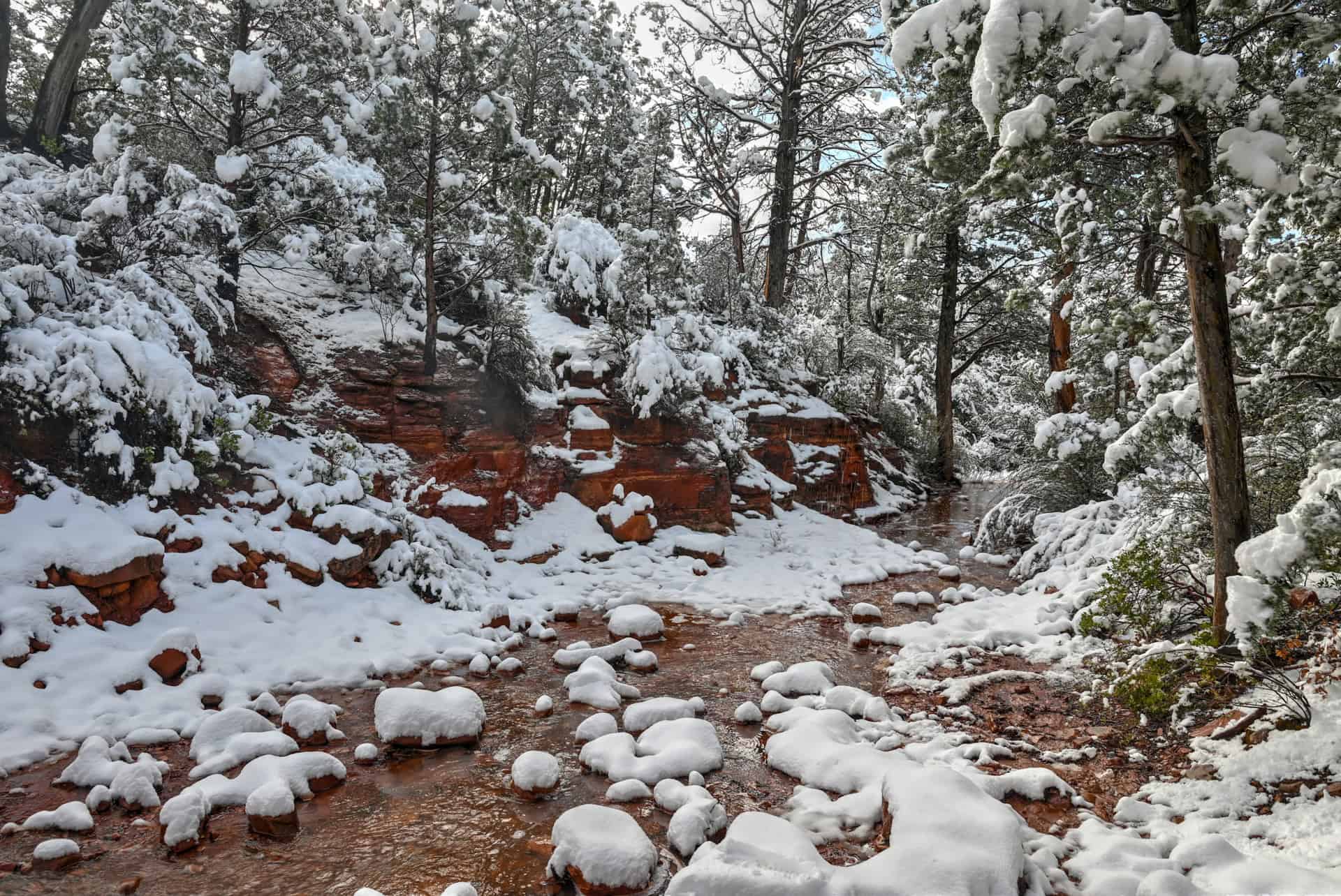
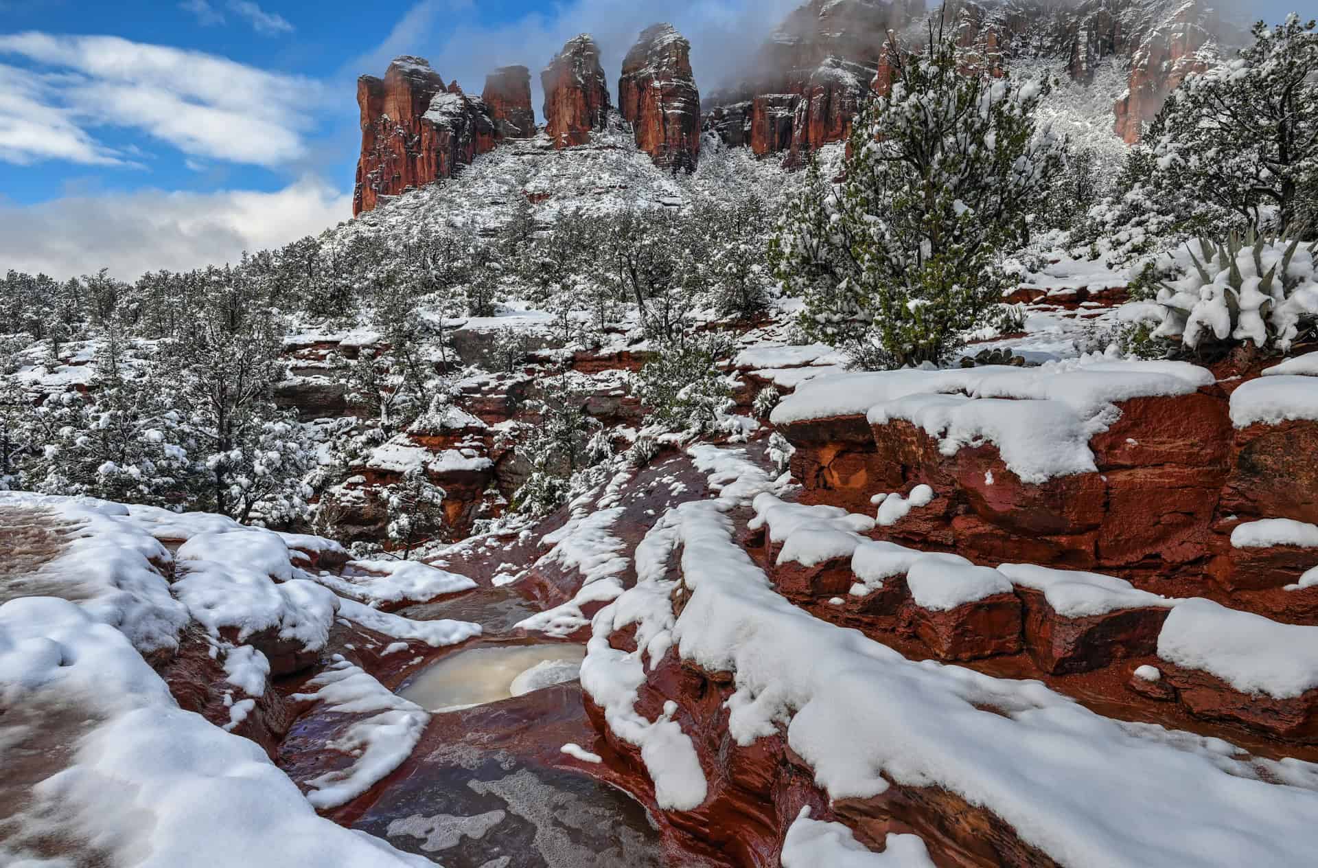
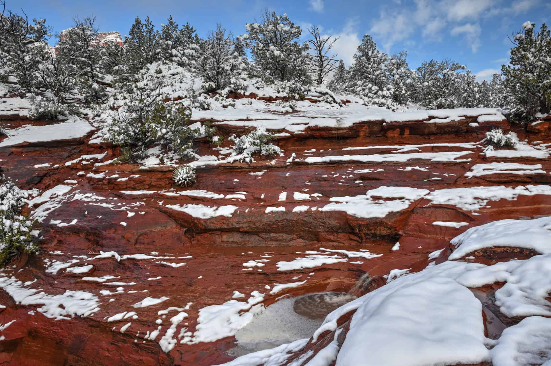
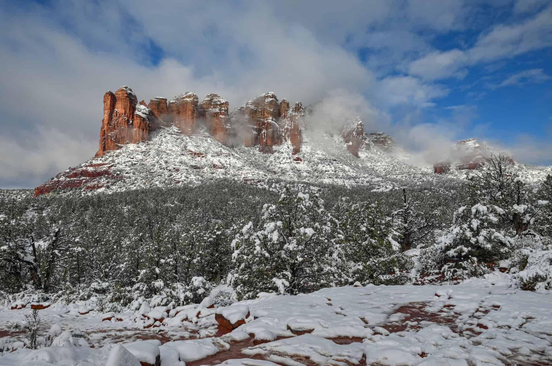
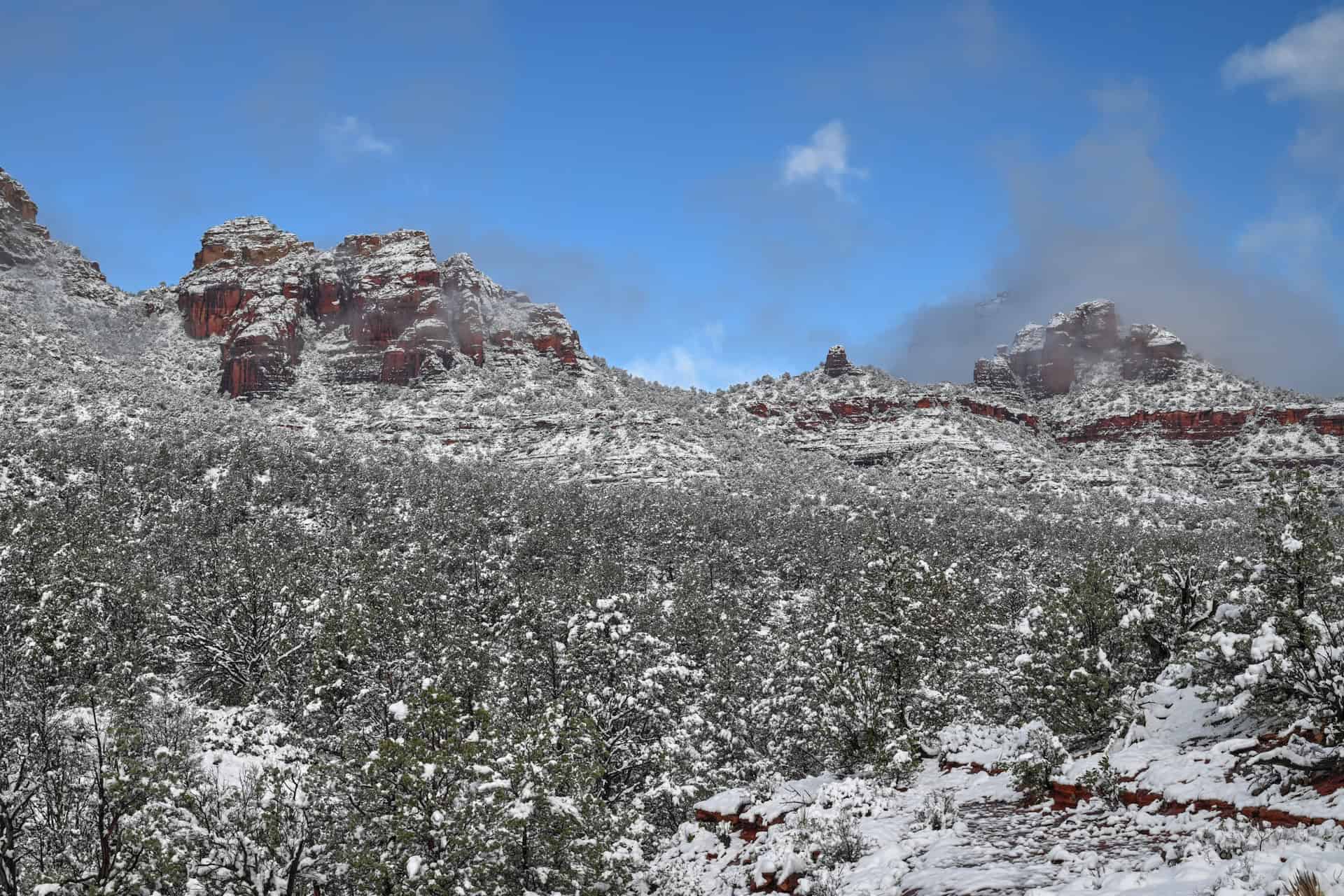
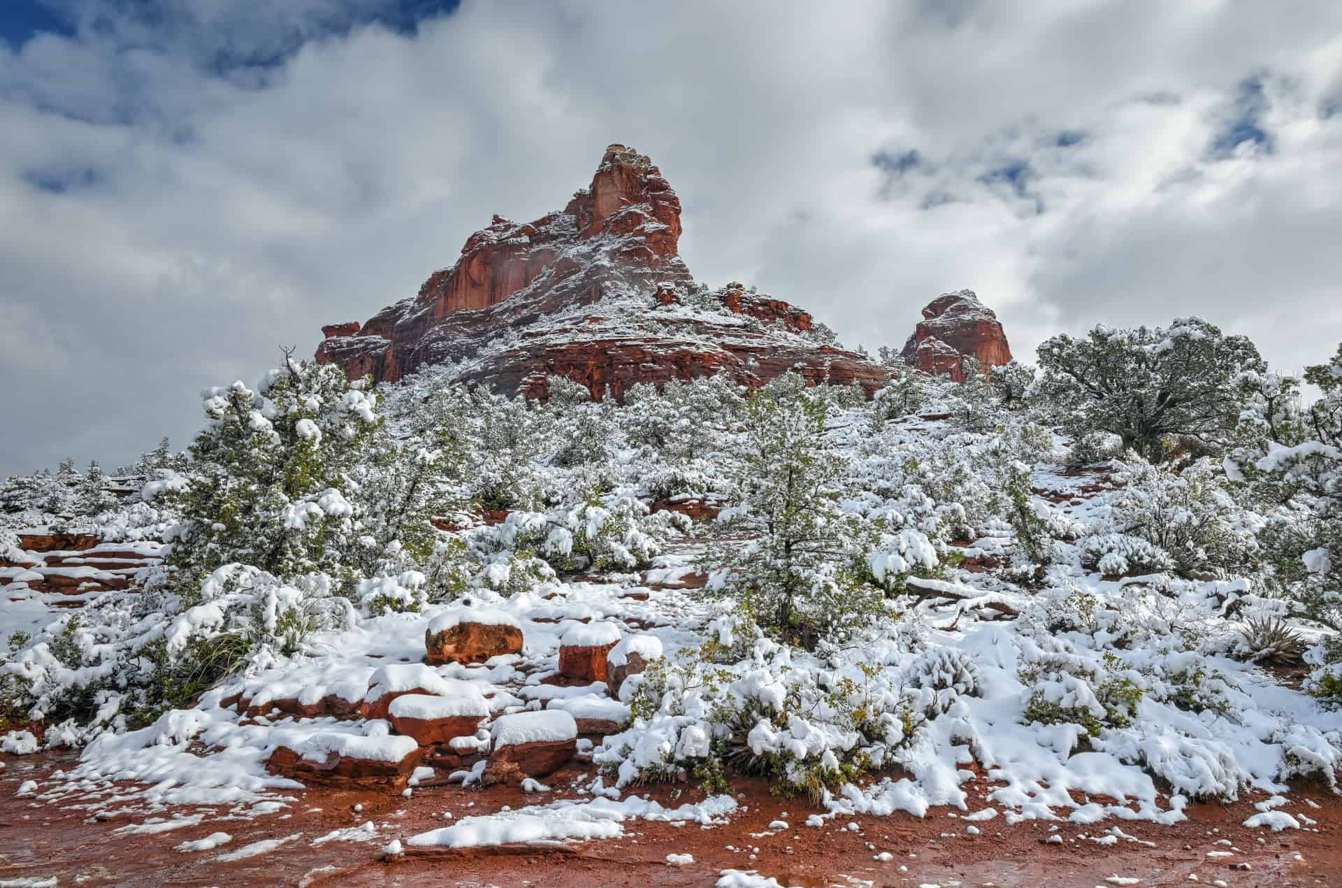
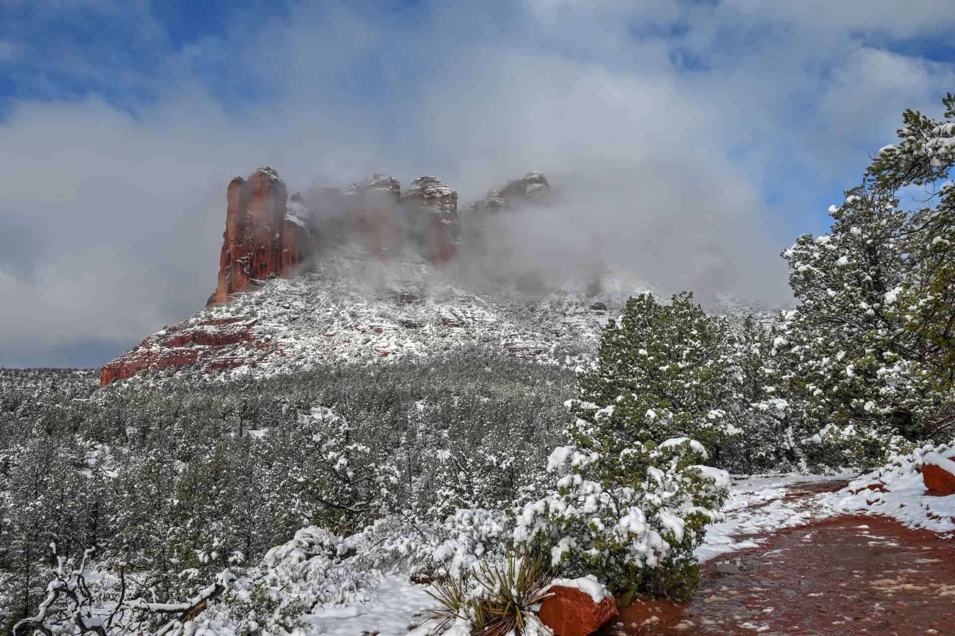
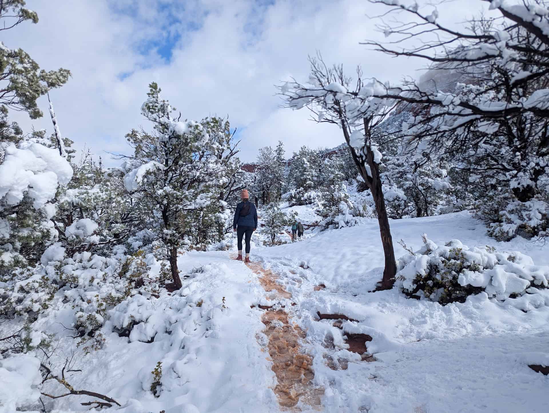
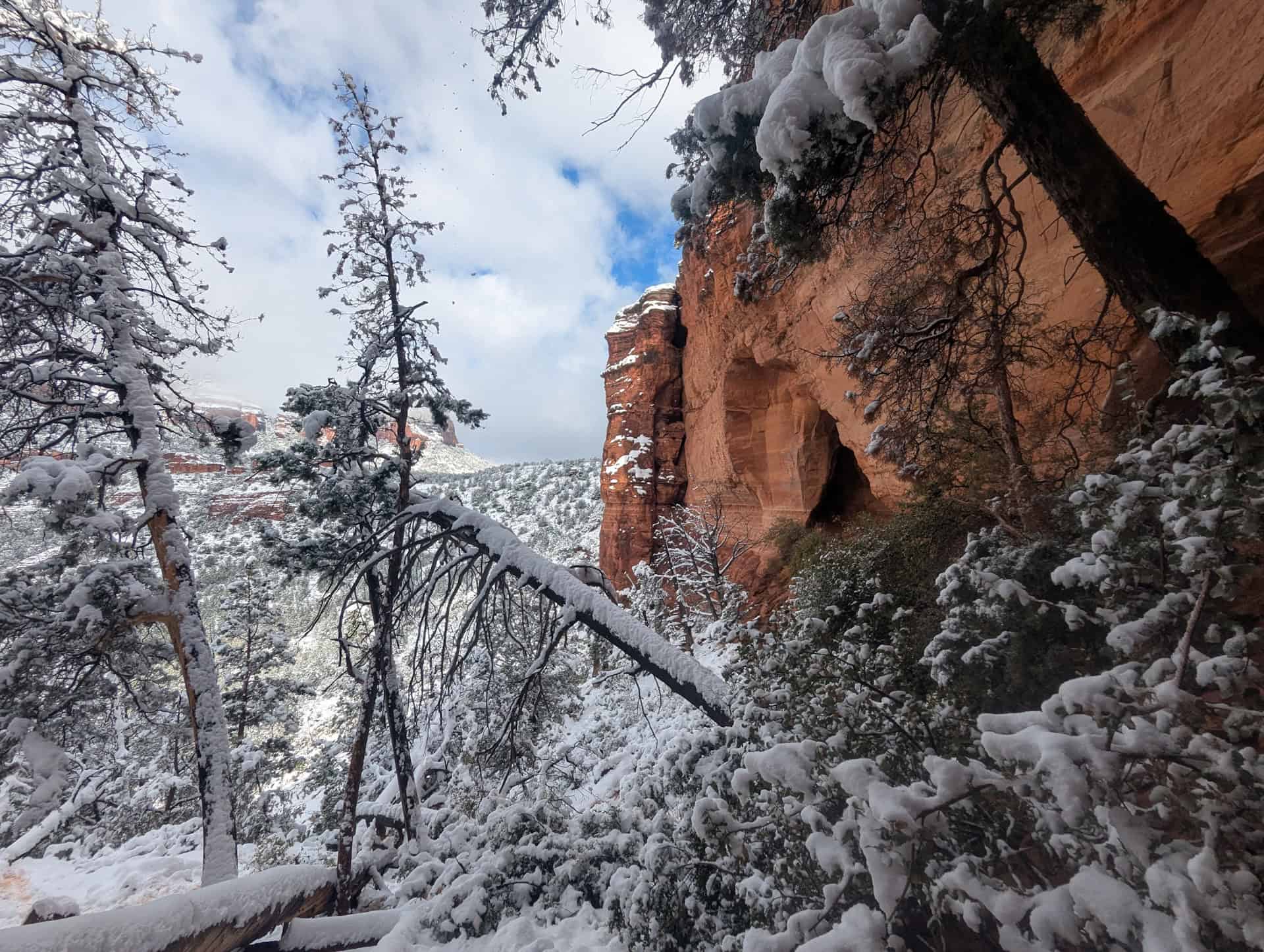
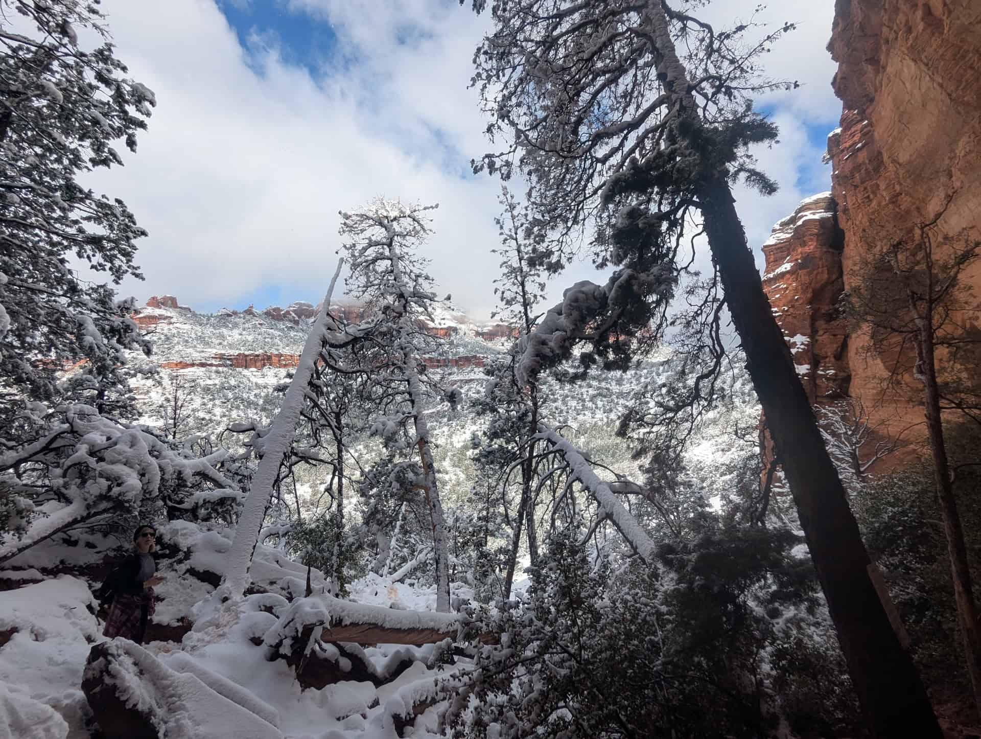
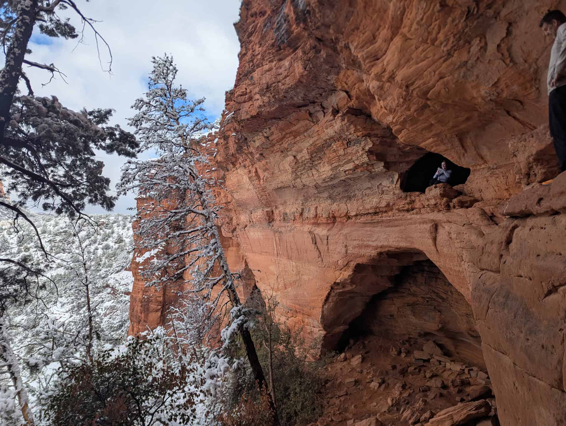
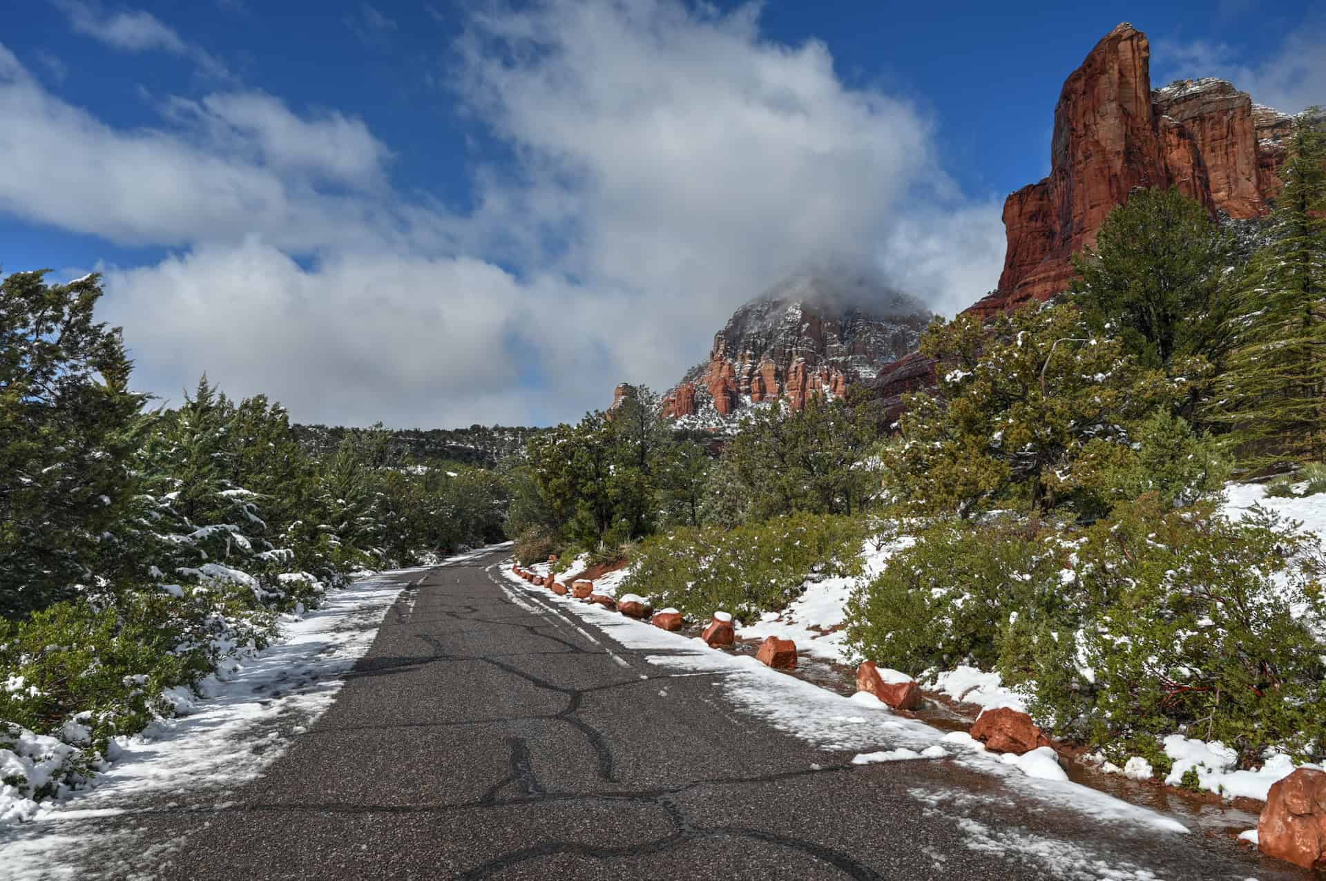
During our mid-March visit, a brief cold spell brought a rare dusting of snow to Sedona. It had snowed the night before our hike, creating a stunning contrast between the landscape’s vibrant red cliffs and bright white snow. As you can see below, the temperature rose quickly that morning, and much of the snow had melted by the time we finished the trail.


From the trailhead, the Soldier Pass Trail (Trail #66) immediately immerses you in classic Sedona scenery. The hike begins gently but wastes no time revealing its unique highlights, combining geological wonders, desert vegetation, and a touch of adventure.


Early on, you will have to cross a scenic, narrow river, but there are stepping stones along you to cross while staying dry.

Within the first half-mile, you’ll reach two of Sedona’s most famous natural landmarks: the Devil’s Kitchen Sinkhole and the Seven Sacred Pools.
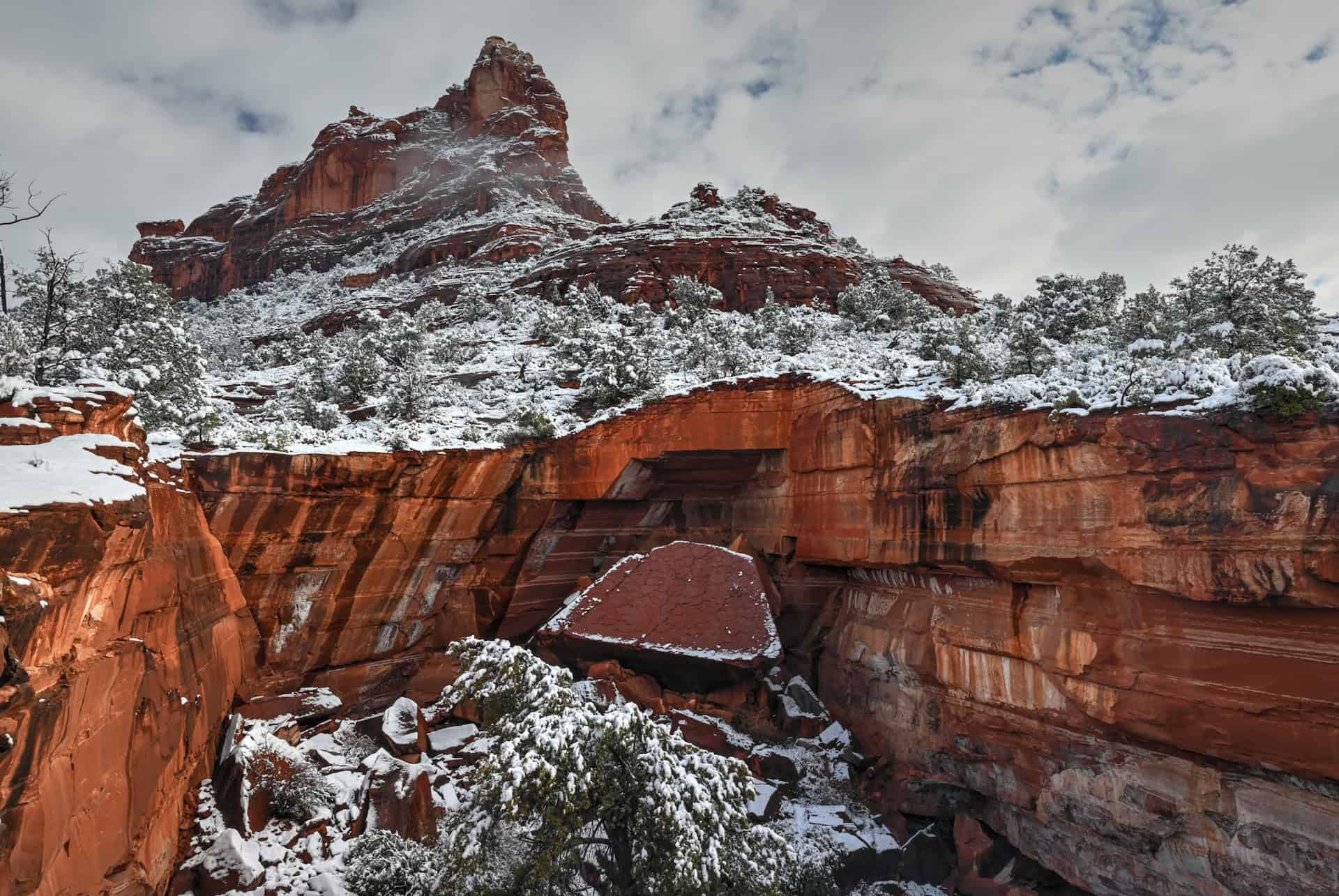
The Devil’s Kitchen Sinkhole is a dramatic sandstone collapse that formed in the early 1880s when underground caverns gave way beneath the surface. The initial collapse reportedly occurred around 1880, with a major secondary collapse in 1989 that widened the sinkhole to its current dimensions — roughly 150 feet (45 m) wide and 50 feet (15 m) deep. Occasional smaller rockfalls still occur, so it’s best to admire it from a distance rather than venturing too close to the edge.
Just a few minutes farther, you’ll arrive at the Seven Sacred Pools, one of Sedona’s most photogenic and symbolic natural features. These seven smooth rock basins were naturally carved into the sandstone by seasonal runoff flowing down from the Red Rock–Secret Mountain Wilderness. After rainfall, the pools fill with reflective water, mirroring the sky and surrounding cliffs — a favorite scene for photographers and a quiet spot for a rest before continuing the climb.
The site also holds cultural significance for Indigenous peoples of the region, including the Yavapai and Apache, who consider many water sources and natural formations in the Sedona area sacred. Visitors are encouraged to approach the Seven Sacred Pools with respect and mindfulness, avoiding wading or disturbing the water whenever possible.
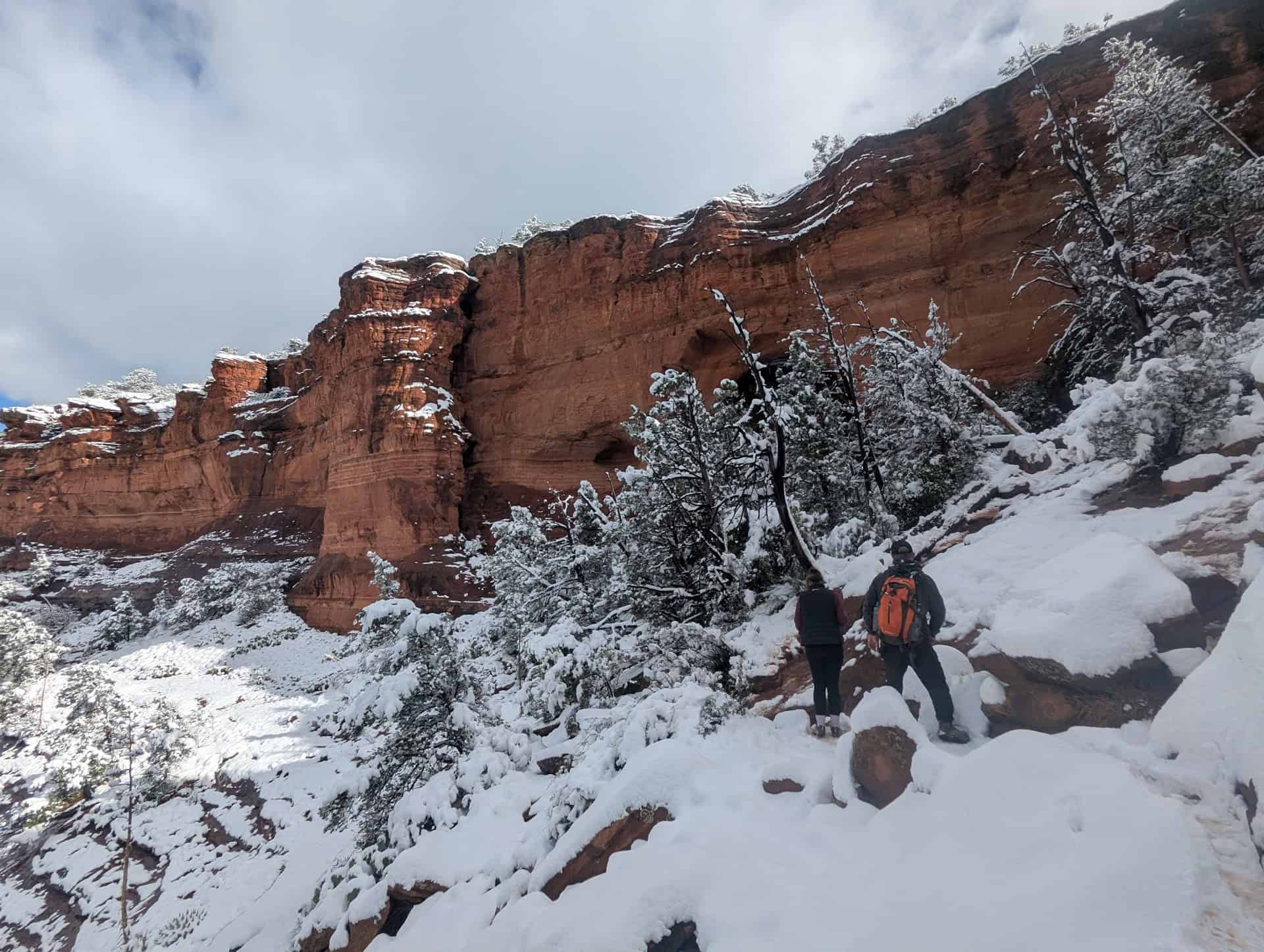
Beyond the pools, the trail gradually climbs along a sandy wash framed by red cliffs, with the landscape feeling increasingly open and expansive. After about a mile, the canyon widens into a broad, sloping mesa, offering sweeping views toward Coffee Pot Rock, Capitol Butte, and the higher ridges of the Red Rock–Secret Mountain Wilderness.
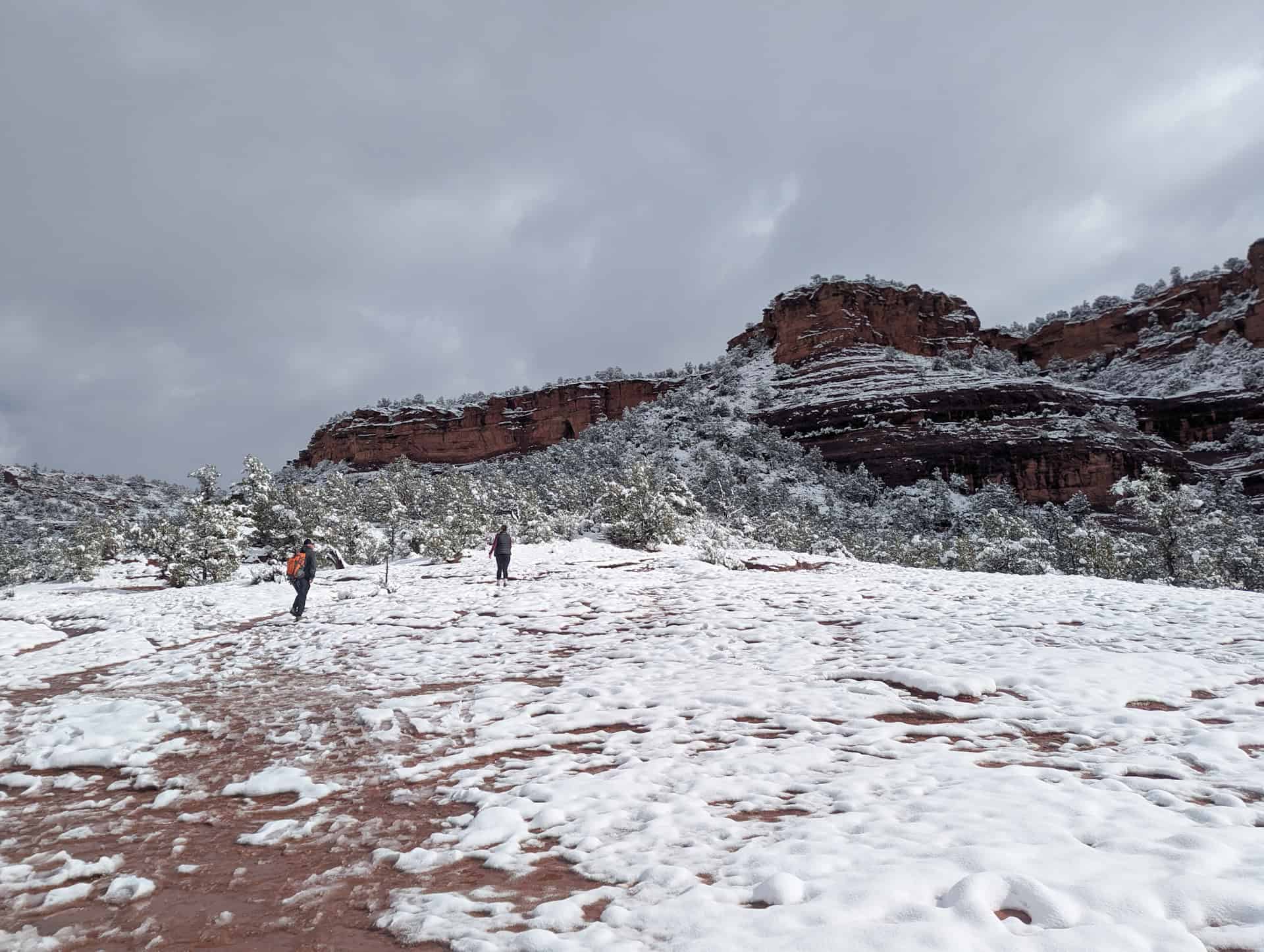
The mesa section is one of the most scenic parts of the hike — a mix of slickrock slabs and patches of sandy trail bordered by juniper and manzanita. The rock surface here can be smooth and angled, making it slippery when wet or dusty, so watch your footing, especially on the descent. Despite the exposure, the open terrain allows for nearly continuous views of Sedona’s sculpted red cliffs.


From here, the trail resumes a gentle climb before reaching the spur junction for the Soldier Pass Cave, about 1.2 miles (2 km) from the start.
The spur to the cave is unmarked but well-trodden, branching steeply to the right. This final segment is where the challenge increases — it’s a short but steep scramble over slickrock ledges and boulders. No technical climbing gear is required, but hikers should be prepared to use both hands for balance. In wet conditions, the polished rock can become slippery, so use extra caution — or skip this section if footing feels uncertain.

At the top, the trail levels out beneath a tall sandstone alcove, where a narrow opening leads into the Soldier Pass Cave itself. The cave consists of three adjoining chambers connected by arch-like openings, with natural “windows” that frame the red-rock views outside. It’s one of Sedona’s most atmospheric and photogenic spots.
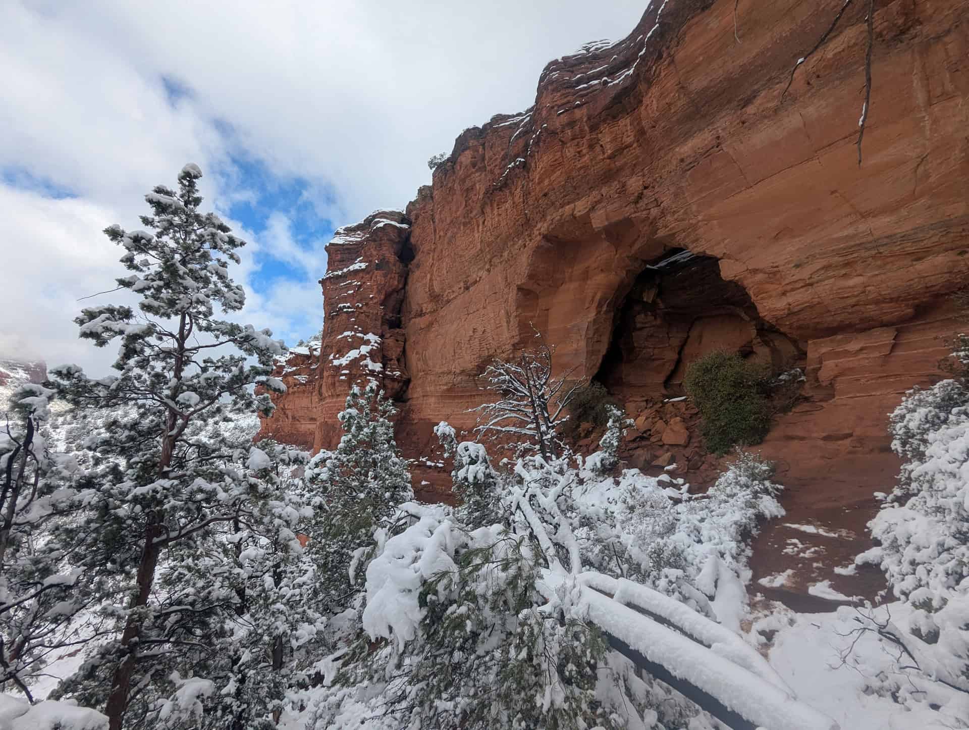
Adventurous hikers can climb through the upper chambers for stunning views framed by sandstone arches, but caution is essential as footing can be slippery and exposed.
After visiting the cave, retrace your steps back to the main trail and return the way you came. Most hikers turn around at the cave, but the trail does continue farther, connecting with the Brins Mesa Trail for those wanting a longer loop option (see further below for more information on the loop trail).
As we mentioned earlier, if you happen to miss the shuttle and still have some energy left, consider walking back to the Posse Grounds Park & Ride. The walk takes roughly the same amount of time as waiting for the next shuttle and riding it back. It’s a pleasant, albeit slightly uphill, stroll on the way there.
Overall, the Soldier Pass Trail offers an unbeatable mix of natural landmarks, scenic variety, and light scrambling. It’s one of Sedona’s most dynamic short hikes — compact yet packed with highlights, from waterfalls and sinkholes to cave exploration and sweeping red rock views.
Soldier Pass Trail Variants and Add-Ons
Continue Past the Cave (Extended Out-and-Back)
Most hikers turn around after visiting the Soldier Pass Cave, but the main trail continues beyond the cave junction. This extension climbs gradually toward the intersection with Brins Mesa Trail, offering a quieter experience through open forest and red rock views that many visitors miss. Continuing to the Brins Mesa junction (and return) leads total distance of roughly 5 miles (8 km).
Soldier Pass – Brins Mesa Loop
For a longer and more immersive adventure, consider completing the Soldier Pass–Brins Mesa Loop, one of Sedona’s most scenic moderate loops. From the Soldier Pass Trail, continue to the Brins Mesa junction, then turn right and descend Brins Mesa Trail toward the Jordan Trail, which completes the loop back to the trailhead area. Expect changing scenery — from slickrock and canyon walls to wide mesa views and forested washes. The full loop is approximately 5.7 miles (9.2 km) with around 1,100 ft (340 m) of elevation gain
Soldier Pass – Jordan Loop
A slightly shorter variant connects Soldier Pass with the Jordan Trail directly, bypassing the Brins Mesa section. This version is ideal if you want variety without committing to the full loop. You’ll still see major landmarks like the Seven Sacred Pools and Soldier Pass Cave, but with a quicker return through quieter stretches of red rock woodland. Total distance is about 3.6 miles (5.9 km).
Shorter Hike to the Seven Sacred Pools
If you’re short on time or prefer an easier walk, you can turn around at the Seven Sacred Pools for a shorter version of the trail. This out-and-back hike is roughly 1.2 miles (1.9 km) total and takes about 30–45 minutes at a relaxed pace. You’ll still experience two of Sedona’s best-known landmarks — the Pools and Devil’s Kitchen Sinkhole — without the longer climb or cave scramble.
Alternate Start: Soldier Pass via Teacup Trail
If the Soldier Pass Trailhead parking or shuttle isn’t convenient, an excellent alternative is to begin the hike from the Teacup Trailhead off Buena Vista Drive or Sugarloaf Road in West Sedona. From there, the Teacup Trail connects to Soldier Pass through a scenic network of linking paths.
This approach adds both distance and elevation gain, turning the route into a longer, more challenging half- or full-day outing, roughly 11 km (7 miles) round-trip depending on your exact route. Along the way, you’ll enjoy quieter stretches of trail, open red-rock views, and the chance to summit Sugarloaf or detour toward Coffee Pot Rock before joining the main Soldier Pass corridor.
*This route avoids the shuttle requirement but has limited parking at the Teacup Trailhead.
Soldier Pass Trail Hiking Tips
Hiking Experience
While the main trail maintains a reasonable elevation gain and is easy to follow, the spur to the cave is notably steeper and more demanding. It involves climbing over slickrock and navigating a few short, hands-on scrambles to reach the cave entrance. These sections require good traction and balance, especially on polished rock surfaces.
Overall, hikers with some prior experience on desert trails will find the route enjoyable and rewarding. Casual hikers and families with older children can comfortably explore the main trail to the Pools or Sinkhole, but those continuing to the cave should be prepared for a brief yet more technical challenge near the end.
Cell Service
Cell coverage along Soldier Pass is limited to intermittent, especially in the canyon sections and near the cave. You may get a signal near the trailhead, but do not rely on it for navigation or emergencies. Download offline maps and share your plans with someone if hiking alone.
Leave No Trace
Stay on the established trail and avoid climbing on sandstone features or scrambling near fragile rock pools. The desert ecosystem, including cryptobiotic soil and small plants, is easily damaged and can take decades to recover. Pack out all trash and minimize impact wherever possible.
Bugs
Insects are usually minimal. You might encounter gnats or flies in warmer months, particularly after rain, but mosquitoes and ticks are uncommon. Insect repellent is optional but rarely needed.
Equipment
No technical gear is required, but wear sturdy hiking shoes or boots with good traction for rocky sections and the cave approach. Bring plenty of water, sun protection (hat, sunscreen, sunglasses), and consider trekking poles for stability on uneven terrain.
Weather and Exposure
The trail is mostly exposed, with limited shade along the sandy wash and slickrock sections. Sedona’s sun can be intense year-round:
- Monsoon season (July–September): Watch for lightning and sudden flash floods, particularly in the pools and canyon areas.
- Summer: Start early (before 8 a.m.) or hike later in the afternoon to avoid peak heat.
- Winter: Cooler temperatures make for crisp, quiet hikes. Watch for icy patches on shaded rocks after frost or light snow.
Current Trail Conditions
Check the Coconino National Forest Alerts page for updates on trail conditions or temporary closures.
Wildlife
You may spot lizards basking on rocks, ravens gliding along the cliffs, and occasionally mule deer grazing in the foothills. Wildlife tends to be most active around sunrise and sunset. In warmer months, rattlesnakes and other desert reptiles are active, so keep an eye out near rocky ledges and underbrush – though they generally stay away from hikers.
Best Time to Hike the Trail
Sedona’s high desert climate means the trail can be hiked year-round, but conditions vary dramatically by season:
Spring (March–May):
One of the best times to visit. Temperatures range from 60–80°F (15–27°C), wildflowers begin to bloom, and visibility is excellent. Afternoon winds are common in March and April.
Summer (June–August):
Hot and dry, with daytime highs often above 95°F (35°C). Early morning and late evening hikes are most comfortable. Always bring extra water and watch for monsoon storms in late July through early September.
Fall (September–October):
Another ideal season. Temperatures drop back into the 70s–80s°F (21–30°C), and the light creates rich red and golden hues on the cliffs. Crowds thin out slightly after October.
Winter (November–February):
Cool, quiet, and beautiful. Highs average 50–60°F (10–16°C), with cold mornings and occasional frost on the trail. Light snow on the red rocks can make for striking photos — just watch for slick sections on shaded rock.
Quick Summary – When to Visit
For the most comfortable conditions and best lighting, spring and fall are ideal.
Summer is manageable with an early or late start and proper sun protection.
Winter offers solitude and crisp air — just dress in layers and watch for icy spots on the descent.
Hiking Packing List
All Trails subscription – This comes in really handy for areas with little or no cell reception, as the annual subscription allows you to download trail maps for offline use.
External Battery – If you are using your phone to track your progress along the trail or to help with navigation, you certainly don’t want your phone to die on you. That’s especially true in the unlikely event that you might get hurt or need assistance.
Hiking poles – These can be particularly useful in steep trails or muddy/boggy trail conditions.
Water Filter Bottle – The Life Straw bottle is an advanced water bottle with a filter that not only improves water taste but more importantly filters out bacteria and parasites, chemicals and microplastics.
Headlamp – very practical and a smart choice if you plan to start your hike before sunrise or finish it after sunset.
About Sedona & Red Rock Country
Where the Desert Meets the Pines: Nestled among Arizona’s iconic red rock formations, Sedona sits at the crossroads of desert and highland forest. Towering sandstone spires rise above juniper-covered plateaus, while oak-filled canyons hide cool streams and shaded trails. The contrast of vivid red cliffs against blue skies and green pines makes Sedona one of the most photogenic landscapes in the American Southwest.
A Landscape Shaped by Time: Sedona’s red rocks are part of the ancient Schnebly Hill Formation — layers of iron-rich sandstone sculpted by millions of years of erosion. The result is a wonderland of mesas, buttes, and cliffs that glow deep crimson at sunrise and sunset. This dramatic geology forms the heart of the Coconino National Forest and the Red Rock–Secret Mountain Wilderness, protecting hundreds of miles of hiking trails and viewpoints.
A Hub for Outdoor Adventure: From short, scenic walks to challenging summit climbs, Sedona offers hiking for every level. Iconic trails like Cathedral Rock, Devil’s Bridge, and Bell Rock draw visitors from around the world, while lesser-known routes such as Doe Mountain and Fay Canyon reveal quieter corners of the landscape. Beyond hiking, Sedona is a hub for mountain biking, jeep tours, and stargazing under some of Arizona’s clearest night skies.
A Spiritual and Cultural Destination: Long before it became a modern resort town, this region was home to the Yavapai and Apache peoples, whose history remains deeply tied to the land. Today, Sedona is also known for its vibrant arts community and its reputation as a place of renewal, with “energy vortexes” and meditation sites attracting visitors seeking connection and calm amid the red rocks.
Gateway to Northern Arizona: Located between Flagstaff and the Verde Valley, Sedona makes an ideal base for exploring the broader region — from the ancient cliff dwellings of Montezuma Castle to the scenic switchbacks of Oak Creek Canyon and the high desert plateaus beyond. Whether you’re here to hike, photograph, or simply take in the views, Sedona captures the essence of Arizona’s wild beauty.
Some of Our Other Nearby Favorite Trails
Fay Canyon Trail – Just a few minutes from the Doe Mountain Trailhead, Fay Canyon offers a gentle, shaded hike through a narrow red rock canyon framed by towering sandstone walls and desert vegetation. The main trail is easy and family-friendly, leading to a scenic alcove and a hidden natural arch near the end. For those seeking a bit more adventure, a short but steep scramble up the rocks at the canyon’s end reveals one of Sedona’s most rewarding secret viewpoints — a breathtaking panorama of the surrounding cliffs and red rock formations that few casual visitors take the time to see.


Teacup & Sugarloaf Loop – A local favorite that combines moderate climbing with panoramic views, this loop connects the Teacup and Sugarloaf trails right in the heart of Sedona. The short ascent up Sugarloaf Mountain rewards hikers with 360° views of Coffee Pot Rock, Thunder Mountain, and the greater Red Rock range.


Cathedral Rock Trail – One of Sedona’s most iconic hikes, Cathedral Rock Trail is short but steep, rewarding climbers with dramatic views and the chance to ascend directly on the sandstone fins. The trail winds through a narrow desert wash before rising sharply via well-placed rock steps and short scrambles. Those willing to tackle the final steep section are treated to an unforgettable panorama of the surrounding red rock formations, Oak Creek Valley, and distant mesas — a classic Sedona viewpoint that has become a favorite for sunrise and sunset photography. Even casual hikers can enjoy the lower portions of the trail for a taste of the vibrant sandstone scenery without committing to the full climb.
For more hiking inspiration, check out our complete guide to Sedona’s Best Hiking Trails, featuring detailed descriptions, difficulty levels, and local tips for planning your adventures.
Where to Stay Near the Soldier Pass Trail
If you’re looking for comfortable, well-located lodging in Sedona without splurging on luxury, here are four of the best mid-range options. These hotels and resorts put you within easy reach of popular hiking trails, the Red Rock Scenic Byway, and Sedona’s shops and restaurants. Most include free WiFi, parking, and convenient amenities, making them solid bases for exploring the area.
GreenTree Inn Sedona
What sets it apart: affordable comfort with a quiet, convenient location near Uptown Sedona.
Clean, well-appointed rooms, complimentary breakfast, and friendly service make this a reliable choice for hikers and families alike. Its easy access to main roads ensures a quick drive to trailheads while still offering a peaceful stay.
Hilton Grand Vacations Club – Sedona Ridge
What sets it apart: Spacious suites ideal for families or longer stays.
Featuring full kitchens, separate living areas, and a resort-style outdoor pool, this property combines convenience with extra space. Guests can enjoy easy access to nearby trails and Sedona’s scenic viewpoints, making it perfect for those who want both comfort and flexibility.
Arabella Hotel Sedona
What sets it apart: Classic mid-range hotel with a touch of style and excellent amenities.
Offering outdoor pools, on-site dining, and clean, comfortable rooms, Arabella is an easy pick for travellers seeking a balance of affordability and quality. Its central location also makes it a convenient home base for exploring both Uptown Sedona and nearby Red Rock trails.
The Wilde Resort and Spa
What sets it apart: A modern, boutique-inspired option with a spa and scenic views.
The Wilde combines well-designed rooms with amenities like a hot tub, fitness center, and easy access to nearby hiking. Ideal for those who want a bit more flair without going full luxury.
Booking Tip: Sedona lodgings can fill up quickly, particularly in spring and fall when temperatures are ideal for hiking, as well as on weekends. Early reservations are strongly recommended to secure the best rates and rooms.
Soldier Pass Trail – Frequently Asked Questions
How much time does the hike require?
Most hikers complete the out-and-back route in 1–1.5 hours, including time at the top. The mesa-top loop may add 30–45 minutes, depending on how much you explore the rim.
How difficult is the hike?
Overall, the trail is rated Moderate. Most of the hike is gentle, but rocky surfaces and short scrambles near the cave and pools require careful footing. Casual hikers may find the trail slightly challenging in these sections, while regular hikers will find it very manageable.
Are dogs allowed?
Yes, dogs are allowed on a leash. Bring water for your pet and be mindful of the exposed mesa top and rocky terrain.
Are there bathrooms along the trail?
There are vault toilets at the trailhead near the parking area. There are no facilities along the trail itself.
Do I need a permit?
Yes, a Red Rock Pass, but only if parking at the trailhead. Daily and weekly passes can be purchased at the kiosk, visitor centers, or online. Holders of an America the Beautiful Pass are exempt.
Are drones allowed?
No — drone use is prohibited in most of the Red Rock Wilderness areas, including Soldier Pass, to protect wildlife and preserve the natural experience for hikers.
Is the trail kid-friendly?
Families with older children can enjoy Soldier Pass. Keep a close eye near the cave and pools, where scrambling and uneven surfaces could be hazardous for younger kids.
Explore More Arizona
Continue exploring Arizona with these detailed travel guides:
Best Things to See and Do in Page
Monument Valley Travel Guide
Sunset Crater Volcano National Monument
Marble Canyon Guide
Photography Gear
If you like our photography, you might be interested in some of the gear we use to shoot our travel and hiking destinations.
Camera Body – Nikon Z 6ii Fx-series Mirrorless Body
Main Lens – NIKON 24-120mm F/4G ED VR AF-S
Zoom Lens – Sigma 745-306 150-600mm f/5-6.3
Polarizing filters – Urth Circular Polarizing (CPL)
Camera Tripod – K&F Concept 64-inch Camera Tripod
Mini-tripod – Lammcou Flexible Camera Tripod
Camera/hiking backpack – Vanguard Alta Rise 48 Backpack
Universal Travel Adapter – VYLEE Universal International Power Travel Plug
Other Travel Essentials
Travel Insurance
SafetyWing is a travel insurance company that offers comprehensive coverage for travellers. Includes Medical Insurance and Travel Insurance. Primarily geared towards long-term travellers, digital nomads, and expats.
e-Sim cards
Airalo is the world’s first and largest eSIM store with eSIM plans for 200+ countries and regions worldwide. With Airalo eSIMs, travellers can get connected the moment they land at their destination and avoid nasty data roaming charges
eSIMS are a sustainable alternative to single-use SIM cards – they are 100% digital, require less energy to produce and be re-used rather than disposed of.
Car Rentals
Discover Cars is our go-to website for car rentals. We almost always find our preferred rate there.
Transfer from Airport
Welcome Pickups is our favourite private transfer service, which you can pre-book at a fixed price. Currently available in 220 cities all over the world (mostly in Europe, but with several major cities in Asia, the Middle East and the US).
Kiwitaxi is another private transfer service – we haven’t tried it yet, but it’s currently available in a few more countries (102 as of 2024).
Hotels and Accommodations (coming soon)
Photography Prints
If you found this blog useful, you can help support our blog by purchasing low-cost digital prints. Printed physical prints are also available for purchase.


—–
Well, that wraps it up! We hope you enjoyed our Sedona Hiking Guide for the Soldier Pass Trail and that it will prove useful for planning your hiking trip.
—–
You might also be interested in these related pages: