Surrounded by red cliffs, sculpted sandstone, and the shimmering waters of Lake Powell, Page, Arizona, is a hiker’s paradise. While most visitors come for Horseshoe Bend or Antelope Canyon, the area offers far more than photo ops — it’s filled with short but spectacular trails that reveal hidden arches, wave-like rock formations, and sweeping desert views. Whether you’re looking for a quick stroll near town, a scenic slot canyon adventure, or a challenging climb with river views, this guide highlights the best hikes around Page.
Best Hiking Trails around Page – At a Glance
In Page
– The Beehive (New Wave) Trail
– The Hanging Garden Trail
– The Chains Trail
– The Rim Trail
– The Glen Damn Overlook Trail
– Horseshoe Bend Overlook Trail
– Antelope Canyon (guided hike through slot canyons)
Northwest of Page (towards Kanab):
– Wire Pass Slot Canyon
– Buckskin Gulch (from Wire Pass)
– The Wave (Coyote Buttes North, permit required)
– Moqui Sand Caves
Southwest of Page (Marble Canyon):
-Spencer Trail
-Glen Canyon River Trail
-Cathedral Wash Trail


Disclosure: This page (Best Hiking and Walking Trails around Page, Arizona) may contain product affiliate links. At no additional cost to you, we may receive a commission for purchases made through these links. More details can be found on our disclosure and policies page.
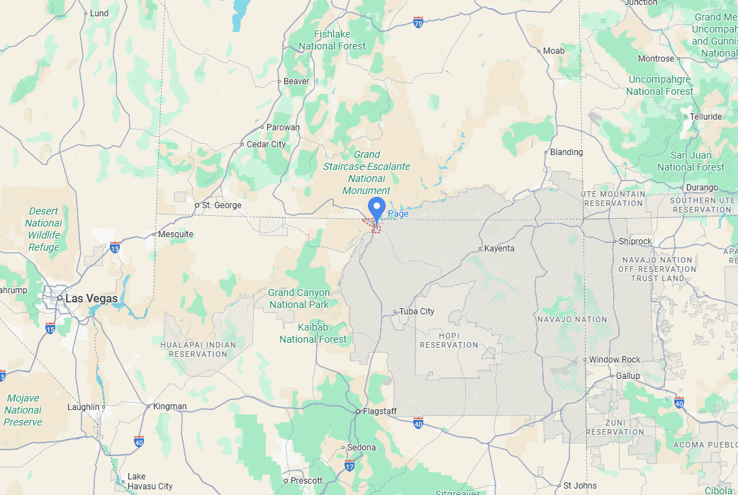
Page Location and Map
Page is located in northern Arizona (link to Google Maps), just minutes from the Utah border and at the gateway to Glen Canyon National Recreation Area. Overlooking the Colorado River and the vast waters of Lake Powell, it’s one of the most conveniently located bases for exploring the region’s natural landmarks — including Antelope Canyon, Horseshoe Bend, and Marble Canyon.
The town lies right along Highway 89, roughly halfway between the Grand Canyon’s South Rim and Zion National Park. Despite its small size, Page serves as a full-service hub for travellers, with easy access to gas, groceries, hotels, and tour operators. From downtown, most major attractions are less than a 15-minute drive away, making it an ideal stop on any Southwest road trip.
How to Get to Page, Arizona
Page is best reached by car, as there is no major airport or public transportation directly serving the town. Once in Page, there’s no reliable public transit or ride-share network, so having a car is strongly recommended.
Driving times to Page, AZ
- Las Vegas, NV: 450 km / 280 mi – about 4.5–5 hours
- Phoenix, AZ: 450 km / 280 mi – about 4.5–5 hours
- Bryce Canyon National Park, UT: 240 km / 150 mi – about 2.5–3 hours
- Flagstaff, AZ: 200 km / 125 mi – about 2.5 hours
- Kanab, UT: 120 km / 75 mi – about 1.5 hours
- Monument Valley, UT/AZ: 195 km / 120 mi – about 2 hours
These times assume good weather and minimal stops.
If you need to book a rental vehicle for your hiking excursion, we highly recommend using Discover Cars to get the best rates on your rental in Utah, Nevada and Arizona.
We also highly recommend Airalo (eSIM card) for your connectivity needs when travelling abroad. Airalo is the world’s first and largest eSIM store with eSIM plans for 200+ countries and regions worldwide.
Best Trails In Page
The Beehive (New Wave) Trail
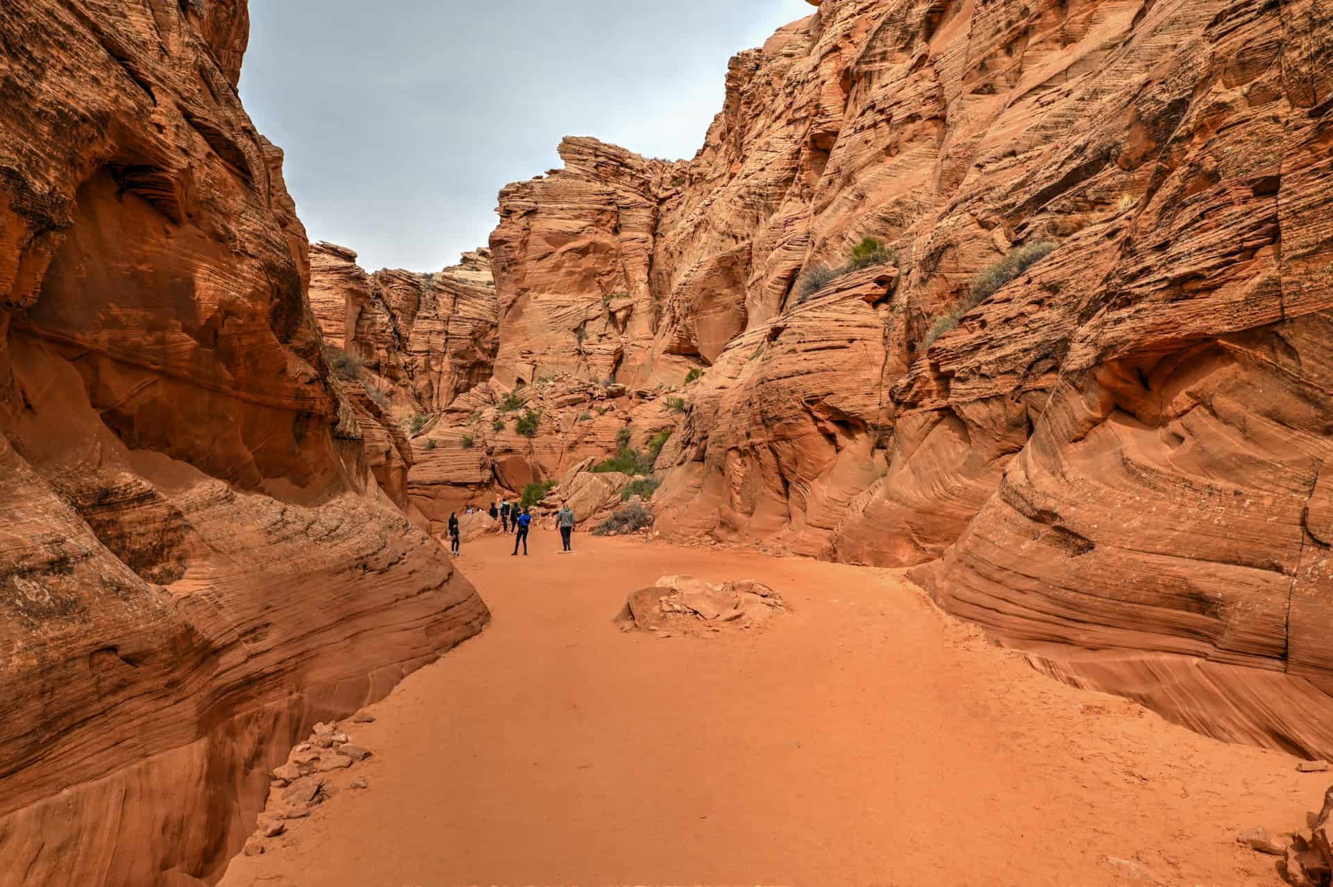
Located just beyond the Glen Canyon Dam, this short loop takes you through a maze of rounded “beehive” formations and swirling sandstone waves. It’s a compact but stunning landscape that feels like a miniature version of The Wave — without the permit. The terrain is uneven and undulating, but that’s part of the fun — you can wander freely over the slickrock, exploring curves and ridges that make every step feel like an adventure.
Distance from Page: 10-minute drive
Hike Difficulty: Easy
Trail Length: 1.3 miles (2.1 km)
Time Required: about 30-40 minutes
Cost: Free


For more details on this trail and what to expect, see our Beehive (New Wave) Hiking Guide.
The Hanging Garden Trail
A gentle, short round-trip hike leading to a lush oasis tucked beneath a sandstone overhang. The hanging garden stays cool and green even in summer, fed by groundwater seeping through the rock. Located just north of Glen Canyon Dam, it’s an easy, family-friendly trail with wide views of Lake Powell and the surrounding mesas. The route is mostly flat and straightforward, though you’ll need to climb a short, sandy slope at the end to reach the shaded alcove — a small effort well rewarded by the hidden greenery waiting inside.
Distance from Page: 5-minute drive
Hike Difficulty: Very Easy
Trail Length: 1.4 miles (2.3 km)
Time Required: 30 – 40 minutes
Cost: Free


For more details on this trail and what to expect, see our Hanging Gardens Hiking Guide.
The Chains Trail
A short but scenic route descending over smooth slickrock to the edge of Lake Powell. Despite its name, there are no actual chains — the trail takes its name from the old anchors once used to secure boats along the shore. The route isn’t formally marked, but it’s easy to follow as it weaves down the rock, with a few steeper sections that require balance and sure footing, especially as you near the lake’s shore. It’s a fun, hands-on hike that rewards you with sweeping views of the lake — a perfect spot to scramble, explore, or relax by the water.
Distance from Page: 10-minute drive
Hike Difficulty: Very easy
Trail Length: 0.4 mi (0.6 km)
Time Required: 10-20 minutes
Cost: Free


Page Rimview Trail (The Rim Trail)
Encircling the town of Page, this 10-mile (16 km) loop follows the edge of the mesa for panoramic views of Lake Powell, Glen Canyon Dam, and the red cliffs of the surrounding desert. The wide dirt path is mostly flat and easy to follow, popular with walkers, runners, and cyclists alike. You can start from several access points around town and hike shorter sections if you prefer. While it lacks shade, the open vistas and changing light make it especially beautiful near sunrise or sunset — an easy, wide-open trail that captures the vastness of Page’s desert setting.
Distance from Page: multiple access points around the town
Hike Difficulty: moderate
Trail Length: 10 mi (16 km)
Time Required: 3h30-4h for the full loop
Cost: free


The Glen Canyon Dam Overlook Trail
A quick but rewarding stop just off Highway 89, the Glen Canyon Dam Overlook offers a dramatic view of the dam and the Colorado River framed by sheer sandstone cliffs. The trail is short — only about a quarter mile round trip — but it drops steeply down a rocky staircase carved into the cliffside. A metal handrail helps with balance, though the uneven steps can be slippery in places. At the bottom, a fenced overlook provides a spectacular vantage point, especially late in the day when the canyon glows in warm desert light.
Distance from Page: 5-minute drive
Hike Difficulty: Easy
Trail Length: 0.2-mile (0.3 km)
Time Required: 5 minutes each way + time spent at overlook
Cost: Free


Horseshoe Bend Overlook Trail
One of the most famous overlooks in the American Southwest, Horseshoe Bend is an essential stop, though not necessarily for the trail itself. The 1.5-mile round-trip walk is mostly flat, wide, and sandy, with little shade or scenery along the way. It’s an easy but unremarkable approach that feels more like a stroll to an overlook than a true hike. But the payoff is extraordinary: the Colorado River sweeping in a perfect 270-degree curve, 1,000 feet below the rim. No matter how many photos you’ve seen, standing on the edge in person — especially at sunrise or sunset — is an unforgettable experience.
Distance from Page: 10-minute drive
Hike Difficulty: easy
Trail Length: 1.5 mi (2.4 km)
Time Required:
Cost: $10 for parking


For more details, see our guide for visiting Horsheshoe Bend.
Antelope Canyon (guided hike through slot canyons)
Antelope Canyon is the crown jewel of Page’s slot canyons — a winding corridor of sculpted sandstone that glows with shifting light and color. Located on Navajo land, all visits are guided, offering a respectful and informative way to explore this sacred landscape. The three most popular sections are Upper Antelope Canyon, known for its famous light beams and easy, level walk; Lower Antelope Canyon, which features ladders and narrower passages that add a touch of adventure; and Antelope Canyon X, a quieter alternative with equally beautiful formations and far fewer crowds.
Distance from Page: 10-15 minutes
Hike Difficulty: Easy for most (Moderate for Lower Antelope)
Trail Distance: between 0.5 and 1.5 miles (0.8–2.5 km)
Time Required: around 90 minutes for the guided tours
Cost: $60USD and above


We compare these three experiences in detail in our Best Things to Do in Page guide, helping you choose the one that best fits your time, budget, and mobility. For those curious about what a tour actually feels like, our Visiting Antelope Canyon X guide walks you through the full experience — from the sandy approach drive to stepping into the twisting chambers of orange and gold rock. Whether you visit the iconic Upper Canyon or the more offbeat X section, Antelope Canyon offers one of the most awe-inspiring walks anywhere in the Southwest.


Best Trails Southwest of Page (Marble Canyon):
Spencer Trail
A challenging hike that rewards effort with dramatic views of Marble Canyon and the Colorado River. Starting near the historic Lees Ferry area, the trail climbs steeply over red sandstone and loose rock, gaining about 1,500 feet in just under two miles. The route is relatively short but strenuous, with some light scrambling and uneven footing along the way. At the top, you’re treated to sweeping panoramas of the river cutting through the Vermilion Cliffs — a vantage point few visitors reach, making it a quiet and memorable adventure for those willing to tackle the climb.
Distance from Page: 1-hour drive
Hike Difficulty: Challenging
Trail Distance: 4 mi (6.4 km)
Time Required: 2h30-3h
Cost: Glen Canyon National Recreation Area Fee ($30 per vehicle – valid for 7 days)


For more details on the Spencer trail, see our Marble Canyon Visiting Guide.
Glen Canyon River Trail
A gentler version of the Spencer Trail, the Glen Canyon River Trail is a gentle, scenic trail tracing the edge of Marble Canyon along the Colorado River. This mostly flat route offers stunning views of the river winding between red sandstone cliffs and is far less strenuous than trails like Spencer. The path is wide and easy to follow, with opportunities to spot wildlife, watch riverboats drift below, and enjoy quiet stretches of desert scenery.
Distance from Page: 1-hour drive
Hike Difficulty: Easy
Trail Distance: 2.6 km (4.2 km)
Time Required: 50-60 minutes
Cost: Glen Canyon National Recreation Area Fee ($30 per vehicle – valid for 7 days)


Cathedral Wash Trail
This is a moderately challenging hike following a twisting desert wash down to the Colorado River in Marble Canyon. The trail features soft sand, slickrock, and narrow canyon sections, making footing a little tricky in places but adding to the sense of adventure. Along the way, you’ll pass dramatic red-rock walls, small alcoves, and occasional desert flora that break up the open canyon scenery. The route ends at a quiet spot along the river, where the soaring cliffs and winding water provide a rewarding payoff for the effort. Cathedral Wash is ideal for hikers looking for a longer, immersive desert experience that combines both scenic views and a touch of scrambling.
Distance from Page: 50-minute drive
Hike Difficulty: Moderate
Trail Distance: 3.3 mi (5.3 km)
Time Required: 1h30-2h
Cost: Glen Canyon National Recreation Area Fee ($30 per vehicle – valid for 7 days)


For more details on the Cathedral Wash trail, see our Marble Canyon Visiting Guide.
Best Trails Northwest of Page (towards Kanab):
Wire Pass Slot Canyon
A short but unforgettable hike through one of the most accessible slot canyons near Page. Wire Pass winds through narrow, sculpted sandstone walls that glow in warm tones as sunlight filters in from above. The trail is mostly flat and easy to follow, but features some short sections of scrambling and ladder-climbing. Starting at the trailhead in the Paria Canyon–Vermilion Cliffs Wilderness, it serves as the gateway to the longer Buckskin Gulch (see below) for those seeking a more extended desert journey. Even on its own, Wire Pass offers an amazing walk through twisting corridors and photogenic rock formations — a must-do for fans of slot canyons.
Distance from Page*: 1-hour drive
Hike Difficulty: Easy
Trail Distance: 3.5 mi (5.5 km)
Time Required: 1h30-1h45
Cost: $6 day-use fee
Important to know: a high-clearance or 4WD vehicle is strongly recommended. The trailhead is reached via House Rock Valley Road, a dirt road that can get sandy, rocky, and uneven. In dry conditions, a high-clearance 2WD might make it, but there are sections where a 4WD will make the drive much easier and reduce the risk of getting stuck.
Buckskin Gulch (from Wire Pass)
Starting from the Wire Pass trailhead, Buckskin Gulch offers one of the Southwest’s most iconic slot canyon experiences. This long, twisting corridor of narrow sandstone walls stretches for miles, with towering cliffs, occasional natural arches, and ever-changing light that creates a magical atmosphere for hikers and photographers alike. The first portion, accessible from Wire Pass, is relatively flat but requires careful footing over sand, rocks, and occasional shallow pools.
While the initial section is manageable for most (5.6 mi total, including the Wire Pass Trail), the canyon continues far beyond, offering extended exploration for experienced hikers with proper planning. The solitude and scale of Buckskin Gulch make it a striking contrast to the more heavily visited Upper and Lower Antelope Canyons, giving a sense of wandering through a hidden desert world. Because of the length and narrow passages, it’s important to check weather conditions and start early, especially to avoid flash floods in this remote wilderness area.
Distance from Page*: 1-hour drive
Hike Difficulty: Easy, but
Trail Distance (includes Wire Pass): 5.6 mi (9 km)
Time Required: 2h30-3h30
Cost: $6 day-use fee
Important to know: a high-clearance or 4WD vehicle is strongly recommended. The trailhead is reached via House Rock Valley Road, a dirt road that can get sandy, rocky, and uneven. In dry conditions, a high-clearance 2WD might make it, but there are sections where a 4WD will make the drive much easier and reduce the risk of getting stuck.
The Wave (Coyote Buttes North, permit required)
A world-famous sandstone formation on the Arizona–Utah border, The Wave is renowned for its swirling, colorful rock patterns that seem almost otherworldly. Access is tightly controlled by a permit system to protect the fragile landscape, making it a rare and highly sought-after experience. The hike to the formation runs through open desert, with sandy washes, slickrock, and minimal signage — requiring good navigation skills and preparation. Hikers face challenges from navigating the terrain, including sand and slick rock, and exposure to heat or storms.
Distance from Page*: 1-hour drive
Hike Difficulty: Moderately Challenging
Trail Distance: (10.9 km)
Time Required: 3h-4h
Cost: Permits issued by lottery only. The Wave permit has a non-refundable $9 application fee and, if successful, an additional $7 per person recreation fee.
Important to know: a high-clearance or 4WD vehicle is strongly recommended. The trailhead is reached via House Rock Valley Road, a dirt road that can get sandy, rocky, and uneven. In dry conditions, a high-clearance 2WD might make it, but there are sections where a 4WD will make the drive much easier and reduce the risk of getting stuck.
Moqui Sand Caves
A short, fun, and slightly adventurous hike leading to a series of hidden sandstone caves carved into the cliffs above Highway 89. The trail is mostly flat until the final section, where a short stretch of light scrambling over rock ledges leads to the cave openings, including a steep ascent that requires using a rope anchored to the rock. Once inside, you’ll find cool, shaded alcoves and natural rock formations perfect for exploring and taking unique photos. Easy to reach from Page, this trail offers a playful, hands-on adventure that contrasts nicely with the region’s slot canyons and overlooks.


Distance from Page: 1h15
Hike Difficulty: Moderate (mostly easy, but with a slightly challenging section)
Trail Length: 1.2 mi (2 km)
Time Required: 30-40 minutes
Cost: Free
For more details and information on the caves and the trail that leads to them, see our Moqui Sand Caves Hiking Guide.
Tips and Tricks for Hiking Around Page
Hiking in the Page area is incredibly rewarding, but a few practical considerations can make your adventures safer and more enjoyable.
Sun and Heat Exposure – The desert sun can be intense, especially from late spring through early fall. Trails offer little to no shade, so bring a hat, sunglasses, sunscreen, and plenty of water. Lightweight, breathable clothing will help you stay cool during longer hikes. Early morning and late afternoon hikes are ideal for cooler temperatures and softer light for photography.
Flash Floods – Slot canyons like Antelope, Buckskin Gulch, and Wire Pass are prone to sudden flash floods, even if storms are miles away. Always check the weather forecast before entering narrow canyons, and avoid hiking in washes if rain is expected. Be aware of escape routes and keep a close eye on the sky for rapidly changing conditions.
Cell Service – Coverage can be spotty or nonexistent in many canyon areas, including Marble Canyon and more remote trailheads. Cell coverage can be unreliable—download offline maps and directions in advance (e.g., from AllTrails) before heading out.
Not an AllTrails member yet? We highly recommend signing up for either their free or paid membership plans. The free plan allows you to find new trails and plan routes but it can only be used while hiking if you have access to mobile data. The paid membership plan (AllTrails+) allows you to download trail maps for offline use and provides live progress updates and off-route notifications.
If you are still uncertain – you should know that the All Trails mobile application was voted the 2023 iPhone App of the Year by Apple.
We find that AllTrails is a great tool to have when hiking, particularly for assisting with navigation when the trail is hard to locate and to help monitor your progress along the trail, which helps estimate how much time you’ll need to complete the trail.
Temperature and Seasons – Spring (March–May) and fall (September–November) offer the most comfortable temperatures for hiking. Summer can be extremely hot, with daytime highs often exceeding 100°F (38°C). Winter brings cooler temperatures and occasional snow on higher elevations, but can also offer quiet trails and dramatic contrasts in the desert landscape.
Other Tips :
- Footwear: Sturdy hiking shoes or boots with good traction are recommended, especially for slickrock and uneven terrain.
- Timing: Arrive early at popular trailheads to avoid crowds, especially at Horseshoe Bend, Antelope Canyon, and The Wave.
- Leave No Trace: Respect the fragile desert environment. Pack out all trash and avoid stepping on delicate vegetation or sandstone formations.
- Hydration: Even shorter hikes can be surprisingly demanding in the desert heat. Carry enough water for at least 1–2 liters per hour of activity.
Hiking Packing List
All Trails subscription – This comes in really handy for areas with little or no cell reception, as the annual subscription allows you to download trail maps for offline use.
External Battery – If you are using your phone to track your progress along the trail or to help with navigation, you certainly don’t want your phone to die on you. That’s especially true in the unlikely event that you might get hurt or need assistance.
Hiking poles – These can be particularly useful in steep trails or muddy/boggy trail conditions.
Water Filter Bottle – The Life Straw bottle is an advanced water bottle with a filter that not only improves water taste but more importantly filters out bacteria and parasites, chemicals and microplastics.
Headlamp – very practical and a smart choice if you plan to start your hike before sunrise or finish it after sunset.
Where to Stay in Page
If you’re looking for comfortable, well-located lodging in Page without splurging on luxury, here are four of the best mid-range options in town. These hotels are all within easy reach of major attractions, including Horseshoe Bend, Antelope Canyon, and Lake Powell. All include free parking, free WiFi, and breakfast, making them solid bases for exploring the region.
Best Western Plus at Lake Powell
What sets it apart: Its walkable downtown location, near restaurants and shops.
A reliable and comfortable choice featuring hot breakfast, a seasonal outdoor pool and hot tub, and clean, spacious rooms. Ideal if you want to leave the car behind in the evenings.
Hyatt Place Page Lake Powell
What sets it apart: Newer and more modern than many competitors in town.
Contemporary rooms with separate sitting areas, plus amenities like a gym, bar/lounge, and outdoor pool. A great pick for families or those wanting a slightly elevated mid-range stay.
La Quinta Inn & Suites by Wyndham Page at Lake Powell
What sets it apart: Pet-friendly rooms with practical in-room amenities.
Offers hot breakfast, an outdoor pool, and guest rooms with a microwave and refrigerator—especially convenient for longer stays or travellers bringing a pet.
Wingate by Wyndham Page Lake Powell
What sets it apart: Excellent value with consistently high guest satisfaction.
Features an indoor pool and spa, fitness center, and comfortable modern rooms.
Booking Tip: Lodging near Page can fill up fast — especially during peak seasons (spring & fall) and weekends. Reserve early.
Explore More Arizona
Continue exploring Arizona with these detailed travel guides:
Best Things to See and Do in Sedona
Best Stops and Must-See Attractions Between Las Vegas and Sedona
Monument Valley Travel Guide
Sunset Crater Volcano National Monument
Photography Gear
If you like our photography, you might be interested in some of the gear we use to shoot our travel and hiking destinations.
Camera Body – Nikon Z 6ii Fx-series Mirrorless Body
Main Lens – NIKON 24-120mm F/4G ED VR AF-S
Zoom Lens – Sigma 745-306 150-600mm f/5-6.3
Polarizing filters – Urth Circular Polarizing (CPL)
Camera Tripod – K&F Concept 64-inch Camera Tripod
Mini-tripod – Lammcou Flexible Camera Tripod
Camera/hiking backpack – Vanguard Alta Rise 48 Backpack
Universal Travel Adapter – VYLEE Universal International Power Travel Plug
Other Travel Essentials
Travel Insurance
SafetyWing is a travel insurance company that offers comprehensive coverage for travellers. Includes Medical Insurance and Travel Insurance. Primarily geared towards long-term travellers, digital nomads, and expats.
e-Sim cards
Airalo is the world’s first and largest eSIM store with eSIM plans for 200+ countries and regions worldwide. With Airalo eSIMs, travellers can get connected the moment they land at their destination and avoid nasty data roaming charges
eSIMS are a sustainable alternative to single-use SIM cards – they are 100% digital, require less energy to produce and be re-used rather than disposed of.
Car Rentals
Discover Cars is our go-to website for car rentals. We almost always find our preferred rate there.
Transfer from Airport
Welcome Pickups is our favourite private transfer service, which you can pre-book at a fixed price. Currently available in 220 cities all over the world (mostly in Europe, but with several major cities in Asia, the Middle East and the US).
Kiwitaxi is another private transfer service – we haven’t tried it yet, but it’s currently available in a few more countries (102 as of 2024).
Hotels and Accommodations (coming soon)
Photography Prints
If you found this blog useful, you can help support our blog by purchasing low-cost digital prints. Printed physical prints are also available for purchase.


—–
Well, that wraps it up! We hope you enjoyed our Travel Guide on the Best Hiking and Walking Trails around Page, Arizona and that it will prove useful for planning your trip.
—–
You might also be interested in these related pages: