Southern Utah is one of the best regions in the U.S. for hiking, with an unusually high concentration of trails spread across several national parks and surrounding desert landscapes. Within a relatively small area of the state, you can hike through narrow slot canyons, walk along exposed slickrock, stand beneath massive sandstone arches, and follow the edges of deep canyon systems carved by the Colorado and Green Rivers.
This guide highlights 15 of the most worthwhile hikes across southern Utah, including trails in Zion National Park and Bryce Canyon National Park, around Moab (including Arches National Park and Canyonlands National Park), Capitol Reef National Park, and Monument Valley. Because there are so many options, choosing where to spend your time can quickly become overwhelming, especially if you’re visiting multiple parks in a single trip.
The focus here is on hikes that, in our view, stand out for their scenery, uniqueness, or overall experience, and all of which have strong effort-to-reward ratios.
Southern Utah Hiking Highlights – At a Glance
High concentration of top-tier hikes – Several of the best hiking areas in the U.S. are located within a few hours of each other.
Wide range of terrain and unique landscapes – Includes slickrock, canyon rims, desert trails, hoodoos, and river corridors.
Mix of short and longer hikes – Many of the most rewarding trails can be completed in under 2 hours, while others offer more extended routes.
Includes trails from each of the Big 5 – The list spans Zion National Park, Bryce Canyon National Park, Capitol Reef National Park, Arches National Park, and Canyonlands National Park.
Strong seasonal considerations – Spring and fall generally offer the best hiking conditions, while summer heat can significantly impact exposed trails.


Disclosure: This page (15 Must-Do Hiking Trails in Southern Utah) may contain product affiliate links. At no additional cost to you, we may receive a commission for purchases made through these links. More details can be found on our disclosure and policies page.
Short trails (easy to moderate difficulty) (under 2 hours)
1. Hickman Bridge Trail
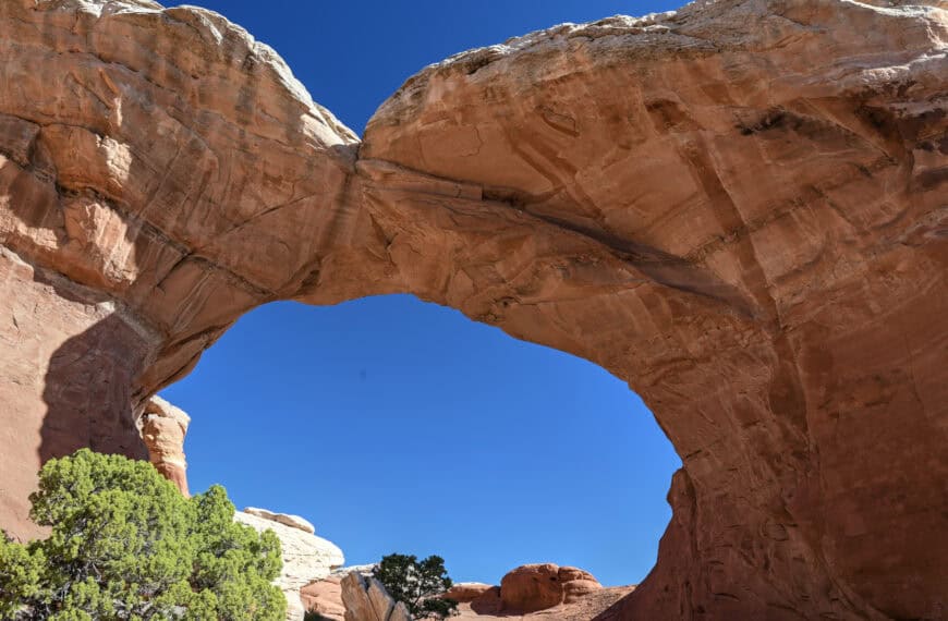
The Hickman Bridge Trail is one of the best short hikes in Capitol Reef National Park, leading to a large natural bridge set within a quiet canyon landscape. The trail climbs gradually from the Fremont River area, passing through a mix of desert terrain and rock formations before reaching the bridge.
Compared to many hikes in southern Utah, the setting here feels more enclosed, with canyon walls and rock layers creating a different atmosphere from the more open slickrock environments found in places like Moab. The final section opens up beneath Hickman Bridge, where you can walk directly underneath the span and explore the surrounding area.


Why it’s a great hike:
This is one of the most accessible ways to experience a large natural bridge up close. The trail offers a good balance of variety of scenery and effort level.
Notable highlight: Walking directly beneath a large natural bridge
Location: Capitol Reef National Park
Trail difficulty: Easy to moderate (short climb with noticeable elevation gain)
Typical hike duration: 1h-1h15
Trail fee: Included with Capitol Reef National Park entry
Potential drawback: Parking is small and can fill up quickly on busy days.
For detailed trail information, route descriptions, and photos, see our Hickman Bridge Hiking Guide.
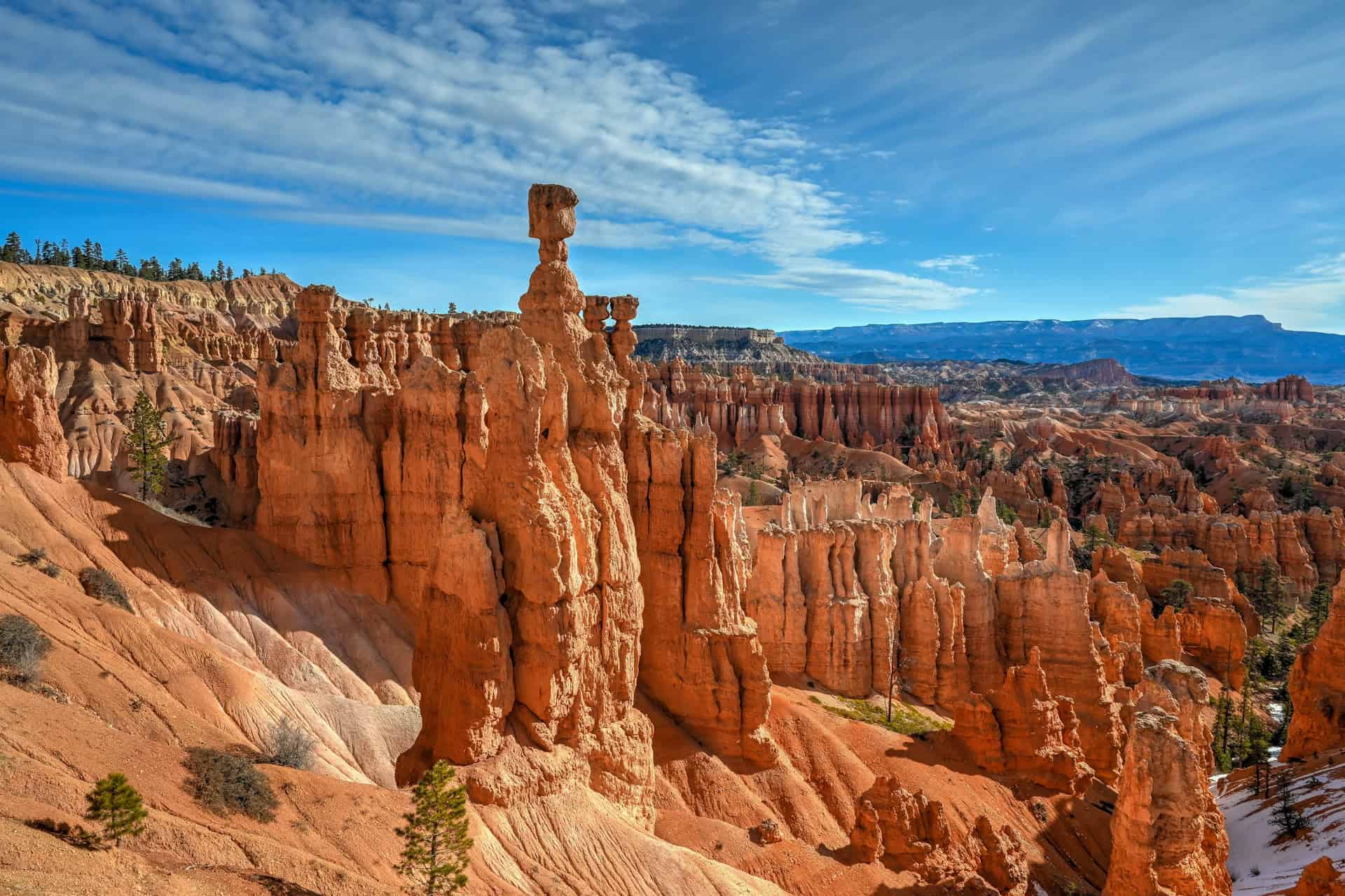
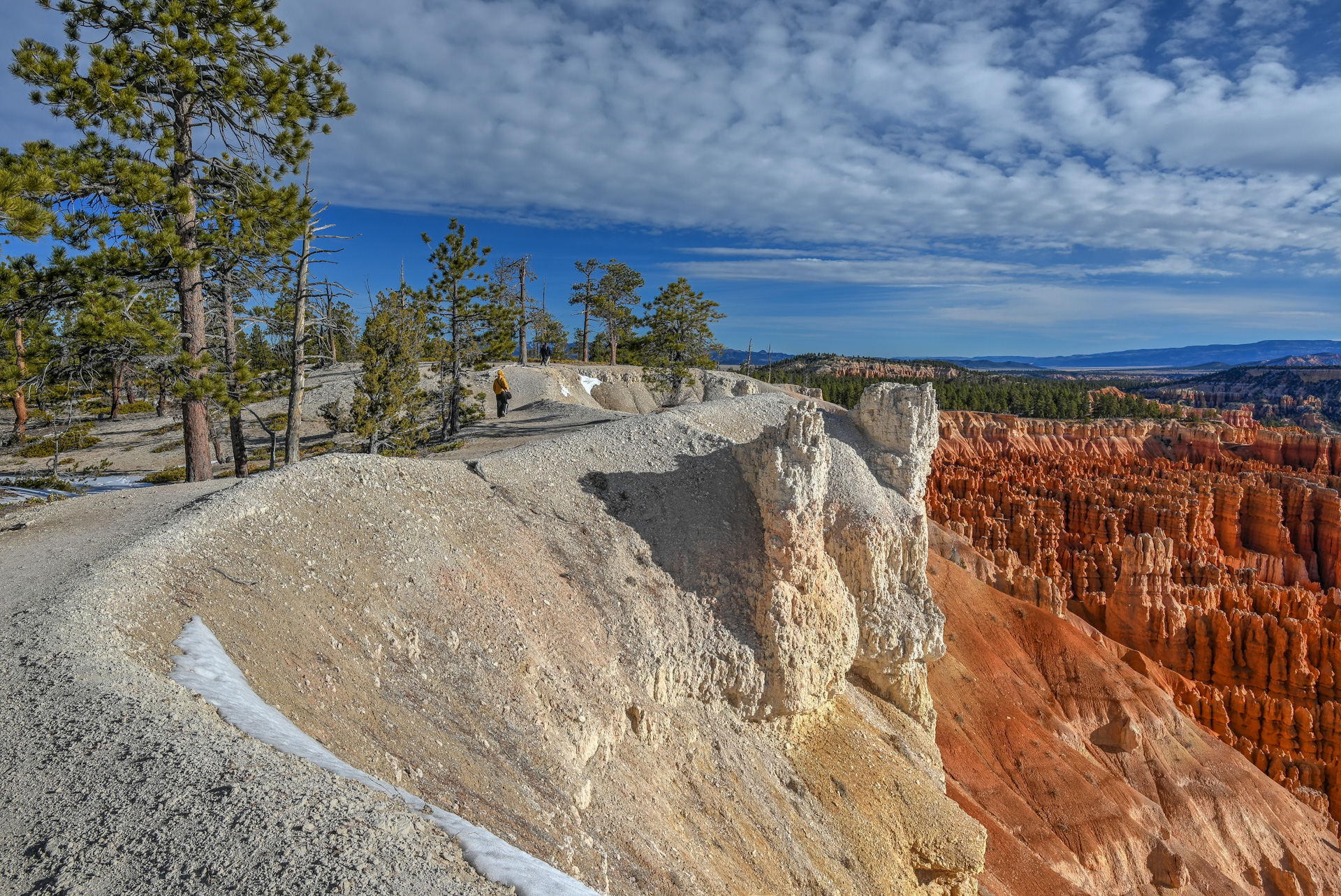
2. Navajo Loop & Queen’s Garden Trail
The Navajo Loop & Queen’s Garden Trail is one of the most complete hikes in Bryce Canyon National Park, combining the park’s most iconic scenery into a single loop. The route descends from the rim into the Bryce Amphitheater, where a dense concentration of hoodoos rises from the canyon floor.
The trail passes through narrow switchbacks, rock formations, and open sections within the amphitheater before climbing back up to the rim. Along the way, you’ll move through some of the most recognizable areas in Bryce, including formations like Thor’s Hammer and the Queen’s Garden.


Why it’s a great hike:
This is one of the best ways to experience Bryce Canyon beyond the viewpoints. The loop takes you down into the hoodoos rather than just looking at them from above, offering a much more immersive and varied experience.
Notable highlight: Walking among dense clusters of hoodoos inside the Bryce Amphitheater
Location: Bryce Canyon National Park
Trail difficulty: Moderate (steep switchbacks on the return climb)
Typical hike duration: 1.5–2. hours
Trail fee: Included with Bryce Canyon National Park entry
Potential drawback: Steep switchbacks can feel demanding, especially on the climb back to the rim.
For detailed trail information, route descriptions, and photos, see our Navajo Loop & Queen’s Garden Hiking Guide.
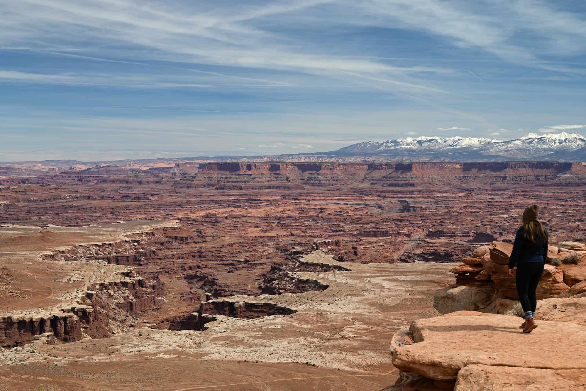
3. White Rim Overlook Trail
The White Rim Overlook Trail is one of the best short hikes in the Island in the Sky district of Canyonlands National Park, leading to a viewpoint that looks directly down onto the canyon below.
The trail begins on open desert terrain before gradually descending across slickrock toward the edge of the mesa. Unlike some viewpoints visible from the road, this one requires a bit of walking to reach, which helps create a quieter, more immersive experience. That said, the views are also quite spectacular throughout the trail.
As you approach the end of the trail, the landscape opens up, revealing the White Rim sandstone bench and the Colorado River canyon far below.


Why it’s a great hike:
The views and scenery are spectacular, and the trail is surprisingly quiet (fewer crowds) compared to other Canyonland trails.
Notable highlight: Elevated viewpoint looking directly down onto the White Rim and canyon below, beautifully backdropped by the La Sal mountains.
Location: Canyonlands National Park (Island in the Sky)
Trail difficulty: Easy (mostly flat with a gentle descent)
Typical hike duration: 45 minutes – 1 hour
Trail fee: Included with Canyonlands National Park entry
For detailed trail information, route descriptions, and photos, see our White Rim Overlook Trail Guide.
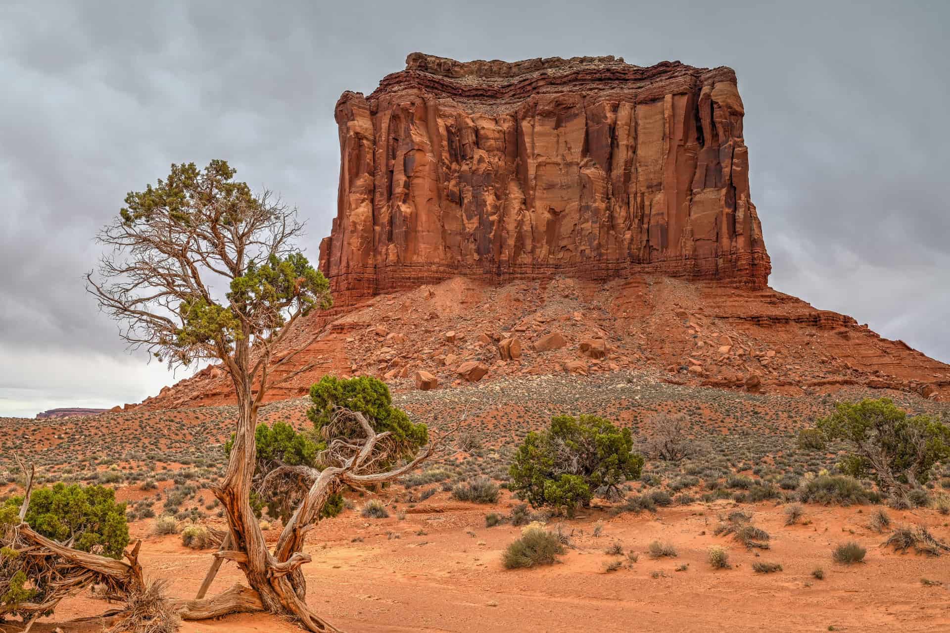
4. Wildcat Trail
The Wildcat Trail is one of the few true hiking trails in Monument Valley, offering a rare opportunity to explore the landscape on foot rather than from roadside viewpoints.
The trail forms a loop around West Mitten Butte, passing through open desert terrain with wide views of the surrounding mesas and iconic sandstone formations. Unlike the more developed parks in southern Utah, the setting here feels more remote and less structured, with fewer trail markers and a stronger sense of open space.
Because it stays on relatively flat terrain, the hike is more about the surrounding scenery than elevation or technical challenge.


Why it’s a great hike:
This is one of the only ways to experience Monument Valley beyond the viewpoints, allowing you to walk directly through the landscape and see the formations from changing perspectives.
Notable highlight: Walking at the base of the iconic mitten-shaped buttes
Location: Monument Valley
Trail difficulty: Easy
Typical hike duration: 1h30 -2h
Trail fee: Included with Monument Valley entry
Potential drawback: Trail is quite sandy over several stretches, making footing a little more difficult
For detailed trail information, route descriptions, and photos, see our Wildcat Trail Guide.
5. The Rim Trail (Bryce Canyon- amphitheater section)
The Rim Trail in Bryce Canyon National Park is one of the most accessible ways to experience the park’s amphitheater from above. Instead of descending into the hoodoos, this trail follows the edge of the canyon. While the full Rim Trail is rather long and somewhat challenging, the one-mile stretch connecting the park’s main amphitheater viewpoints is mostly flat, well-maintained, and easy to follow.
The perspective from the rim highlights the scale and density of the hoodoos, with changing light throughout the day altering the colors and contrast of the formations.


Why it’s a great hike:
This is one of the easiest ways to get sustained views of Bryce Canyon without a major climb. It works well as a standalone walk or combined with other trails like Navajo Loop.
Notable highlight: Continuous views over the Bryce Amphitheater from the rim
Location: Bryce Canyon National Park
Trail difficulty: Very Easy
Typical hike duration (amphitheater section only): 45-60 minutes
Trail fee: Included with Bryce Canyon National Park entry
Potential drawback: can be more crowded than the park’s other trails, particularly around the viewpoints.
For detailed trail information, route descriptions, and photos, see our Bryce Canyon Rim Trail Guide.
6. Corona Arch & Pinto Arch
The Corona Arch & Pinto Arch Trail is one of the best hikes near Moab, located on BLM land along the Colorado River. The route follows a mix of desert terrain and slickrock, leading to one of the largest freestanding arches in the region.
The trail first climbs steadily to a slickrock plateau, where a junction allows you to detour toward Pinto Arch or continue toward Corona Arch. Along the way, the route includes a short ladder and cable section, adding some variety to the hike without requiring technical skills.
Corona Arch is the main highlight, with a massive span that rivals many arches found in Arches National Park. Pinto Arch, while smaller, offers a quieter detour with elevated views over the Colorado River corridor.


Why it’s a great hike:
This hike combines a large, impressive arch with a more varied route than most short desert trails (including a short and relatively easy cable-and-ladder section). The option to include Pinto Arch also adds flexibility without significantly increasing difficulty.
Notable highlight: Standing beneath one of the largest arches in the Moab area
Location: Near Moab (Colorado River Scenic Byway, UT-279)
Trail difficulty: Moderate (short climbs, slickrock, ladder section)
Typical hike duration: 1h30-2h
Trail fee: Free (BLM land)
Potential drawback: The ladder/cable section may feel intimidating to novice hikers.
For detailed trail information, route descriptions, and photos, see our Corona Arch & Pinto Arch Hiking Guide.
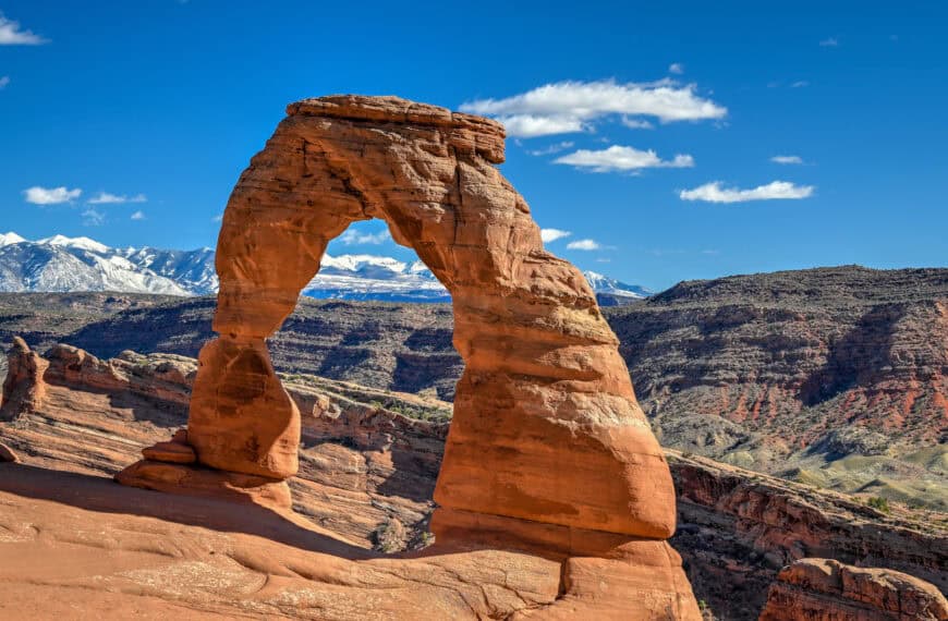
7. Delicate Arch Trail
Few hikes in southern Utah are as recognizable as the trail to Delicate Arch. Located in Arches National Park, this route climbs steadily across open slickrock before reaching a massive freestanding arch set against the distant La Sal Mountains.
Unlike many arches in the park that can be viewed from roadside pullouts or short walks, reaching Delicate Arch requires a sustained climb, which makes the final approach feel more rewarding. As you round the last bend, the arch comes into view framed by open desert and distant peaks, a perspective that has become one of the most iconic images of the American Southwest.


Why it’s a great hike:
The combination of a steady climb, open slickrock terrain, and a dramatic final reveal makes this one of the most rewarding hikes in the region. The setting around the arch is wide and open, giving it a sense of scale that’s hard to match elsewhere in Arches.
Notable highlight: One of the most photogenic arches in Southern Utah
Location: Arches National Park
Trail difficulty: Moderate (steady elevation gain across exposed slickrock)
Typical hike duration: 1h30–2h
Trail fee: Included with Arches National Park entry
Potential drawback: Crowds can be significant, especially near sunset.
For a detailed breakdown of trail conditions and the best time of day to hike, see our full Delicate Arch Hiking Guide.
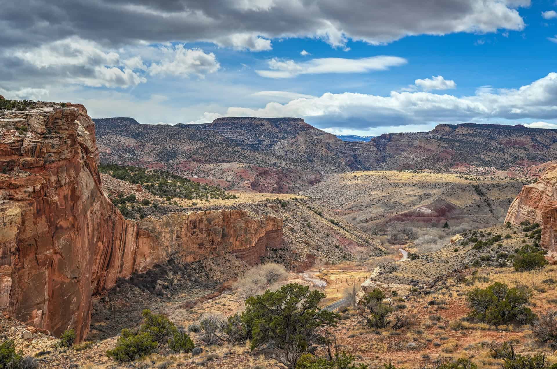
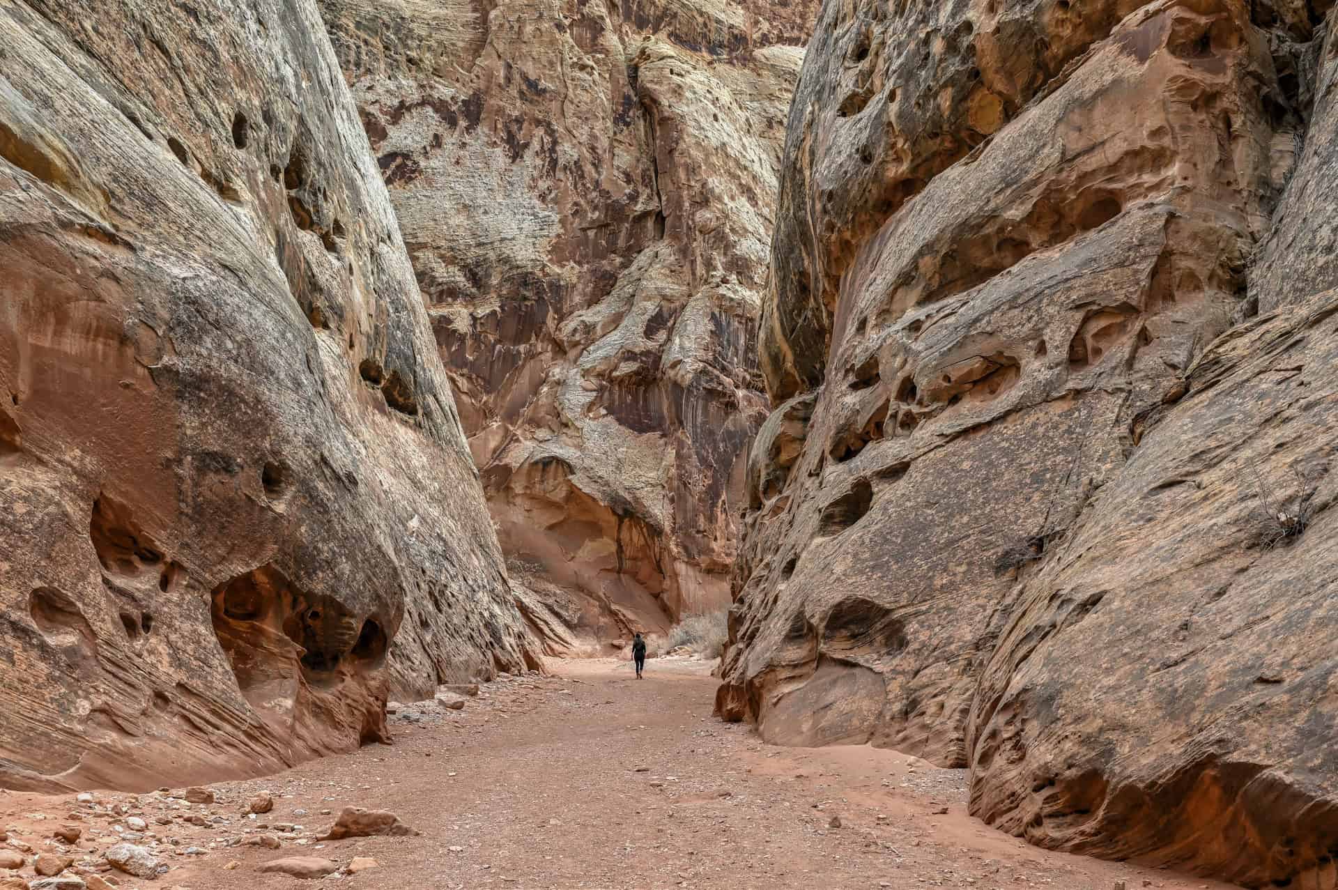
8. Grand Wash
The Grand Wash Trail follows a wide, dry wash that gradually narrows into a more defined canyon. Unlike hikes that focus on a single viewpoint or destination, this route is more about the setting itself, with towering rock walls rising on both sides as you move deeper into the canyon.
The terrain is mostly flat and sandy, making it an easy walk, but the changing scale of the canyon keeps the hike interesting throughout. In some sections, the walls close in to form a narrower corridor, giving the trail a more enclosed and immersive feel compared to the open landscapes found elsewhere in southern Utah.


Why it’s a great hike:
This is one of the easiest ways to experience a canyon setting up close, with minimal elevation gain and a constantly evolving landscape.
Notable highlight: Walking through a narrowing canyon with towering rock walls
Location: Capitol Reef National Park
Trail difficulty: Easy (mostly flat, occasionally sandy terrain)
Typical hike duration: 1–2 hours (depending on turnaround point)
Trail fee: Included with Capitol Reef National Park entry
Potential drawback: Less of a single “wow” viewpoint compared to other hikes in the list.
For detailed trail information, route descriptions, and photos, see our Grand Wash Trail Guide.
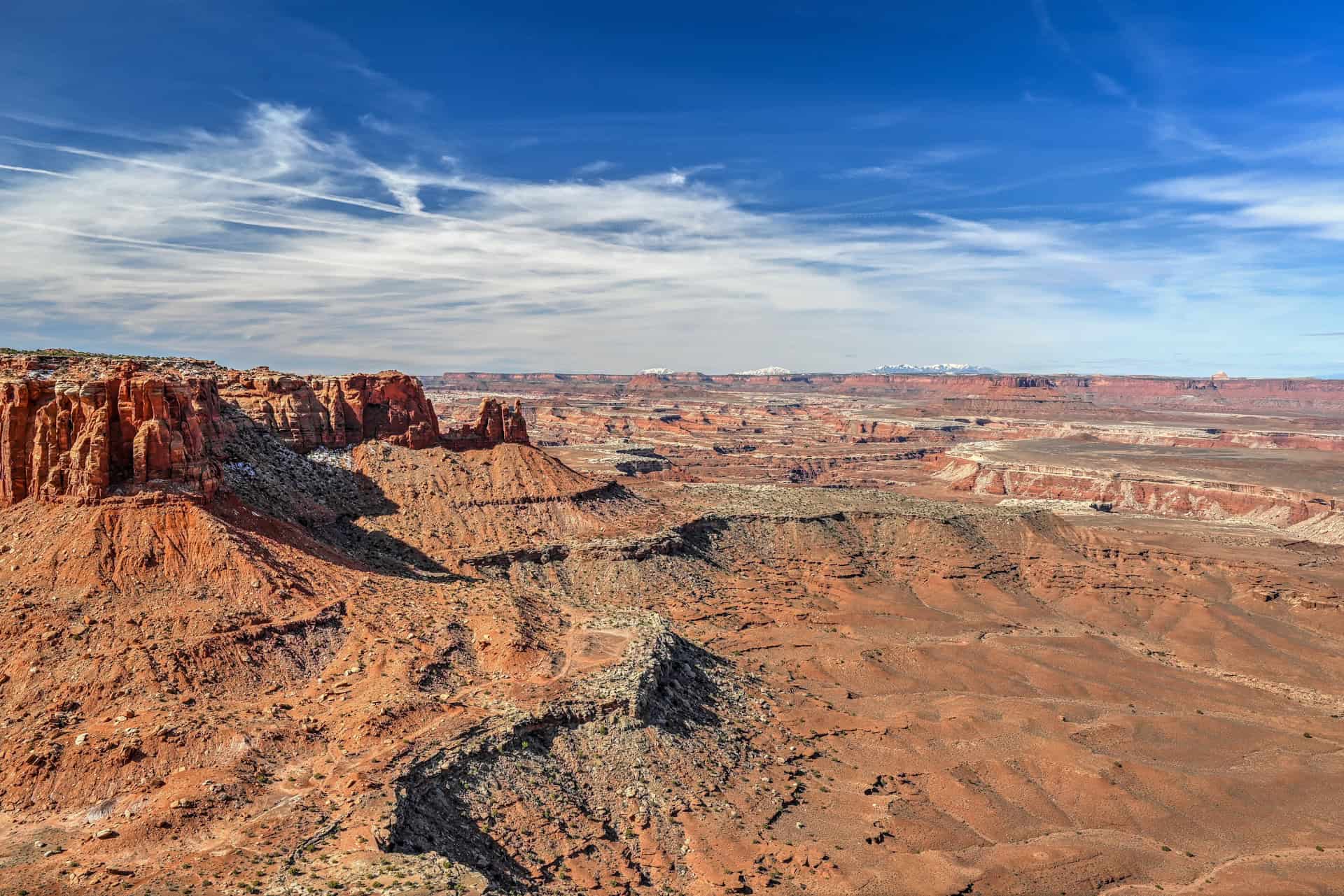
9. Grand View Point Trail
The Grand View Point Trail follows the edge of a narrow mesa in the Island in the Sky district of Canyonlands National Park, offering continuous views across one of the largest canyon landscapes in the Southwest.
From the start, the trail runs along the rim, alternating between open viewpoints and slightly more sheltered sections inland. As you continue, the perspectives expand, revealing layers of canyons carved by the Colorado River, the White Rim below, and distant mesas stretching across the horizon.
Unlike shorter viewpoint stops, this trail rewards hikers who continue to the end, where the views feel more expansive and less crowded than at the main overlook.


Why it’s a great hike:
This is one of the few trails where the views are constant rather than concentrated in a single spot. Walking along the rim provides a more complete and immersive experience of the canyon landscape.
Notable highlight: Continuous rim-side views over the canyon system
Location: Canyonlands National Park (Island in the Sky)
Trail difficulty: Easy (mostly flat with minor elevation changes)
Typical hike duration: 45-60 minutes
Trail fee: Included with Canyonlands National Park entry
For detailed trail information, route descriptions, and photos, see our Grand View Point Trail Guide.
10. Watchman Trail
The Watchman Trail is one of the most convenient hikes in Zion National Park, starting near the visitor center and climbing to a viewpoint overlooking the lower canyon.
The trail follows a well-defined path with a steady but manageable ascent, moving through open desert terrain and low vegetation. As you gain elevation, the views open up across the canyon, with the Virgin River, the town of Springdale, and surrounding cliffs coming into view.
Because of its location near the park entrance, this hike is easy to fit into an arrival or departure day, making it one of the most flexible options in Zion.


Why it’s a great hike:
This is one of the best short hikes in Zion for a quick overview of the canyon without relying on the shuttle system. The steady climb delivers a rewarding viewpoint with relatively little time commitment.
Notable highlight: Elevated views over Zion Canyon and Springdale
Location: Zion National Park (near the visitor center)
Trail difficulty: Moderate (steady uphill climb)
Typical hike duration: 1h30-2h
Trail fee: Included with Zion National Park entry
Potential drawback: Fewer dramatic canyon walls compared to deeper Zion hikes (West Rim, Observation Point)
For detailed trail information, route descriptions, and photos, see our Watchman Trail Guide.
11. Butterfly, Lava Flow & Petrified Dunes Trails
These three short hikes in Snow Canyon State Park can be easily combined into a single outing, offering a completely different landscape from the rest of southern Utah.
Instead of sandstone arches and canyon viewpoints, this area features black lava flows, petrified dunes, and red rock cliffs set against a more desert-like environment near St. George. The trails are short and easy to follow, making it simple to explore multiple areas in one visit.
Each stop offers something distinct: the Lava Flow Trail crosses hardened volcanic rock, Petrified Dunes invites you to walk freely across undulating sandstone formations, and Butterfly Trail adds a quieter, less-traveled perspective.


Why it’s a great hike:
This is one of the most varied short hiking areas in southern Utah, combining multiple landscapes in a single, flexible outing. It’s also one of the few places in the region where volcanic terrain plays a central role.
Notable highlight: Walking across petrified sand dunes and black lava flows in the same area
Location: Snow Canyon State Park (near St. George)
Trail difficulty: Easy
Typical hike duration: 1h30-2h
Trail fee: State park fee required
Potential drawback: Some short sections of the petrified dunes are steep with uneven footing
For more details and route options, see our Lava Flow, Butterfly & Petrified Dunes Hiking Guide.
Longer trails (easy to moderate to moderately challenging) (2 hours + )
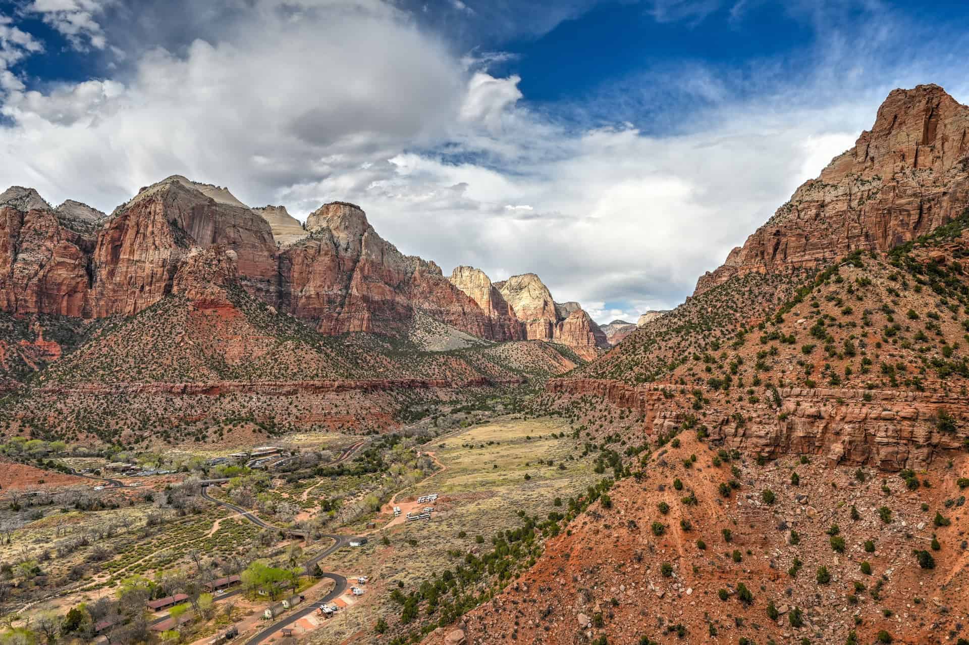
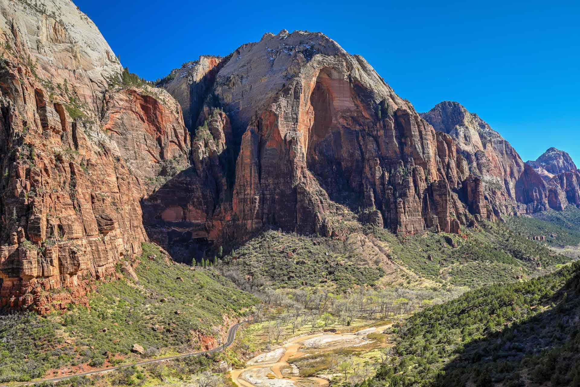
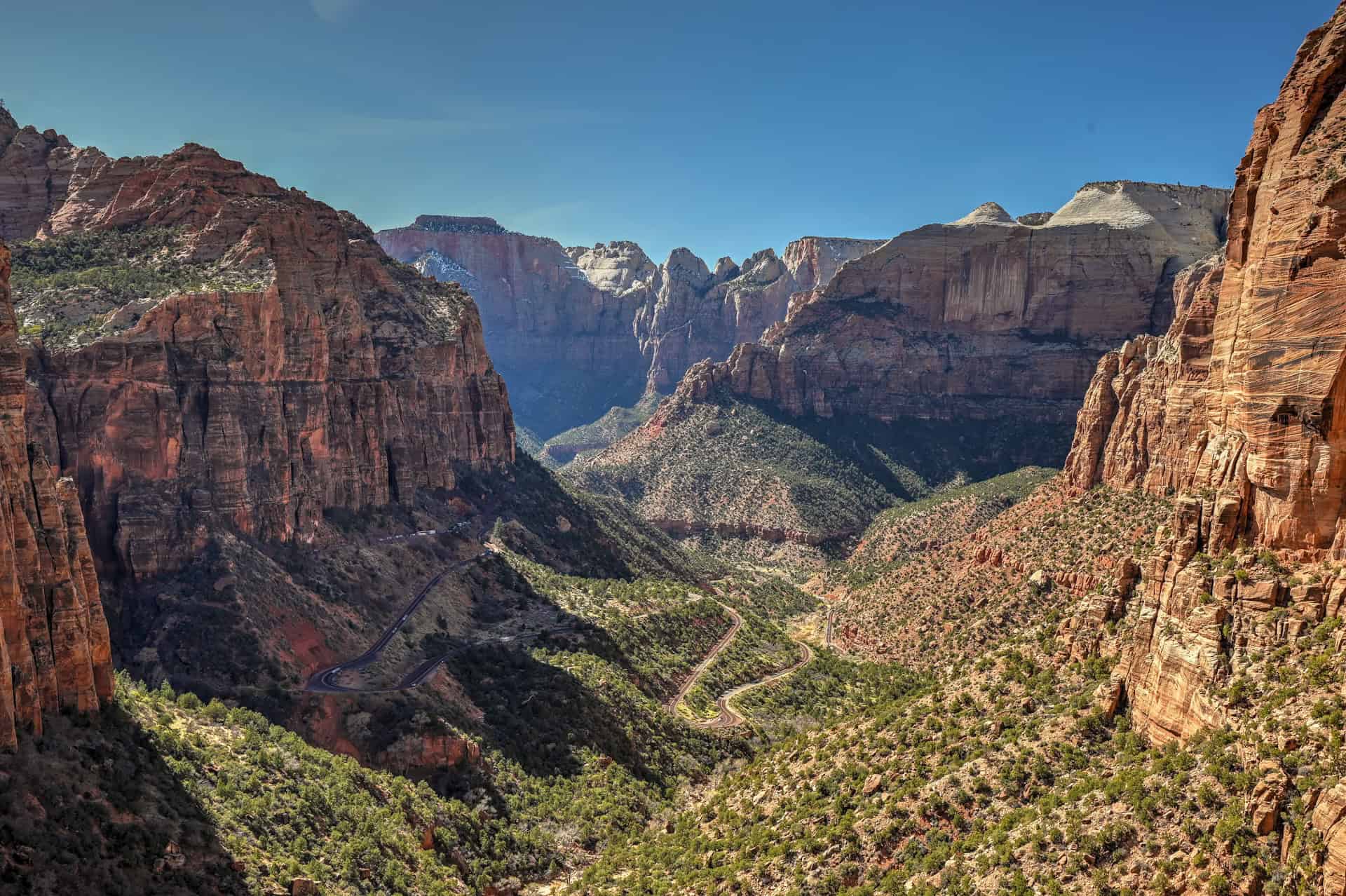
12. West Rim Trail (with or without Angels Landing)
The West Rim Trail is one of the most scenic hikes in Zion National Park, climbing high above the canyon along a series of switchbacks that offer increasingly expansive views.
Most hikers follow the section from The Grotto up to Scout Lookout, which includes the famous Walter’s Wiggles, a set of tight switchbacks that gain elevation quickly. From Scout Lookout, you can either stop and enjoy the panoramic views or continue onto Angels Landing, a narrow ridge hike requiring a permit.
Even without completing Angels Landing, the climb to Scout Lookout is one of the most rewarding viewpoints in Zion, with wide views across the canyon in multiple directions. And you can continue further along the West Rim trail beyond Scout Lookout, where very few hikers venture (at least compared to the numbers you’ll see on the rest of the trail).


Why it’s a great hike:
This trail combines a sustained climb with some of the best elevated views in Zion. The option to continue onto Angels Landing also makes it one of the most iconic and customizable hikes in the park.
Notable highlight: Panoramic canyon views from Scout Lookout (and Angels Landing for those continuing)
Location: Zion National Park (Zion Canyon)
Trail difficulty: Moderately challenging (steep climb to Scout’s Lookout; exposure on Angels Landing)
Typical hike duration: 2h30-4h (depending on turnaround point)
Trail fee: Included with Zion National Park entry
Potential drawback: Crowds can be significant, and Angels Landing requires a permit and includes exposed sections.
For detailed trail information, route descriptions, and photos, see our West Rim Trail Guide.
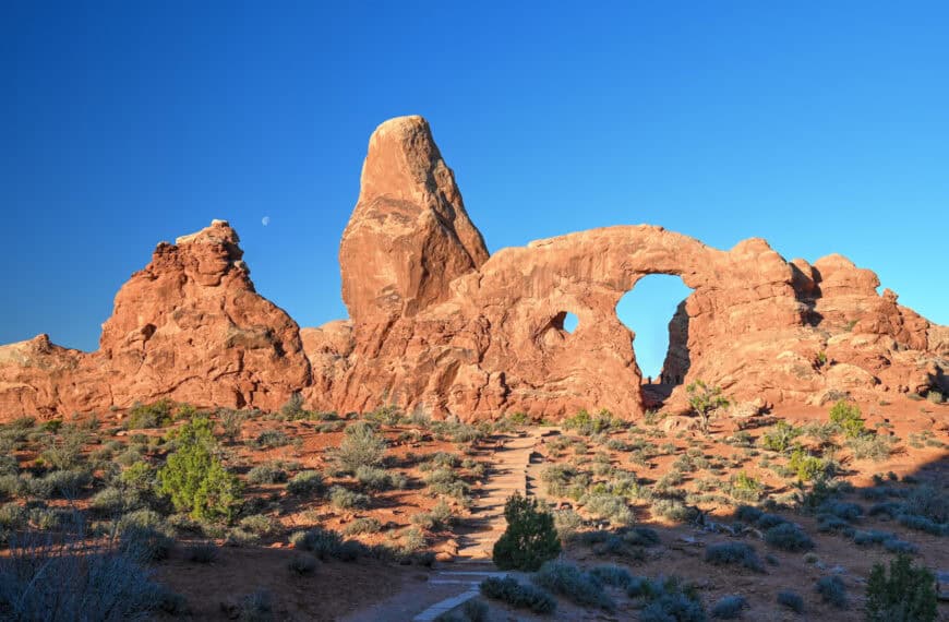
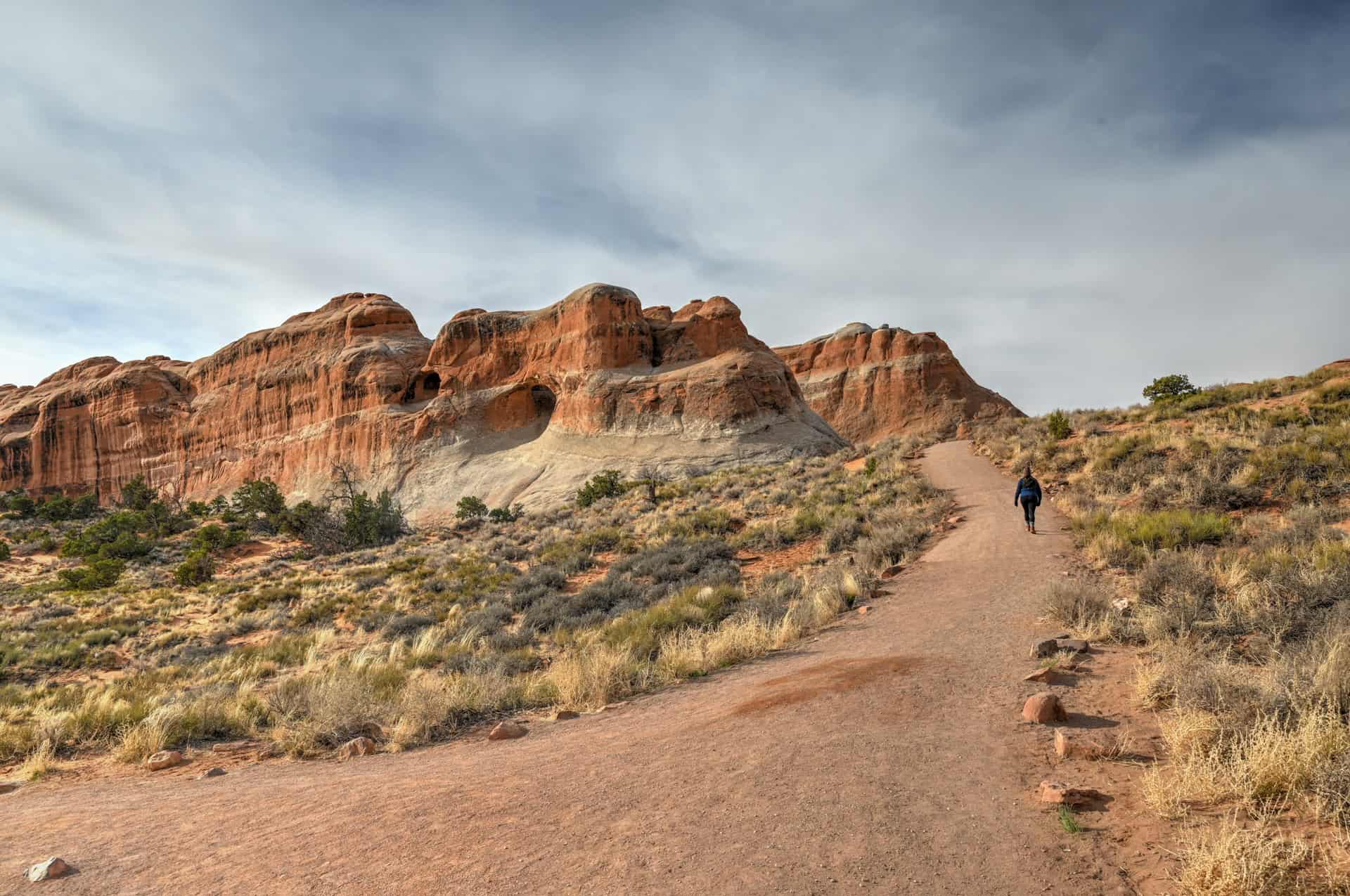
13. Devils Garden Trail
The Devils Garden Trail is the longest and most varied hike in Arches National Park, linking several arches across a rugged sandstone landscape in the northern part of the park.
The trail begins as an easy walk to Landscape Arch, one of the longest natural arches in the world. Beyond this point, the route becomes more adventurous, crossing narrow rock fins, slickrock sections, and uneven terrain as it continues toward more remote formations such as Double O Arch.
Many hikers choose to turn around at Landscape Arch, but continuing farther offers a more immersive experience with fewer crowds and a greater sense of exploration.


Why it’s a great hike:
This is one of the few hikes in the region that combines multiple major landmarks with a progressively more adventurous route. It offers both accessibility and the option for a more challenging experience.
Notable highlight: Landscape Arch and the more rugged terrain beyond it
Location: Arches National Park (Devils Garden area)
Trail difficulty: Easy to Landscape Arch; moderate beyond
Typical hike duration: 2–4+ hours (depending on how far you go)
Trail fee: Included with Arches National Park entry
Potential drawback: The full route includes exposed sections and light scrambling, which may not suit all hikers.
For detailed trail information, route descriptions, and photos, see our Devils Garden Trail Guide.
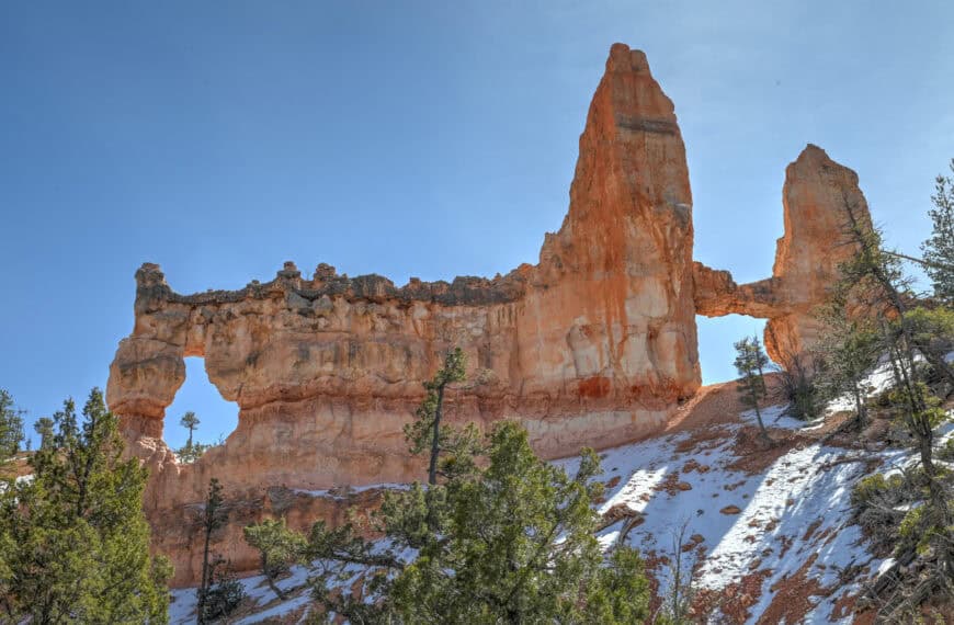
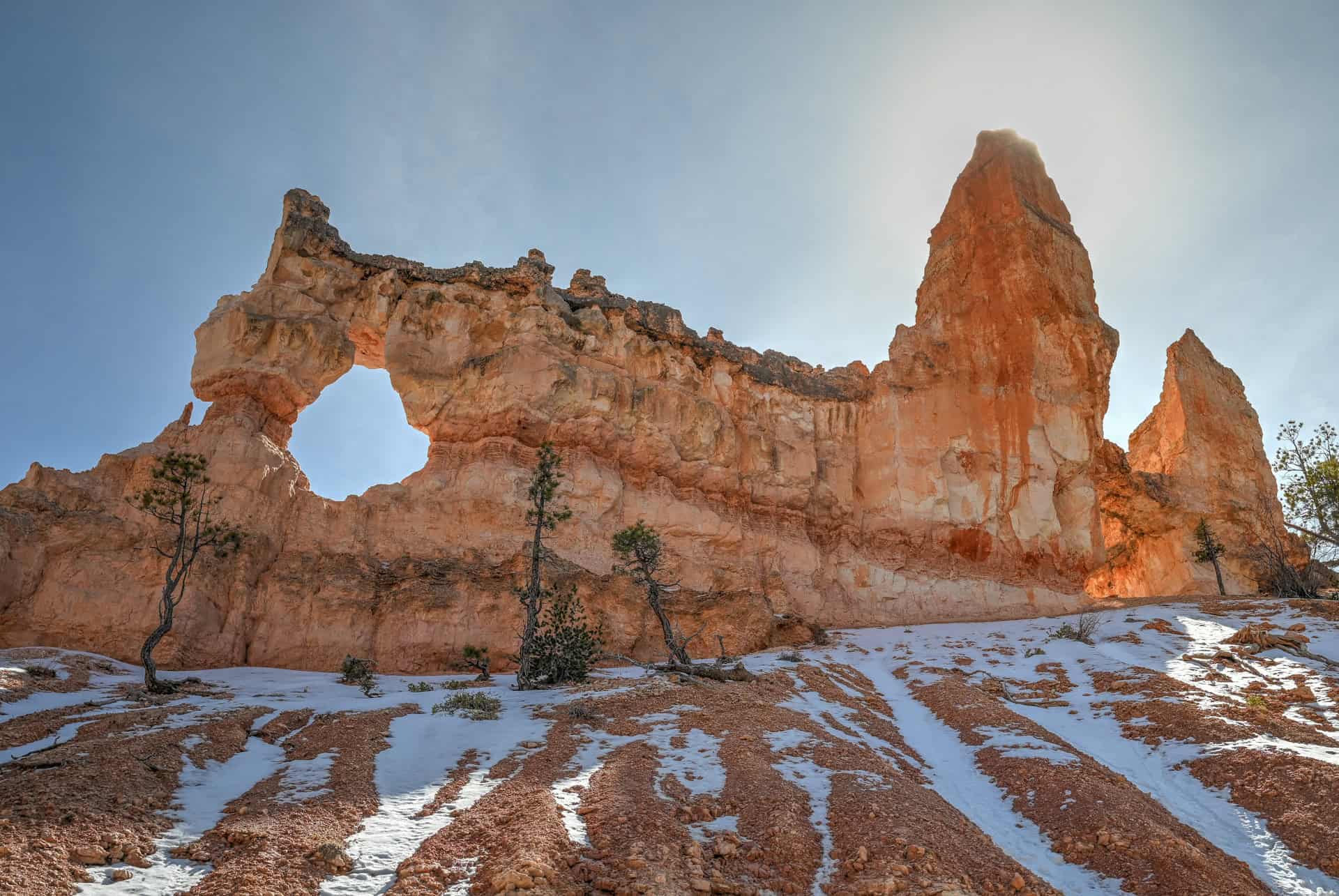
14. Tower Bridge Trail
The Tower Bridge Trail is one of the less crowded hikes in Bryce Canyon National Park, offering a quieter way to explore the park’s hoodoo landscape.
Starting from Sunrise Point, the trail descends from the rim into a more open section of the canyon, passing through scattered hoodoos and desert terrain before reaching Tower Bridge, a tall, narrow formation that stands apart from the denser clusters found in the main amphitheater.
Compared to more popular routes like the Navajo Loop, this trail feels more spacious and less confined, with fewer hikers along the way.


Why it’s a great hike:
This is a good alternative to the main amphitheater trails, offering similar scenery with fewer crowds and a more open feel.
Notable highlight: Tower Bridge formation rising prominently from the canyon floor
Location: Bryce Canyon National Park
Trail difficulty: Moderate (steady descent and climb back to the rim)
Typical hike duration: 2h-2h45
Trail fee: Included with Bryce Canyon National Park entry
Potential drawback: The steady climb back to the rim can catch hikers off guard, making the return leg feel noticeably tougher
For detailed trail information, route descriptions, and photos, see our Tower Bridge Trail Guide.
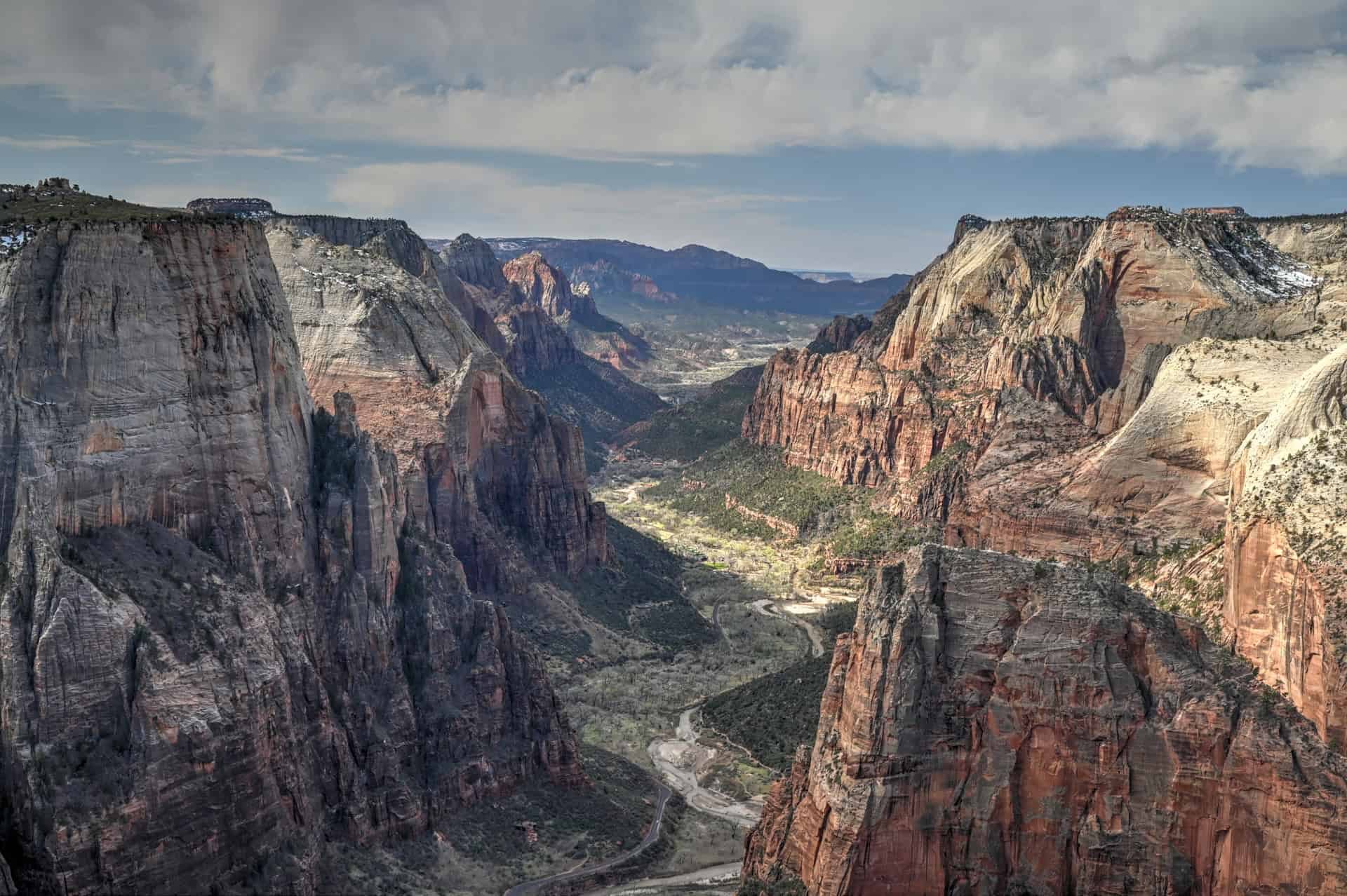
15. Observation Point via East Mesa Trail
Observation Point is one of the highest viewpoints in Zion National Park, offering a top-down perspective over the canyon that few other hikes can match. The East Mesa route provides the easiest access to this viewpoint, following a relatively flat path across a forested plateau before reaching the edge of the canyon.
Unlike the steep climbs found on many Zion hikes, this route builds gradually and remains mostly level, making it a more accessible way to reach one of the park’s most dramatic overlooks. The final viewpoint looks directly down onto Zion Canyon, with Angels Landing visible far below.


Why it’s a great hike:
This is one of the best effort-to-reward hikes in Zion. The trail itself is relatively easy, but the final viewpoint delivers one of the most expansive and unique perspectives in the park.
Notable highlight: Elevated viewpoint looking down onto Zion Canyon and Angels Landing
Location: Zion National Park (East Mesa access)
Trail difficulty: Easy-to-Moderate (mostly flat but a 7-mile trail)
Typical hike duration: 2h30-3h
Trail fee: Included with Zion National Park entry
Potential drawback: Access requires driving a rough dirt road, which can be difficult or impassable when wet, or securing transit with a shuttle to the trailhead.
For detailed trail information, route descriptions, and photos, see our Observation Point Hiking Guide.
If you need to book a rental vehicle for your hiking excursion, we highly recommend using Discover Cars to get the best rates on your rental in Utah, Nevada, and Arizona.
We also highly recommend Airalo (eSIM card) for your connectivity needs when travelling abroad. Airalo is the world’s first and largest eSIM store with eSIM plans for 200+ countries and regions worldwide.
Some More Trails: Honorable Mentions
These didn’t quite make the main list, but are still well worth considering depending on your itinerary:
Mesa Arch (Canyonlands National Park) – A very short walk to one of the most photogenic viewpoints in the region, especially at sunrise.


Canyon Overlook Trail (Zion National Park) – Short hike to one of the best viewpoints in Zion. Parking is limited and can be frustrating, but the overlook itself is quite jaw-dropping.
Moqui Sand Caves (near Bryce Canyon National Park) – Not a traditional trail, but a short, rope-assisted climb leads to a series of caves that are fun to explore.


Stairmaster Trail (near Moab) – A short but steep slickrock climb that feels more challenging than most hikes in this category, with great views at the top.


Goblin Valley (Goblin Valley State Park) – Less of a defined trail and more open exploration among hundreds of unique rock formations.


Explore More Utah National & State Park Guides
Continue exploring Utah with these detailed guides:
Zion National Park Guide
Capitol Reef National Park Guide
Goblin Valley State Park Guide
Monument Valley Guide
Bryce Canyon National Park
Canyonlands National Park
Arches National Park
Monument Valley
Photography Gear
If you like our photography, you might be interested in some of the gear we use to shoot our travel and hiking destinations.
Camera Body – Nikon Z 6ii Fx-series Mirrorless Body
Main Lens – NIKON 24-120mm F/4G ED VR AF-S
Zoom Lens – Sigma 745-306 150-600mm f/5-6.3
Polarizing filters – Urth Circular Polarizing (CPL)
Camera Tripod – K&F Concept 64-inch Camera Tripod
Mini-tripod – Lammcou Flexible Camera Tripod
Camera/hiking backpack – Vanguard Alta Rise 48 Backpack
Universal Travel Adapter – VYLEE Universal International Power Travel Plug
Other Travel Essentials
Travel Insurance
SafetyWing is a travel insurance company that offers comprehensive coverage for travellers. Includes Medical Insurance and Travel Insurance. Primarily geared towards long-term travellers, digital nomads, and expats.
e-Sim cards
Airalo is the world’s first and largest eSIM store with eSIM plans for 200+ countries and regions worldwide. With Airalo eSIMs, travellers can get connected the moment they land at their destination and avoid nasty data roaming charges
eSIMS are a sustainable alternative to single-use SIM cards – they are 100% digital, require less energy to produce and be re-used rather than disposed of.
Car Rentals
Discover Cars is our go-to website for car rentals. We almost always find our preferred rate there.
Transfer from Airport
Welcome Pickups is our favourite private transfer service, which you can pre-book at a fixed price. Currently available in 220 cities all over the world (mostly in Europe, but with several major cities in Asia, the Middle East and the US).
Kiwitaxi is another private transfer service – we haven’t tried it yet, but it’s currently available in a few more countries (102 as of 2024).
Hotels and Accommodations (coming soon)
Photography Prints
If you found this blog useful, you can help support our blog by purchasing low-cost digital prints. Printed physical prints are also available for purchase.


—–
Well, that wraps it up! We hope you enjoyed our guide to the 15 Best Hiking Trails in Southern Utah and that it will prove useful for planning your trip.
—–
You might also be interested in these related pages: