Located at the very end of the Arches Scenic Drive, the Devils Garden Trail offers one of the most varied hiking experiences in Arches National Park. Rather than leading to a single destination, the trail connects a series of sandstone arches scattered across a dramatic landscape of fins, slickrock ridges, and desert valleys. Along the way, hikers can visit several impressive formations, including Landscape Arch, one of the longest natural arches in the world, let alone Utah.
Most visitors choose to hike only the first section of the trail to Landscape Arch, which is considered easy and is mostly flat. The terrain becomes more rugged and adventurous beyond Landscape Arch, and the crowds noticeably thin out for those who continue, as the route crosses exposed slickrock fins and includes sections of light scrambling toward Double O Arch.
In this guide, we’ll cover everything you need to know about hiking the Devils Garden Trail, including trail details, what to expect along the route, the best sections to prioritize, and practical tips for navigating one of the park’s most iconic hikes.
The Devil’s Garden Trail – At a Glance
A favorite among hiking aficionados – The Devils Garden Trail is one of the few hikes in Arches that feels like a proper backcountry-style adventure, with longer distances and more varied terrain than most trails in the park.
Two distinct hiking sections – The first portion of the trail leads to Landscape Arch and is considered easy. Beyond this point, the route toward Double O Arch becomes more rugged and adventurous.
Multiple arches along the route – Highlights include Tunnel Arch, Pine Tree Arch, Landscape Arch, Partition Arch, Navajo Arch, and Double O Arch.
One of the park’s most popular hikes – The Devils Garden trailhead is located at the end of the scenic drive and fills quickly during busy months, especially in spring and fall.
Trail Difficulty: Easy to Landscape Arch, Moderate to Double O Arch
Time Required: 1h (Landscape Arch) | 2h-2h30 (Double O Arch)


Disclosure: This page (Devil’s Garden Trail) may contain product affiliate links. At no additional cost to you, we may receive a commission for purchases made through these links. More details can be found on our disclosure and policies page.
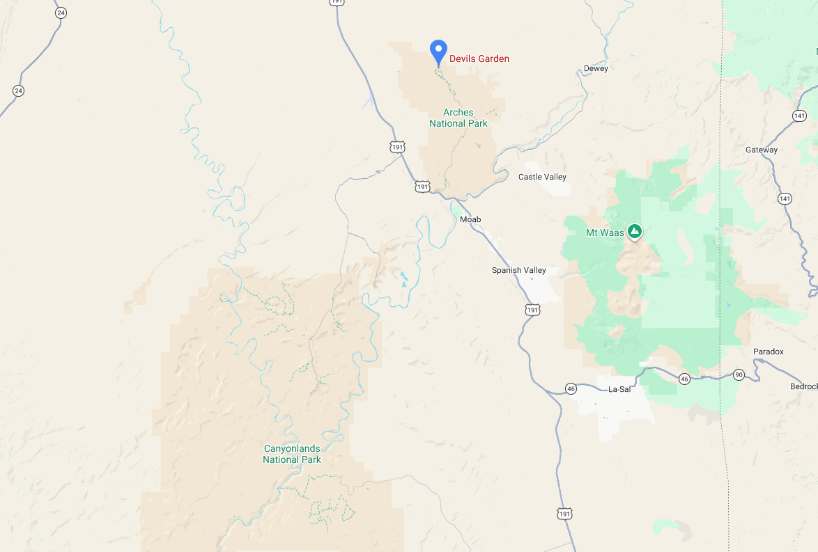
Devil’s Garden Trail: Location, Map, and How to Get There.
The Devil’s Garden Trail is located in Arches National Park, in eastern Utah, just outside the town of Moab, and is easily accessed via U.S. Highway 191, making it one of the most convenient national parks in Utah to reach.
Driving Times to Arches National Park
- Moab: 10–15 minutes
- Canyonlands National Park: 45 minutes
- Capitol Reef National Park: 2 hours 30 minutes
- Salt Lake City: 3 hours 45 minutes
- Las Vegas: 6 hours 30 minutes
These times assume clear weather and normal traffic conditions.
If you need to book a rental vehicle for your hiking excursion, we highly recommend using Discover Cars to get the best rates on your rental in Utah, Nevada and Arizona.
We also highly recommend Airalo (eSIM card) for your connectivity needs when travelling abroad. Airalo is the world’s first and largest eSIM store with eSIM plans for 200+ countries and regions worldwide.
Devil’s Garden Trail – Trailhead Access, Parking & Fees
Trailhead Location
The Devil’s Garden Trailhead is located at the very end of the Arches Scenic Drive, approximately 18 miles (29 km) from the park entrance (link to Google Maps).
To reach the trailhead, simply follow the main park road north through Arches National Park until it terminates at the Devils Garden parking area. The road is fully paved and suitable for all standard vehicles.
Because the trailhead sits at the furthest point inside the park, most visitors reach it after driving past several of the park’s major stops, including Balanced Rock, the Windows Section, and Delicate Arch Road.
Trailhead parking lot
The Devil’s Garden Trailhead has a large paved parking lot, but it fills quickly during busy periods due to the popularity of the hike.
Parking congestion is most common between mid-morning and early afternoon, particularly in spring and fall when visitor numbers are highest, and hiking temperatures are ideal. Because this trailhead is located at the end of the scenic drive, many visitors arrive later in the morning after stopping at other viewpoints first. So if you want to beat the crowds and avoid parking issues, it’s best to arrive as early as possible.
Parking turnover is usually steady throughout the day, but short waits for spaces are common during peak hours. Park staff and volunteers often help manage traffic and parking during peak times
Facilities
Vault toilets are located next to the parking lot.
Trail Opening Hours
The Devil’s Garden trail is accessible year-round, 24 hours a day, weather permitting.
However, hiking the trail in darkness is uncommon and not recommended for most visitors, particularly on the upper sections toward Double O Arch, where the route crosses slickrock fins and uneven terrain.
Entrance Fees for Arches National Park
Anyone visiting Arches National Park, whether to hike, drive the scenic road, or explore its iconic arches, must pay the applicable entrance fee to the National Park Service.
Entrance Fees (per vehicle, valid 7 days)
Private vehicle: $30
Motorcycle: $25
Individual (on foot, bicycle, etc.): $15
Annual Pass Options
Southeast Utah Parks Pass: $55 – valid for one year and covers Arches, Canyonlands National Park, and Hovenweep National Monument.
America the Beautiful Pass: $80 – valid for one year at all U.S. National Parks and more than 2,000 federal recreation sites nationwide. This is the best value if you plan to visit multiple national parks within a year.
Passes can be purchased at the park entrance station, at the Visitor Center, or online through the USGS website or via the REI store.
—> Most visitors exploring Utah’s “Mighty 5” parks (Arches, Bryce Canyon, Canyonlands, Capitol Reef, and Zion) should strongly consider the America the Beautiful Pass: it saves money and avoids the hassle of buying separate entry fees at each park.
Devil’s Garden: Trail Stats, Difficulty, and Map
Devils Garden Trail – up to Landscape Arch
Distance: 2 mi / 3.2 km round trip
Route Type: Out & Back
Elevation gain: 250 ft / 75 m (cumulative elevation gain)*
AllTrails rating (2026): 4.8, 3700 ratings
Duration: Most people complete the full trail in 45-60 minutes
*Mostly through short ups and downs; the trail definitely feels flatter than those numbers.
Trail difficulty level assessment:
Very Easy | Easy | Moderate | Moderately Challenging | Challenging
This section of the trail leads to Landscape Arch, one of the longest natural arches in the world. Along the way, short spur trails allow visitors to see Tunnel Arch and Pine Tree Arch, which add about 0.6 mi (1 km) to the distance listed above, without significant additional elevation gain
Devils Garden Trail – up to Double O Arch
Distance: 4.3 miles (7 km)
Route Type: Out & Back
Elevation gain: 700 ft / 210 m (cumulative elevation gain)*
AllTrails rating (2026): 4.9, 5100 ratings
Duration: Most people complete the full trail in 2h-2h30
*Partly due to repeated ups and downs, the elevation difference between the trail’s lowest and highest point is about 350 feet (105 m)
Trail difficulty level assessment:
Very Easy | Easy | Moderate | Moderately Challenging | Challenging
Continuing beyond Landscape Arch leads deeper into Devils Garden toward Double O Arch., Along the way, spur trails lead to Partition Arch and Navajo Arch, which adds about 1 mi (1.6 km) to the listed distance above, without significant additional elevation gain.
Optional Extended Loop (Primitive Trail)
Experienced hikers can also complete a full Devil’s Garden loop by returning via the Primitive Trail, creating a route of roughly 13 km (8 miles). This section of the trail is more challenging than the main route and involves navigating slickrock fins, uneven terrain, and sections where the path is less clearly defined. Hikers attempting the full loop should plan for at least 3.5–4 hours and be comfortable with route finding and light scrambling.
Devil’s Garden – Trail Description and What to Expect
Trailhead to Landscape Arch
The Devils Garden Trail begins from the parking area at the end of the Arches Scenic Drive, following a well-defined dirt and gravel path that gradually climbs through desert terrain.


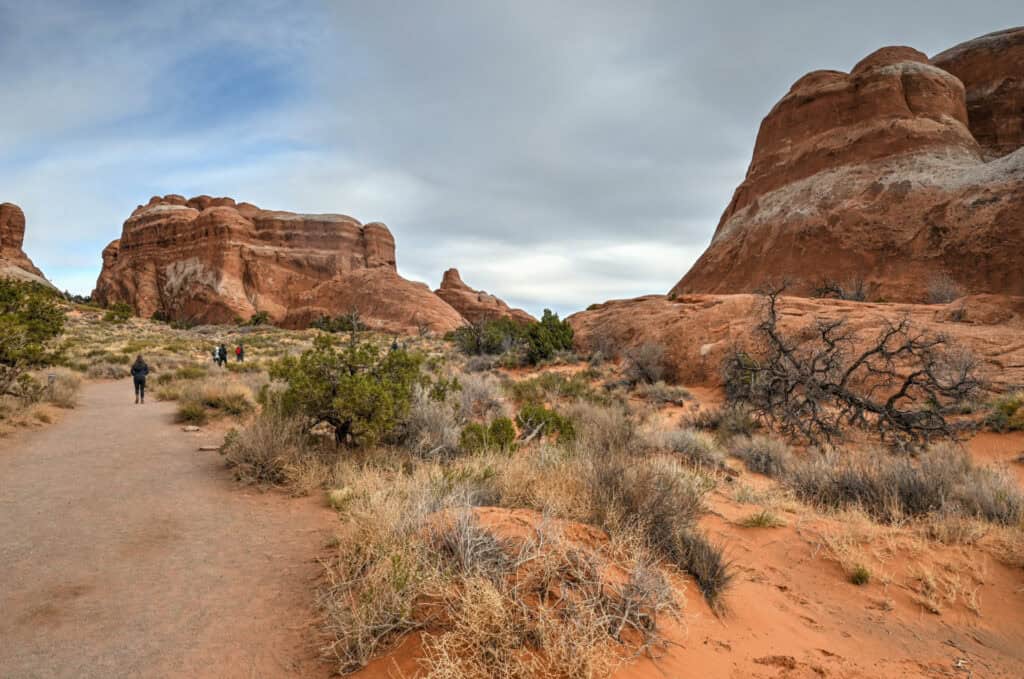
The first portion of the trail is relatively straightforward, with only minor elevation gain and wide views across the surrounding rock formations. As you progress deeper into the Devil’s Garden area, the landscape becomes increasingly dramatic, with towering rock formations and narrow sandstone walls rising on either side of the trail.
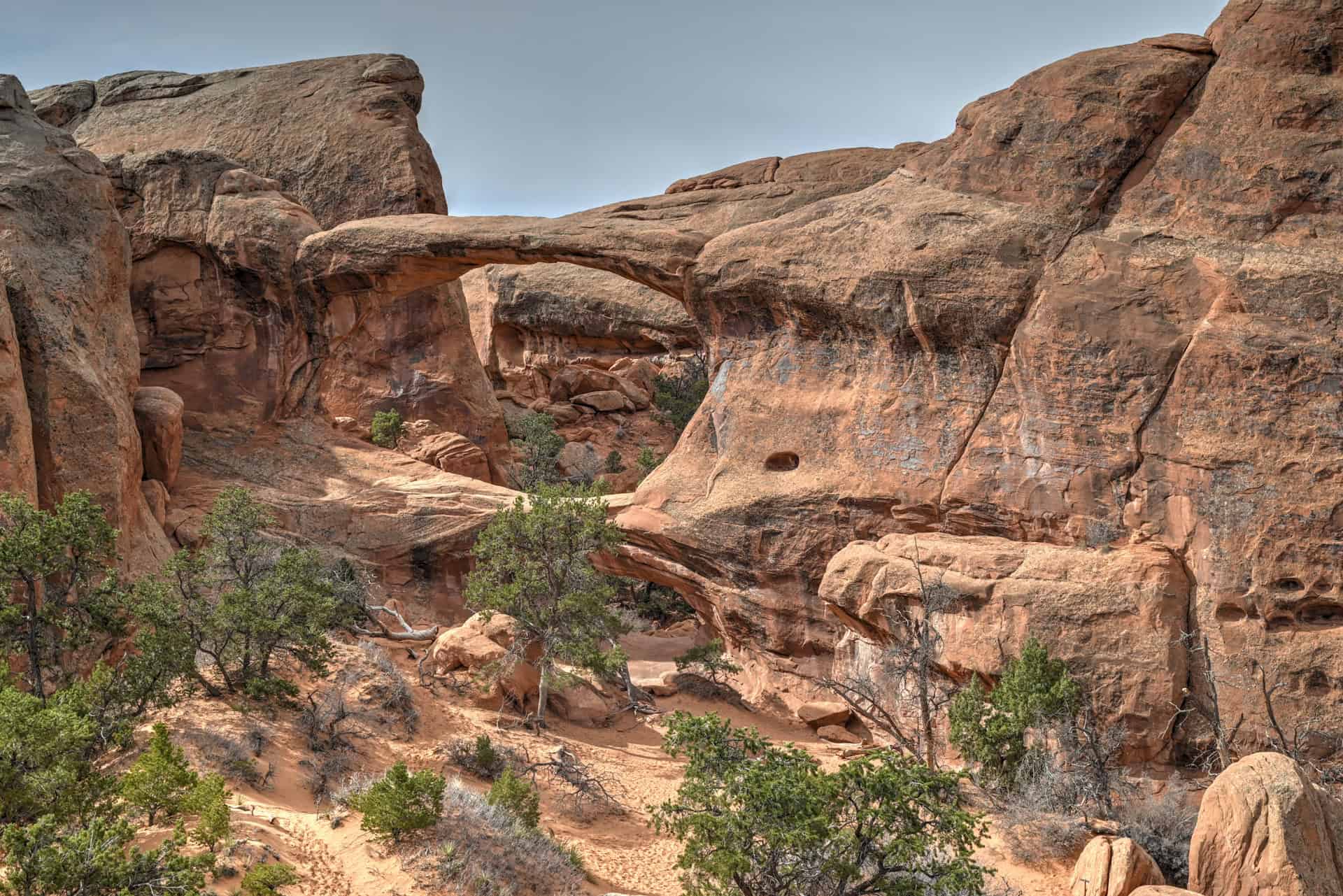
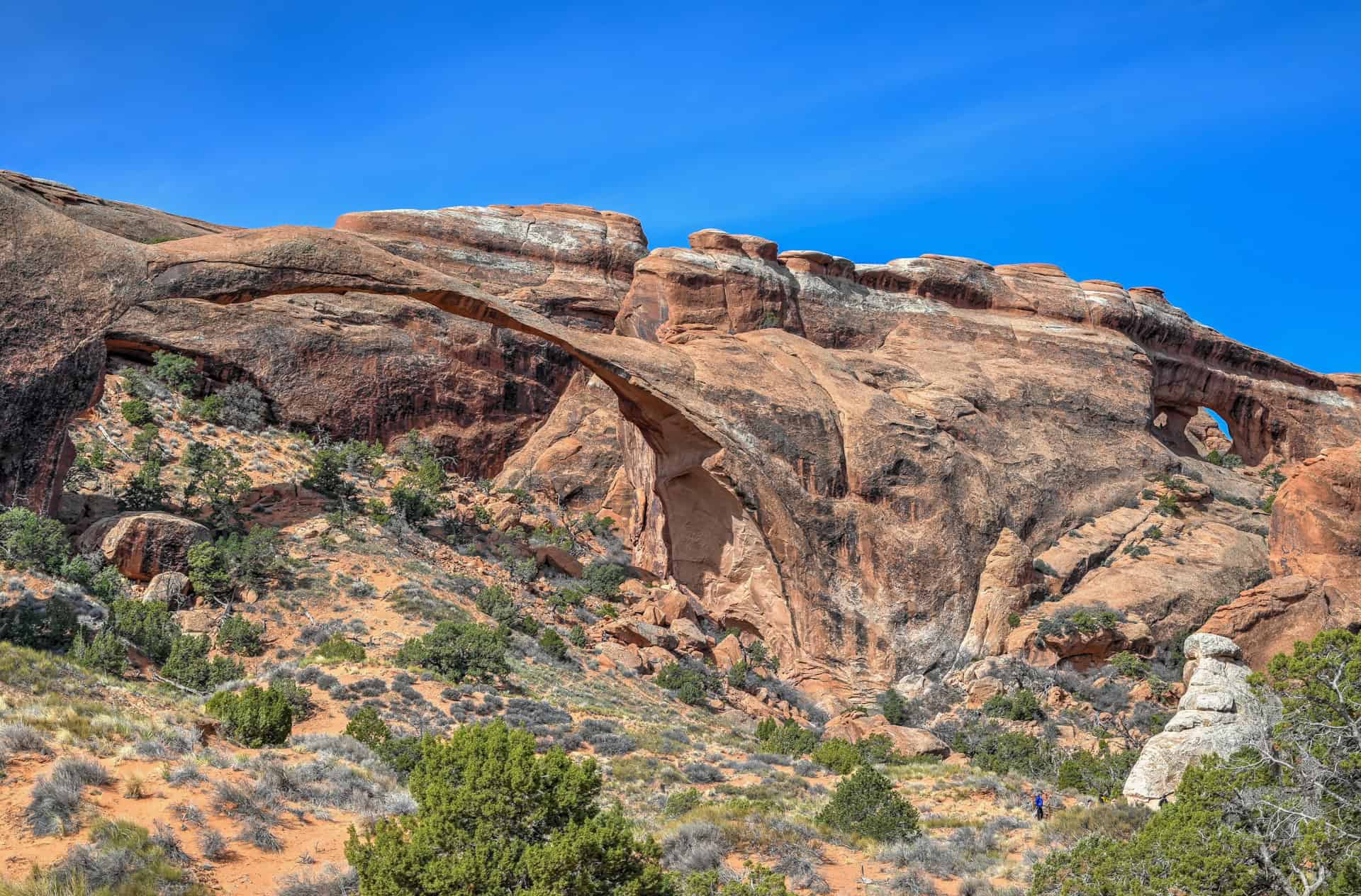
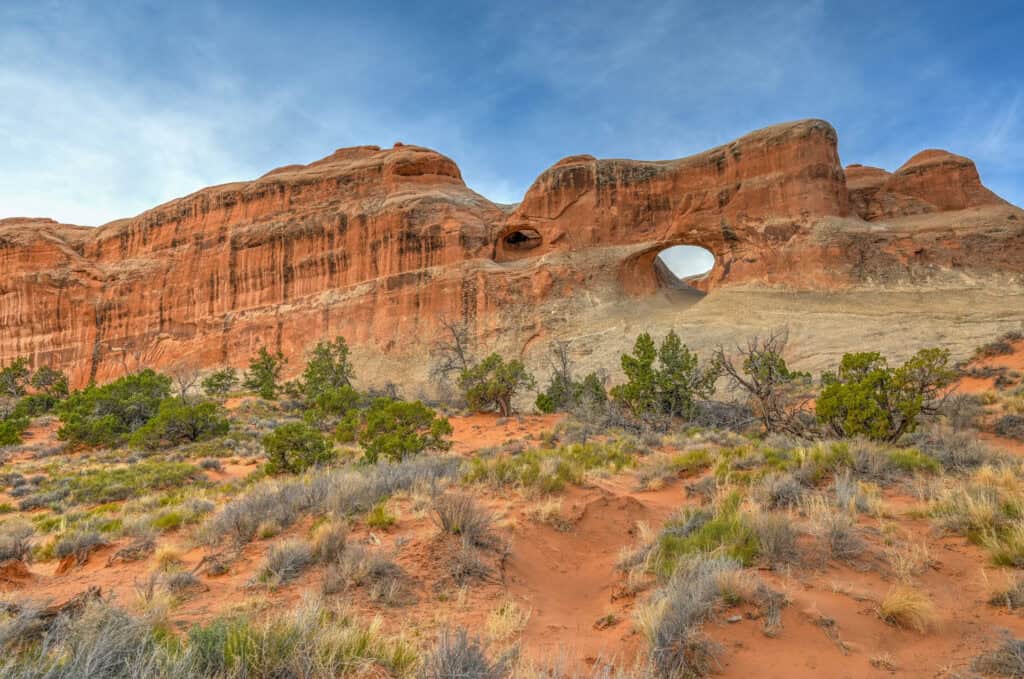
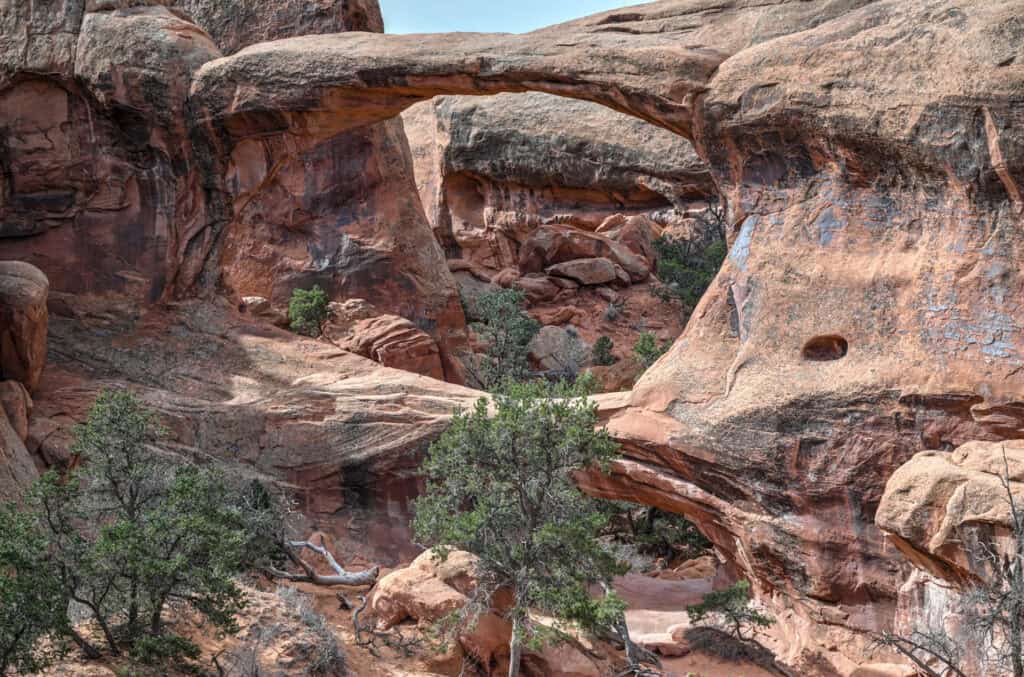
After roughly 1.3 km (0.8 mi), the trail reaches Landscape Arch, one of the longest natural arches in the world. The arch spans more than 90 meters (290 ft) across the canyon and appears remarkably thin and delicate when viewed from below.


A large viewing area allows visitors to stop and admire the arch before deciding whether to continue deeper into the Devil’s Garden trail system.
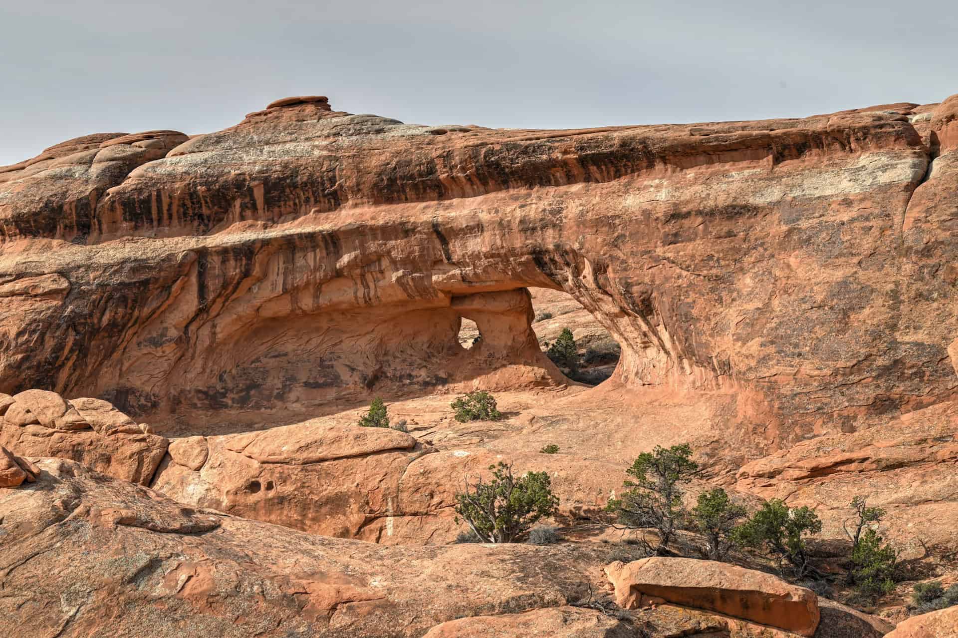
From the viewing area, you can also get a glimpse of Tunnel Arch (top right corner), an arch you can reach by continuing further along the trail.
Optional Spur: Tunnel Arch & Pine Tree Arch
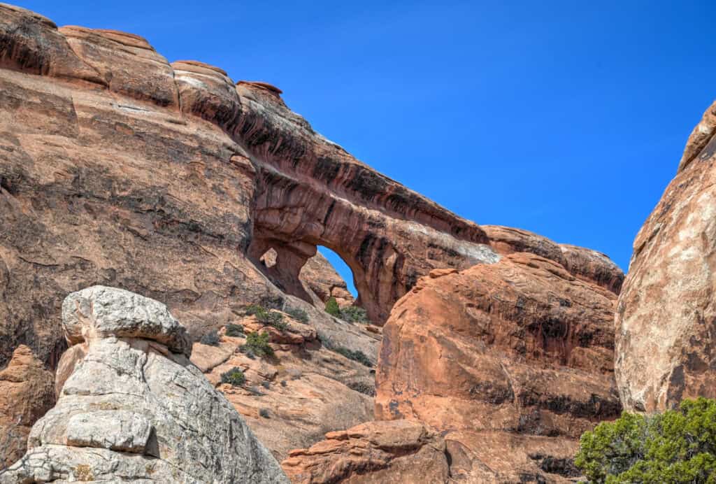
Before reaching Landscape Arch, a short spur trail branches off toward Tunnel Arch and Pine Tree Arch.
The detour adds only a few minutes to the hike and is well worth the effort. Tunnel Arch appears as a large opening high in the sandstone wall, almost like a natural window carved into the rock face perched well above the canyon floor.


A short distance farther along the spur lies Pine Tree Arch, which sits at ground level within a shallow sandstone alcove and is framed by desert vegetation and surrounding rock fins.


Because many visitors focus on Landscape Arch, this short detour is often quieter than the main trail, making it a pleasant stop before continuing deeper into Devil’s Garden.
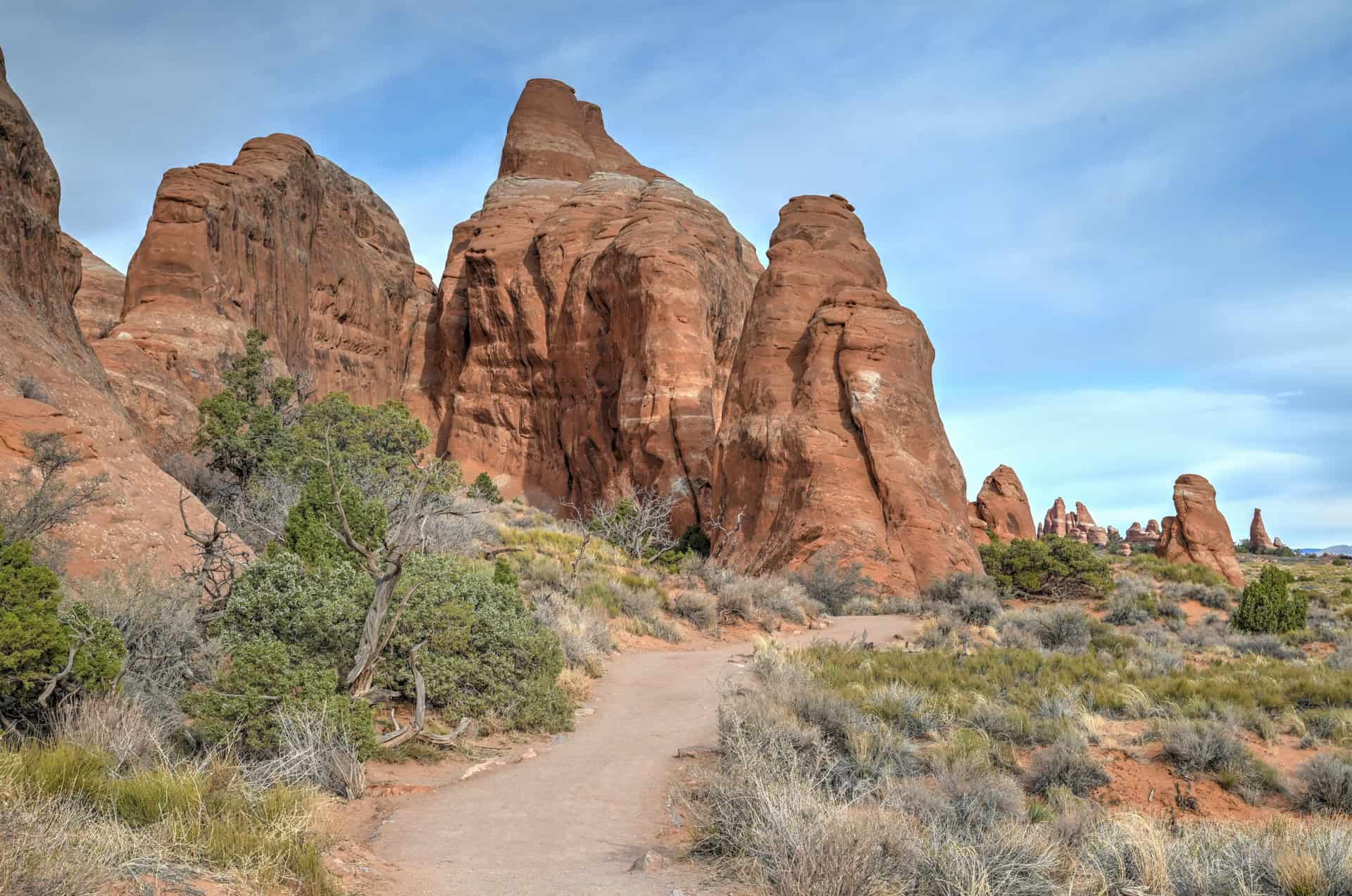
Landscape Arch to Double O Arch
Beyond Landscape Arch, the character of the trail changes noticeably as it becomes more rugged and adventurous. Almost immediately after passing Landscape Arch, this is where you’ll encounter the most challenging section of the route: a steep sandstone fin that must be climbed to continue along the trail. Most hikers use their hands for balance and support here while ascending this section. Although short, the climb is steep enough to surprise anyone expecting the easier terrain found earlier on the trail.
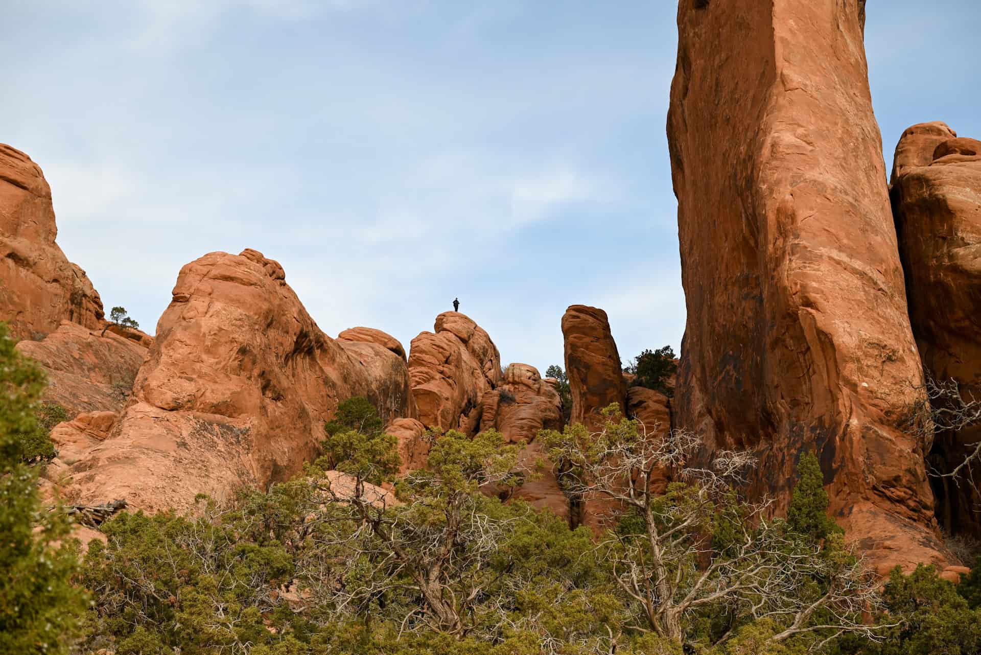
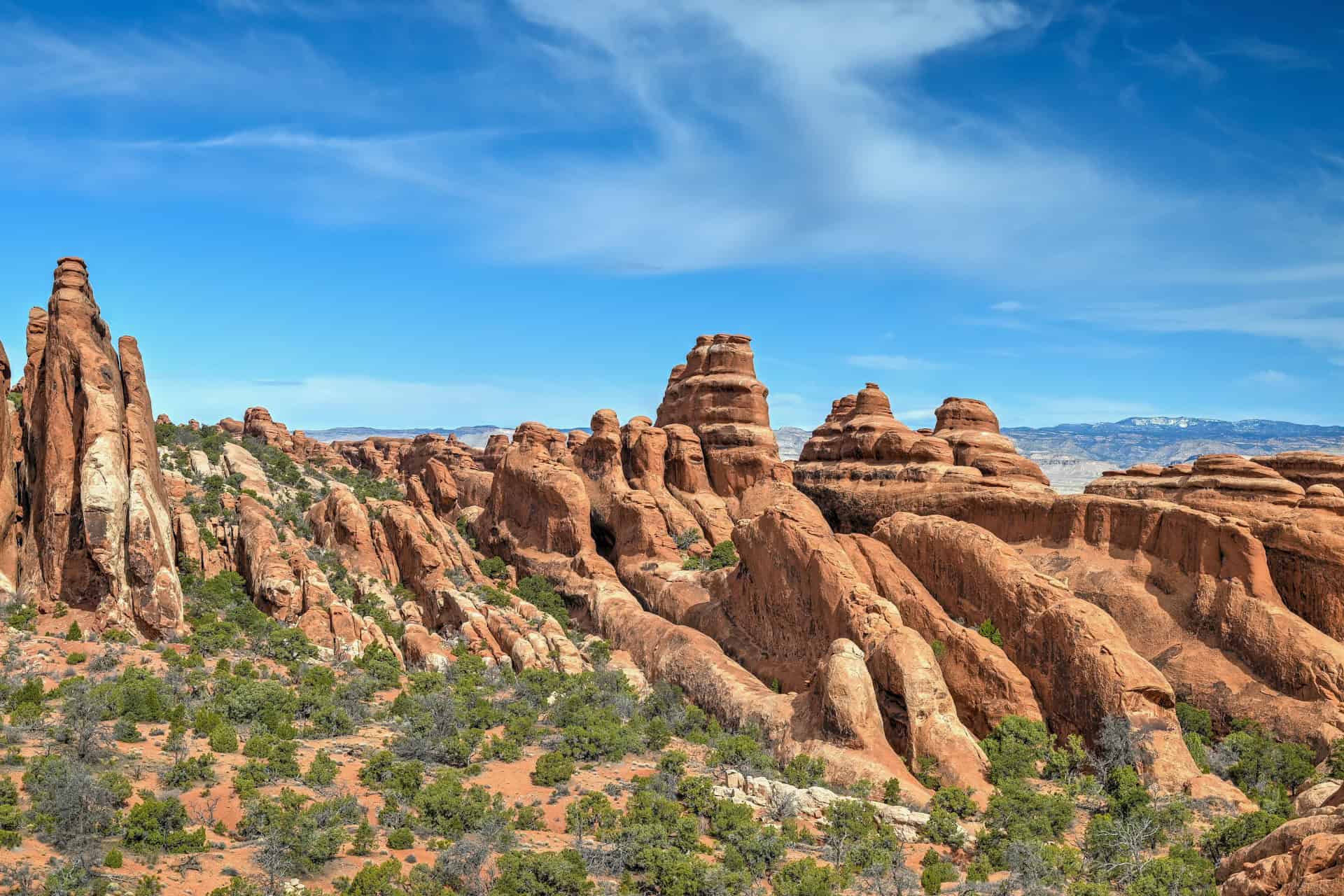
Once past this initial climb, the trail becomes considerably more manageable. The route first continues along a wide plateau, before eventually continuing across a series of sandstone ridges and slickrock fins. Overall, the terrain along this section of the trail is mostly flat with gentle undulations and only a few short scrambling moments to move on and off the fins.


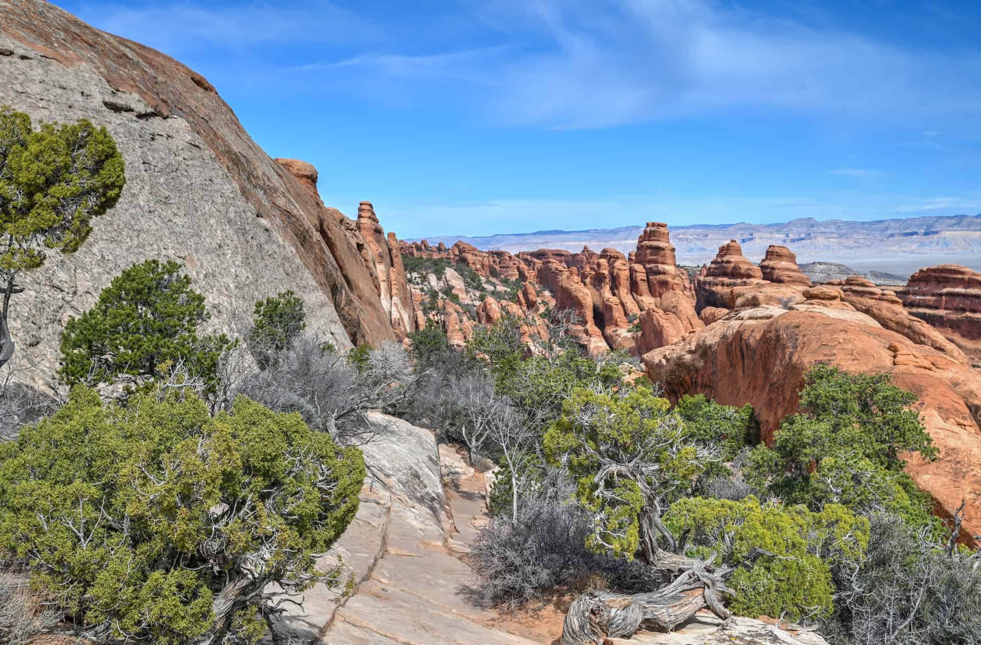
Painted trail markers guide the way across the slickrock, helping hikers stay on route as the trail winds deeper into the Devil’s Garden area.
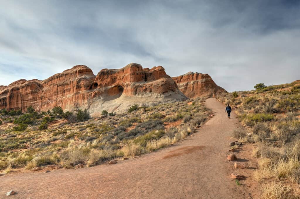
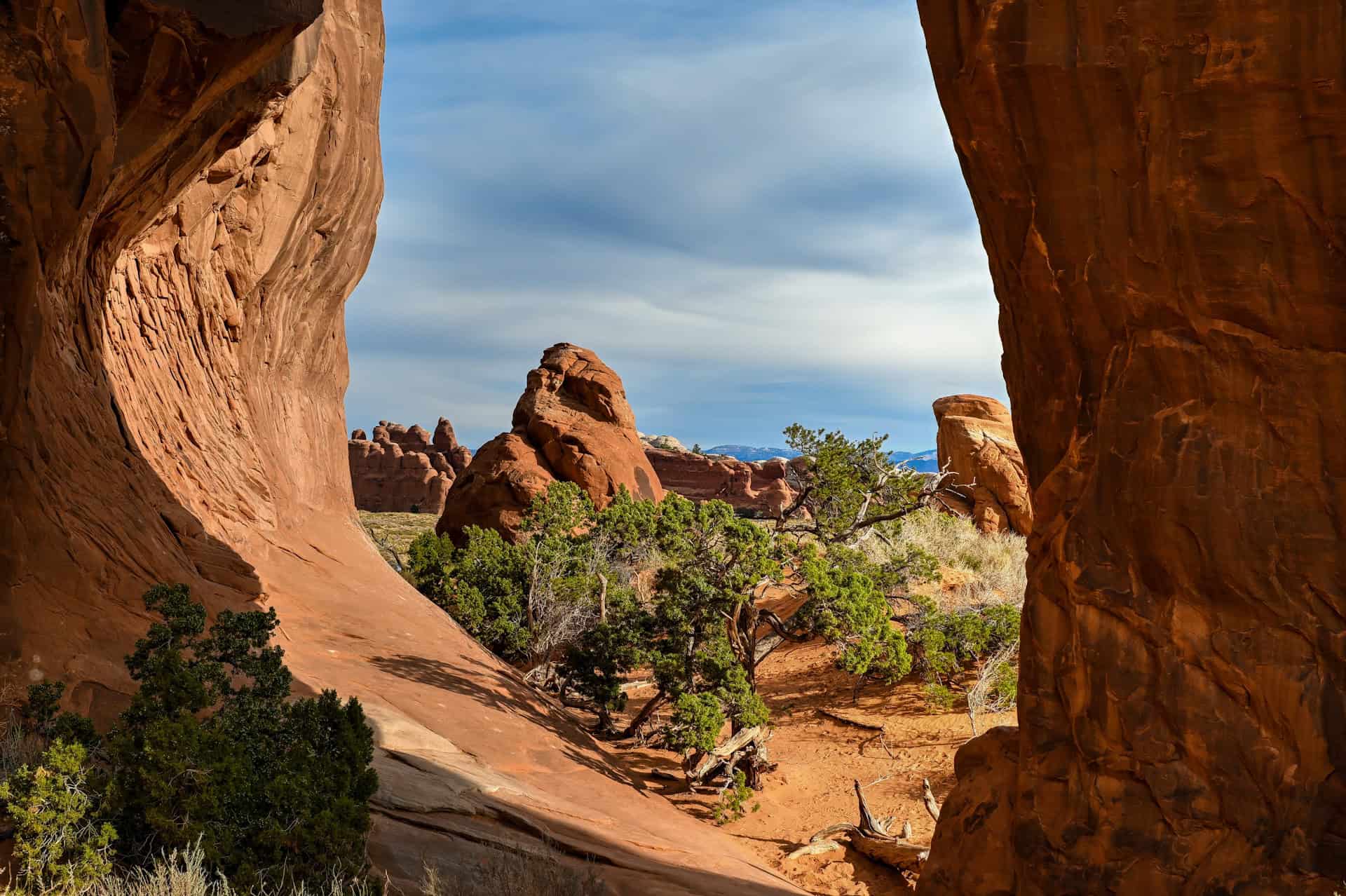
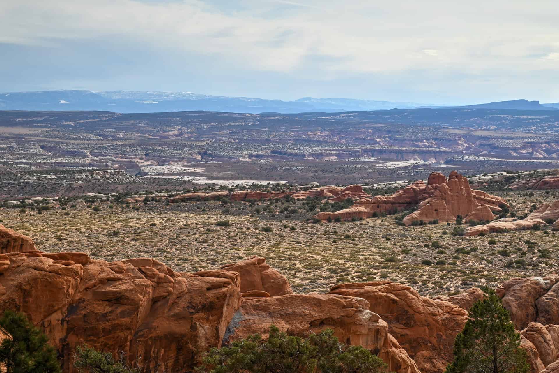
Near the end of the trail, you’ll come across Black Arch Overlook, a small viewpoint offering sweeping views across the surrounding desert landscape.


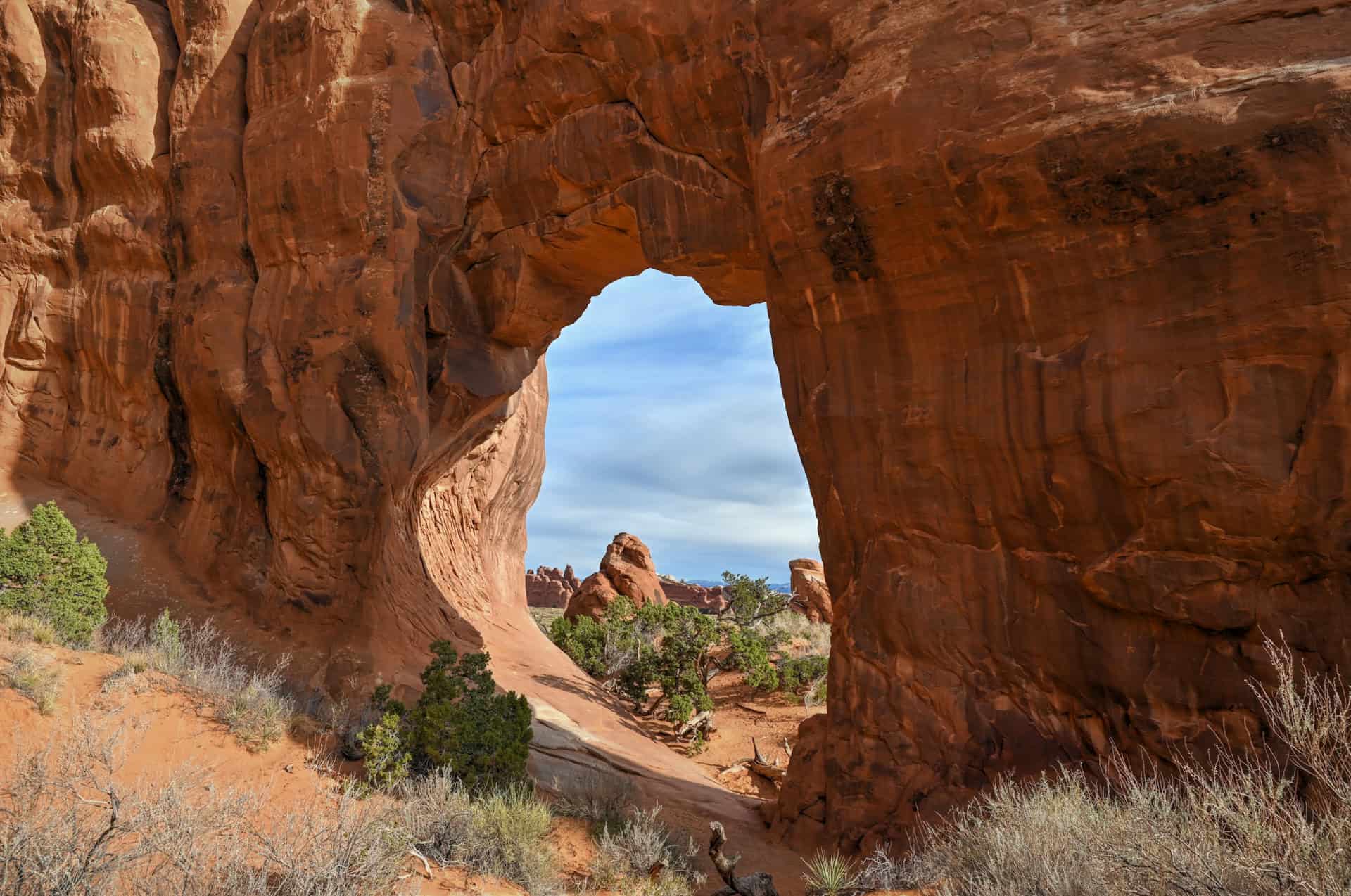
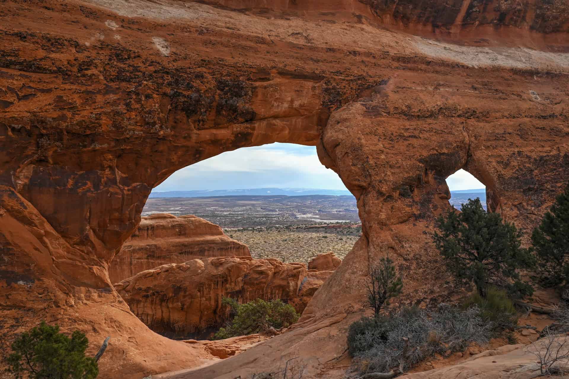
Shortly afterward, the trail reaches Double O Arch, one of the most impressive formations in the Devil’s Garden area. Two large arches share the same rock base, creating a striking double opening that rises dramatically above the desert floor.

Most people will retrace their steps and head back from the trailhead from here. Some will continue slightly further until the rock formation known as Dark Angel, and from there follow the primitive trail to form a loop trail to bring them back to the trailhead. Returning via the primitive trail is more challenging than the main route and significantly longer to complete.
Optional Spurs: Partition Arch & Navajo Arch
Two additional spur trails branch off between Landscape Arch and Double O Arch. Both are flat and easy to follow.
The first leads to Partition Arch, which offers a unique perspective looking out across the Devil’s Garden landscape through the opening of the arch.
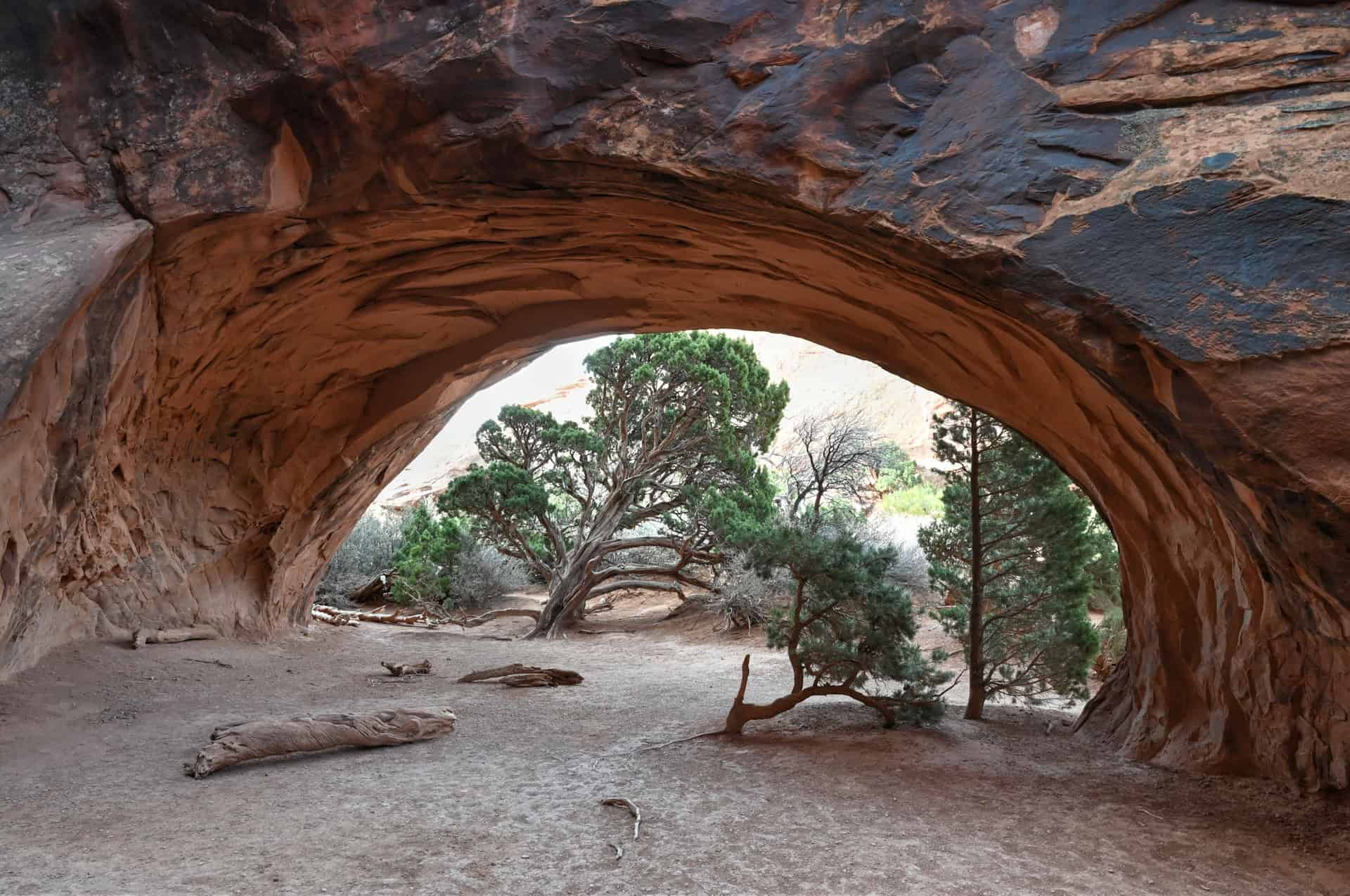
The second spur leads to Navajo Arch, a shaded alcove-style arch carved into the sandstone wall.


If you’re unsure whether to add these detours, one strategy is to wait until the return leg of the hike and decide then. If you still have the time and energy after reaching Double O Arch, these short side trips can be easily incorporated on the way back.
The Devil’s Garden – Additional Details and Hiking Tips
Canine companions: Dogs are not permitted on the Devils Garden Trail. Pets are only allowed in designated areas of Arches National Park, primarily on paved roads, parking areas, and campgrounds. They are prohibited on all hiking trails within the park.
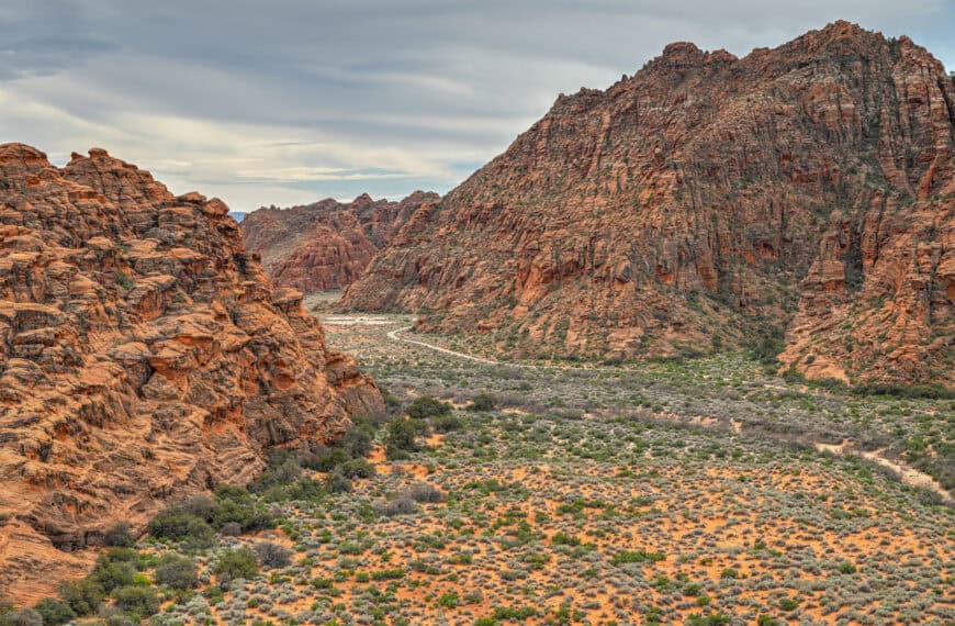
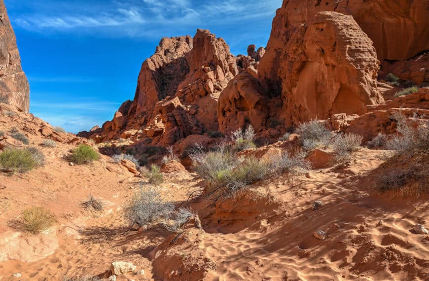
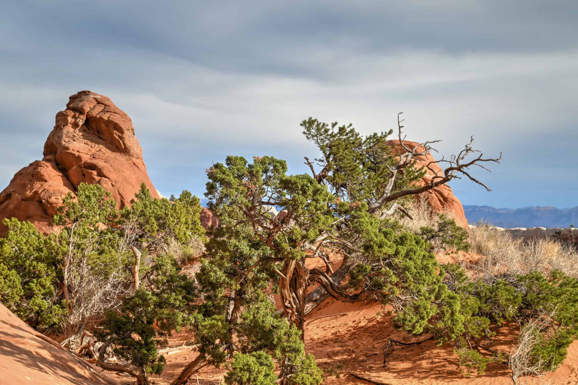
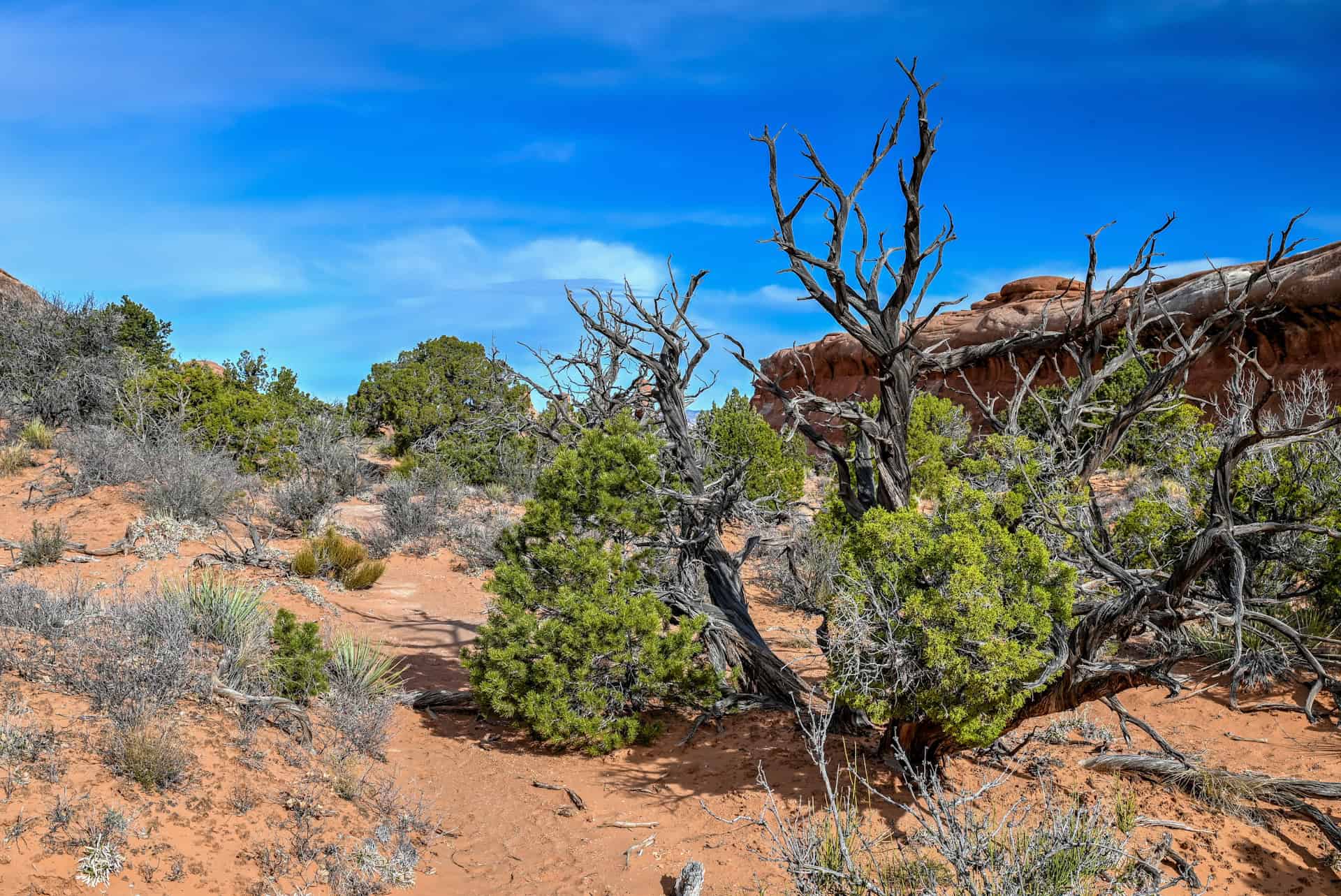
Trail environment: The Devil’s Garden Trail winds through one of the most dramatic landscapes in Arches National Park. The route passes through a maze of sandstone fins, narrow ridges, and desert valleys dotted with juniper and pinyon pine. Unlike many shorter hikes in the park, this trail ventures deeper into the Devil’s Garden area, where the terrain becomes increasingly rugged and remote. Shade is limited for most of the hike, especially along the slickrock fins beyond Landscape Arch.
Route signage: The first portion of the trail leading to Landscape Arch is well defined and easy to follow. Beyond Landscape Arch, the trail crosses open slickrock where the route may not always be immediately obvious. Painted trail markers placed directly on the rock help indicate the correct direction, and occasional cairns may also mark the path. Using an app such as AllTrails can be helpful if you are unsure of the route.
Trail surface / Technical aspects: The trail begins on packed dirt and gravel before transitioning to slickrock and sandstone ridges farther along the route. The most challenging section occurs shortly after Landscape Arch, where hikers must climb a steep sandstone fin. Many visitors use their hands for balance during this short ascent. Beyond this point, the trail follows a series of slickrock ridges with occasional scrambling sections as hikers move on and off the fins.
Slope and effort: The hike to Landscape Arch involves only light elevation gain and is suitable for most visitors. Continuing toward Double O Arch requires more effort, with sections of uneven terrain and short scrambles. While the overall elevation gain remains moderate, the slickrock terrain and exposed sections can make the hike feel more strenuous than the distance alone might suggest.
Previous Hiking Experience: The section to Landscape Arch is accessible to most visitors with basic fitness levels. The extension to Double O Arch is better suited for hikers comfortable with uneven terrain and light scrambling.
Cell Service: Cell reception along the trail is unreliable. Some visitors may receive a weak signal near the trailhead, but coverage often disappears deeper into the Devils Garden area.
Leave No Trace: Stay on marked trails and follow painted route markers when crossing slickrock. Avoid climbing on fragile sandstone formations and cryptobiotic soil. Pack out all trash and respect the delicate desert environment.
Bugs: Insects are generally minimal. Occasional flies may appear during warmer months, but mosquitoes are rare in this dry desert environment.
Equipment: Sturdy hiking shoes with good traction are recommended, particularly for the slickrock sections beyond Landscape Arch. Bring plenty of water, sunscreen, sunglasses, and a hat, as shade along the trail is limited.
Weather and Exposure: The trail is largely exposed to the sun and can become extremely hot during the summer months. Slickrock surfaces also reflect heat, making the hike feel warmer than the air temperature suggests. After rain, sandstone can become slippery, especially on steeper sections of the trail.
Current Trail Conditions: Check the National Park Service alerts page for Arches National Park before your visit for updates on weather conditions, trail advisories, or temporary closures.
Hiking Packing List
All Trails subscription – This comes in really handy for areas with little or no cell reception, as the annual subscription allows you to download trail maps for offline use.
External Battery – If you are using your phone to track your progress along the trail or to help with navigation, you certainly don’t want your phone to die on you. That’s especially true in the unlikely event that you might get hurt or need assistance.
Hiking poles – These can be particularly useful in steep trails or muddy/boggy trail conditions.
Water Filter Bottle – The Life Straw bottle is an advanced water bottle with a filter that not only improves water taste but more importantly filters out bacteria and parasites, chemicals and microplastics.
Headlamp – very practical and a smart choice if you plan to start your hike before sunrise or finish it after sunset.
Best Time to Hike the Devil’s Garden Trail
Because the Devils Garden Trailhead sits at the very end of the Arches Scenic Drive, the timing of your hike can significantly affect both crowds and parking availability.
Early Morning (Best for Parking and Cooler Temperatures)
Early morning is generally the best time to start the hike, particularly if you plan to continue beyond Landscape Arch toward Double O Arch.
The trailhead parking lot often fills quickly during busy seasons, especially in spring and fall when hiking conditions are ideal. Arriving early increases the chances of finding parking and allows you to complete the more exposed sections of the hike before temperatures rise.
Morning light can also be particularly beautiful in the Devil’s Garden area, illuminating the sandstone fins and arches along the trail.
Midday (Busiest Period)
Late morning through early afternoon tends to be the busiest time on the trail, especially along the easier section leading to Landscape Arch.
Because this portion of the hike is accessible to most visitors, it attracts a steady flow of hikers throughout the day. Parking turnover at the trailhead can also slow down during peak hours.
However, those continuing toward Double O Arch will often notice that crowds thin considerably beyond Landscape Arch.
Late Afternoon (Quieter but Warmer in Summer)
Late afternoon can be a good alternative for those unable to arrive early. Many visitors begin leaving the park later in the day, and parking conditions often improve.
Temperatures can still be high during summer months, but the Devils Garden area tends to feel quieter and more relaxed later in the day, particularly on the upper sections of the trail.
Seasonal Considerations
Spring and fall provide the most comfortable hiking temperatures and are generally the best seasons for tackling the full hike to Double O Arch.
Summer can bring extreme heat and strong sun exposure, especially on the slickrock fins, where shade is almost nonexistent. Starting early is strongly recommended.
Winter visits are quieter and can offer dramatic scenery when snow dusts the surrounding sandstone formations, though colder temperatures and occasional icy sections may slow hiking conditions.
Is the Devil’s Garden Worth It?
We definitely think so! The Devils Garden Trail offers one of the most rewarding hiking experiences in Arches National Park. While many trails in the park lead to a single arch or viewpoint, this route connects several impressive formations across a dramatic landscape of sandstone fins, narrow ridges, and desert valleys.
Why You Might Enjoy It:
– One of the most scenic and varied hikes in Arches National Park
– Several impressive arches along the same trail
– Beautiful views across the Devil’s Garden sandstone landscape
– The trail becomes noticeably quieter deeper into the hike
Why They Might Not Be for You:
– One of the busiest trails in the park, if not the busiest
– The trailhead parking lot fills quickly during busy seasons
– Limited shade and strong sun exposure in warmer months
– Some sections include uneven terrain and short scrambling
Bottom line: The variety of scenery along the trail, from massive arches to sweeping desert viewpoints, makes it feel more like a true hiking adventure than many of the park’s shorter walks.
Want to Explore More Hikes in Arches National Park?
We’ve also created a complete guide to the Best Hikes in Arches National Park, covering everything from short walks to longer arch-hunting adventures. It includes practical tips for planning your visit, navigating the scenic drive, and choosing the right trails based on time and difficulty.
Below are a few other hikes in the park that we highly recommend:
Park Avenue Trail


For trail details and visiting tips, see our Park Avenue Trail Hiking Guide.
The Windows & Double Arch
The Windows Section is one of the easiest and most rewarding places to explore arches up close. A short trail leads to North Window, South Window, and Turret Arch, while a nearby path reaches the impressive Double Arch, where two massive stone spans rise dramatically from the desert floor. The trails here are short and mostly easy, making this area ideal for visitors looking for big scenery without a long hike.


For more details and hiking tips, see our Windows Section & Double Arch Hiking Guide
Delicate Arch Trail
If there’s one hike most visitors associate with Arches National Park, it’s the trail to Delicate Arch. This moderately challenging hike climbs steadily across open slickrock before reaching the park’s most iconic sandstone formation. Unlike arches that can be viewed from roadside pullouts, Delicate Arch requires a bit of effort to reach, but the reward is standing face-to-face with one of the most recognizable natural landmarks in the American Southwest. The final reveal of the arch, framed by the distant La Sal Mountains, is one of the most memorable moments in the park.


For trail details and visiting tips, see our Delicate Arch Trail Hiking Guide.
Where to Stay Near Arches National Park
Unlike some national parks with limited lodging near the entrance, Arches National Park sits just five minutes from the town of Moab, which serves as the region’s main base.
Moab offers a wide range of accommodations: from national hotel chains to boutique adventure lodges. Staying in town makes it easy to:
- Enter Arches early for sunrise hikes
- Return midday to escape the heat
- Explore Canyonlands or Dead Horse Point without relocating
- Enjoy restaurants and services in the evening
Below are three well-located, reliable options at different mid-range price points and styles.
La Quinta Inn & Suites by Wyndham Moab
Best for: Comfortable, reliable mid-range stay with strong value
La Quinta offers a familiar, dependable experience with spacious rooms, a large outdoor pool, and complimentary breakfast. It’s located along the main highway entering Moab, about 10 minutes from the Arches entrance.
Why it works well:
- Good value relative to other Moab hotels
- Large parking area (useful for larger vehicles or road trips)
- Easy access in and out of town
This is a solid choice for families, road trippers, or anyone prioritizing comfort and practicality.
Best for: Modern amenities close to Arches
Wingate is one of the newer properties in Moab and sits slightly north of town, closer to the entrance of Arches. Rooms are modern and well-appointed, and amenities include a pool, fitness center, and free breakfast.
Why it stands out:
- Shorter drive to Arches (ideal for early starts)
- Newer build with a contemporary feel
- Reliable comfort without boutique pricing
If your priority is minimizing drive time into the park, this is one of the most convenient options.
Best for: Outdoor-focused travelers and an adventure vibe
Field Station blends hotel comfort with a gear-friendly, adventure-oriented design. The property includes communal gathering spaces, bike storage, and a laid-back atmosphere that caters to hikers, climbers, and mountain bikers.
Why people love it:
- Clean, minimalist rooms
- Social outdoor areas
- Feels aligned with the Moab adventure culture
It’s ideal if you want something more distinctive than a traditional chain hotel without sacrificing comfort.
A Quick Planning Tip
Moab fills quickly during spring and fall, especially March through May and October, so booking in advance is strongly recommended. Summer availability is often easier, but rates can still be high during peak travel periods.
Devils Garden Trail – Frequently Asked Questions (FAQ)
How long does it take to hike the Devil’s Garden Trail?
Most visitors spend 45-60 min hiking to Landscape Arch and back. Continuing to Double O Arch typically takes 2h–2h30 round trip, depending on pace and how much time you spend exploring the arches along the route.
Is the Devils Garden Trail difficult?
The first section of the trail to Landscape Arch is considered easy and suitable for most visitors. Beyond this point, the trail becomes moderately challenging, with sections of slickrock, uneven terrain, and short scrambling near sandstone fins
Is the Devils Garden Trail suitable for beginners?
Yes. Many beginners hike the trail as far as Landscape Arch, which is the most popular turnaround point. The extension toward Double O Arch is better suited for hikers comfortable with uneven terrain and light scrambling.
Is the Devils Garden Trail crowded?
The section leading to Landscape Arch can be quite busy, particularly between mid-morning and early afternoon. However, the number of hikers drops noticeably beyond Landscape Arch as the trail becomes more rugged.
Do you need a reservation to hike the Devil’s Garden Trail?
No. As of the 2026 season, Arches National Park no longer requires timed-entry reservations. Visitors can enter the park at any time, though parking areas may fill during busy periods.
What is the most impressive arch on the Devils Garden Trail?
Landscape Arch is one of the longest natural arches in the world and is the highlight for many visitors. Hikers continuing farther along the trail often consider Double O Arch the most impressive formation deeper in the Devil’s Garden area.
Are restrooms available at the trailhead?
Yes. Vault toilets are located at the Devil’s Garden parking area, near the trailhead
Are drones allowed?
No. Drones are strictly prohibited anywhere within Arches National Park.
Explore More Utah National & State Park Guides
Continue exploring Utah with these detailed guides:
Zion National Park Guide
Bryce Canyon National Park
Goblin Valley State Park Guide
Monument Valley Guide
Canyonlands National Park
Dead Horse Point State Park
Photography Gear
If you like our photography, you might be interested in some of the gear we use to shoot our travel and hiking destinations.
Camera Body – Nikon Z 6ii Fx-series Mirrorless Body
Main Lens – NIKON 24-120mm F/4G ED VR AF-S
Zoom Lens – Sigma 745-306 150-600mm f/5-6.3
Polarizing filters – Urth Circular Polarizing (CPL)
Camera Tripod – K&F Concept 64-inch Camera Tripod
Mini-tripod – Lammcou Flexible Camera Tripod
Camera/hiking backpack – Vanguard Alta Rise 48 Backpack
Universal Travel Adapter – VYLEE Universal International Power Travel Plug
Other Travel Essentials
Travel Insurance
SafetyWing is a travel insurance company that offers comprehensive coverage for travellers. Includes Medical Insurance and Travel Insurance. Primarily geared towards long-term travellers, digital nomads, and expats.
e-Sim cards
Airalo is the world’s first and largest eSIM store with eSIM plans for 200+ countries and regions worldwide. With Airalo eSIMs, travellers can get connected the moment they land at their destination and avoid nasty data roaming charges
eSIMS are a sustainable alternative to single-use SIM cards – they are 100% digital, require less energy to produce and be re-used rather than disposed of.
Car Rentals
Discover Cars is our go-to website for car rentals. We almost always find our preferred rate there.
Transfer from Airport
Welcome Pickups is our favourite private transfer service, which you can pre-book at a fixed price. Currently available in 220 cities all over the world (mostly in Europe, but with several major cities in Asia, the Middle East and the US).
Kiwitaxi is another private transfer service – we haven’t tried it yet, but it’s currently available in a few more countries (102 as of 2024).
Hotels and Accommodations (coming soon)
Photography Prints
If you found this blog useful, you can help support our blog by purchasing low-cost digital prints. Printed physical prints are also available for purchase.


—–
Well, that wraps it up! We hope you enjoyed our Arches National Park Hiking Guide for the The Devil’s Garden Trail and that it will prove useful for planning your trip.
—–
You might also be interested in these related pages: