The Observation Point hike via the East Mesa Trail offers one of the highest and most expansive viewpoints in Zion National Park, without the elevation gain required of other Zion trails. The East Mesa Trail winds through open pinyon-juniper forest before emerging at the rim of Zion Canyon, where the view suddenly drops away to reveal Angels Landing far below and the full breadth of the main canyon stretching into the distance, offering one of Utah‘s most dramatic viewpoints. In this Zion Hiking Guide, you’ll find everything you need to plan your hike to Observation Point, from trail details and planning tips, best times to go, and what to expect along the East Mesa Trail to Observation Point.
Observation Point via East Mesa Trail – At a Glance
Panoramic canyon views with minimal effort – Unlike the steep, canyon-hugging routes to Observation Point (that are currently closed due to landslides), the East Mesa Trail offers a relatively gentle, mostly flat approach. You will be rewarded with sweeping vistas of Zion Canyon and Angels Landing far below.
Quiet and backcountry feel – The trail starts on a remote mesa above the main canyon, winding through open pinyon-juniper forests and rolling terrain. Because it’s less trafficked, hikers can enjoy a peaceful experience with fewer crowds.
Accessible but requires careful planning – The trailhead is reached via East Mesa Road, an unpaved route that can become muddy and even unpassable after rain. A high-clearance vehicle is recommended, or for those without suitable vehicles, a shuttle service operates from the Zion Ponderosa Ranch Resort, providing a convenient and stress-free option.
Trail Difficulty: moderate
Typical Hike Duration: 2h30-3h


Disclosure: This page (Observation Point via East Mesa Trail – Zion National Park Hiking Guide) may contain product affiliate links. At no additional cost to you, we may receive a commission for purchases made through these links. More details can be found on our disclosure and policies page.
East Mesa Trail: Location and Map
The East Mesa Trail is located in the eastern section of Zion National Park.
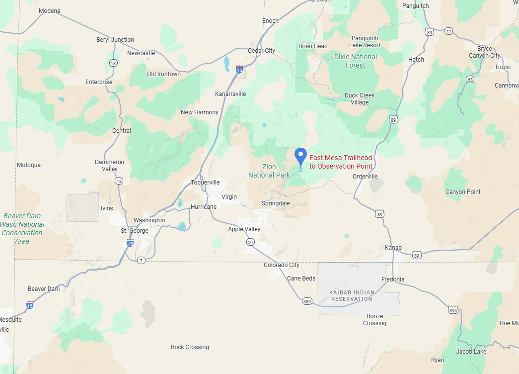
But more specifically, unlike most of Zion’s popular hikes, the East Mesa Trail is not located within the park’s main canyon. Instead, it begins on a mesa just east of the historic Zion–Mount Carmel Tunnel. This location provides a unique perspective: elevated, panoramic views of the canyon walls and the valley below, rather than the classic canyon-floor viewpoints.
About Zion National Park
Utah’s Iconic Red-Rock Canyon: Zion National Park lies in southwestern Utah, where towering sandstone cliffs rise abruptly from the desert floor. The park is defined by sheer canyon walls, narrow slot canyons, and lush river corridors, creating dramatic contrasts between towering rock faces and green valley bottoms. Zion Canyon, carved by the Virgin River, is the park’s centerpiece and one of the most visually striking landscapes in the American Southwest.
A Landscape Carved by Water and Time: Zion’s cliffs are composed primarily of Navajo Sandstone, formed from ancient desert dunes over 150 million years ago. Over time, the Virgin River and seasonal flash floods sculpted these layers into steep canyon walls, alcoves, and narrow corridors. The result is a landscape of massive vertical relief, smooth rock textures, and striking color variations that shift throughout the day as the light changes.
A Park Built for Scenic Hiking: Zion is renowned for its diverse hiking opportunities, ranging from riverside walks and canyon-floor trails to exposed routes with sweeping views. Short hikes like the Canyon Overlook Trail deliver big scenery with minimal effort, while longer routes such as Angels Landing and The Narrows offer more immersive adventures. This range makes Zion accessible to casual visitors and experienced hikers alike.
Dramatic Viewpoints and Canyon Overlooks: One of Zion’s defining features is its abundance of elevated viewpoints. Trails and roadside pullouts reveal sweeping vistas over Zion Canyon, Pine Creek Canyon, and the surrounding plateaus.
Easy Access, High Demand: Zion is one of the most visited national parks in the U.S., thanks to its proximity to Springdale and easy access via Highway 9 and the Zion-Mount Carmel Tunnel. While the park’s popularity can mean crowded trails and limited parking—especially during peak season—its shuttle system, short hikes, and well-maintained infrastructure make it possible to experience world-class scenery even on a tight schedule.
How to Get to Zion National Park
Zion National Park is best reached by car, as there is no public transportation directly to the park. While there is a shuttle system that navigates throughout the park during Zion’s busiest months, it only serves the main canyon and does not stop at the East Mesa Trail, making a personal vehicle necessary for this hike. However, you might still need to take a shuttle for the last three miles, depending on road conditions (more info further below).
Zion National Park Entrances
South Entrance (Springdale):
This is the main access point for Zion National Park and where the majority of visitors begin their trip. It provides direct access to Zion Canyon, the shuttle system, and popular trails such as Angels Landing, The Narrows, Emerald Pools, and the West Rim Trail. If you’re spending most of your time in the main canyon, this is probably where you’ll enter the park.
East Entrance (via Highway 9):
The east entrance is quieter and provides a more scenic arrival, passing through slickrock domes and sandstone formations before reaching the Zion–Mount Carmel Tunnel. The East Mesa and the Canyon Overlook Trails are located near this entrance, making it especially convenient for visitors approaching from Bryce Canyon, Page, Kanab, or the east side of Zion.
Driving Time
The drive between the West Entrance (Springdale) and the East Mesa Trail takes upwards of an hour, depending on traffic, tunnel conditions, and the state of the final dirt road. This is an important planning detail, as many first-time visitors assume the trail is close to the main canyon attractions.
All park roads, including the Zion–Mount Carmel Highway, are fully paved and suitable for standard vehicles. However, the final 3-mile stretch leading to the East Mesa Trailhead is an unpaved dirt road that generally requires a high-clearance or 4×4 vehicle, especially after rain or during wet conditions. Visitors without a suitable vehicle can access the trail via the East Zion Adventures shuttle, which departs from the Ponderosa Ranch Resort and provides reliable transport to the trailhead (see below for booking details).
Also, traffic delays at the tunnel can occur during peak seasons, which is another reason to plan your visit carefully.
Driving times to Zion National Park
- Las Vegas, NV: 260 km / 160 mi – about 2.5 hours
- St. George, UT: 70 km / 45 mi – about 1 hour
- Bryce Canyon National Park: 135 km / 85 mi – about 2 hours
- Page, AZ: 175 km / 110 mi – about 2.5 hours
- Flagstaff, AZ: 420 km / 260 mi – about 4.5 hours
These times assume clear weather and normal traffic conditions.
If you need to book a rental vehicle for your hiking excursion, we highly recommend using Discover Cars to get the best rates on your rental in Utah, Nevada and Arizona.
We also highly recommend Airalo (eSIM card) for your connectivity needs when travelling abroad. Airalo is the world’s first and largest eSIM store with eSIM plans for 200+ countries and regions worldwide.
Group Excursion from Vegas
Alternatively, if you don’t have a car and are staying in Las Vegas, you can still visit Zion National Park by joining an organized tour from the city. Several companies offer full-day excursions. This is the most popular tour, which allows for 6 hours of free time in the park, but it does not provide access to the East Mesa Trail:
East Mesa Trail – Trailhead, Parking & Fees
Trailhead Location
The East Mesa Trailhead (link to Google Maps) to Observation Point is located northeast of the Zion–Mount Carmel Tunnel, beyond the Zion Ponderosa Ranch Resort (link to Google Maps). All roads leading to the ranch are paved and suitable for all vehicles.
Driving to the Trailhead vs Taking the East Mesa Shuttle
Self-Driving
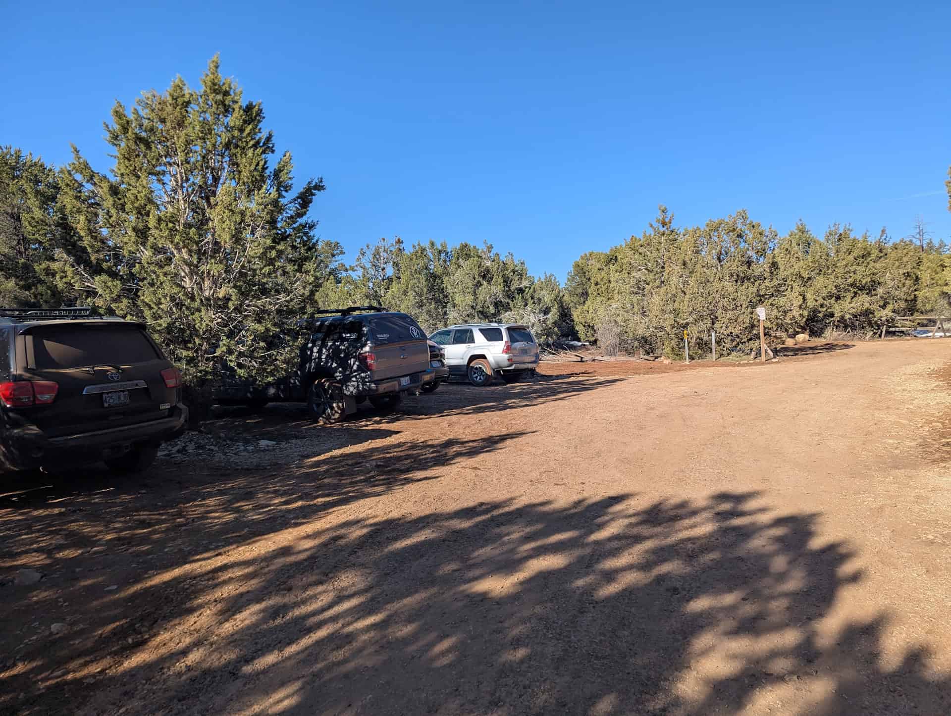
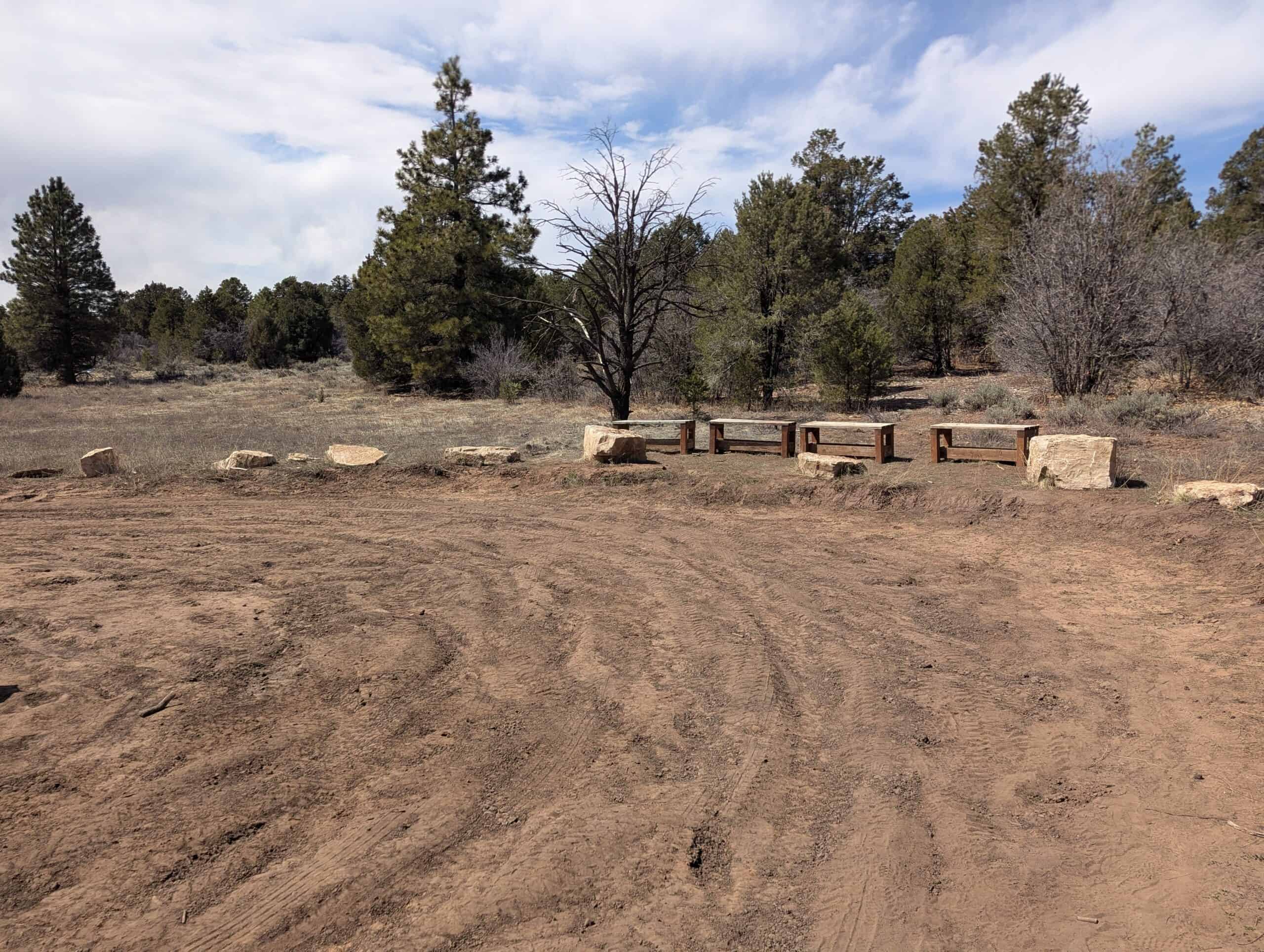
Although the East Mesa Trailhead is only about 3 miles from Zion Ponderosa Ranch, the final stretch of East Mesa Road is unpaved and often in poor condition. Deep ruts, mud after rain, and uneven surfaces are common, and a high-clearance 4×4 vehicle is strongly recommended, especially outside of dry summer conditions. During our visit, the road was rough enough that many standard SUVs would have struggled:


Another drawback of driving to the trailhead is the limited number of parking spaces, with only about 15 scattered spots. These fill quickly during peak hours, and there is no overflow parking once they’re full. For most visitors, especially those without a capable vehicle or experience driving on muddy backroads, self-driving can be stressful and unpredictable.
East Zion Adventures Shuttle – From Ponderosa Ranch
A far easier and more reliable option is the East Zion Adventures shuttle, which operates out of Zion Ponderosa Ranch Resort. This is a private shuttle service, completely separate from the free National Park Service shuttles that run inside Zion’s main canyon.
The shuttle runs on a set schedule and requires advance booking. While occasional walk-up availability is possible, it’s not guaranteed: booking ahead is strongly advised. Upon arrival at Zion Ponderosa, you’ll find ample free parking, then check in at the main lodge to confirm your reservation and departure time. At the end of your hike, they’ll pick you up at the pickup point near the trailhead:
Shuttle details (as of late 2025):
- Operating season: March 1 to November 30
- Cost: $7 per person, round-trip
- Frequency: Departures approximately twice per hour in the morning, tapering off around midday
- Return trips: Hourly pickups, typically on the half-hour
- Hiking is self-guided. The shuttle provides transportation only, not a guided hike
This shuttle option eliminates road-condition concerns, guarantees parking access, and makes Observation Point via East Mesa one of the most accessible ways to reach one of Zion’s best viewpoints without a strenuous climb.
You can book the shuttle online through East Zion Adventures.
Facilities
There are no toilets available along the trail. The only nearby ones that are available are in the Zion Ponderosa Ranch.
Trail Opening Hours
The trail is accessible year-round, 24/7, but the shuttle only starts between 7 and 9 am, depending on the season, and ends by mid-afternoon at the latest.
Entrance Fees for Zion National Park
Although the road to Zion Ponderosa Ranch and the East Mesa Trailhead lies outside Zion National Park, meaning you won’t pass through an entrance station if arriving from the east, the trail itself is located within park boundaries. As a result, all hikers are required to pay Zion National Park’s entrance fee or hold a valid park pass, even if they never drive through an official entrance station.
Anyone visiting Zion National Park, whether to hike, take a scenic drive, or simply enjoy the views, must pay the applicable entrance fee to the National Park Service.
Entrance Fees (per vehicle, valid 7 days)
Private vehicle: $35
Motorcycle: $30
Individual (on foot, bicycle, etc.): $20
Annual Pass Options
Zion Annual Pass: $70 – unlimited entry for one year from the month of purchase.
America the Beautiful Pass: $80 – valid for one year at all U.S. National Parks and more than 2,000 federal recreation sites nationwide. This is the best value if you plan to visit multiple national parks within a year.
Passes can be purchased at the park entrance stations, the Visitor Center, or online through the USGS website or via the REI store.
—> Most visitors exploring Utah’s “Mighty 5” parks (Arches, Bryce Canyon, Canyonlands, Capitol Reef, and Zion) should strongly consider the America the Beautiful Pass—it saves money and avoids the hassle of buying separate entry fees at each park.
East Mesa Trail (Observation Point) – Stats, Difficulty, and Map
Distance: 7 miles (11.3 km)
Route Type: Out & Back
Elevation change: 325 ft / 100 m (difference between trail high and low point)
Elevation gain: 705 ft / 215 m (cumulative elevation gain)
AllTrails rating (2025): 4.8, 8713 ratings
Duration: Most people complete the full trail in 2h30-3h
Trail difficulty level assessment:
Very Easy | Easy | Moderate | Moderately Challenging | Challenging
The trail is rated moderate primarily due to its length. Aside from the distance, the elevation gain is gradual and spread out over a long stretch (the elevation graph below is misleading because the X and Y axes are not on the same scale), and the trail surface is generally flat and non-technical, with no scrambling or exposed sections.
Not an AllTrails member yet? We highly recommend signing up for either their free or paid membership plans. The free plan allows you to find new trails and plan routes but it can only be used while hiking if you have access to mobile data. The paid membership plan (AllTrails+) allows you to download trail maps for offline use and provides live progress updates and off-route notifications.
If you are still uncertain – you should know that the All Trails mobile application was voted the 2023 iPhone App of the Year by Apple.
We find that AllTrails is a great tool to have when hiking, particularly for assisting with navigation when the trail is hard to locate and to help monitor your progress along the trail, which helps estimate how much time you’ll need to complete the trail.
East Mesa Trail – Trail Description and What to Expect
The East Mesa Trail begins at the East Mesa Trailhead, just beyond the dirt road access from Zion Ponderosa Ranch.
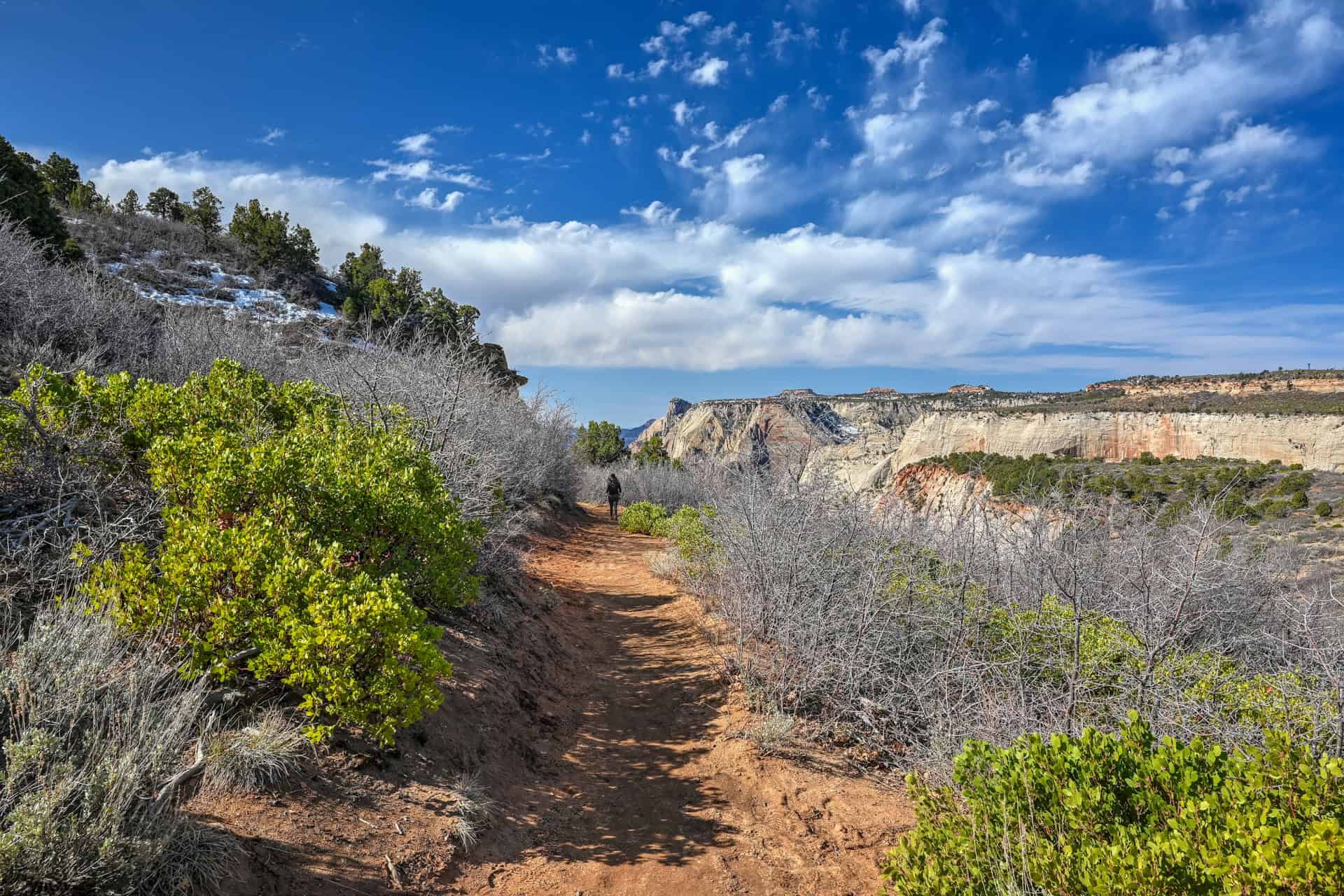
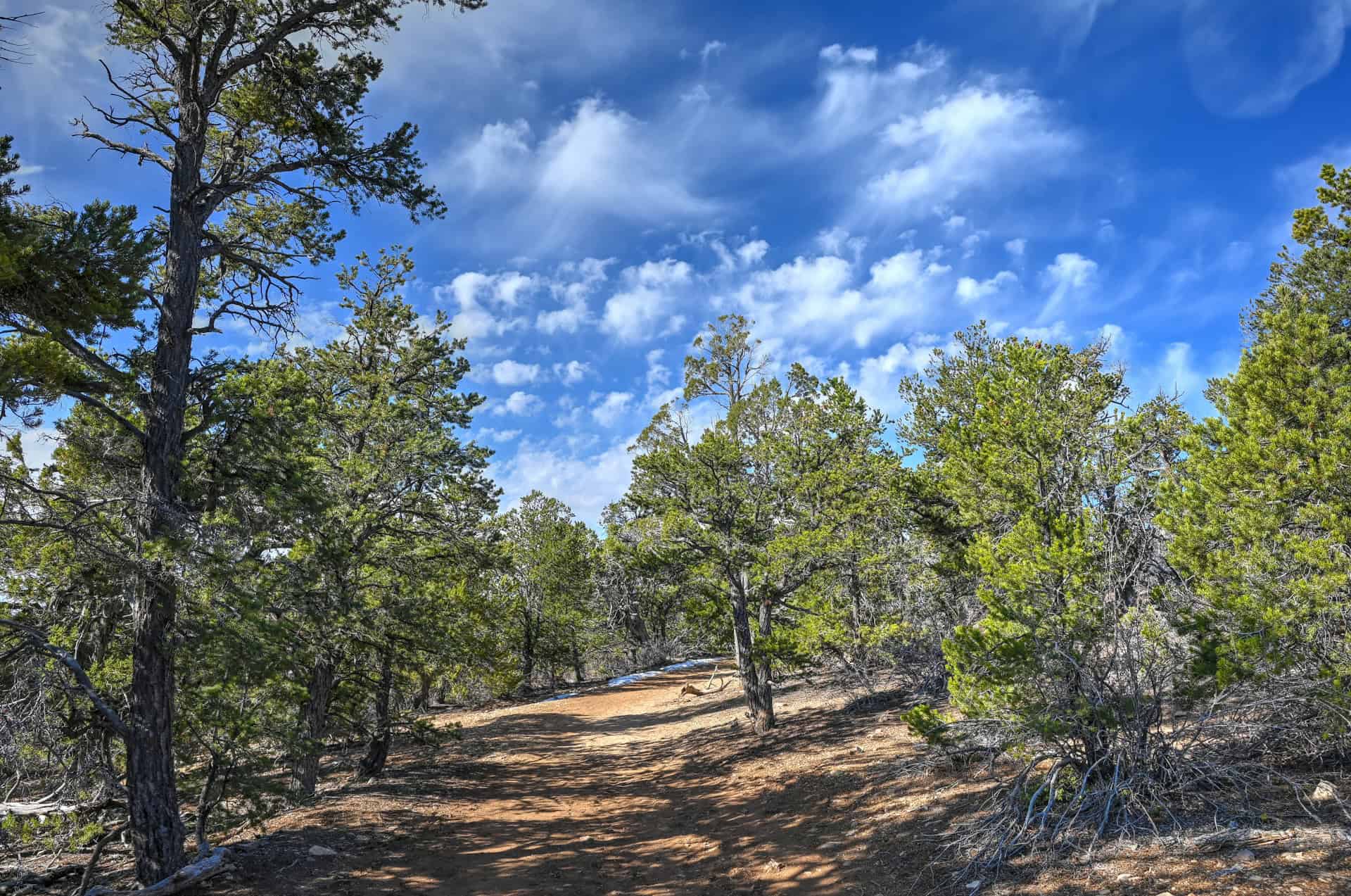
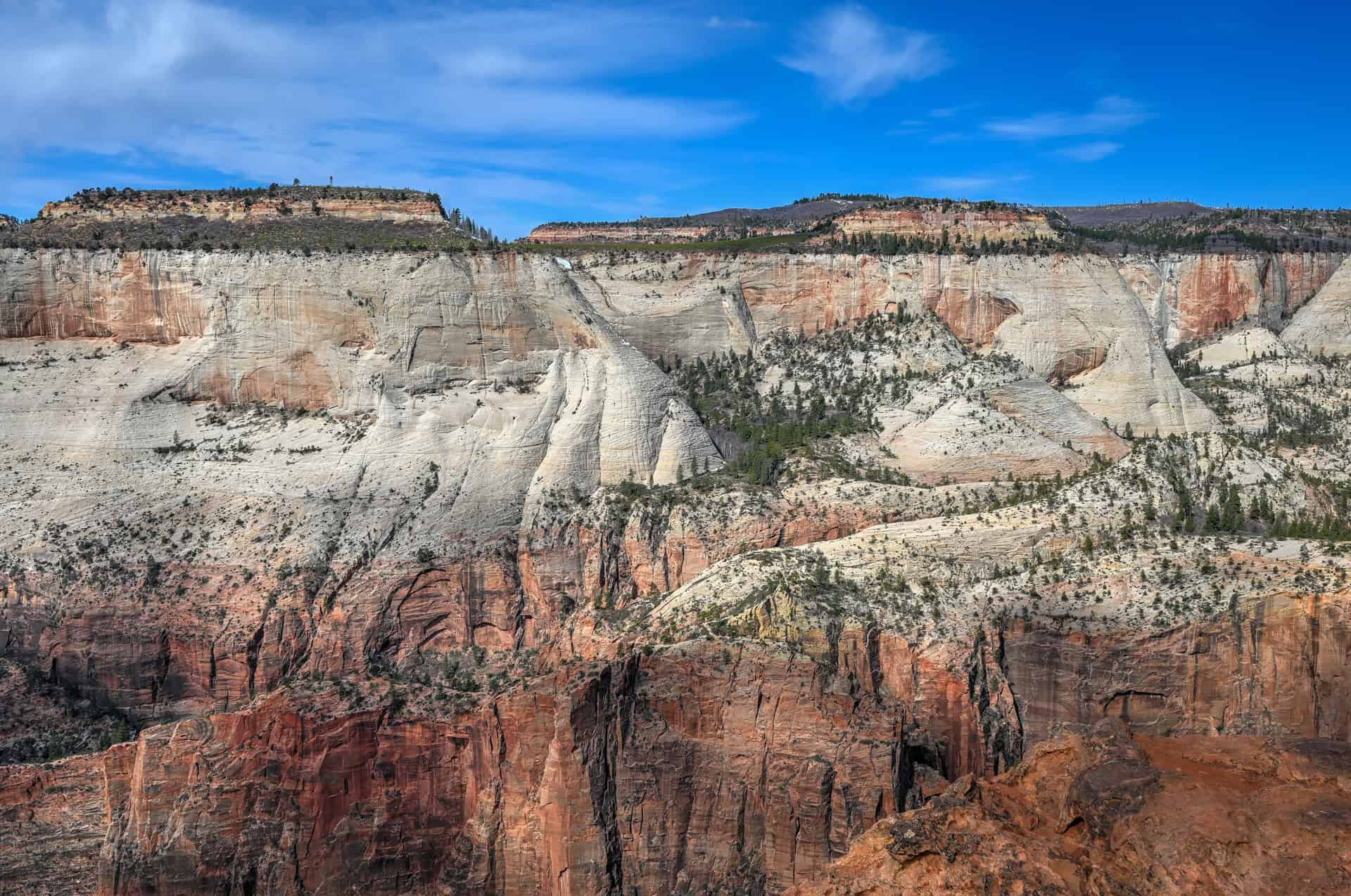
The route immediately distinguishes itself from the canyon-floor hikes: instead of narrow, cliff-hugging passages, you step onto a broad, sandy path that meanders across a high, open mesa. The surroundings feel expansive and quiet, with wide vistas stretching toward the main canyon and the distant peaks of Zion National Park.

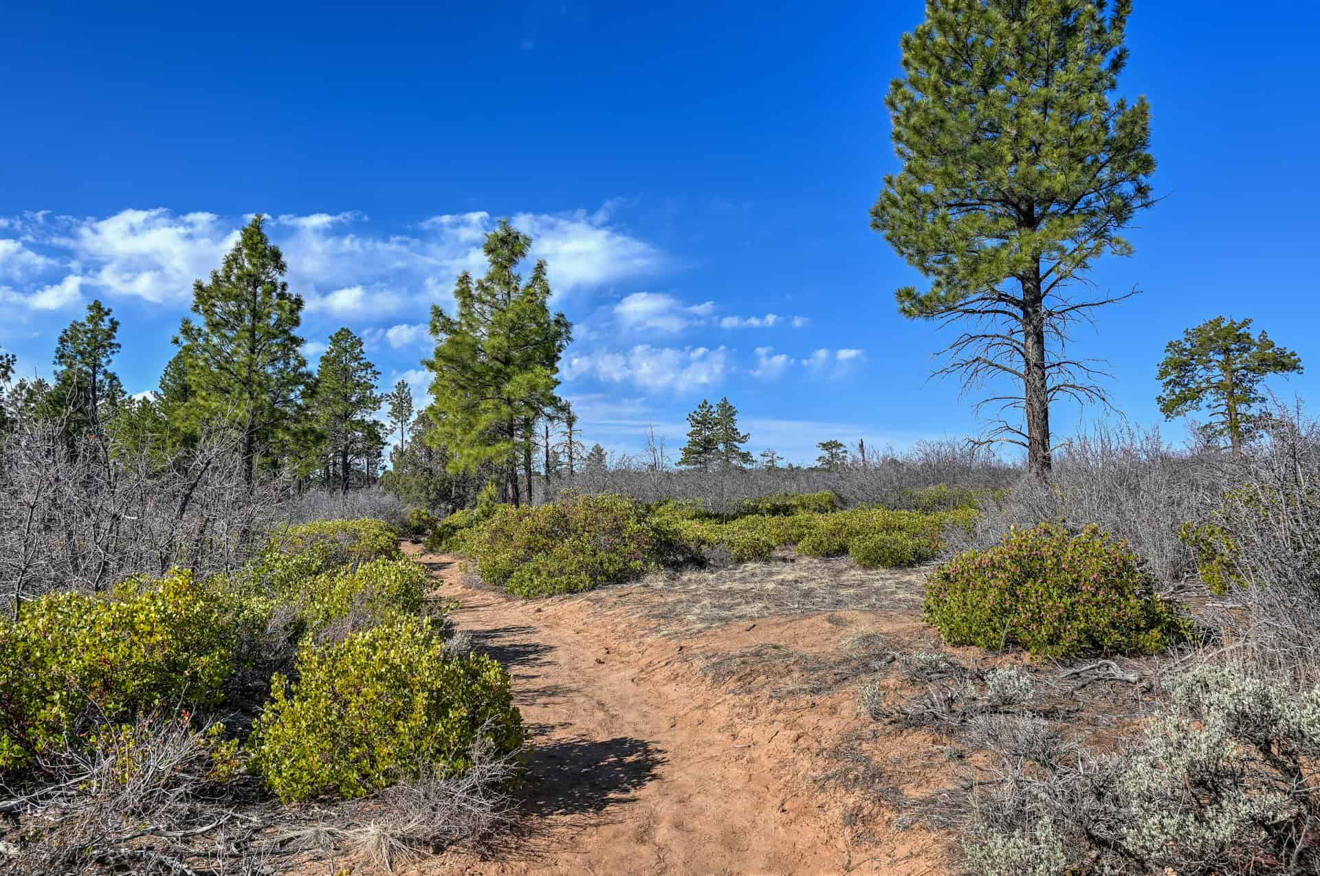
The first 4 km (2.5 miles) of the trail follow a gentle uphill slope. While the elevation gain is gradual, the wide-open terrain and mostly flat stretches make it feel deceptively easy. Soft sandy washes, scattered junipers, and eroded rock formations define the landscape as you gradually make your way toward the overlook.
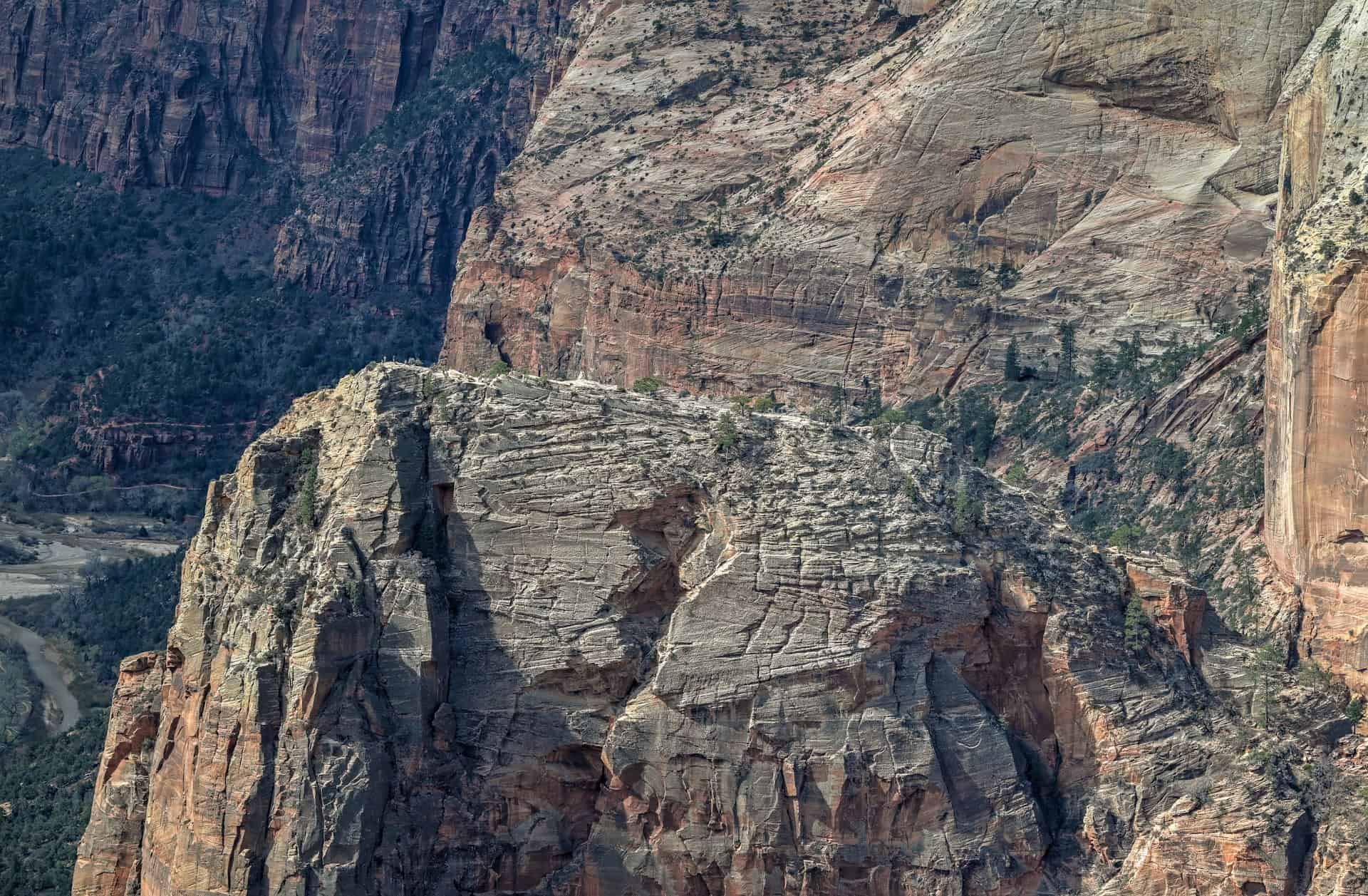
Around the same point where the trail starts to plateau (the 4 km/2.5 mi mark), the right side of the trail briefly opens up into a spectacular viewpoint over Mystery Canyon, offering a stunning glimpse of the deep, winding valleys below and the layered cliffs that characterize Zion’s dramatic topography. This makes for a natural pause, a photo opportunity, or a quiet moment to take in the scale of the surrounding park.


From there, the trail begins a slightly steeper descent over the remaining 1.5 km (just under 1 mile) toward Observation Point. But like the previous ascent, you really don’t feel the slope that much, and the scenery continues to be quite beautiful.


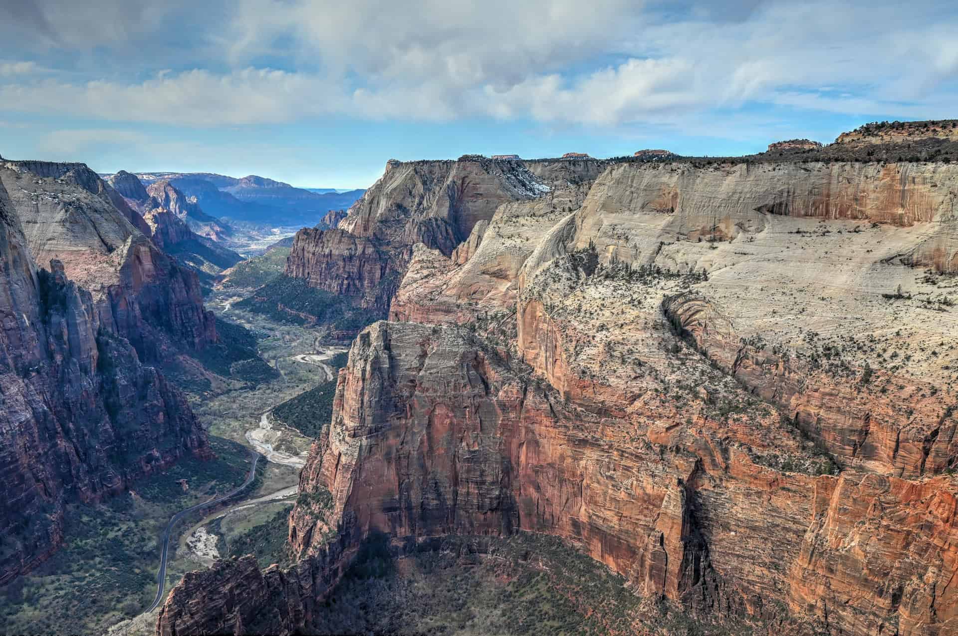
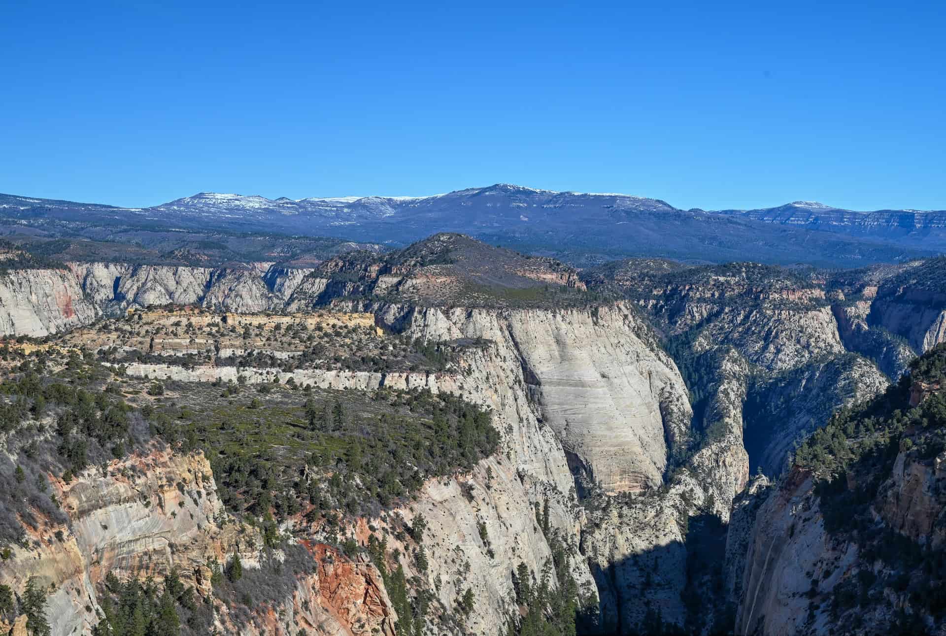
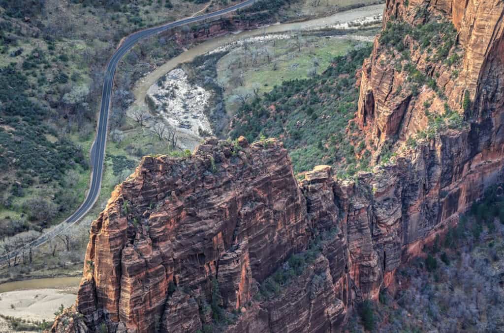
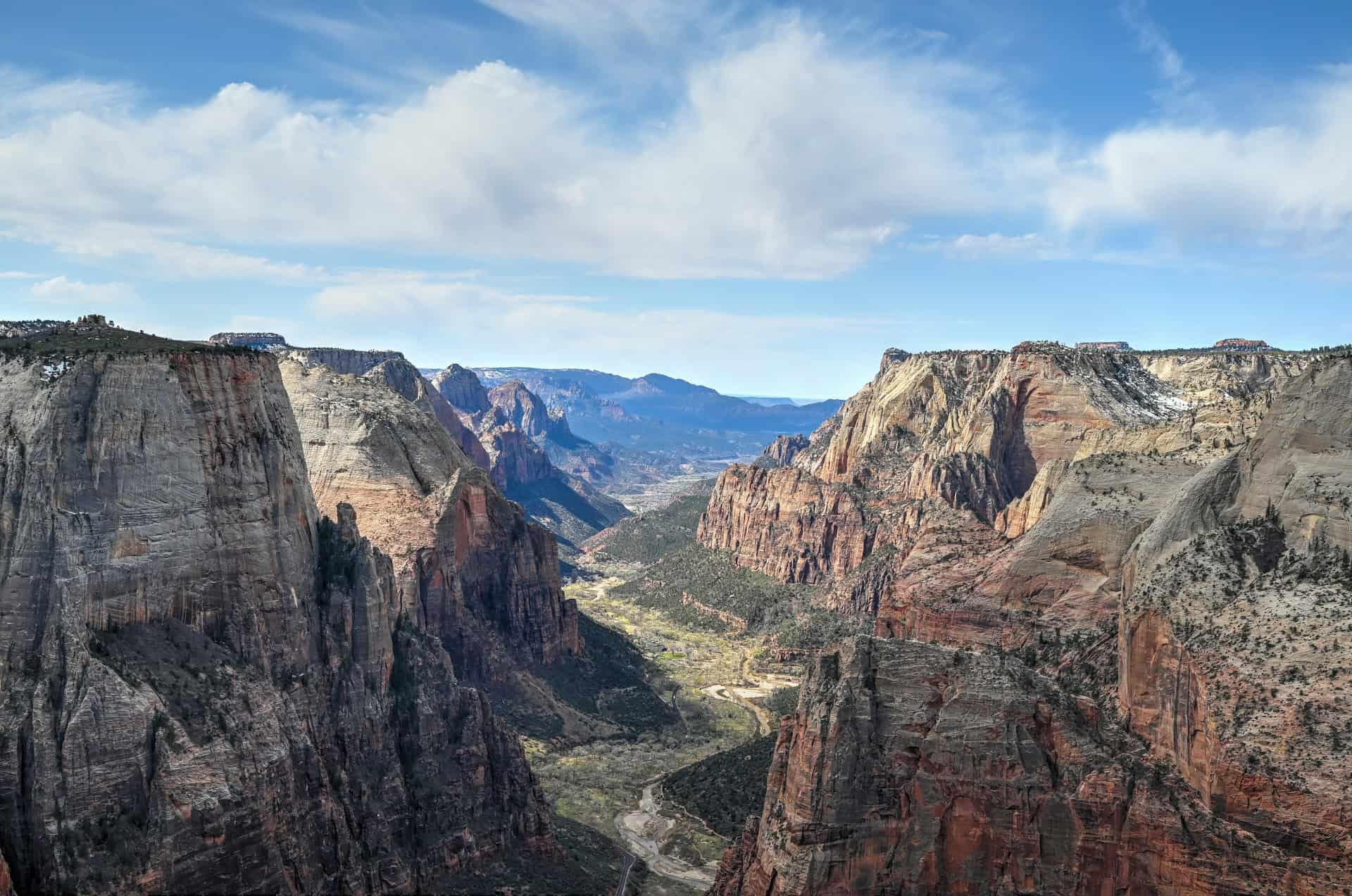
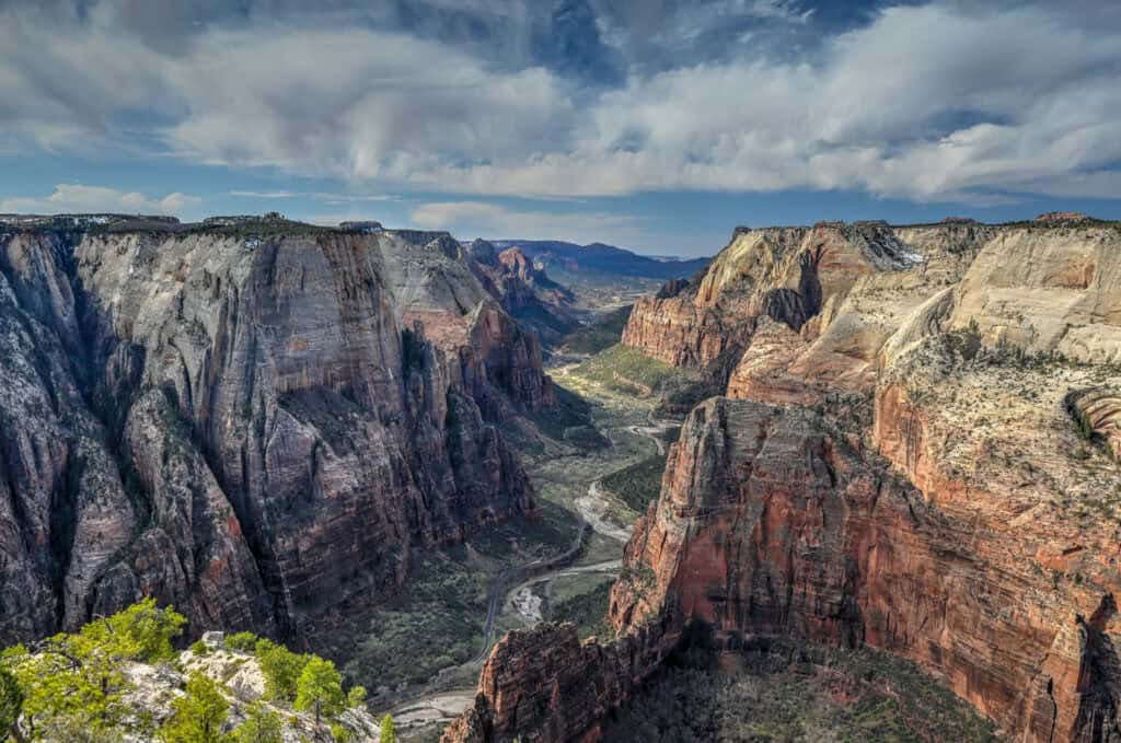
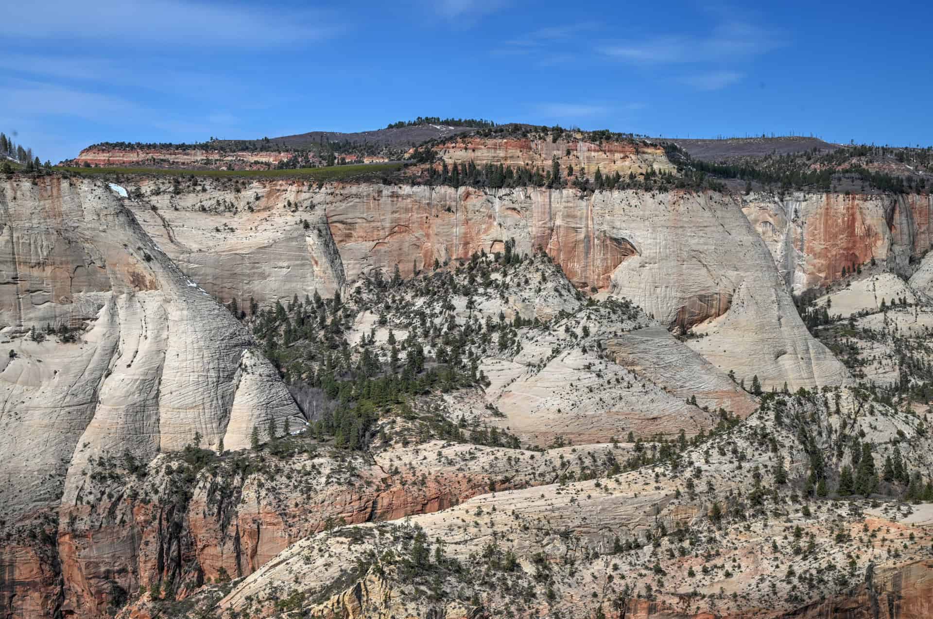
Once you reach Observation Point, the vista opens fully, and the main canyon of Zion sprawls below. In our opinion, it’s the most spectacular view to be had in Zion National Park.


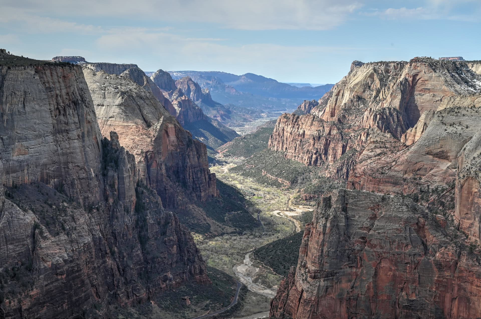
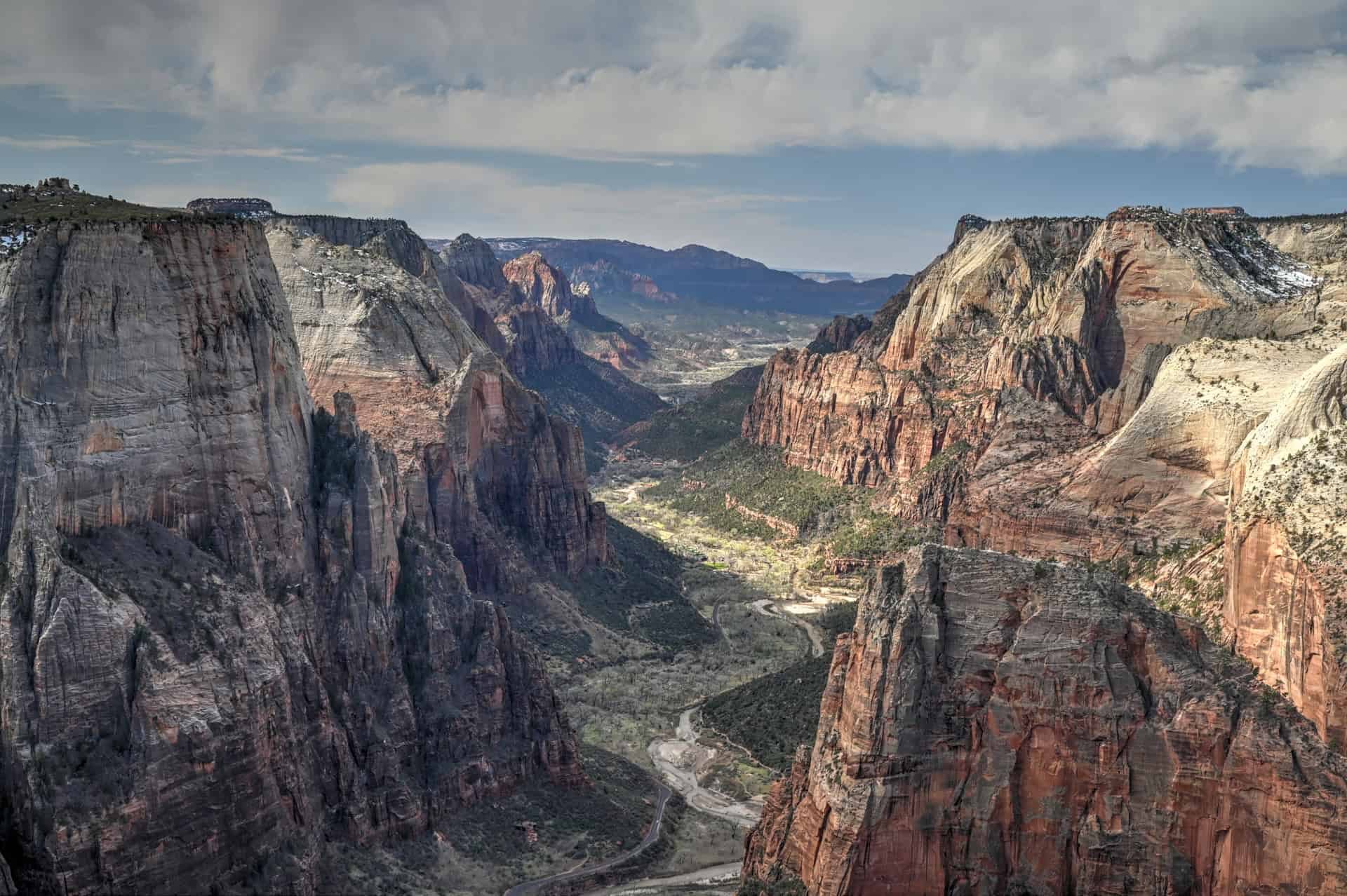
You can even see Angels Landing visible in the distance below and sandstone cliffs radiating outward in every direction.
Observation Point is also a great spot to enjoy a picnic, reflect on the grandeur of the park, or watch the local chipmunks and squirrels play around the rocky outcrops.


The return hike retraces the path across the East Mesa, offering another opportunity to admire the panoramic vistas from different angles.
East Mesa Trail – Additional Details and Hiking Tips
Canine companions: Dogs are not permitted on the East Mesa Trail. Zion National Park only allows pets on the Pa’rus Trail; all other trails, including East Mesa to Observation Point, are off-limits to pets.
Trail environment: The East Mesa Trail offers a wide, open desert setting with panoramic views over the main Zion Canyon. Unlike canyon-floor hikes, the trail meanders across high mesa terrain, with gentle rises and occasional sandstone outcrops. Shade is minimal, so hikers should bring plenty of water, sunscreen, and hats.
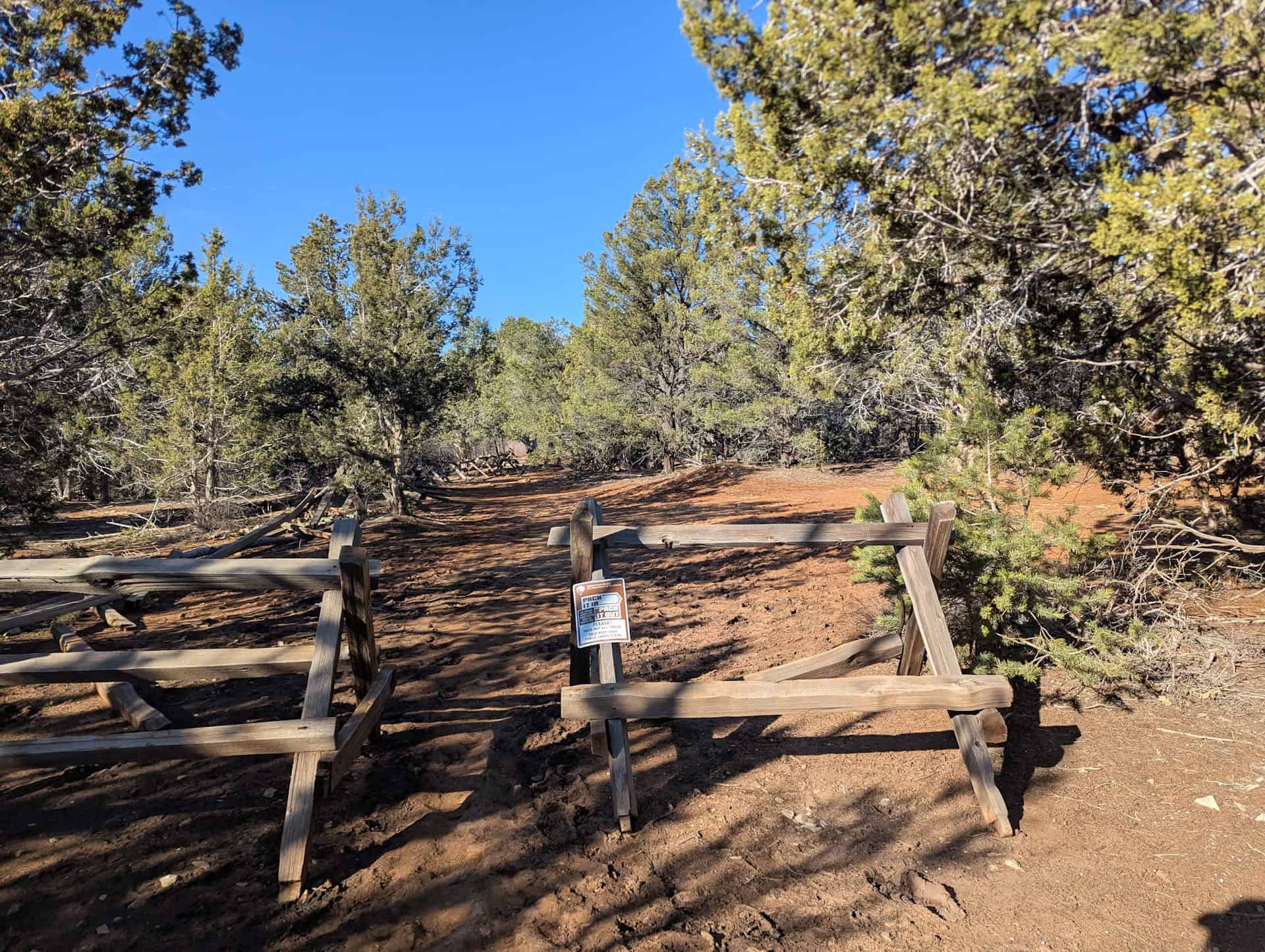
Route signage: The trail is clearly marked with cairns and occasional signs near key junctions. While navigation is generally straightforward, bringing a downloaded map or GPS is useful.
Trail surface / Technical aspects: The path is primarily packed dirt and sandy soil, with occasional rocky stretches. There are no technical climbs or exposed ledges, making the footing relatively stable.
Slope and effort: The elevation gain is gradual (average slope grade of 4%), spread across the trail, with few steep sections. Most hikers find the terrain manageable, though the distance requires basic endurance and adequate preparation.
Previous Hiking Experience: This hike is suitable for hikers with some prior experience or moderate fitness. Beginners can complete it with sufficient water and breaks, but the length can feel challenging if unprepared.
Cell Service: Coverage is inconsistent and often absent along parts of the trail. Download offline maps and inform someone of your hiking plan if going solo.
Leave No Trace: Stick to the designated trail to protect fragile soils and plant life. Pack out all trash and avoid creating new paths. Noise carries, so keep voices low to preserve the natural ambiance.
Bugs: Insects are minimal. You may encounter flies or gnats in warmer months, but mosquitoes are uncommon.
Equipment: No technical gear is required. Bring sturdy footwear, sun protection, water, snacks, and a hat. Trekking poles are optional, useful on sandy stretches or mild inclines.
Weather and Exposure: The trail is mostly exposed, with minimal natural shade. Sun protection is essential. Wind can be strong on exposed sections of the mesa, and slickrock may become slippery after rain.
Wildlife: You may spot birds, lizards, or small mammals. Wildlife encounters are typically brief. Stay alert and give animals space.
Current Trail Conditions: Check the Zion National Park alerts page before your visit for updates on road closures, tunnel traffic controls, weather impacts, or temporary trail restrictions.
Best Time to Hike the Trail
Best Time to Hike the Trail
Observation Point via East Mesa Trail is open year-round, but conditions, crowds, and the overall hiking experience vary with the seasons. Because it’s a longer, exposed trail on the East Mesa, timing your visit can significantly impact comfort and enjoyment.
Spring (March–May):
Spring is one of the best seasons for this hike. Daytime temperatures typically range from 65–85°F (18–29°C), making long stretches of exposed mesa more comfortable. Desert wildflowers may begin to bloom along the trail, and the softer light accentuates the red and orange sandstone cliffs of Zion Canyon. The trail is moderately popular in spring, so early departures are recommended, particularly if using the East Mesa Shuttle from Zion Ponderosa Ranch.
Summer (June–September):
Summer brings high temperatures often exceeding 90°F (32°C) along the mesa. The trail is largely exposed with little shade, so heat exhaustion is a risk; bring plenty of water and consider early morning starts. Monsoon storms can create flash flood risks in connecting canyons and make dirt roads to the trailhead muddy or impassable. Shuttle service from the ranch remains a safer option during wet conditions.
Fall (October–November):
Fall is another excellent time to hike East Mesa. Temperatures generally settle in the 70s–80s°F (21–27°C), providing comfortable conditions for the trail’s 7.5-mile round trip. Light is softer and warm in the afternoon, making views across the main canyon especially photogenic. Crowds are lower than in spring, so shuttle rides and parking are easier to secure.
Winter (December–February):
Winter offers quiet trails and clear air, with daytime highs often between 50–60°F (10–16°C). Mornings can be chilly, and frost or light snow is possible on the mesa. The trail itself is generally dry, but the dirt road to the trailhead can be muddy after storms, making the shuttle service a safer option if conditions are poor.
Quick Summary – When to Visit
Spring and fall provide the best combination of mild temperatures, clear skies, and manageable trail conditions. Early mornings or late afternoons are ideal to avoid midday sun. Summer requires careful planning due to heat and storm risks, while winter is peaceful but may require caution for icy patches and muddy road conditions.
Hiking Packing List
All Trails subscription – This comes in really handy for areas with little or no cell reception, as the annual subscription allows you to download trail maps for offline use.
External Battery – If you are using your phone to track your progress along the trail or to help with navigation, you certainly don’t want your phone to die on you. That’s especially true in the unlikely event that you might get hurt or need assistance.
Hiking poles – These can be particularly useful in steep trails or muddy/boggy trail conditions.
Water Filter Bottle – The Life Straw bottle is an advanced water bottle with a filter that not only improves water taste but more importantly filters out bacteria and parasites, chemicals and microplastics.
Headlamp – very practical and a smart choice if you plan to start your hike before sunrise or finish it after sunset.
Is The East Mesa Trail to Observation Point Worth It?
We definitely think so! Observation Point via East Mesa offers some of the most sweeping panoramic views of Zion National Park. Unlike canyon-floor trails, this route gives hikers an elevated perspective above the main canyon, including the Court of the Patriarchs, Angels Landing, and the vast expanse of the Virgin River Valley.
Why You Might Enjoy It:
– Observation Point is, in our opinion, the most stunning vista in all of Zion
– Quiet experience and few crowds compared to trails along Zion’s main canyon
– Mostly flat trail with a slow, gradual climb/descent, suitable for many fitness levels
Why it Might Not Be for You:
– The trail is significantly longer than most other Zion trails, and is mostly exposed with minimal shade
– The trailhead is a long drive from Zion’s main canyon
– Driving to the trailhead can be challenging, and you might need to book the shuttle service ahead of time
Want to Know More About Zion National Park?
We’ve put together a dedicated Zion National Park Guide that covers the park’s must-see viewpoints, iconic hikes inside the main canyon, scenic drives like the Zion–Mount Carmel Highway, and practical tips for navigating shuttle season, parking, and crowds. It’s the perfect companion for building a well-balanced Zion itinerary or fitting the park smoothly into a Utah road trip. We also have individual hiking guides for some of our favorite Zion trails:
Scout Lookout & the West Rim
If you’re looking to experience Zion’s vertical scale and classic canyon views, the hike to Scout Lookout and beyond along the West Rim is one of the park’s most iconic adventures. The trail climbs steadily through a series of dramatic switchbacks, gaining elevation quickly and revealing sweeping views of Zion Canyon below. At Scout Lookout, the closest you can get to Angels Landing without a permit, you’re rewarded with a breathtaking perch high above the valley, with sheer cliffs and sandstone towers stretching in every direction. Continuing onto the West Rim opens up quieter terrain, expansive viewpoints, and far fewer crowds. It’s a challenging but immensely rewarding hike that showcases Zion at its most dramatic. For more trail details and hiking tips, see our Hiking Guide for Scouts Lookout & the West Rim.


The Watchman Trail
If you want a shorter, accessible hike that still delivers quintessential Zion scenery, the Watchman Trail is a perfect choice. This trail climbs gradually through scrubby desert terrain and scattered junipers, offering a mix of shaded sections and open views as you approach the base of the Watchman rock formation. Along the way, you get expansive panoramas of the lower canyon, the Virgin River, and the town of Springdale framed by the towering sandstone cliffs. At the viewpoint, the Watchman itself dominates the scene, and you can take in the classic West Temple and Altar of Sacrifice formations across the canyon. For more trail details and hiking tips, see our Watchman Trail Hiking Guide.


Where to Stay Near Zion National Park
If you want to stay close to Zion without dealing with limited parking at the Visitor Center or juggling both the Springdale shuttle and the Zion Canyon shuttle, the northern end of Springdale is one of the most practical places to base yourself. Lodging here puts you within a short walk or drive of the park entrance, allowing you to start early and simplify logistics during peak season.
Below are two solid, well-located options that balance comfort, convenience, and access. Both are within a 20-minute walk of the park’s southern entrance.
Best Western Plus Zion Canyon Inn & Suites
What sets it apart: Reliable comfort and one of the closest hotel locations to the park entrance.
This modern Best Western sits at the quiet northern end of Springdale, within easy walking distance of Zion’s pedestrian entrance. Rooms are clean and spacious, and amenities include an outdoor pool, hot tub, and complimentary breakfast. Its location makes it especially appealing for hikers planning early starts, as you can avoid parking constraints and step straight into the shuttle system.
Cliffrose Springdale, Curio Collection by Hilton
What sets it apart: Riverside setting with resort-style grounds, right at the edge of the park.
Cliffrose is one of the closest properties to Zion’s entrance, offering direct access to the Virgin River and beautifully maintained gardens. While more polished than a standard mid-range hotel, it remains a practical choice thanks to its walkability, on-site amenities, and proximity to the park. It’s well-suited for travellers who want a comfortable base with a quieter, more relaxed atmosphere after long hiking days.
Booking Tip: Springdale accommodations fill quickly, particularly in spring and fall. Staying near the park entrance is especially valuable during shuttle season, so booking well in advance is strongly recommended.
Canyon Overlook Trail – Frequently Asked Questions (FAQ)
Where is the East Mesa Trail located?
The trail begins at the East Mesa Trailhead, located northeast of the Zion–Mount Carmel Highway tunnel. While the trailhead is outside the main canyon, the hike itself lies within park boundaries, so all hikers must pay the Zion entrance fee. Access is via a 3-mile dirt road that requires a high-clearance 4×4 vehicle unless using the shuttle service from Zion Ponderosa Ranch.
How do I get there – self-drive or shuttle?
–Self-Drive: The dirt road is bumpy, narrow, and can be slippery in wet conditions. Only high-clearance 4×4 vehicles should attempt it. Parking at the trailhead is very limited, with roughly 15 spaces available.
–Shuttle Service: Zion Ponderosa Ranch offers a private East Mesa Shuttle from March 1–November 30. The shuttle costs $7 per person (late 2025), runs twice per hour until midday, and includes return service. Reservations are recommended, as walk-ons aren’t guaranteed a spot. Shuttle departure is from the ranch, which provides ample parking.
Is the East Mesa Trail difficult?
The trail is rated Moderate, primarily due to its length rather than steepness or technical difficulty. The path is largely flat with few technical sections, making it manageable for hikers with reasonable fitness.
Is the trail safe for children?
Yes, for older children with good stamina, but keep in mind it’s a long hike with limited shade. Bring water and sun protection. Younger children may find the distance challenging.
Can you bring dogs on the East Mesa Trail?
No. Pets are only allowed on the Pa’rus Trail. Dogs and other pets are prohibited on East Mesa Trail.
Are drones allowed?
No. Drones are strictly prohibited anywhere within Zion National Park, including the East Mesa Trail and surrounding viewpoints. Launching, landing, or operating unmanned aircraft is not allowed due to safety concerns, wildlife disturbance, and visitor experience impacts. Violations can result in fines and confiscation of equipment.
Explore More Utah National & State Park Guides
Continue exploring Utah with these detailed guides:
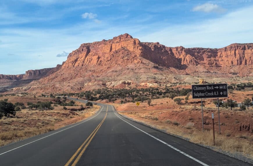
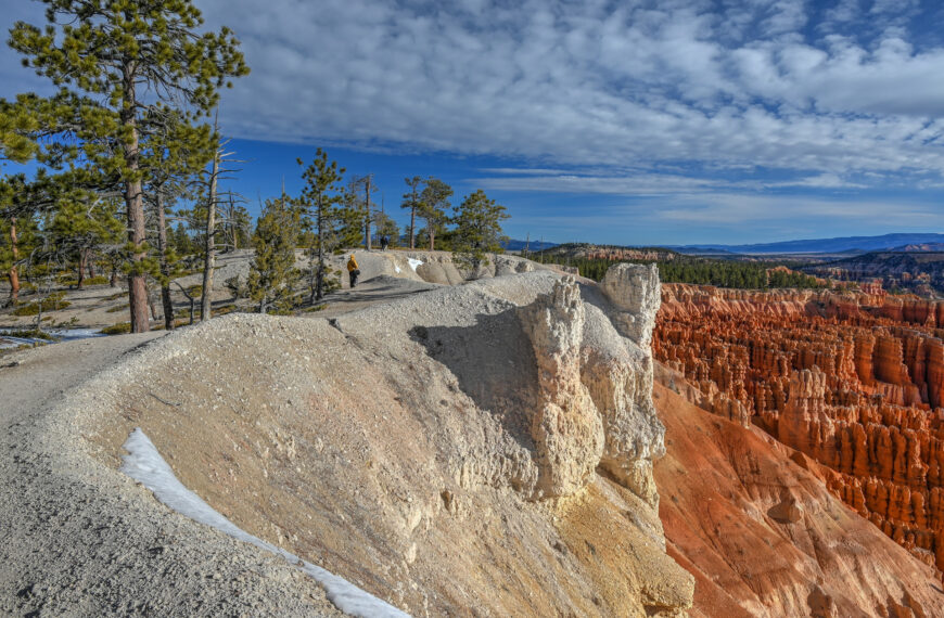
Bryce Canyon National Park Guide
Capitol Reef National Park Guide
Snow Canyon State Park Guide
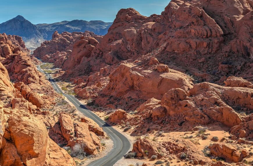
Valley of Fire State Park Guide
Goblin Valley State Park Guide
Photography Gear
If you like our photography, you might be interested in some of the gear we use to shoot our travel and hiking destinations.
Camera Body – Nikon Z 6ii Fx-series Mirrorless Body
Main Lens – NIKON 24-120mm F/4G ED VR AF-S
Zoom Lens – Sigma 745-306 150-600mm f/5-6.3
Polarizing filters – Urth Circular Polarizing (CPL)
Camera Tripod – K&F Concept 64-inch Camera Tripod
Mini-tripod – Lammcou Flexible Camera Tripod
Camera/hiking backpack – Vanguard Alta Rise 48 Backpack
Universal Travel Adapter – VYLEE Universal International Power Travel Plug
Other Travel Essentials
Travel Insurance
SafetyWing is a travel insurance company that offers comprehensive coverage for travellers. Includes Medical Insurance and Travel Insurance. Primarily geared towards long-term travellers, digital nomads, and expats.
e-Sim cards
Airalo is the world’s first and largest eSIM store with eSIM plans for 200+ countries and regions worldwide. With Airalo eSIMs, travellers can get connected the moment they land at their destination and avoid nasty data roaming charges
eSIMS are a sustainable alternative to single-use SIM cards – they are 100% digital, require less energy to produce and be re-used rather than disposed of.
Car Rentals
Discover Cars is our go-to website for car rentals. We almost always find our preferred rate there.
Transfer from Airport
Welcome Pickups is our favourite private transfer service, which you can pre-book at a fixed price. Currently available in 220 cities all over the world (mostly in Europe, but with several major cities in Asia, the Middle East and the US).
Kiwitaxi is another private transfer service – we haven’t tried it yet, but it’s currently available in a few more countries (102 as of 2024).
Hotels and Accommodations (coming soon)
Photography Prints
If you found this blog useful, you can help support our blog by purchasing low-cost digital prints. Printed physical prints are also available for purchase.


—–
Well, that wraps it up! We hope you enjoyed our Zion National Park Hiking Guide for the Observation Point via East Mesa Trail and that it will prove useful for planning your trip.
—–
You might also be interested in these related pages: